Search Listings matching "ukraine" in Europe > Russia / Baltic / Black Sea region
![[No title] Russland.](/uploads/cache/28943-250x250.jpg)
[No title] Russland.
Map depict the area north of the Black Sea, including the cities of Odessa, Kischenau, Jelisawetgrad, Kherson.From "W. E. A. von Schliebens Atlas von Europa nebst Ko...
- $250 / ≈ €234
Place & Date: Leipzig, G. J. Göschen, ca 1825-1830
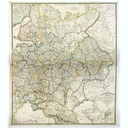
![[No title] Russland.](/uploads/cache/28944-250x250.jpg)
[No title] Russland.
Map depict the area north of the Black Sea, including the cities of Jekaterinoslaw, Bachmut, Alexandrowsk.From "W. E. A. von Schliebens Atlas von Europa nebst Koloni...
- $300 / ≈ €281
Place & Date: Leipzig, G. J. Göschen, ca 1825-1830
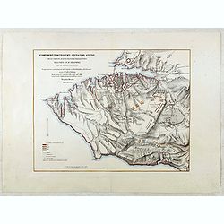
![[No title] Oesterreich. B. Galizische erbstaaten Koenigr. Galizien Kreis 12. Sambor 13. Stry 17. Stanislawow.](/uploads/cache/28948-250x250.jpg)
[No title] Oesterreich. B. Galizische erbstaaten Koenigr. Galizien Kreis 12. Sambor 13. Stry 17. Stanislawow.
Map depict the area north of the Black Sea, including the cities of Stanislawow, Drobicz, Sambor.From "W. E. A. von Schliebens Atlas von Europa nebst Kolonien für G...
- $300 / ≈ €281
Place & Date: Leipzig, G. J. Göschen, ca 1825-1830
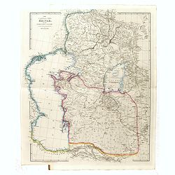
![[No title] Russland. Gouv. 24 Woronesh 28. Slobodsk Ukraine.](/uploads/cache/28949-250x250.jpg)
[No title] Russland. Gouv. 24 Woronesh 28. Slobodsk Ukraine.
Map depict the area north of the Black Sea, including the cities of Kharkow, Achtyrka, Woronesh, etc.From "W. E. A. von Schliebens Atlas von Europa nebst Kolonien f�...
- $300 / ≈ €281
Place & Date: Leipzig, G. J. Göschen, ca 1825-1830
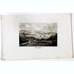
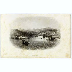
Sewastopol. (Sebastopol)
View of Sebastopol. Engraved by Leopold Zechmayer who was active in Vienna.
- $20 / ≈ €19
Place & Date: Vienna, ca. 1835
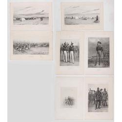
Set of 5 lithographes of Camp de Vosnessensk, 1837.
Lot of seven lithographs of life scenes in a French military camp in Vosnessensk, Crimea. After designs and lithographed by Denis Auguste Marie Raffet, a master draftsm...
- $300 / ≈ €281
Place & Date: Paris, 1842
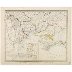
The Russian Dominions in Europe ... with the Post Roads & New Governments from the Russian Atlas of 1806 by Jasper Nantiat.
A two-sheet wall map of Russia covering from the Artic Sea to the Black and Caspian Seas and from East Prussia and Moldova to the Aral Sea and Tobolsk. Modern day nations...
- $500 / ≈ €468
Place & Date: London, ca. 1843
The Caspian sea Khivah and the surrounding country
Map of Ukraine published by John Arrowsmith (1790-1873) in his "The London Atlas of Universal Geography, Exhibiting the Physical & Political Divisions of the Var...
- $450 / ≈ €421
Place & Date: London, 2-1846
![[Untitled map of Black Sea].](/uploads/cache/37349-250x250.jpg)
[Untitled map of Black Sea].
Very detailed and rare map of Black Sea region. The map has elaborate floral borders. Prepared by Joseph Scheda in Vienna.
- $200 / ≈ €187
Place & Date: Vienna, 1845-1847
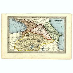
Armenia major, Iberia etc. by J.Archer.
Early Missionary map of Armenia from the "Atlas of educational maps for the use of schoolmasters" (1847), published by SPCK - the Society for Promoting Christia...
- $150 / ≈ €140
Place & Date: London, 1847
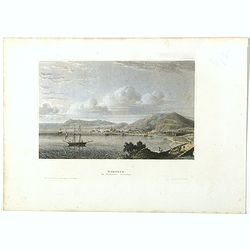
Kertsch im südlichen Russland. (Kerch)
Steel engraving with a panoramic view of the town of Krech, published in "Meyers Universum oder Abbildung und Beschreibung des Sehenswerthesten und Merkwürdigsten d...
- $15 / ≈ €14
Place & Date: Hildburghausen, 1848
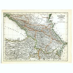
Der Kaukasische Istmus . . .
Detailed contemporary colored map of the countries of the Caucasus Mountains. Steel engraving appeared in "Meyer's Lexicon. Atlas der Geographie". Engraved by C...
- $45 / ≈ €42
Place & Date: Hildburghausen, 1849
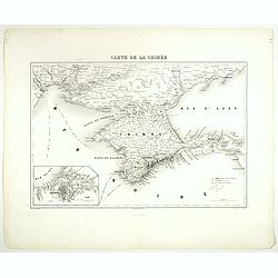
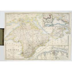
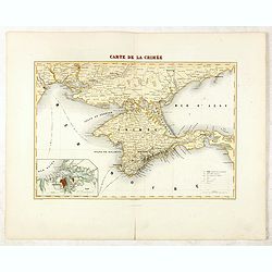
Carte de la Crimée.
Attractive map of Crimea with inset plan of Sevastopol, prepared by Alexandre Aimé Vuillemin (1812-1886). A road system and the ferry lines are drawn in.Engraved by Jaco...
- $150 / ≈ €140
Place & Date: Paris, ca. 1850
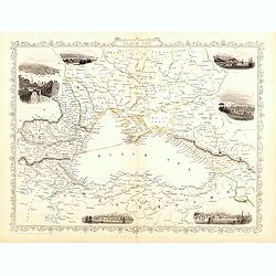
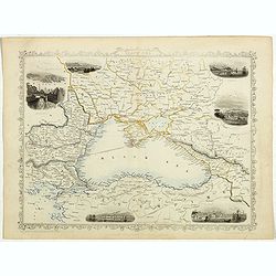
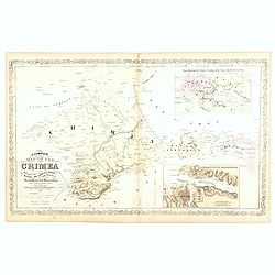
Black Sea.
Decorative steel engraved map of the Black Sea with inset views of Sebastopol and Odessa. There are also vignettes of Constantinople, Sinope and Varna. Taken from "T...
- $110 / ≈ €103
Place & Date: London, London Printing and publishing Company of London, ca. 1851
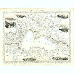
Black Sea.
Decorative steel engraved map of the Black Sea with inset views of Sebastopol and Odessa. There are also vignettes of Constantinople, Sinope and Varna. Taken from "T...
Place & Date: London, London Printing and publishing Company of London, ca. 1851
Black Sea.
Decorative steel engraved map of the Black Sea with inset views of Sebastopol and Odessa. There are also vignettes of Constantinople, Sinope and Varna. Taken from "T...
- $90 / ≈ €84
Place & Date: London, London Printing and publishing Company of London, ca. 1851
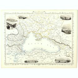
Black Sea.
Decorative steel engraved map of the Black Sea with inset views of Sebastopol and Odessa. There are also vignettes of Constantinople, Sinope and Varna. Taken from "T...
- $90 / ≈ €84
Place & Date: London, London Printing and publishing Company of London, ca. 1851
Black Sea.
Decorative steel engraved map of the Black Sea with inset views of Sebastopol and Odessa. There are also vignettes of Constantinople, Sinope and Varna. Taken from "T...
Place & Date: London, London Printing and publishing Company of London, ca. 1851

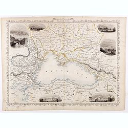
Black Sea.
Decorative steel engraved map of the Black Sea with inset views of Sebastopol and Odessa. There are also vignettes of Constantinople, Sinope and Varna. Taken from "T...
- $90 / ≈ €84
Place & Date: London, London Printing and publishing Company of London, ca. 1851

The town & harbour of Sevastopol with the batteries & approaches. . .
Rare colored linen backed map showing the harbour and town of Sevastopol, with soundings. In upper left corner a inset map (65x150mm) of the Black Sea. In bottom part a l...
Place & Date: London, March 27th, 1854
The Crimea by James Wyld Geographer to the Queen & H.R.H. Prince Albert.
The second edition of this folding map of Crimea. In the upper right corner, an inset map of the areas around the Black Sea, "The Town & Harbor of Sevastopol wit...
Place & Date: London, 1854
Selling price: $250
Sold in 2017
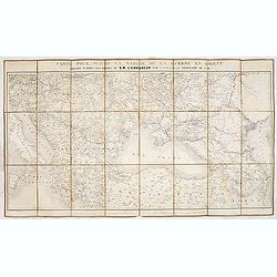
Carte pour suivre la marche de la guerre en Orient, dressée d'après les ordres de l'empereur: par L. Sagansan.
Detailed folding map of the theatre of war in the Balkans, Ukraine and around the Black Sea, indicating the Austrian, Russian and Turkish spheres of influence, prepared b...
Place & Date: Paris, ca. 1854
Selling price: $50
Sold in 2019

The Crimea, chiefly from surveys made by order of the Russian government. . .
Map of Crimea and the Sea of Azov. In lower right corner two inset maps showing Sebastopol inlet and harbour and a second one with the Black Sea. This second maps shows t...
Place & Date: London, 1854
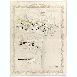
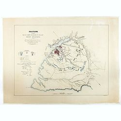
Plan of the battle of Alma.
Fine plan drawn and engraved by John Rapkin "from English and French Official Documents" Published 1858 by the London Printing and Publishing Co., London. Shows...
- $150 / ≈ €140
Place & Date: London, 1854
Siege of Sebastopol.
Detailed map of the Siege of Sebastopol. After the Battle of the Alma, the Allies proceeded to Sebastopol and commenced the Siege on September 26th, 1854. This is a steel...
- $150 / ≈ €140
Place & Date: London, 1854
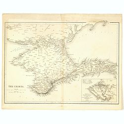
The Crimea.
Map of Crimea and the Sea of Azov. In lower right corner inset map showing Sebastopol region.
- $50 / ≈ €47
Place & Date: London, 1854
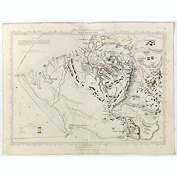
Positions occupées par les armées françaises et anglaises devant Sevastopol.
Map of the French and English armies positions in Sebastopol.Read more about The Crimean War - The Siege of Sevastopol. [+]
- $350 / ≈ €328
Place & Date: Paris, 1854
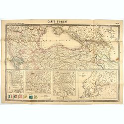
Carte d'Orient par Kraminski ingénieur.
Large map of Orient, with an insert of four maps (Constantinople plan - Map of Europe - Map of Russia - Plan of Baltic sea). With flags in the lower left part. color key ...
Place & Date: Paris, 1854

The Crimea by James Wyld Geographer to the Queen & H.R.H. Prince Albert.
Fourth edition of this folding map of the Crimea. In upper right corner an inset map of the areas around the Black Sea; "The Town & Harbor of Sevastopol with the...
- $375 / ≈ €351
Place & Date: London, 1855

Military map of the countries between Odessa & Perekop with the stations of the Russian forces.
Rare colored linen-backed map showing Russian troop positions and Odessa Batteries. On the inside of the cover a list of "Wyld's list of recent publications : seat o...
Place & Date: London, ca. 1855
Accampamenti, Trinceramenti, ed Operazioni di Assedio...
Detailed plan of the Allied siege of Sebastopol in 1854-1855 during the Crimean War, showing the allied French, English and Turkish positions, and those of the Russians, ...
- $400 / ≈ €374
Place & Date: Naples, 1855
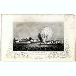
Bombardment of Odessa by the English and French April 22 1854, explosion on the imperial mole . . .
Scene from the Crimea war, showing a bombardment of Odessa, 22nd April 1854 (during Crimean War, 1853-56), by English and French forces, explosion imperial mole (breakwat...
- $30 / ≈ €28
Place & Date: London, 1855
A Complete Map of the Crimea Showing the Military and Carriage Roads with Distances from Various Points of the Western Coast From English & Russian Surveys. . .
Uncommon map of Crimea with (inset maps) Sebastopol Harbor, and Map Showing the relative Position of the Crimea with the Seat of War. From Desilver's "A New Universa...
- $300 / ≈ €281
Place & Date: Pennsylvania, ca. 1856
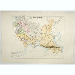
Provincia ecclesiastica di Mohilow nell' Impero Russo (Tav XCII)
A large-format map of Russia, Georgie, Black Sea region with its different dioceses. The map is finely engraved and beautifully colored and was prepared by Girolamo Petri...
- $400 / ≈ €374
Place & Date: Rome, 1858
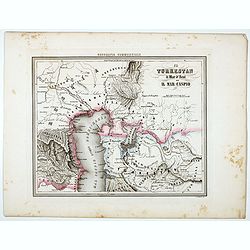
Il Turkestan il Mar d'Aral ed il Mar Caspio.
Uncommon map of Turkestan with the Northern part of the Caspian Sea, prepared by Francesco Costantino Marmocchi. Above the map "Geografia Commerciale". From &qu...
Place & Date: Genova, Paolo Rivara fu Giacomo, 1858

L'escadre alliée bombarde les forts extérieurs de Sébastopol. (18 octobre 1854)
Beautiful Crimean War lithography by Becquet after a painting by Louis Le Breton. The print illustrates the ships "Fort Constantin", "la ville de Paris&quo...
Place & Date: Paris, 1860
Carte de la Crimée / dressée par A. Vuillemin.
Attractive map of Crimea with inset plan of Sevastopol, prepared by Alexandre Aimé Vuillemin (1812-1886). A road system and the ferry lines are drawn in.Engraved by Jaco...
- $300 / ≈ €281
Place & Date: Paris, ca. 1860
Sebastopol.
Steel engraving of the harbour at Sebastopol in the Ukraine published by James Virtue around 1860.
- $45 / ≈ €42
Place & Date: London, 1860
Russia in Europe Part VIII with index map.
Very detailed steel engraved map of the region north of the Black Sea, Podolia, Bessarabia, Kherson, Iekaterinoslav, Taurida, Krimea. Relief shown by hachures.The map is ...
- $150 / ≈ €140
Place & Date: London, Edward Stanford, 1864
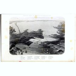
Birds-eye view of the Straits of Kertch & Sea of Azoff.
Steel engraving of the harbour at Sebastopol and the Straits of Kertch and Sea of Azoff in the Ukraine published by James Virtue around 1860.Title in upper margin. With a...
- $75 / ≈ €70
Place & Date: London, 1870