Browse Listings
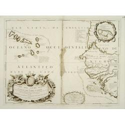
Bocche del Fiume Negro et Isole di Capo Verde.
Double-page engraved map of the Cape Verde Islands and part of the coast of Senegal, with large decorative cartouche. One with inset of the island Goree. During three cen...
Place & Date: Venice, 1690

Le Duché d'Aiguillon Tracé Par le Sr. Du Vall.
Home of the "Cahors” This AOC is the most famous of the sub-regions and home to the popular variety Malbec. These inky wines have been adored for centuries, especi...
Place & Date: Amsterdam, 1650

Premislia celebris russiae civitas.
RARE only included in part VI of his town book. Bird's-eye of Przemysl in Poland. Frans Hogenberg (1535 Mechelen - Cologne 1590) was a copper engraver and etcher. Georg B...
Place & Date: Cologne, 1618

Isola d'Oleron, nella piaggie occidentali della Francia.
A beautiful and rare map showing île d'Oleron.The remarkable Vincenzo Coronelli (1650-1718), encyclopaedist, geographer, inventor and Doctor of Theology, was citizen of ...
Place & Date: Venice, 1690

Nazareth.
Decorative view of Nazareth, below a decorative cartouche with numbered key and surrounded by 2 cherubins. Taken from a very rare travel book by Anthonius Gonsales, "...
Place & Date: Antwerpen, Michiel Cnobbaert, 1673
![Rama. [Ramah]](/uploads/cache/30789-250x250.jpg)
Rama. [Ramah]
Town plan of Ramah, about 5 miles (8 km) from Jerusalem and near to Gibeah. Below a decorative cartouche with numbered key and surrounded by 2 cherubins.Taken from a very...
Place & Date: Antwerpen, Michiel Cnobbaert, 1673
![Via Bethleem. [The route from Jerusalem to Bethlehem ]](/uploads/cache/30800-250x250.jpg)
Via Bethleem. [The route from Jerusalem to Bethlehem ]
The route from Jerusalem to Bethlehem. Below a lettered key. Taken from a very rare travel book by Anthonius Gonsales, "Hierusalemsche Reyse". The book describe...
Place & Date: Antwerpen, Michiel Cnobbaert, 1673

Het Canaal tusschen Engeland en Vranciick.
An eye-catching chart of the Channel.Pieter Goos (ca. 1616-1675) was one of the most important cartographers, engravers, publishers and print sellers of Amsterdam. His wi...
Place & Date: Amsterdam, after 1666

The town & harbour of Sevastopol with the batteries & approaches. . .
Rare colored linen backed map showing the harbour and town of Sevastopol, with soundings. In upper left corner a inset map (65x150mm) of the Black Sea. In bottom part a l...
Place & Date: London, March 27th, 1854

Forteresse Ile Ste Marguerite.
Nice drawing of a stronghold Ste Marguerite. The Île Sainte-Marguerite is the largest of the Lérins Islands, about half a mile off shore from the French Riviera town of...
Place & Date: France, Provence, after 1960