Browse Listings

Carte des découvertes fautes en 1787 dans les Mers de Chine et de Tartarie par les Frégates Françaises la Boussole et l'Astrolabe. . . ée. Feille.
La Pérouse's important large-scale of Northern Japan, Hokkaido, the Kuriles, the tip of Kamschatka, and the northern part of Korea.Showing the track of Perouse from 27 ...
Place & Date: Paris, 1797
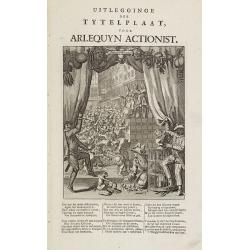
Uitlegginge der tytelplaat voor Arlequyn actionist.
Decorative print. Harlequin stockholder. The engraving (230x180mm.) depicts a kneeling conjuror with cups, balls and cards, Harlequin and Scaramouche drawing back curtain...
Place & Date: Amsterdam, 1720

Constantinopolitanae urbis effigies ad vivum expressa, quam Turcae Stampoldam vocant. A° MDCXXXV.
Large, decorative view of the city of Constantinople, with legend across the bottom. It is beautifully engraved with quaint scenes of everyday life, including hunters wit...
Place & Date: Frankfurt, 1635

Tractus Danubii, Fluminis in Europa Maximi, A Fontibus, Per Germaniam. . .
This is Blaeu’s first map of the Danube and surrounding regions. The Danube River runs through the map from the top left with its headwaters in the German Black Forest ...
Place & Date: Amsterdam, 1634
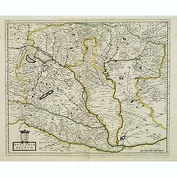
Hungaria regnum.
Detailed map of Hungary. First edition of Sanson's map of the Kingdom of Hungary. Engraved by A. Peyrounin.
Place & Date: Paris, ca. 1640

Donger deel.. derde grietenije van Ooster Goo. . .
Very decorative map of the area north of Dokkum from the Uitbeelding der Heerlijkheit Friesland prepared by Schotanus. With decorative title cartouche lower right mention...
Place & Date: Leeuwarden, F.Halma, 1718

Pascaerte van Brazil en Nieu Nederlandt van Cuorvo en Flores.
A rare chart of the Atlantic Ocean from the first edition of Hendrick Doncker's Zee-Atlas, of which no surviving example is known.Although the idea of its unusual coverag...
Place & Date: Amsterdam, 1658

Lion and Bull made of terracotta.
Very fine terracotta figure of a lion symbolizing the continent of Africa. The Bull symbolizing Europe.The items will be dispatched in 4 wooden crates from Belgium. Pleas...
Place & Date: Netherlandisch , 1780~1800

Nieuwe kaart van het Koningrijk der Nederlanden. . .
Uncommon map of the Netherlands prepared by J.S. Smulders and P. H. Witkamp and lithographed by Z.M. den Koning in the Hague. Dated.Showing The Kingdom of the Netherlands...
Place & Date: The Hague, 1874

Tabula Prima Africa.
The map apart from depicting Morocco also shows southern Spain and the Balearic Islands. In north Africa the map extends eastwards toward modern day Algeria and to the we...
Place & Date: Strasbourg, 1513