Browse Listings
![Ch'onha chido.[Atlas of all under Heaven]](/uploads/cache/44639composition-world-250x250.jpg)
Ch'onha chido.[Atlas of all under Heaven]
A late 18th century Ch'onha chido atlas with 13 woodblock maps showing the World, China, Korea, Japan, Okinawa, and the 8 provinces. The seas are in black.
Place & Date: Korea, ca. 1760
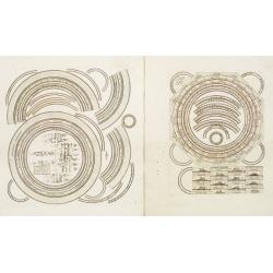
Two sheets for constructing an armillary sphere.
Two sheets for constructing an armillary sphere. Cassini was a geographer and cartographer, but also perspective and architecture carver - one of Giovanni Battista Pirane...
Place & Date: Rome, 1795

Hydrograhica descriptio
This very rare chart is important as the first printed sea chart of the Mediterranean coast of Spain, Gibraltar, also depicting the northern coast of Marocco.Willem Bar...
Place & Date: Amsterdam, W.Blaeu, 1612
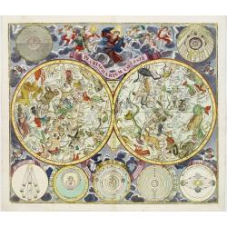
Planisphaerium Coeleste.
Magnificent double hemisphere celestial chart showing the northern and southern sky with constellations in allegorical form derived from Hevelius.A diagram in the upper l...
Place & Date: Augsburg, 1730
![[Page with imaginary towns in Hungary. ] CCLXVIII](/uploads/cache/26932-250x250.jpg)
[Page with imaginary towns in Hungary. ] CCLXVIII
Page with imaginary towns in Hungary (230x225mm.) This leaf is from an edition of Hartmann Schedel's Liber chronicarum or Nuremberg Chronicle. The Chronicle was published...
Place & Date: Nuremberg, 1493

Nuova carta dell' Imperio della Chia e dei Paesi circonvicini. / Nueva carta de l'Impario de la Quina.
The map is of interest for the use of Mar di Corea" and "Mar Setentrionale del Giapone" in the sea between Korea and Japan.Rare early edition of Albrizzi's...
Place & Date: Venice, 1740
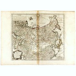
ETATS DE MOSCOVIE.
A detailed map of the Russian Empire West to East from Poland, Finland to the Baring Strait and North to South from China to Spitzbergen. The Siberian coastline is based ...
Place & Date: Paris, 1744

La Saxe Contenant le Routes et les postes. . .
Fine post-route map of Saxony in Germany with a splendidly engraved title cartouche. The map is centered on Leipzig. George Louis Le Rouge was active between 1740 and 178...
Place & Date: Paris, 1756

Habillement de l'Empereur de la Chine & des Dames de son Palais..
This impressive engraving is a wonderful example of Chatelain’s elegant plates.Divided in 3 panels, showing examples of costumes of Chinese ladies and those of the king...
Place & Date: Amsterdam, ca. 1728

Vue de la ville et du château de Heidelberg . . . Ansicht der stadt und des schlosses Heidelberger . . .
Engraving after Louis Charles François de Graimberg-Belleau. Engraved by Ch. Haldennvang.French artist. Son of Gilles-François Belleau Graimberg. Louis Charles Françoi...
Place & Date: Graimberg, Heidelberg, ca. 1840