Wish List
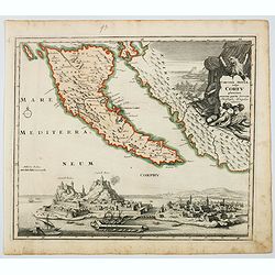
Corcyrae Insula, vulgo Corfu planities unacum parte Greciae.
A scarce map of Greece’s most northerly island, originally drawn by Christoph Weigel, well known as one of the 18th century’s most prolific map makers. To the right o...
Place & Date: Nurnberg, ca 1720
Selling price: $150
Sold in 2021
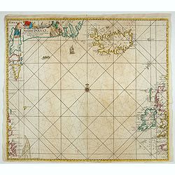
Wassende Graade Kaart van de Noord Oceaan – Van Terra Nova en de Straat Davids en Hudsons tot Hidland en de Westkust van Schotland en Engeland en Bretagne begrypende ook Yrland en Ysland.
Very decorative sea chart by J. Van Keulen, shows the North Atlantic, including Ireland, Iceland, and a portion of the coasts of Greenland, the Faroe Islands, a portion ...
Place & Date: Amsterdam, 1694
Selling price: $300
Sold in 2022
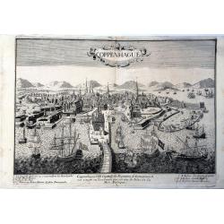
Coppenhague Ville Capitale du Royaume de Danemarck est située en Zeelande qui est une des Isles de la Mer BALTIQUE
Very rare, large decorative view of Copenhagen. The view shows an elaborate waterfront image, with wharves, windmills, shipbuilding, etc. 7 major sites are identified in ...
Place & Date: Paris?, ca 1690
Selling price: $500
Sold in 2023
![[a lot of 14 maps prints of Denmark / Scandinavia] Le Royaume de / Danemark / subdicise en ses principales provences.](/uploads/cache/18385-(6)-250x250.jpg)
[a lot of 14 maps prints of Denmark / Scandinavia] Le Royaume de / Danemark / subdicise en ses principales provences.
An attractive large-format map showing Denmark. Embellished with a large title-cartouche and a cartouche with scales.Newly engraved for the counterfeited edition of the...
Place & Date: Amsterdam, 1692
![[ Lot of 9 maps and plans] Novissima nec non Perfectissima Scandinaviae Tabula](/uploads/cache/18177-(3)-250x250.jpg)
[ Lot of 9 maps and plans] Novissima nec non Perfectissima Scandinaviae Tabula
Frederick de Wit's large and detailled map of Scandinavia. Embellished with a large, decorative title-cartouche.From Frederick de Wit's' Atlas Maior'. Frederik de Wit (16...
Place & Date: Amsterdam, 1690
Selling price: $130
Sold in 2022
In quo sunt Ducatus Holsatia et Slesvicum Insulae Danicae.
Attractive and very detailed map of Denmark and the southern parts of Sweden and Norway, based on an earlier map by Frederick de Wit and even earlier map by Joan Blaeu. T...
Place & Date: Amsterdam, 1690
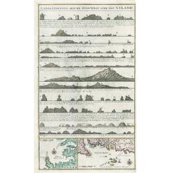
Landkenningen Aen De Zuyd West Syde Van Ysland
A rare cartographic work showing the coastlines of Iceland as they would appear from a ship at sea. The map title and descriptions of the coat are all done in Islandic la...
Place & Date: Amsterdam, 1728
Selling price: $350
Sold in 2023
![[Lot of 3 maps of the Ukrainia] Taurica Chersonesus, Nostra aetate Przecopsca, et](/uploads/cache/20721-(1)-250x250.jpg)
[Lot of 3 maps of the Ukrainia] Taurica Chersonesus, Nostra aetate Przecopsca, et
[Lot of 3 maps of the Ukrainia]- Tavrica Chersonesus, Nostra Aetate Przecopsca, Et Gazara Dictur. (W.Blaeu) 1642 - Taurica Chersonesus. (la presqu'ile ou chersonese p...
Place & Date: Amsterdam, c. 1635
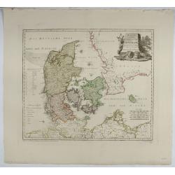
Karte von dem Konigreiche Daenmark.
An attractive map of Denmark. With a decorative title cartouche in the upper right-hand corner and a legend on the left side. Engraved by F. Müller.Franz Johann Josef vo...
Place & Date: Vienna 1796
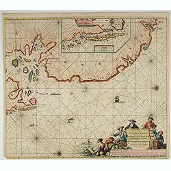
Pas-Kaert van de Cust van Noorwegen Beginnende van Der Neus tot aen Bommel Sond.
Very decorative sea chart of Norway by J. Van Keulen, shows VVest Agder and Rogaland, oriented to the East. Plate number 12 in lower right corner.Inset chart: Pascaertie ...
Place & Date: Amsterdam, 1700
Selling price: $500
Sold in 2022
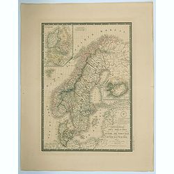
Carte Generale des Royaumes de Suede, de Norvege et de la Danemark.
A fine and detailed large map of the region with insets of Denmark, Faroe Islands, and Iceland. A scroll style title with the embossed royal seal, a keyboard style border...
Place & Date: Paris, 1825
Selling price: $17
Sold in 2021
![[Lot of 3 maps] Uplandia, plus a map of the island of Ruegen by W, Blaeu and the General map of Scandinavia by Reinier & Joshua Ottens.](/uploads/cache/82017-250x250.jpg)
[Lot of 3 maps] Uplandia, plus a map of the island of Ruegen by W, Blaeu and the General map of Scandinavia by Reinier & Joshua Ottens.
An attractive map of Upland with Stockholm. With two nice cartouches. Moses Pitt (d.London,1696), planned to publish together with Janssonius' son-in-law, Janssonius van ...
Place & Date: London, 1680
Selling price: $220
Sold in 2022
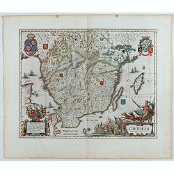
Gothia.
Very decorative map of the southern part of Sweden. The forested topography and lakes are well depicted.The main feature of the engraving is the large title cartouche sur...
Place & Date: Amsterdam, 1645
Selling price: $200
Sold in 2023
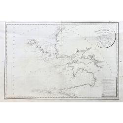
Carte des Cotes de France (environs de Brest) levee en 1816 1817 et 1818
A large sea-chart of the western parts of Finistère in the Bretagne, showing Ouessant, Brest, Plouguerneau, Crozon, Ile de Sein, and Audierne. With fantastic detail ...
Place & Date: Paris, 1823
Selling price: $150
Sold in 2023
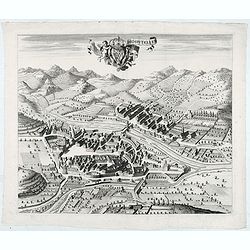
Hospitelum.
Showing in great detail a bird's-eye view of the city of Sospel, located in near from Nice and Monaco.From "Theatrum Sabaudiæ". Engraved by Johannes de Ram.Joa...
Place & Date: Amsterdam, 1682
Selling price: $120
Sold in 2022
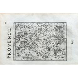
Provincia.
Unusual map of Provence from Camargue to Nice. With many place names, rivers, hills, and islands. Includes Marseille, Aix, Toulon, Avignon, Frejus,... In the style of Ger...
Place & Date: ca 1650
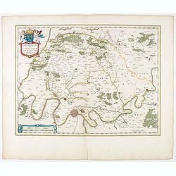
Ager Parisiensis Vulgo L'Isle de France. . .
A very decorative map showing the environs north of Paris with beautiful cartouches. From early on Willem Jansz. Blaeu aimed of publishing an atlas to compete with the H...
Place & Date: Amsterdam, 1644
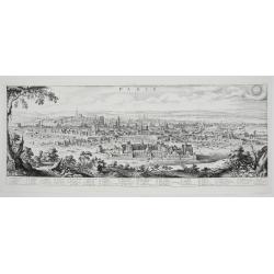
PARYS
Highly detailed Matthaus Merian’s copper engraved uncompleted panoramic view of Paris, France. Paris is shown from Parc des Buttes-Chaumont looking towards the south we...
Place & Date: Frankfurt, 1646
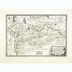
Des Russischen Reiches Statthalterschaften Pleskow, Polozk, Mohilew, Twer, Moskau, Koluga, Wolodimer, Iaroslaw, Tula, Smo, Lensko und Nischgorod. Nro.64
Map of the European part of Russia, centered on Moscow. Published by Franz Johann Joseph von Reilly, 1766-1820, who was a Viennese art dealer who turned to map publishing...
- $150 / ≈ €140
Place & Date: Vienna, 1789
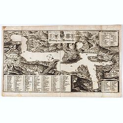
Abbildung der 4. Waldtstätten See.
View of Lake Lucerne and the surrounding land. Detailed indications of all the places and castles present in the region. Representation of mountainous terrain.. Printed f...
Place & Date: Frankfurt, 1654
Selling price: $50
Sold in 2021
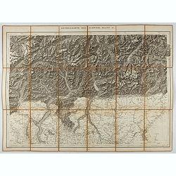
Generalkarte der Schweiz. Blatt IV.
Folding map showing the area from Mainz in the north to Bergamo and Como in the south. The map, engraved by Müllhaupt, is probably part of the 'Topographical Atlas of th...
Place & Date: Bern, 1873
Selling price: $40
Sold in 2023
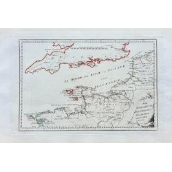
Die Englische Küste dem nördlichen Frankreich gegenüber.
Nice map of the Channel, including London, Ostende, the Channel Isles, and parts of the Bretagne.
Place & Date: Vienna, ca. 1791
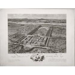
Plan perspective de l'École royale militaire.
A decorative bird's eye view of the complex of the French military school in Paris.
Place & Date: Paris, 1778
Selling price: $75
Sold in 2022
![MIRANDOLA. [Mirandola]](/uploads/cache/47582-250x250.jpg)
MIRANDOLA. [Mirandola]
Rare bird's-eye view of the town of Mirandola. Engraved and published by Donato Bertelli.Some examples are found, in fact, in the work Le vere imagini et descritioni del...
Place & Date: Venice, 1569
Selling price: $250
Sold in 2022
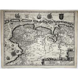
Nieuwe beschrijvige van oost en west Vrieslant ...
Depicted are Friesland and Groningen (NL) and Ost-Friesland (DE).Titel in an cartouche with roll work, a putto and a cock at bottom right in Latin ('Nova description orie...
Place & Date: Amsterdam, 1617
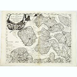
Contado di Zelanda. . .
A most attractive and decorative map of Zeeland by Vincenzo Coronelli. An elaborate title cartouche garlanded with intertwined flowers and dedicated to Vincenzo Caualli. ...
Place & Date: Venice, 1692
Selling price: $110
Sold in 2022
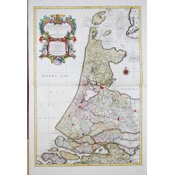
Le Comté De Hollande dressé sur les Memoires les plus Nouveaux
Alexis-Hubert Jaillot (1632-1712), French cartographer. He joined the Sanson heirs and redrew Nicolas Sanson's maps on a larger scale. 'Atlas Nouveau' (1674), sea-atlas '...
Place & Date: Amsterdam, 1696
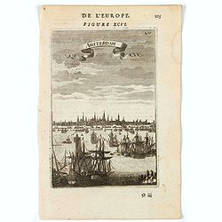
Amsterdam.
A charming view of Amstderdam. Title in curtain draped at top. French text on verso.From the original 1683 text edition of "Description d'Univers. . ." by Allai...
Place & Date: Paris, 1683
Selling price: $30
Sold in 2022