Laurent Fries
Lorenz (Laurent) Fries was born in Alsace in 1490 or thereabouts, describing himself on one occasion as from Colmar. He studied medicine at university, or rather at universities, as he seems to have had a peripatetic education, apparently spending time at the universities of Pavia, Piacenza, Montpellier and Vienna.
Having completed his education, Fries established himself as a physician at a succession of places in the Alsace region and finally settled in Strasbourg in about 1519.
By this time, Fries met the Strasbourg printer and publisher Johann Grüninger, an associate of the St. Die group of scholars formed by, among others, Walter Lud, Martin Ringmann, and Martin Waldseemuller. Grüninger.
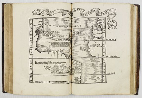
Fries also prepared three new maps for the Geographie: maps of South-East Asia and the East Indies, China and the World, but the geography of these derives from Waldseemuller's world map of 1507.
Lorenz (Laurent) Fries was born in Alsace in c. 1490. He studied medicine at university and established himself as a physician in France before settling in Strasbourg in about 1519. There, Fries met the printer and publisher Johann Grüninger, an associate of the St. Die group of scholars formed by, among others, Martin Waldseemüller. For the next five years, from about 1520 to about 1525, Fries worked in some capacity as a cartographic editor for or with Grüninger, exploiting the material that Waldseemüller had created from Ptolemy. Unfortunately, there is little evidence to help gauge the exact nature of the relationship.
Fries' first venture into mapmaking was in 1520; that is the date found on a map of the World, bearing his monogram. The map was a reduction of Waldseemüller's wall-map of the World, published in 1507. The major project Fries and Grüninger worked on was a new edition of Ptolemy's Geographia, first published in 1522. Fries evidently edited the maps, in most cases simply reducing the equivalent maps from the 1513 edition of the Geographie Opus Novissima. Fries also prepared three new maps for the Geographia: maps of South-East Asia and the East Indies, China and the World, but the geography of these derives from Waldseemüller's world map of 1507.
In 1525, Fries was forced to move on as he had exhausted the existing body of Waldseemüller's works. For whatever reason, his departure marks the end of his cartographic work, and he again turned to writing medical textbooks, which occupied him until he died in 1531 or 1532. The 1535 and 1541 editions of Fries’ Geographia are printed posthumously.
Karrow noted "Grüninger had high hopes for this edition, one of the grandest products of his press in a period when it was not known for producing grand books. The edition suffered, however, from a great many textual errors.
Nevertheless, the book sold well enough to justify a new edition three years later..."
Instead, it would appear that Grüninger sought to recoup his investment by preparing an improved edition. To this end, he sought the assistance of Wilibald Pirkheimer to re-edit the text, using the notes of Johannes Regiomontanus.
The new edition was ready in 1525. As Karrow notes, the press-work was not of a high standard, and Pirckheimer was generally dissatisfied with the finished book.
After Grüninger died in 1531, the business was continued by his son Christoph, who seems to have sold the materials for the Ptolemy to two Lyons publishers, the brothers Melchior and Gaspar Trechsel, who published a joint edition in 1535, before Gaspar Trechsel published an edition in his own right in 1541.
Michael Servetus
Moving to Lyon under the name Villanovanus, Servetus edited scientific works and published a translation of Ptolemy’s Geographia. About 1534 a rendezvous was arranged with John Calvin in Paris to discuss theological questions, but Servetus failed to arrive.
Servetus and Calvin
Two editions of Laurent Fries' atlas were edited by Michael Servetus In those difficult times, Servetus was accused of heresy. One piece of evidence used against him was a passage on the reverse of the modern map of the Holy Land, which said that "Palestine was not such a fertile land as was generally believed, since modern travelers reported it barren". Unfortunately, this not Servetus' original view, but was a passage repeated from the 1522 edition.
This charge seems to have counted against Servetus for, when he was burnt at the stake, Calvin ordered that copies of the book should be burnt with him.
Fortunately, it seems that Calvinist authorities may only have burnt a few token copies!

