Browse Listings in Map Types > Curiosities general
Representation symbolique et ingenieuse projettee en Siege et en Bombardement, comme il faut empecher prudemment les attaques de L'Amour./ Symbolische Sinnreiche in einer Belagerung u. Bombardirung entworffene Vorstellung wie man den anfallen und versuchu
Copper engraved map with old hand-coloring; overall size 54 x 63 cm; plate size 50 x 58 cm. A unique opportunity to purchase a rare fantasy map by Seutter, depicting a ba...
Place & Date: Augsburg, ca. 1730
Selling price: $1000
Sold in 2016
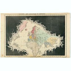
Accurata Utopiae Tabula das ist der Neu entdeckten Schalck Welt. . .Schlarraffenlandes. . .
Schlarraffenland is the German Fool's Paradise, a land of vice and debauchery, from a satire by Hans Sachs in the 16th century. Also, despite the name of Utopia stated in...
Place & Date: Nuremberg, 1730
Selling price: $740
Sold in 2017
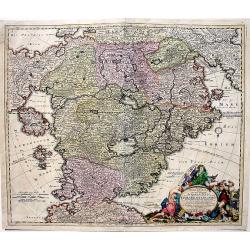
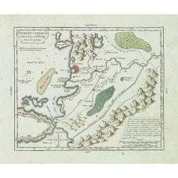
Carte du Paradis Terrestre Suivant le Systeme de Mr. Huet et Execute par P. Starck-man,
Eden, or Paridis Terrestre, along the Gehon River, with Mt. Ararat on top of which rests the Arche de Noé, plus the Tigris and Euphrates Rivers, Babylon, Jerusalem, Syri...
Place & Date: Paris, Emery, Saugrain, Pierre Martin, 1730
Selling price: $120
Sold in 2016
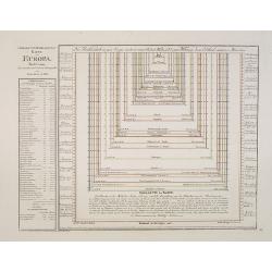
![Mappa geographiae naturalis sive Tabella Synoptica...[guide to the mapmaker's art]](/uploads/cache/82682-250x250.jpg)
Mappa geographiae naturalis sive Tabella Synoptica...[guide to the mapmaker's art]
This is a rare cartographic curiosity designed to illustrate the map drawing process. It consists of an imaginary map with a variety of cultural, geographical, and physic...
Place & Date: Augsburg, 1730
Selling price: $225
Sold in 2019
![Atlas Methodicus Explorandis Juvenum... [Uncut Printing House Sheet]](/uploads/cache/84444-250x250.jpg)
Atlas Methodicus Explorandis Juvenum... [Uncut Printing House Sheet]
A large printing house leaf from Baptist Homann's work "Atlas Methodicus Explorandis Juvenum...", Nuremberg ca 1730. Including the title page and two maps.
Place & Date: Nuremberg, ca. 1730
Selling price: $600
Sold in 2020
Accurata Utopiae Tabula das ist der Neu entdeckten Schalck Welt. . .Schlarraffenlandes. . .
Despite the name in the title (Utopia), this exceptionally decorative, large map doe not depict Thomas More's ideal society: Schlarraffenlandes is the German Fool's Parad...
Place & Date: Nuremberg, 1730
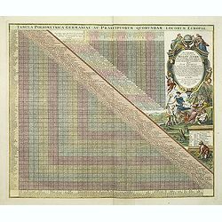
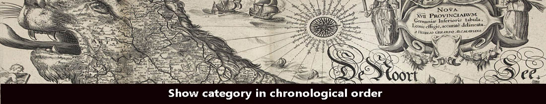
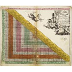
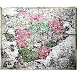
Tabula Poliometrica Germaniae ac Praecipuorum Quorundam Locorum Europae. Neu vermehrter curioser Meilen-Zeiger der vornehmsten Staedte in Europa besonders. . .
Decorative table of distances between major European cities, dated 1731. In the 18th century this type of distance tables where useful for calculating the cost for sendin...
Place & Date: Nuremberg, after 1731
Selling price: $171
Sold in 2011
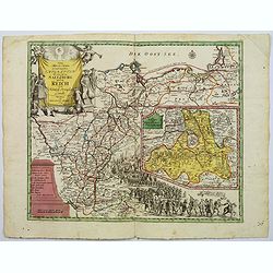
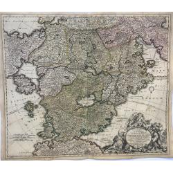
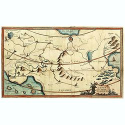
Richtige Marsch Carten der Saltzburgischen Emigraten oder deren Zug aus Saltzburg durch das Reich in die Konigl. Preusisch Lande.
An scarce and interesting historical map by Peter Conrad Monath, covering the 'Great Emigration' that came about on the 31st October 1731, after the (then) Archbishop of ...
Place & Date: Nuremberg, 1732
Selling price: $600
Sold
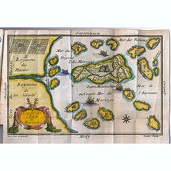
Carte de l'Isle du Mariage. (included in Almanach du Mariage Pour l'Année 1733
This guide book includes a very fine cartographic curiosity: "Carte de l'Isle du Mariage" (map of the wedding island.)Love and marriage have always been among t...
Place & Date: Paris, C. Guillaume, 1733
Selling price: $1306
Sold in 2012
Curjoser Statt-Zeiger der vornemsten ort in Teutschland,..
Engraved by J.B.Homann and published by David Funck. Decorative table of distances between major European cities.
Place & Date: Nuremberg 1742
Selling price: $100
Sold
Introduction à la conoissance et à l'usage des cartes.
This copper engraved map is a guidance on how to use the maps in his "Atlas portatif, universel et militaire, composé d'après les meilleures cartes, . . .".In...
Place & Date: Paris, c. 1745
Selling price: $51
Sold in 2013
Kurz verfasste Kinder Geographie in acht und vierzig Sectionen eingetheilt und den benötigten Charten versehen.
Second edition of the German translation of the "Géographie des Enfans." with map of Paradise.The atlas includes 8 maps, engraved by Sebastian Dorn, in full co...
Place & Date: Nuremberg, Michael Arnold, 1746
Selling price: $3400
Sold in 2012
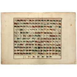
Les PAVILLONS des Mer du Monde Nouvellement Corriges.
A rare sheet with 192 maritime flags of nations and provinces with French names. With many interesting flags, like the one of Mallorca, Corsaires, Constantinople, Ragusa,...
Place & Date: Paris, 1746
Selling price: $120
Sold in 2020
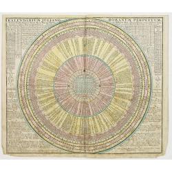
Kalendarium Juliano-Romanum Perpetuum,..
Calendarium.
Place & Date: Augsburg 1750
Selling price: $100
Sold
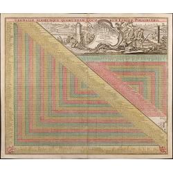
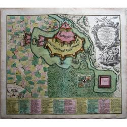
Germaniae Aliorumque Quorundam Loco-rum Europae Poliometria
Distance table from L.C. Lotter, with nice cartouche and explanation of usage.
Place & Date: Augsbourg, 1750
Selling price: $140
Sold in 2009
ACCURATA UTOPIAE TABULA. . .
A scarce, large map of Utopia land on the model that Pieter Schenk originally published in his Atlas contractus in ca 1700. Schlaraffenland is the imaginary land of idlen...
Place & Date: Not known, ca 1750
Selling price: $590
Sold in 2019
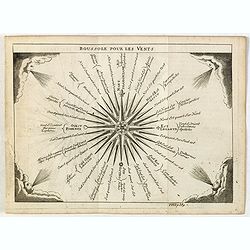
Boussole pour les Vents.
Attractive small print of a compass rose with decorative wind heads at each corner. Published in "Nouveau traité de geographie par M**** ", published by La veu...
Place & Date: Paris, 1752
Selling price: $25
Sold in 2015
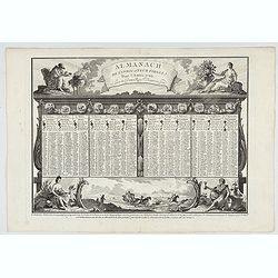
![[Perpetual Almanac.]](/uploads/cache/48405-250x250.jpg)
[Perpetual Almanac.]
An unusual European mid-18th-century Perpetual Almanac made of cardboard and paper printed with polychrome decoration. When made, it must have been quite an instrument, h...
Place & Date: Nuremburg, ca. 1760
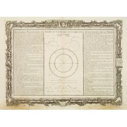
Définitions Préliminaires des Termes de Géométrie Nécessaires..
Decorative map illustrating the geometrical figures at the basis of geometry.Left and right a box containing the basic concepts of geometry.Prepared by Buy de Mornas, who...
Place & Date: Paris 1762
Selling price: $41
Sold
Almanach de l'indicateur fidele pour l'année 1766.
Engraved page of Desnos almanac.
Place & Date: Paris, ca. 1766
Selling price: $175
Sold in 2022
Carte du Chemin d'Amour.
Among the allegorical maps of early modern times, those relating to romantic attachments, sexual relationships and marriage have long excited curiosity among students of ...
Place & Date: France, ca. 1772
Selling price: $400
Sold in 2021
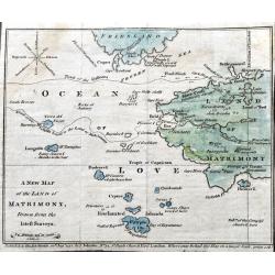
A New Map of the Land of Matrimony, drawn from the latest Surveys.
A very rare satirical map of the Ocean of Love, filled with humorous place names such as Brides Bay, Divorce Island, Rocks of Jealousy,...). The compass rose shows indiff...
Place & Date: London, 1772
Selling price: $290
Sold in 2021
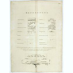
[ Key page
Copper engraved page showing the key references for using the charts in the "Atlantic Neptune". In lower part "Scale of the coasting charts, and Scale of t...
Place & Date: London, 1778
Selling price: $500
Sold in 2019
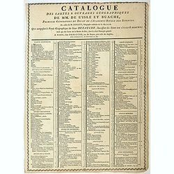
Catalogue des cartes & ouvrages geographiques de MM. DE L'ISLE ET BUACHE
Broad side sheet with on both side a listing of the geographical works of Buache. The sheet also lists the prices of the maps and atlases. The most expensive being the &q...
Place & Date: Paris, ca. 1780
Selling price: $150
Sold in 2023
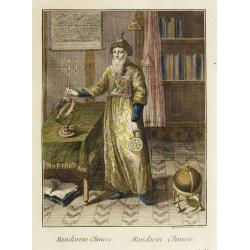
Mandarino Chinese. - Mandarin Chinois.
Hand-colored engraving by Teodoro Viero (1740-1819), a famous venetian 18th century artist who engraved and published numerous plates after artists including Tiepolo, Gra...
Place & Date: Venice, ca. 1781
Selling price: $300
Sold in 2008
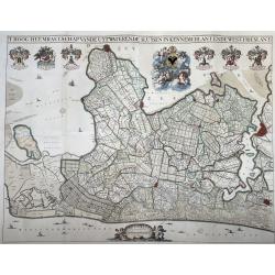
T Hoogh-Heemraetschap van de Uytwaterende Sluysen in Kennemerlant ende West-Frieslant’
A very large format wall map of the province of North Holland made and published for the district water board of Kennemerland and West Friesland, on four leaves, combined...
Place & Date: Amsterdam, 1781
Selling price: $1100
Sold in 2021

Columbus Presenting an Account of His Discovery of America to the King and Queen of Spain.
Christopher Colombus (1451-1506) depicted on his knee presenting documents to Carlos II King of Spain after his return after his third voyage in 1498. From “Bankes's N...
Place & Date: London, 1787
Selling price: $109
Sold in 2016
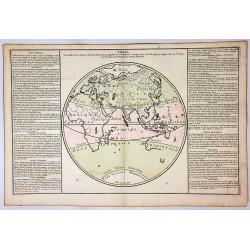
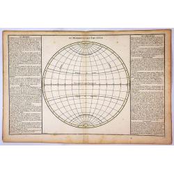
Zones.
A circular map of the Eastern Hemisphere, depicting the zones of the earth, including Torid, Temper and Glacial.To the left and right of the map is French text with remar...
Place & Date: Paris, 1790
Selling price: $28
Sold in 2018
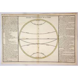
Division Astronomique de la Terre.
An empty circular map of a hemisphere depicting the equator and zones including Tropic, Cancer, Tropic and Capricorn. To the left and right of the map is French text with...
Place & Date: Paris, 1790
Selling price: $8
Sold in 2018
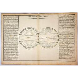
De la Longitude et de la Latitude.
Two empty circular maps of hemispheres depicting the Longitude and Latitude. To the left and right of the map is French text with remarks and descriptions of the map. It ...
Place & Date: Paris, 1790
Selling price: $1
Sold in 2018
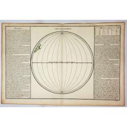
Suite de Longitude.
A circular map depicting the Equator and lines of Longitude. To the left and right of the map is French text with remarks and descriptions of the map. It is from “Geogr...
Place & Date: Paris, 1790
Selling price: $17
Sold in 2019
Du Meridien et de L'Equateur.
A circular map depicting the Equator and Tropic of Cancer and Capricorn. To the left and right of the map is French text with remarks and descriptions of the map. It is f...
Place & Date: Paris, 1790
Selling price: $20
Sold in 2018
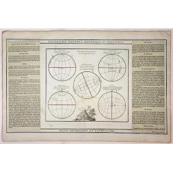
Lecon Methodique et Elementaire.
Five circular maps showing the position of various people on the earth. The map features a vignette at the centre bottom. To the left and right of the map is French text ...
Place & Date: Paris, 1790
Selling price: $8
Sold in 2018
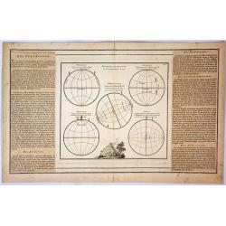
Position Respective des Peuples de la Terre.
Five circular maps showing the position of various people on the earth. The map features a vignette at the centre bottom. To the left and right of the map is French text ...
Place & Date: Paris, 1790
Selling price: $50
Sold in 2019
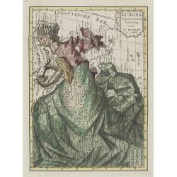
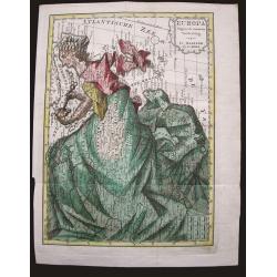
Europa volgens de nieuwste verdeeling.
Uncommon curiosity, depicting Europe as a regal queen but with an interesting twist and political commentary. This anti-Napoleonic image demotes Europa from a virgin-quee...
Place & Date: Haarlem, 1794
Selling price: $800
Sold in 2009
Groessen und Bevoelkerungs Karte von Europa..
A thematic presentation of the sizes of the European countries and their number of inhabitants. From the Grosser Deutscher Atlas published by Franz Joh. Jos. Von Reilly. ...
Place & Date: Vienna 1794
Selling price: $130
Sold in 2012
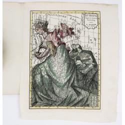
Europa volgens de nieuwste verdeeling.
Uncommon curiosity, depicting Europe as a regal queen but with an interesting twist and political commentary. This anti-Napoleonic image demotes Europa from a virgin-quee...
Place & Date: Haarlem, 1794
Selling price: $350
Sold in 2015
Geheimzinnige toebereidselen tot eene boertige reis door Europa.
The rare book of Arend Fokke Simonsz, published by Francois Bohn and engraved by H. Klockhoff, 152 pages, Dutch text.It includes two maps of Europe, one of them is very u...
Place & Date: Harlem, 1794
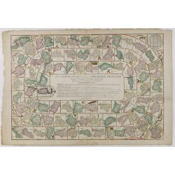
Jeu Géographique de la République française présenté à la Convention Nationale.
Educational game directed by a former professor of geography. It was intended to promote the new French departments, each represented on one of the 83 boxes with its capi...
Place & Date: Paris, Basset, ca. 1795
Selling price: $1300
Sold in 2016
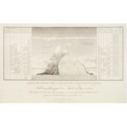
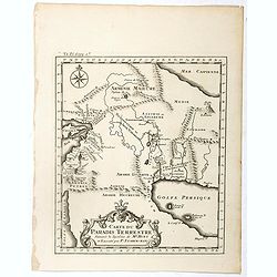
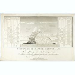
Géographie des Plantes Equinoxiales - Tableau physique des Andes et pays voisins..
''Physical Portrait of the Andes and adjacent lands'', around the Chimborazo and Cotopaxi volcanoes, in Equador.With local vegetation illustrates pictorially on the left ...
Place & Date: Paris, 1805
Selling price: $750
Sold in 2009
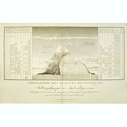
Géographie des Plantes Equinoxiales - Tableau physique des Andes et pays voisins..
"Physical Portrait of the Andes and adjacent lands", organized around the Chimborazo and Cotopaxi volcanoes, in Ecuador.With local vegetation illustrates pictor...
Place & Date: Paris, 1805
Selling price: $1250
Sold in 2014
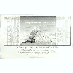
Géographie des Plantes Equinoxiales - Tableau physique des Andes et pays voisins..
"Physical Portrait of the Andes and adjacent lands", organized around the Chimborazo and Cotopaxi volcanoes, in Ecuador.With local vegetation illustrates pictor...
Place & Date: Paris, 1805
Selling price: $850
Sold in 2015
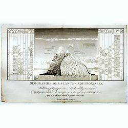
Géographie des Plantes Equinoxiales - Tableau physique des Andes et pays voisins. . .
"Physical Portrait of the Andes and adjacent lands", organized around the Chimborazo and Cotopaxi volcanoes, in Ecuador.With local vegetation illustrates pictor...
Place & Date: Paris, 1805
Selling price: $1250
Sold in 2018
Géographie des Plantes Equinoxiales - Tableau physique des Andes et pays voisins..
"Physical Portrait of the Andes and adjacent lands", organized around the Chimborazo and Cotopaxi volcanoes, in Ecuador.With local vegetation illustrates pictor...
Place & Date: Paris, 1805
Selling price: $1250
Sold in 2021

Géographie des Plantes Equinoxiales - Tableau physique des Andes et pays voisins. . .
Physical Portrait of the Andes and adjacent lands", organized around the Chimborazo and Cotopaxi volcanoes in Ecuador.With local vegetation is illustrated pictoriall...
- $1000 / ≈ €936
Place & Date: Paris, 1805
![[Part of a wall map of Hungary].](/uploads/cache/42560-250x250.jpg)
[Part of a wall map of Hungary].
The Upper left corner of the large folding wall map of Hungary was prepared by Ignac Müller and published first in 1769. The map was made for official use and was kept ...
Place & Date: Vienna, T.Mollo, 1769 - 1807
Selling price: $75
Sold in 2023
La France au commencement de la 3.eme Race..
UNIQUE: with paragraph of the creator of the map Adrien Hubert Brué (1786-1832). The map is a proof with color corrections marked in brown ink by Adrien Hubert Brué.
Place & Date: Paris 1820
Selling price: $180
Sold in 2010
A fine collection of 10 printed game boads, some with cartographical subjects.
The most common game-play set up, used in board games even today, comes from an Italian game known as Goose, which originated in the late 1500s. This game, popular all ov...
Place & Date: Several publishers, 1660 - 1820
Selling price: $8600
Sold in 2014
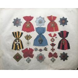
Russie Les Ordres Impériaux et Royaux et Marques d'honneurs
Extremely large, very decorative list of the medals and decorations of Russia. From an exceptionally rare lithographic work of Sperber and Herwig, printed in colors by He...
Place & Date: Deutschland, ca 1820
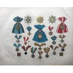
Russie Les Ordres Impériaux
Extremely large, very decorative list of the medals and decorations of Russia. From an exceptionally rare lithographic work of Sperber and Herwig, printed in colors by He...
Place & Date: Germany, ca 1820
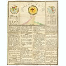
Chart of the rise & progress of christianity.
A very unusual folding sheet with in top double hemisphere hand colored world map with a note saying : In the map of the World, those parts colored RED, are inhabited by...
Place & Date: London, after 1823
Selling price: $550
Sold in 2016
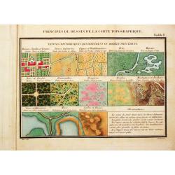
Principes du Dessin et du Lavis de la Carte Topographique.
8vo, oblong, 92 pp, leather (a bit chafed), back gold-stamped. With 3 folding tables and 9 (8 hand-colored) plates.Important instruction book on the drawing and coloring ...
Place & Date: Paris, 1825
Selling price: $1500
Sold
![[Map of Martrimony]](/uploads/cache/42145-250x250.jpg)
[Map of Martrimony]
A rare anonymous early 19th century manuscript map of Matrimony. Among the many names are Rocks of jealousy, Sea of flirtation, P. of proposal, Kingdom of suspense, Land ...
Place & Date: ca. 1800 - 1825
Selling price: $500
Sold in 2019
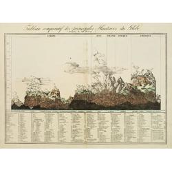
Tableau comparatif des principales hauteurs du globe. D'apres A.M. Perrot.
Lithography depicting comparative front views of the world's tallest mountains, divided in adjacent sections according to the countries. At the bottom an exhaustive key l...
Place & Date: Brussels 1827
Selling price: $250
Sold
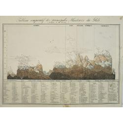
Tableau comparatif des principales hauteurs du globe. D'apres A.M. Perrot.
Lithography depicting comparative front views of the world's tallest mountains, divided in adjacent sections according to the countries. At the bottom an exhaustive key l...
Place & Date: Brussels, 1827
Selling price: $100
Sold in 2009
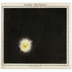
B.C. 2348. The deluge.
Plate from "An historical atlas: in a series of maps of the world as known at different periods constructed upon a uniform scale and colored according to the politic...
Place & Date: London, 1830
Selling price: $160
Sold in 2020
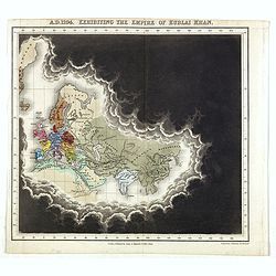
A.D. 1294. Exhibiting the Empire of Kublai Khan.
Plate from An historical atlas: in a series of maps of the world as known at different periods constructed upon an uniform scale and colored according to the political ch...
Place & Date: London, 1830
Selling price: $100
Sold in 2020
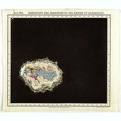
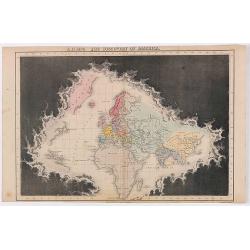
B.C. 301. Exhibiting the partitionof the Empire of Alexander.
Plate from An historical atlas: in a series of maps of the world as known at different periods constructed upon an uniform scale and colored according to the political ch...
Place & Date: London, 1830
Selling price: $120
Sold
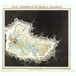
A.D. 912. Dissolution of the Empire of Charlemagne.
Plate from An historical atlas: in a series of maps of the world as known at different periods constructed upon an uniform scale and colored according to the political ch...
Place & Date: London, 1830
Selling price: $100
Sold in 2021
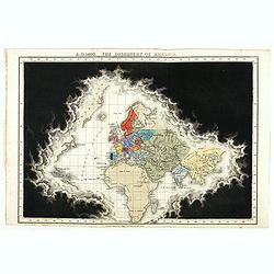
A.D. 1498. The discovery of America.
Plate from An historical atlas: in a series of maps of the world as known at different periods, constructed upon a uniform scale and colored according to the political ch...
Place & Date: London, 1830
Selling price: $300
Sold
A.D. 1498. The discovery of America.
Plate from An historical atlas: in a series of maps of the world as known at different periods, constructed upon a uniform scale and colored according to the political ch...
Place & Date: London, 1830
Selling price: $50
Sold in 2020
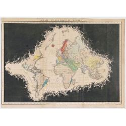
A.D. 1551. At the death of Charles V.
Plate from An historical atlas: in a series of maps of the world as known at different periods, constructed upon an uniform scale and colored according to the political c...
Place & Date: London, 1830
Selling price: $80
Sold in 2020
A.D. 1498. The discovery of America.
Plate from "An historical atlas: in a series of maps of the world as known at different periods, constructed upon an uniform scale and colored according to the polit...
Place & Date: London, 1830
Selling price: $85
Sold in 2022
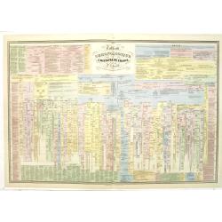
Tableau chronologique de l'histoire de France par P.J Ferrand.
An extensive timetable of France with a wealth of historical information until the year 1811. Prepared by P.J.Ferrand, engraved by Ch. Simon and published by Auguste Loge...
Place & Date: Paris, c.1839
Selling price: $70
Sold in 2020
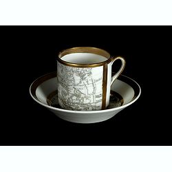
Coffee cup and plate with map design.
The coffee cup has a map of the eastern part of the globe from Europe up to Asia, including China and Korea with a "Mer de Cor(ée)" for the sea between Japan a...
Place & Date: England, ca.1840
Selling price: $300
Sold in 2018
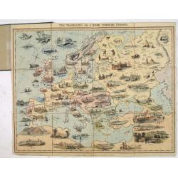
The Travellers or, a Tour Through Europe.
Geographic game, showing a beautiful map of Europe as it does not exist, with the locations of the cities slightly distorted. Prague seems to be North of Dresden and Vien...
Place & Date: London, 1842
Selling price: $1010
Sold in 2013
![[Untitled map of the European countries in a playing grid].](/uploads/cache/32645-250x250.jpg)
[Untitled map of the European countries in a playing grid].
Small, accurate lithographed maps of Europe and Asia, embedded in a square playing grid formed by 100 cells.The 11 cells contain the profile of or a reference to a empero...
Place & Date: France, ca. 1850
Selling price: $75
Sold in 2015
![[Lot of 2 prints] L'Afrique / L'Europe.](/uploads/cache/48130-250x250.jpg)
[Lot of 2 prints] L'Afrique / L'Europe.
A pair of attractive allegorical lithograph prints showing love scenes or courting scenes from two different continents, lifestyle's and cultures. The first shows 'L'Afri...
Place & Date: Paris, ca 1850

Geographische Wercke aus dem Verlag von Justus Perthes in Gotha. Januar 1852.
A very rare publicity leaflet for atlases published by Justus Perthes in 1852. This leaflet is very valuable as it gives in detail the different atlasses published in 185...
Place & Date: Gotha, 1852
Selling price: $150
Sold
![[Map puzzle] Atlas géographique.](/uploads/cache/16637-250x250.jpg)
[Map puzzle] Atlas géographique.
A uncommon geographic Jigsaw puzzle. With a double hemisphere world map, Europe and France. The maps used for the puzzle are geographically sophisticated and well engrave...
Place & Date: Paris 1860
Selling price: $295
Sold
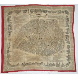
Paris - Foulard Renault, Guide dans Paris / Renault\'s illustrated Paris Guide.
Plan of Paris printed on textile. Surrounded with text and numerous vignettes.
Place & Date: Rouen, ca. 1860
Selling price: $295
Sold in 2008
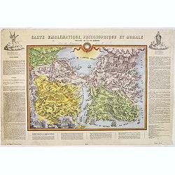
Carte emblématique, philosophique et morale ou Théatre de la vie humaine.
Rare and curious allegorical map, lithographed by G. Lyon Marmorat. The map is surrounded by an explanatory text defining the various terms such as "Empire of Satan&...
Place & Date: Lyon, ca. 1860
Selling price: $2200
Sold in 2012
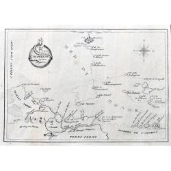
Carte du Voyage Sur la Mer du Monde.
A scarce lithographed map of the Mer Du Monde, showing the track of life with many funny place names in French, such as Ile du Travail, Detroit des etudes, Ile des Desirs...
Place & Date: Paris? ca 1860
Selling price: $100
Sold in 2021
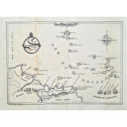
Carte du voyage sur la mer du monde
Curious humorous map in French, showing curious islands in the "Sea of the World" such as: Island of work, Island of desires, Island of greed, Island of injusti...
Place & Date: Lille, ca. 1860
Selling price: $110
Sold in 2023
![[Louis-Philippe teaching geography and mathematics in Reichenau, Switzerland]](/uploads/cache/47439-250x250.jpg)
[Louis-Philippe teaching geography and mathematics in Reichenau, Switzerland]
Lithograph by Chrétien after painting by David showing Louis-Philippe (1773-1850) the last king of France (1830-1848), in Switzerland teaching geography and mathematics ...
- $400 / ≈ €374
Place & Date: Paris, 1864
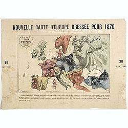
Nouvelle Carte d'Europe dressée pour 1870 / Carte drôlatique d'Europe pour 1870 dressée par Hadol.
Satirical illustration by Paul Hadol showing disposition of power in Europe at the beginning of 1870. Satirical print depicting a map of Europe in which the countries are...
Place & Date: Paris, Imprimerie Vallée, 1870
Selling price: $900
Sold
![[Interior with wallmap.]](/uploads/cache/25617-250x250.jpg)
[Interior with wallmap.]
Scene of a painter and his model set in an old Dutch interior with a wall map of Holland in the back. Etching by Willem Unger after a painting by Joannes Vermeer.Many sev...
Place & Date: Amsterdam, c. 1870
Selling price: $160
Sold in 2008
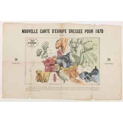
Nouvelle Carte d'Europe dressée pour 1870.
The Franco-Prussian War and The Commune in Caricature 1870-71.Satirical illustration by Paul Hadol showing disposition of power in Europe at the beginning of 1870. Satiri...
Place & Date: Paris, 1870
Selling price: $250
Sold in 2020
La Spagna e Tranquilla. Papagallo No. 4. Anno II.
Satirical plate published in the supplement to the political newspaper charivaric Papagallo / Le Perroquet N. 4, published in Bologna. The title and the caption are in It...
Place & Date: Bologne, 1874

La pericolante ostinata. Papagallo No. 20 Anno II.
Design by Augusto Grossi. Taken from the Italian satirical newspaper Il Papagallo, a satirical magazine founded in January 1873 by Augusto Grossi (1835-1919), which speci...
Place & Date: Bologne, 1874