Browse Listings in Europe > Scandinavia > Finland
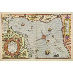
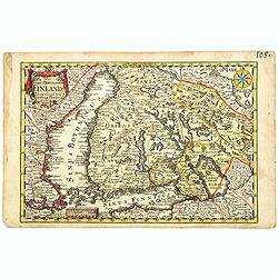
Zhet noterfte ofte Oosterste deel van de Oster Zee, beslooten tegens Rus landt.Lijfflandt, Oost Finlandt . . .
A detailed chart of the coast of Finland. Decorated by a title, scale and descriptive cartouche, a compass rose, several vessels and sea monsters, and depictions of mount...
Date: Leiden, Plantijn, 1585
Selling price: ????
Please login to see price!
Sold in 2008
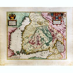
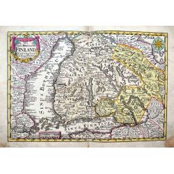
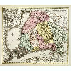
Magnus Ducatus Finlandiae Auct. Andrea Bureo Succo.
The first printed survey map of Finland, composed by the Swedish cartographer Anders Bureus (1571-1661). The map was published in 1662 in the second volume of Joan Blaeus...
Date: Amsterdam, 1660
Selling price: ????
Please login to see price!
Sold in 2015
![Finlande septentr[iona]le et Mérid[iona]le, Nylande, et Tavasthus. . .](/uploads/cache/36574-250x250.jpg)
Finlande septentr[iona]le et Mérid[iona]le, Nylande, et Tavasthus. . .
Map of the southern part of Finland, including Helsinki, Salo, Turku, etc.
Date: Paris, Mariette, 1666
Selling price: ????
Please login to see price!
Sold in 2017
![Finlande septentr[iona]le et Mérid[iona]le, Nylande, et Tavasthus. . .](/uploads/cache/28355-250x250.jpg)
Finlande septentr[iona]le et Mérid[iona]le, Nylande, et Tavasthus. . .
Map of the southern part of Finland, including Helsinki, Salo, Turku, etc.
Date: Paris, Mariette, 1666
Selling price: ????
Please login to see price!
Sold in 2009

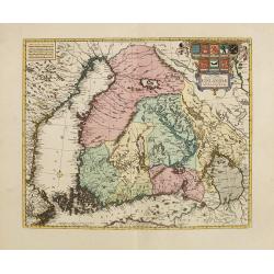
Nova Tabula Magni Ducatus Finlandiae.
The map is based on the archetypal map of the Swede Anders Bure. It is the first map to show the Grand-Duchy of Finland on its own. A remarkably beautiful cartouche displ...
Date: Amsterdam, 1680
Selling price: ????
Please login to see price!
Sold in 2009
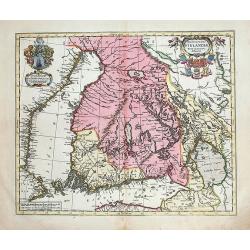
Nova Tabula Magni Ducatus Finlandiae. . .
The map is based on the archetypal map of the Swede Anders Bure. It is the first map to show the Grand-Duchy of Finland on its own. A remarkably beautiful cartouche displ...
Date: Amsterdam, 1680
Selling price: ????
Please login to see price!
Sold in 2010
Magnus Ducatus Finlandiae nova et accurata delineatio.
Very decorative, large map depicting part of the Scandinavian countries, Russia, Finnland. With two decorative cartouches with dedication to J.Schütz. Partly colored usi...
Date: Oxford, 1682
Selling price: ????
Please login to see price!
Sold in 2012
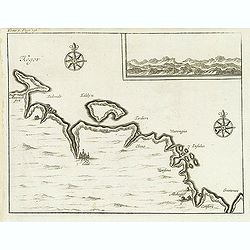
(Kegor.)
Uncommon map of part of the coast along the Barents Sea with the island of Kildin, offshore of the river and town of Cola (Murmansk). Originally made to illustrate Willem...
Date: Amsterdam, E. Roger, 1702
Selling price: ????
Please login to see price!
Sold in 2012
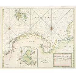
A New Generall Chart of Ye Northern Ocean vitz Norway, Greenland, Finmark, Lapland, Moscovy and Nova Zembla.
Chart of the coasts of Norway, Sweden, Lapland, Russia, including the west coast of Nova Zembla, and part of Greenland. With inset of the island of Podesemsko, with Archa...
Date: London, 1716 - 1740
Selling price: ????
Please login to see price!
Sold in 2009
Das Gros-Hertzogthum Finland. . .
A scarce map shows the southern part of Finland with the cities Oulu, Kajana, Vasa, Helsinki, Kristinestad, Hollola and the now Russian city Wyborg in the historic area o...
Date: Leipzig, ca 1741
Selling price: ????
Please login to see price!
Sold in 2021
(Finland)
One of the earliest detailed maps of Finland, prepared by Joseph Nicolas De L’Isle and included in a later edition of the "Atlas Russicus". The Russian Academ...
Date: Petersburg, 1745
Selling price: ????
Please login to see price!
Sold in 2012
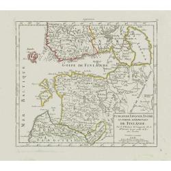
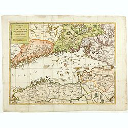
Curlande, Livonie, Ingrie et partie méridionale de Finlande.
Small detailed map showing Latvia, Estonia, part of Russia and southern Finland. With St. Petersburg in the right part.From Atlas Portatif Universel, by Robert de Vaugond...
Date: Paris, later than 1748
Selling price: ????
Please login to see price!
Sold in 2008
Das Gros=Hertzogthum Finland...
Very detailed map of southern Finland until Oulo, extending to include parts of Sweden with Stockholm, Revel (today Tallinn), St. Petersburg, and a part of the White Sea ...
Date: Leipzig, 1749
Selling price: ????
Please login to see price!
Sold in 2017
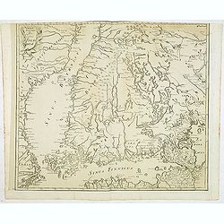
Sinus Finnici Delineatio Geographica ex quam pluriminis subsidiis novissimis stereographice tradita per Dm. Tobiam Majerum. . . Professorem . . .
A fine mid-18th century two sheet map of the Gulf of Finland with its surroundings (Åland, Southern Finland, Inkerinmaa, Estonia, Karjalankannas, Uppland). St. Petersbur...
Date: Nuremberg, 1751
Selling price: ????
Please login to see price!
Sold in 2018
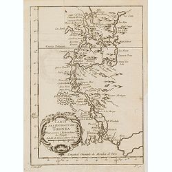
Carte des environs de Tornea. . .
Charming map of the area around Tornio in Finland. Several sounding shown.From Prevost's l'Histoire générale des voyages , the map prepared by J.N. Bellin. Jacques Nico...
Date: Paris, 1758
Selling price: ????
Please login to see price!
Sold in 2017
Magni Ducatus Finlandiae?
The map is based on the archetypal map of the Swede Anders Bure. T.C. Lotter married M. Seutter's daughter in 1740 and succeeded him in 1756. Lotter used the copperplate ...
Date: Augsbourg, 1770
Selling price: ????
Please login to see price!
Sold
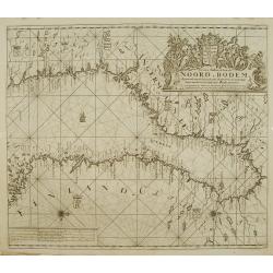
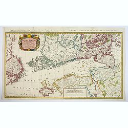
Nieuwe paskaart van de NOORD BODEM.
Latitude scale, compass rose and system of rhumb lines, soundings, anchorage's, etc. A wealth of cities and information appear in the chart. This is an update of an older...
Date: Amsterdam 1771
Selling price: ????
Please login to see price!
Sold
Golfo di Finlandia colle Provincie della Finlandia russa, Carelia, Ingria, Estonia, Nylandia.
Detailed map of the Gulf of Finland, with St. Petersburg in the east. With Helsinki, Tallinn and Haapsalu in Estonia.
Date: Venice, 1780
Selling price: ????
Please login to see price!
Sold in 2014
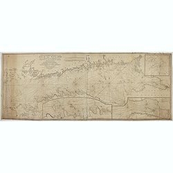
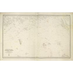
New and correct chart of the Gulf of Finland from the Russian and Swedish surveys Regulated and Ascertained by celestial observations. . .
Large scale blue-backed chart with three insets, . The Bay of Revel. The entrance of Cronstadt. The entrances to Fredrichstamn with Afpo Isles. The main chart has Saint P...
Date: London, Liverpool, 1791
Selling price: ????
Please login to see price!
Sold in 2023
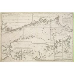
Pass Charta öfver Finska Wiken..
Maritime chart centred on the Gulf of Finland, depicting the opposing coasts of Finland and Russia.With 6 inset plans in the lower part of the map, illustrating enlargeme...
Date: Stockholm 1791
Selling price: ????
Please login to see price!
Sold
Mepkatopckar... (Title in Russian : Baltic Sea east of Helsinki with Kotka and the Islands of Gogland and Moshchny.)
This rare chart of the Baltic Sea east of Helsinki with Kotka and the Islands of Gogland and Moshchny until the Russian coast. Based on the work of Gavril Andreyevich Sar...
Date: Saint Petersburg, 1848
Selling price: ????
Please login to see price!
Sold in 2011
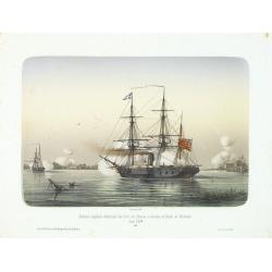
Division anglaise détruisant les forts des Russes à l'entrée du Golfe de Finlande.
Showing two English ships attaching a Russian stronghold in the Gulf of Finland during June 1854. The Crimean War (1854-1856) between Russia on one side and the alliance ...
Date: Paris, 1860
Selling price: ????
Please login to see price!
Sold in 2014
