Browse Listings in Europe > Scandinavia
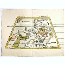
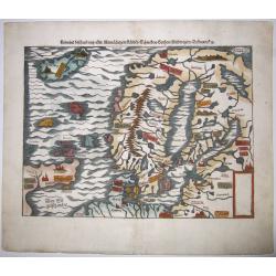
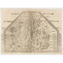
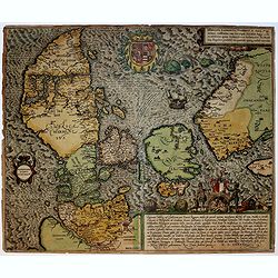
Tabula Moderna Norbegie et Gottie.
Rare woodblock map of Scandinavia published by Waldseemüller, from the first modern atlas, because the 20 new maps in this atlas show all parts of the world based on con...
Place & Date: Strasbourg, Johann Schott, 1513-1520
Selling price: $6000
Sold in 2020
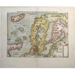
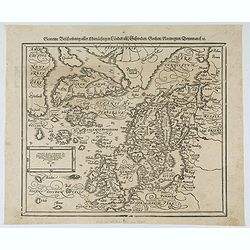
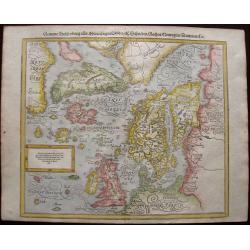
Gemeine Beschreibung Aller Mitnachtigen Lander Schweden, Gothen, Nordwegien, Dennmarck &c.
One of the earliest woodcut maps of Scandinavia. Shows Iceland, Norway, Sweden, Finland, Scotland, Denmark with the North Sea and Baltic Sea. Sebastian Munster's second m...
Place & Date: Basel, ca 1540
Selling price: $325
Sold in 2019
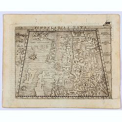
Sconladia Nova.
Gastaldi's modern map of Scandinavia, Iceland, and the Baltic According to Bill Ginsberg the map was "built upon previous publications, in particular, the representa...
Place & Date: Venice, 1548
Selling price: $1100
Sold in 2022
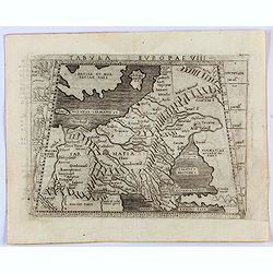
Tabula Europae VIII. (Russia, Ukraine, Baltic, Scandinavia)
Gastaldi's map showing the Baltic in the North and the Black Sea in the south. Based upon Ptolemy.Embellished is a sailing ship, sea monster and several curious animals.I...
Place & Date: Venice, 1548
Selling price: $325
Sold in 2022
Gemeine beschreibung aller Mitnaechtigen Laender, Schweden, Gothen, Nordwegien, Dennmarck, sc.
An early Sebastian Münster's woodcut map of Scandinavia, based on the 'Carta Marina' of Olaus Magnus, 1539. The map includes Norway, Sweden, Finland, Denmark, Iceland, S...
Place & Date: Basel, ca 1550
Selling price: $550
Sold in 2020
![[Lot of 19 leaves of Scandinavia, Greenland, Island]](/uploads/cache/48298-250x250.jpg)
[Lot of 19 leaves of Scandinavia, Greenland, Island]
Nineteen text leaves illustrated with wood block prints and maps relating to Scandinavia, Greenland and Island. From the 1552 Latin text edition of Münster's Cosmographi...
Place & Date: Basel, 1552
Selling price: $155
Sold in 2022
Gemeine beschreibung aller Mitnaechtigen Laender, Schweden, Gothen, Nordwegien, Dennmarck, sc.
An early Sebastian Münster's woodcut map of Scandinavia, based on the 'Carta Marina' of Olaus Magnus, 1539. The map includes Norway, Sweden, Finland, Denmark, Iceland, S...
Place & Date: Basel, 1560
Selling price: $300
Sold in 2021
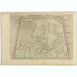
Schonladia Nuova.
Depicting Scandinavia in a trapezoidal projection, being one of the earliest obtainable modern maps of Scandinavia. The map combines Ptolemaic and modern cartographic inf...
Place & Date: Venice, 1561
Selling price: $200
Sold in 2017
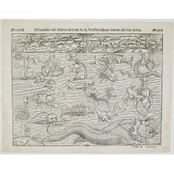
Mörewunder vnd seltzame thier
Spectacular woodcut of mythical land with sea monsters and animals. The monsters were first engraved in the ‘Carta Marina’ of 1539 by Olaus Magnus and have been us...
Place & Date: Basel, 1561
Selling price: $1500
Sold in 2022
![[Southern Scandinavia to central Germany, Netherlands and East England]](/uploads/cache/25014-250x250.jpg)
[Southern Scandinavia to central Germany, Netherlands and East England]
The rare second state is dated 1562, but still lacks the imprint of Camocio. The map has no title and extends from Southern Scandinavia to Central Germany, The Netherland...
Place & Date: Venice, 1562
Selling price: $21200
Sold
(SCANDINAVIE). Monogr. THW (Thomas Weber) dated 1567.
Rare and important map of Scandinavia from Olaus Magnus' Historia Olai Magni gothi archiepiscop upsalensis, de gentium septentrionalium, published in Basel in 1567.The ma...
Place & Date: Basle, 1567
Selling price: $7000
Sold in 2019
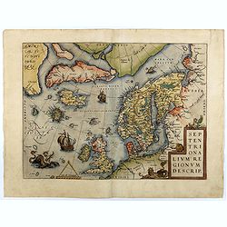
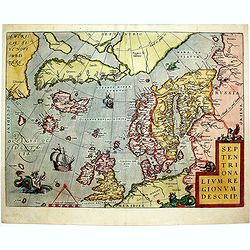
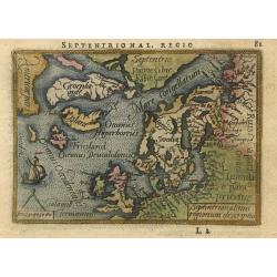
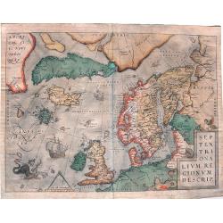
Septentrionalium Regionum Descrip.
Early second state of this influential map of the Arctic, including Scandinavia, Iceland, Greenland and part of the North American continent, includes also the legendary ...
Place & Date: Antwerp, 1571/1573
Selling price: $1750
Sold in 2018
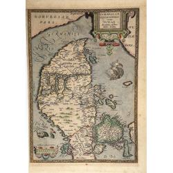
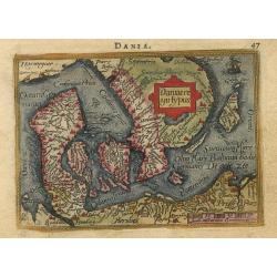
Daniae Tabula...
Striking map of Denmark, extending from the Mechlenberg, Pomerania and Prussian Coastlines to the Norwegian Coastline, and extending north to show Stockholm. from the 157...
Place & Date: Antwerp,1572/1574
Selling price: $500
Sold in 2012
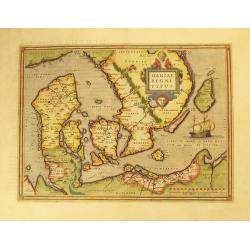
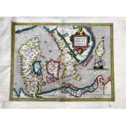
Daniae Regni Typus.
Early decorative map of Denmark, extending from the Mechlenberg, Pomerania and Prussian Coastlines to the Norwegian Coastline, and extending north to show Stockholm. Abra...
Place & Date: Antwerp, 1574
Selling price: $475
Sold in 2017
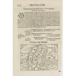
Gotland oder Gothen.
Map of Scandinavia. From his Cosmographia, that great compendium of Renaissance knowledge. An exciting print.Sebastian Münster was born in Nierder-Ingelheim, near Mainz ...
Place & Date: Basle 1550-1580
Selling price: $70
Sold in 2010
![[Map of Scandinavia]](/uploads/cache/91426-250x250.jpg)
[Map of Scandinavia]
Small Scandanvia woodcut map by Sebastian Münster.
Place & Date: Basel, c. 1580
Selling price: $55
Sold in 2010
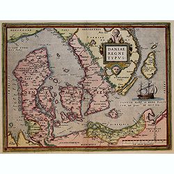
Daniae regni typus.
A very decorative, and nicely colored example of Ortelius' map of Denmark, extending from Schleswig Holstein and Mechlenberg, Pomerania and Prussian coasts to the Norwegi...
Place & Date: Antwerp, ca 1580
Selling price: $310
Sold in 2020
Septentrionalium Regionum Descrip.
This influential map of the Arctic, including Scandinavia, Iceland, Greenland and part of the North American continent, includes also the legendary islands of i.a. Drogeo...
Place & Date: Antwerp, 1584
Selling price: $1950
Sold in 2014
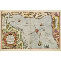
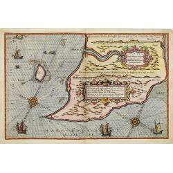
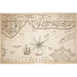
Zhet noterfte ofte Oosterste deel van de Oster Zee, beslooten tegens Rus landt.Lijfflandt, Oost Finlandt . . .
A detailed chart of the coast of Finland. Decorated by a title, scale and descriptive cartouche, a compass rose, several vessels and sea monsters, and depictions of mount...
Place & Date: Leiden, Plantijn, 1585
Selling price: $5000
Sold in 2008
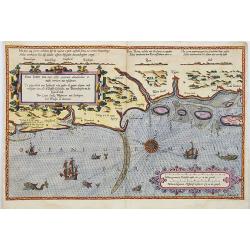
Beschrivingee der zijden op de Belt en Noortzee. . .
A rare Dutch text edition of this early detailed chart of the coast of Jutland and its towns Skagen among others. Decorated by a title and scale cartouche, two compass ro...
Place & Date: Leiden, Plantijn, 1585
Selling price: $1800
Sold in 2022
De gelegentheijt van Jutlandt, mits gaders de gaeten . . Tot dat Eijlandt Silt.
A detailed chart of the Danish coastline, including Tondern and te island Silt. Decorated by a title, scale and a descriptive cartouche, one compass rose, several vessels...
Place & Date: Leiden, Plantijn, 1585
Selling price: $1800
Sold in 2022
Cimbricae Chersonese nunc Iutiae descriptio.
A very decorative, old-colored example of Ortelius' map of Jutland, depicting also Fiona, Alsen, and Langeland. The map is based on the work of Marcus Jordanus, a profess...
Place & Date: Antwerp, 1585
Selling price: $245
Sold in 2021
Zee Caerte vande Sondt..van Denemarcke..
RARE. Very nice chart of Sont and parts of Denmark, centered on Copenhagen.It was published by Dutch cartographer L.J. Waghenaer in his 1586 "Spieghel Der Zeevaerdt,...
Place & Date: Amsterdam 1586
Selling price: $2350
Sold
De Custen van een deel van Denemarken en Swederyck , beginnede va Uuytlte tot Calmer toe. . .
A decorative uncloured chart displaying the North Sea and the coast of Sweden and Denmark. Several vignettes of sea monsters and a ship. It was published by Dutch cartogr...
Place & Date: Leiden, 1586
Selling price: $375
Sold in 2009
Danorum Marca, uel Cimbricum. aut Daniae Regnum..
The oldest preserved map of Denmark of Danish origin. Drawn by Marcus Jordan at the request of Duke Heinrich Rantzau, viceroy of Schleswig-Holstein. It is a new perceptio...
Place & Date: Cologne 1588
Selling price: $950
Sold
Daniae regni Typus
Miniature map covering Denmark including that part of Sweden that was then controlled by Denmark. The map is beautifully engraved with stippled seas and a sailing ship.
Place & Date: Antwerp, 1588
Selling price: $100
Sold
Septentrionalium regionum descriptio
Handsome miniature map based on Ortelius' important map of the Arctic regions with the mythical islands of Drogeo and Frieslant. The map is beautifully engraved with stip...
Place & Date: Antwerp, 1588
Selling price: $260
Sold
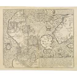
Gemeine Beschreibung aller Mitnachtigen Lander/ alsz Schweden / Gothen / Norwegien / Dennmark &c
Interesting wood block printed map of Europe, Scandinavia, England, Denmark, Norway, Sweden, Iceland, The Baltics, Greenland, and America.The map shows two Greenlands, on...
Place & Date: Basle, 1588
Selling price: $950
Sold in 2014
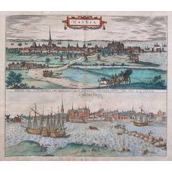
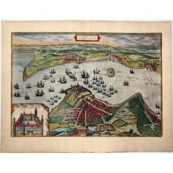
Hafnia vulgo Kopenhagen.
Two fantastic birds-eye views of Copenhagen, one from land and from the seaside showing the harbor. Highly detailed with numerous buildings, windmills, sailing ships, and...
Place & Date: Cologne, ca. 1588
Selling price: $243
Sold in 2015
Danorum Marca, uel Cimbricum. aut Daniae Regnum..
The oldest preserved map of Denmark of Danish origin. Drawn by Marcus Jordan at the request of Duke Heinrich Rantzau, viceroy of Schleswig-Holstein. It is a new perceptio...
Place & Date: Cologne, 1588
Selling price: $1100
Sold in 2016
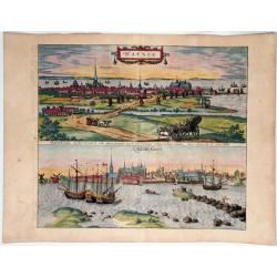
Hafnia vulgo Kopenhagen. (Copenhagen)
Two views of Copenhagen, by Georg Braun & Frans Hogenberg.
Place & Date: Cologne, 1588
Selling price: $350
Sold in 2020
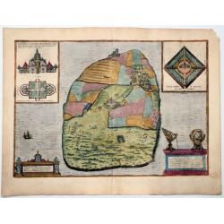
Topographia insulae Hvenae in celebri porthmo regni Daniae, quem vulgo oersunt vocant : effigiata Coloniae 1586 (Hven/Uraniborg - Tycho Brahe)
An antique map showing Uraniborg, which was a Danish astronomical observatory and alchemy laboratory established and operated by Tycho Brahe. It was built c. 15...
Place & Date: Cologne, 1588
Selling price: $625
Sold in 2020
![Helsheborch [on sheet with] Lunden [and] Elbogen [and] Landeskron. (Helsingborg, Lund, Malmö, Landskrona)](/uploads/cache/84389-250x250.jpg)
Helsheborch [on sheet with] Lunden [and] Elbogen [and] Landeskron. (Helsingborg, Lund, Malmö, Landskrona)
Four bird's-eye views of Swedish towns by Braun and Hogenberg : Helsingborg, Lund, Malmö and Landskrona.HELSINGBORG with COMMENTARY BY BRAUN (on verso): "Helsingbor...
Place & Date: Cologne, 1588
Selling price: $1450
Sold in 2020
Freti Danici or Sundt Accuratiss Delineatio.
Bird's-eye view of The Sound with Helsingborg, Landskrona and Elbogen, by Georg Braun and Frans Hogenberg. Inset with a view of Kronenborg Castle.Translation of cartouche...
Place & Date: Cologne, 1588
Selling price: $600
Sold in 2020
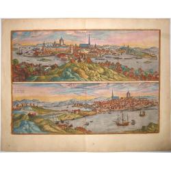
STOCKHOLM - STOCHOLM.
An old, antique map with two bird's-eye/panoramic views(North and South) of Stockholm, by Georg Braun and Frans Hogenberg, after Hieronymus Scholäus. Showing its active ...
Place & Date: Cologne, 1588
Selling price: $1300
Sold in 2021
![Danorum Marca, uel Cimbricum. aut Daniae Regnum. . .[DENMARK]](/uploads/cache/84987-250x250.jpg)
Danorum Marca, uel Cimbricum. aut Daniae Regnum. . .[DENMARK]
The oldest preserved map of Denmark of Danish origin. Drawn by Marcus Jordan at the request of Duke Heinrich Rantzau, viceroy of Schleswig-Holstein. It is a new perceptio...
Place & Date: Cologne, 1588
Selling price: $1850
Sold in 2021
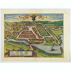
Colding Schloss und Stat.
A bird's eye view of Kolding castle and town from Braun & Hogenberg. The port of Kolding on the Danish Jutland Peninsula is seen in cavalier perspective from the sout...
Place & Date: Cologne, 1589
Selling price: $190
Sold in 2019
Septentrionalium Regionum Descrip.
Influential map of the Arctic. It includes Scandinavia, Iceland, Greenland and part of the North American continent, together with the legendary islands of the north: Dro...
Place & Date: Antwerp, ca. 1590
Selling price: $1200
Sold in 2015
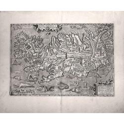
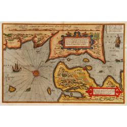
Islandia.
Probably the most famous (and among the most beautiful!) map of Iceland. On the south side an impressive collection of sea monsters. Polar bears on ice flows and volcanoe...
Place & Date: Anwerp, ca 1590
Selling price: $4200
Sold in 2016
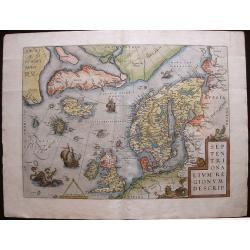
Septentrionalium Regionum Descrip.
A fascinating and important map of the North Atlantic by A. Ortelius in beautiful original colors.
Place & Date: Antwerp, 1590
Selling price: $1400
Sold in 2016