Browse Listings in Europe > Mediterranean & Islands
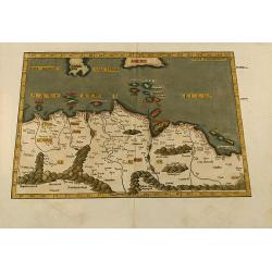
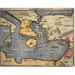
Aphricae tabula secunda continet
Untitled trapezoidal Ptolemaic woodcut map of North Africa. From the 1541 Vienne (Dauphiné) edition of Ptolemy\'s Geographia published by Gaspar Trechsel and sold by H...
Place & Date: Vienne, 1541
Selling price: $500
Sold in 2009
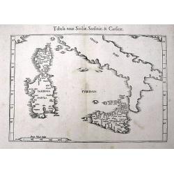
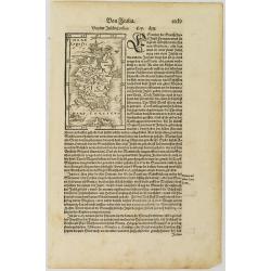
Tabula nova Siciliae, Sardiniae, & Corsicae
An early woodcut Ptolemaic map of Corsica, Sardinia, Sicily, and southern Italy. With several towns and islands named. The active volcano Etna is shown with flames.
Place & Date: Vienne, 1541
Selling price: $120
Sold in 2016
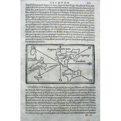
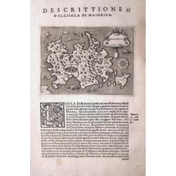
(Balearic Islands: Majorca, Minorca, Ibiza, Formentera)
The first separate printed maps of the Balearics, and the first regional map to name "Catalunya" (Catalonia) on the Spanish mainland! A wood cut page with Ital...
Place & Date: Venice, 1528-1547
Selling price: $450
Sold in 2015
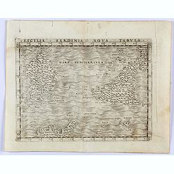
Sicilia Sardinia Nova Tabula.
Gastaldi's modern map of Sicily and Sardinia. From Giacomo Gastaldi's Atlas of 1548 which has been called the most comprehensive atlas, produced between Martin Waldseemü...
Place & Date: Venice, 1548
Selling price: $300
Sold in 2023
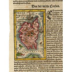
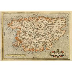
Corsica.
Woodblock map of Corsica surrounded by ships and fierce sea monsters. On a full sheet of German text.
Place & Date: Basle 1562
Selling price: $100
Sold
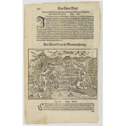
Neapolis. / Tiloi.
Text page with two town views of Naples and "Tiloi". It is a typical woodcut illustration that makes these Münster maps fascinating and sought after by map col...
Place & Date: Basel, 1562
Selling price: $80
Sold in 2008
Corsica.
Nice miniature map of Corsica with monsters and ships in the sea. It is a typical woodcut illustration that makes these Münster maps fascinating and sought after by map ...
Place & Date: Basel, 1562
Selling price: $80
Sold in 2008
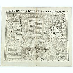
Tabula Siciliae et Sardiniae. (Sicily and Sardinia)
Double-page woodcut Ptolemaic-style map by Sebastian Münster figuring Sicily and Sardinia, published in the edition of Strabo by Henri Petri in 1571."Strabonis reru...
Place & Date: Basle, Henri Petri, 1571
Selling price: $155
Sold in 2018
MAIORCA.
One of the earliest separate maps of Majorca (Mallorca)! First issue from 1572. The map shows major cities and several sea monsters. A compass rose orients the map with s...
Place & Date: Venice, c1572
Selling price: $200
Sold in 2013
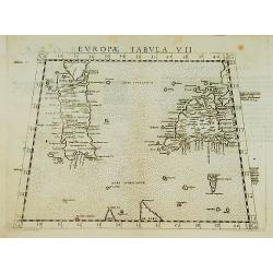
Europae Tabula VII.
Map representing Sardinia and Sicily. Also showing Malta, southern part of Corsica, northern part of Africa and western part of Italy.From La Geografia Di Clavdio Tolomeo...
Place & Date: Venise 1574
Selling price: $130
Sold

Senensis ditionis. . . / Corsica / Marcha Anconae. . .
Three inset maps : on the left the Tuscan region with Sienna upper left, the island of Corsica upper right, and lower right the Ancona region along the coast of the Adr...
Place & Date: Antwerp, 1574-1575
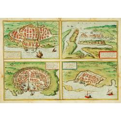
![Calaris [on sheet with] Malta [and] Rhodus [and] Famagusta.](/uploads/cache/33682-250x250.jpg)
Calaris [on sheet with] Malta [and] Rhodus [and] Famagusta.
One sheet with very desirable and early town-plans of four Mediterranean island capitals—Cagliari (Sardinia), Valletta (Malta), Rhodes, and Famagusta (Cyprus). "C...
Place & Date: Cologne, (1572) 1577
Selling price: $550
Sold in 2015
-250x250.jpg)
Melita
One of the first delineations of the island of Malta.
Place & Date: Basel, ca. 1578
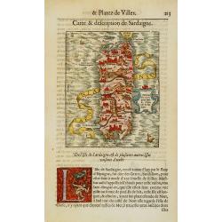
Sardinia insula
Very early and decorative map of Sardinia with in top the southern most tip of Corsica.From his Cosmographia, that great compendium of Renaissance knowledge.Very decorati...
Place & Date: Basel 1580
Selling price: $275
Sold
Corsica.
Early map of Corsica, oriented east to the top.
Place & Date: Antwerp, ca. 1580
Selling price: $480
Sold
![[Lot with 12 maps of the Mediterraneans and Egypt.] Aegypti Recenttior Carthageni / General Karte des Roemischen Reichs](/uploads/cache/83963-250x250.jpg)
[Lot with 12 maps of the Mediterraneans and Egypt.] Aegypti Recenttior Carthageni / General Karte des Roemischen Reichs
A map of the Middle East and the Mediterranean. Taken from 'Algemeine Welthistorie (der Neuern Zeiten)', edited by S.J. Baumgarten, J.S.Semler a.o. Abraham Ortelius...
Place & Date: Antwerp, c. 1580
Selling price: $198
Sold in 2022
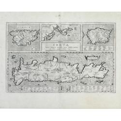
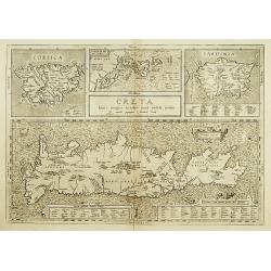
Creta Iouis magni, medio iacet insula ponto.
Fantastic map of islands of the Mediterranean by Ortelius; a large map of Crete is at the bottom half of the sheet, with smaller maps of Corsica, the Greek Islands and Sa...
Place & Date: Antwerp, 1584
Selling price: $200
Sold in 2010
Tafel Der Lender Darin Der Apostel Paulus Geprediget Hat.
The Eastern Mediterranean, from the "Itinerarium Sacrae Scripturae", showing Italy, Sicily, Greece, Cyprus, Asia Minor, the Holy Land and North Africa, with cit...
Place & Date: Magdeburg, 1585
Selling price: $400
Sold in 2014
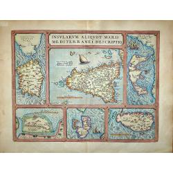
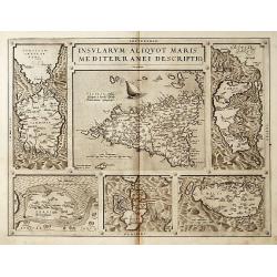
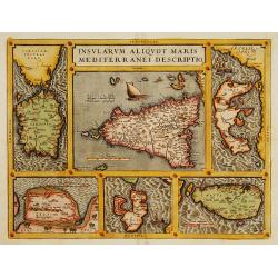
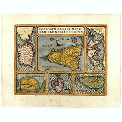
Insularum Aliquot Maris Mediterranei Descriptio.
Insularum Aliquot Maris Mediterranei Descriptio. Cum priuilegio'Sicily, Sardegne, Corfv, Zerbi, Elba, Malta. Six early maps on one sheet. Including the islands of Sicily,...
Place & Date: Antwerp, 1587
Selling price: $650
Sold in 2017
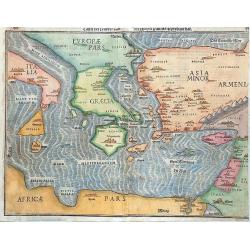
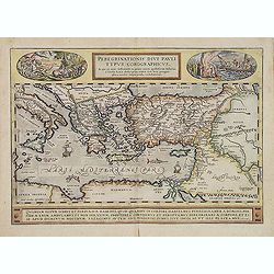
Peregrinationis Divi Pauli Typus Corographicus...
Ortelius's map of Paulus's travels from his Atlas Theatrum Orbis Terrarum. It covers the Mediterranean Sea from Italy and Sicily until the Near East and Egypt, with Cypru...
Place & Date: Antwerp, 1587
Selling price: $180
Sold in 2019
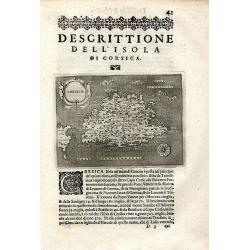
Descrittione Dell' Isola Di Corsica
Rare early map of the French island Corsica and a small part of Sardinia. Published around 1590 in "L'isole piu famose del mondo." Very detailed naming many s...
Place & Date: Padova, ca. 1590
Selling price: $160
Sold in 2009

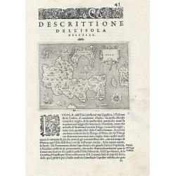
Descrittione Dell' Isola Di Corsica.
Rare early map of the French island Corsica and a small part of Sardinia. Published around 1590 in "L'isole piu famose del mondo." Very detailed map, naming man...
Place & Date: Padova, ca. 1590
Selling price: $180
Sold in 2011
Descrittione dell' Isola dell'Elba.
The map depicts the Italian Mediterranean island of Elba. The map is orientated towards the north-west. From "L'Isole Piu Famose del Mondo", printed in Venice. ...
Place & Date: Venice, 1590
Selling price: $150
Sold in 2019
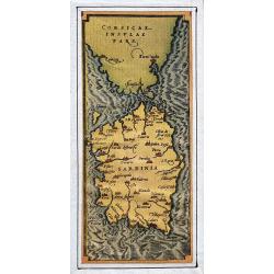
Corsicae insulae pars / Sardinia
Small map of southern Corsica and all of Sardinia, which is a part of Ortelius' map Insularum Aliquot. Superbly engraved and with fine detail.
Place & Date: Antwertp, ca. 1590
Peregrinationis divi Pauli typus corographicus
Hand colored map of the Eastern Mediterranean by Abraham Ortelius. Covering the Mediterranean Sea between Israel and Sicily with Cyprus, Italy, Greece and Turkey. With tw...
Place & Date: Antwerp, 1592
Selling price: $700
Sold in 2010
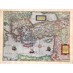
Natoliam Moderni dicunt tam partem quam Asiam minrem appelauere veteres (with Cyprus)
Engraved by Van Deutecum, this is a spectacular example of the 1593 edition of the very rare De Jode's map of the Eastern Mediterranean and Asia Minor. It has two title c...
Place & Date: Antwerp, 1593
Selling price: $2900
Sold in 2014
Creta Iouis magni../Corsica../ Sardinia..
Islands are shown with place names and important locales as they existed in the Classical Period. Ortelius mentions as his classical sources Strabo, Palenses, Athenaeus, ...
Place & Date: Antwerp 1595
Selling price: $270
Sold
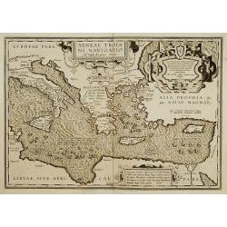
Aeneae Troiani navigatio..
After the destruction of Troy, Aenaeas is reported to have roamed the seas for seven years, as described in the writings of Xenophon, Ovidius, Lycrophonous, but most exte...
Place & Date: Antwerp 1595
Selling price: $320
Sold
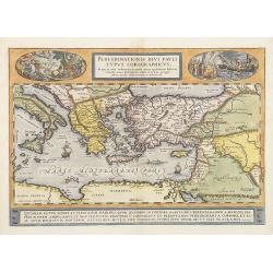
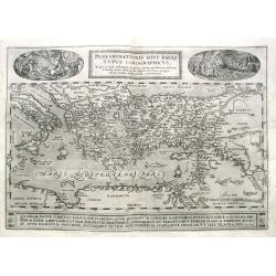
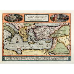
Peregrinationis Divi Pauli Typus Corographicus . . .
A splendid map depicting the travels of Paulus. With two fine scenes in top. Showing the countries along the Mediterranean, including Cyprus and Italy. Based on Mercator'...
Place & Date: Antwerp, 1595
Selling price: $1300
Sold
Peregrinationis Divi Pauli Typus...
A splendid map depicting the travels of Paulus. With two fine scenes in top. Showing the countries along the Mediterranean, including Cyprus and Italy. Based on Mercator'...
Place & Date: Antwerp, 1595
Selling price: $600
Sold in 2014
Tafel der Lender / darin der Apostel Paulus geprediget hat.
Woodcut showing the Eastern Mediterranean from the "Itinerarium Sacrae Scripturae", showing Italy, Sicily, Greece, Cyprus, Asia Minor, the Holy Land and North A...
Place & Date: Magdeburg, 1595
Selling price: $340
Sold in 2017
![[Lot of 9 maps/ prints of Egypt ] Aegypti Recentior Descriptio / Carthaginis Celeberrimi Sinus Typus.](/uploads/cache/18309-(8)-250x250.jpg)
[Lot of 9 maps/ prints of Egypt ] Aegypti Recentior Descriptio / Carthaginis Celeberrimi Sinus Typus.
Abraham Ortelius' maps of Egypt and Carthago on one sheet.Abraham Ortelius(1527-98), Dutch cartographer and publisher of the first modern atlas, ' Theatrum Orbis Terrarum...
Place & Date: Antwerp, 1595
Selling price: $160
Sold in 2023
Insularum Aliquot Maris Mediterranei Descriptio.
Six maps on one sheet. In the center a map of Sicily, surrounded by maps of Sardinia, Djerba, The island of Elbe, Corfu and Malta.
Place & Date: Antwerp 1598
Selling price: $350
Sold
CALARIS, MALTA, RHODUS, FAMAGUSTA.
Four separate views of historical Mediterranean islands on one sheet. Malta, Calaris, Rhodes ( Rhodus ), Famagusta.From the greatest publication in this genre! The Civita...
Place & Date: Cologne 1598
Selling price: $660
Sold
Insularum Aliquot Maris Mediterranei Descriptio.
Six maps on one sheet. In the center a map of Sicily, surrounded by maps of Sardinia, Djerba, The island of Elbe, Corfu and Malta.
Place & Date: Antwerp 1598
Selling price: $770
Sold
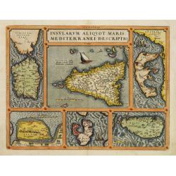
Insularum Aliquot Maris Mediterranei Descriptio.
Six maps on one sheet. In the center a map of Sicily, surrounded by maps of Sardinia, Djerba, The island of Elbe, Corfu and Malta.
Place & Date: Antwerp 1598
Selling price: $650
Sold
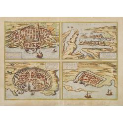
MALTA, CALARIS, RHODES, FAMAGUSTA.
Four separate views of historical Mediterranean islands on one sheet. MALTA, CALARIS, RHODES ( Rhodus ), FAMAGUSTA.From the greatest publication in this genre!. The Civit...
Place & Date: Cologne, 1598
Selling price: $1150
Sold in 2008
Insularum Aliquot Maris Mediterranei Descriptio.
Six maps on one sheet. In the center a map of Sicily, surrounded by maps of Sardinia, Djerba, The island of Elbe, Corfu and Malta.
Place & Date: Antwerp, 1598
Selling price: $700
Sold in 2018
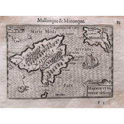
Majorcae et Minorcae descrip.
Superb miniature map of the Balearics. Including a sailing ship, sea monsters, and the title cartouche. With French text on verso.Published in his "Caert-Thresoor&qu...
Place & Date: Amsterdam, c. 1600
Selling price: $210
Sold in 2017
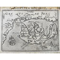
Corcyra vel Corfu
Unusual edition of this early miniature map of Corfu. With a sailing ship and a sea-monster. Latin title above the map.
Place & Date: Antwerp, ca. 1600