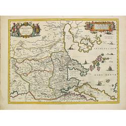
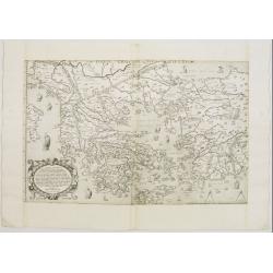
Thessaliae accurata descriptio.
A map of northeast of Greece in classical times by the hand of Johannes Laurenberg appeared in part V of Johannes Janssonius? ?Atlantis Majoris?.Embellished with two deco...
Place & Date: Amsterdam, 1650-57.
Selling price: $260
Sold
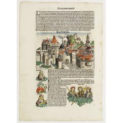
![Athene vel Minerva [Athens] Folio XXVII.](/uploads/cache/12285-250x250.jpg)
Athene vel Minerva [Athens] Folio XXVII.
A imaginary view of Athens: however the earliest obtainable view of this period.Page from the richest illustrated Incunable, the famous: Nuremberg Chronicle, published th...
Place & Date: Nuremberg, 12 July 1493
Selling price: $200
Sold in 2020
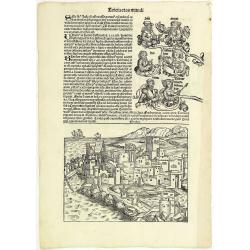
![Rhodis [Rhodes] Folio XXVI](/uploads/cache/12293-250x250.jpg)
Rhodis [Rhodes] Folio XXVI
A imaginary view of Rhodes: however the earliest obtainable view of this period.Page from the richest illustrated Incunable, the famous: Nuremberg Chronicle, published th...
Place & Date: Nuremberg, 12 July 1493
Selling price: $230
Sold in 2020
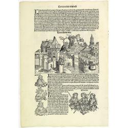
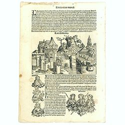
Lacedemonia.
A imaginary view of the walled Grecian city Lacedemonia: at the bottom of the leaf is an engraving of three Amazones, armed women warrior, as well as portraits of three m...
Place & Date: Nuremberg, 12 July 1493
Selling price: $250
Sold in 2017
Tercia Etas Mundi. Folium.XXVI (Rhodes)
A imaginary view of Rhodes: however the earliest obtainable view of this period.VERSO : The continuation of the biblical genealogies (as resumed from Folio XXI verso). It...
Place & Date: Nuremberg, 12 July 1493
Selling price: $120
Sold in 2013

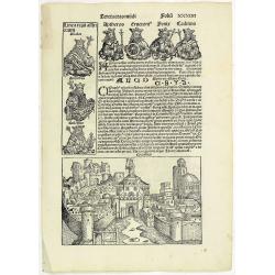
Tercia Etas Mundi. Folium. XXVII ( with a imaginary view of Athens and three kings of Egypt ).
The Latin text page is illustrated with a imaginary view of Athens: however the earliest obtainable view of this period. RECTO : three kings of Egypt—Pharaoh-mephres, P...
Place & Date: Nuremberg, 12 July 1493
Selling price: $150
Sold in 2015
Tercia Etas Mundi. Foliu. XXVIII
The Latin text page is illustrated with a depictions of Kings, Noble men and women and scientists, including Atlas. RECTO : In the first panel, at the left, are some of t...
Place & Date: Nuremberg, 12 July 1493
Selling price: $120
Sold in 2013
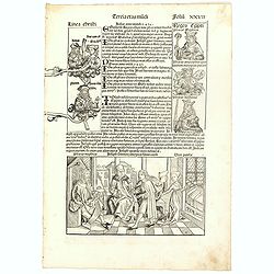
Tercia Etas Mundi. Folium.XXXIIII
The Latin text page is illustrated with an imaginary view of the city of Corinth and portraits of Aptheros (King of Crete), Erichthonius (King of Athens), Phornix and Cad...
Place & Date: Nuremberg, 12 July 1493
Selling price: $110
Sold in 2013
Tercia Etas Mundi. Foliu. XXVIII ( With view of the city of Lacedaemon - or Sparta).
The Latin text page is illustrated with a depictions of Kings, Noble men and women and scientists, including Atlas. RECTO : In the first panel, at the left, are some of t...
Place & Date: Nuremberg, 12 July 1493
Selling price: $100
Sold
Tercia Etas Mundi. Folium. XXVII (with view of Athens)
The Latin text page is illustrated with a imaginary view of Athens: however the earliest obtainable view of this period. RECTO : three kings of Egypt—Pharaoh-mephres, P...
Place & Date: Nuremberg, 12 July 1493
Selling price: $150
Sold in 2017
![Quita Etas Mundi. Foliu XXVI [ith a view of Rhodes]](/uploads/cache/46252-250x250.jpg)
Quita Etas Mundi. Foliu XXVI [ith a view of Rhodes]
The Latin text page is illustrated with a view of Rhodes in the South Aegean Sea (177 x 222mm.) The Nuremberg Chronicle, published the year that Columbus returned to Euro...
Place & Date: Nuremberg, 12 July 1493
Selling price: $150
Sold in 2020
Decima et Ultima Tabula Europae. (Greece)
Wood block printed large-format Ptolemaic map showing Greece from the 1513 edition of Waldseemüller's Geographia.One of the earliest obtainable maps of the region.This P...
Place & Date: Strasburg, 1513
Selling price: $3500
Sold in 2013
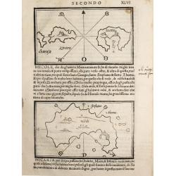
Charusa, Zinara Levita / Micole / (on verso) Stapodia and Nicaria.
Benedetto Bordone (1460-1531), cartographer and engraver. Published in 1528 his islands book, 'Isolario'.Three maps from Bernadetto Bordone?s ?Isolario?.
Place & Date: Venice, 1532
Selling price: $150
Sold
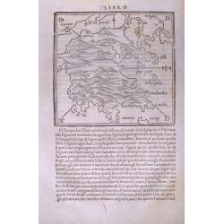
(Morea / Peloponnese peninsula)
Very early map of the Peloponnese peninsula, naming several towns and smaller islands. Published in Bordone's important "Isolario". Italian text below the map a...
Place & Date: Venice, c1534
Selling price: $110
Sold in 2014
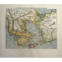
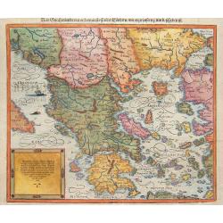
Neuw Griechenlandt, mit andern anstossenden Landern, wie es zu unsern zeiten beschriben ist.
An early woodcut map of Greece by Sebastian Münster. Showing Greece with western Turkey. The title on verso is surrounded by a beautiful woodcut border. From the German ...
Place & Date: Basel, ca 1540
Selling price: $175
Sold in 2019
![[Greece]](/uploads/cache/33846-250x250.jpg)
[Greece]
Wood block printed map and one of earliest printed representation of Greece prepared Martin Waldseemüller.Based on the slightly larger map from 1513 published in "P...
Place & Date: Vienna, Trechsel, G., 1525 -1541
Selling price: $1050
Sold in 2013
![[Map of Morea]](/uploads/cache/31508-250x250.jpg)
[Map of Morea]
Page with an early representation of the Greek Island of Morea. This text page with a fine wood block printed map is from the rare work "C. Iulii Solini Polyhistor, ...
Place & Date: Basle, Michael Isengrin, 1544
Selling price: $150
Sold in 2013
![[Map of Rhodes]](/uploads/cache/31507-250x250.jpg)
[Map of Rhodes]
Page with an early representation of the Greek Island of Rhodes. This text page with a fine wood block printed map is from the rare work "C. Iulii Solini Polyhistor,...
Place & Date: Basle, Michael Isengrin, 1544
Selling price: $60
Sold in 2018
![[Map of Greece]](/uploads/cache/31493-250x250.jpg)
[Map of Greece]
Page with an early representation of Greece. This text page with a fine wood block printed map is from the rare work "C. Iulii Solini Polyhistor, Rerum Toto Orbe Mem...
Place & Date: Basle, Michael Isengrin, 1544
Selling price: $100
Sold in 2016
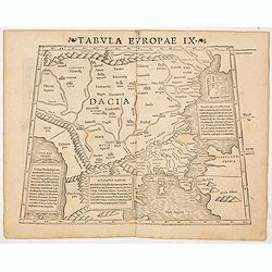
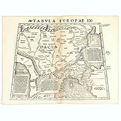
Tabula Europae IX ( Greece & Turkey)
The first edition of Munster's map of Greece & Turkey, based upon Claudius Ptolemy which appeared in his "Geographia Universalis", first published in 1540. ...
Place & Date: Basel, Heinrich Petri, 1545
Selling price: $300
Sold in 2014
Tabula Europae IX ( Greece & Turkey).
The first edition of Munster's map of Greece & Turkey, based upon Claudius Ptolemy which appeared in his "Geographia Universalis", first published in 1540. ...
Place & Date: Basel, Heinrich Petri, 1545
Selling price: $200
Sold in 2021
![Tabula Europae IX [Greece and Turkey]](/uploads/cache/98813-250x250.jpg)
Tabula Europae IX [Greece and Turkey]
First edition of Münster's map of Greece & Turkey plus the region west of the Black Sea and north of the Aegean and Adriatic Seas.Based on Claudius Ptolemy which app...
Place & Date: Basel, 1545
Selling price: $200
Sold in 2019
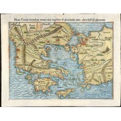
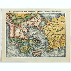
Noua Graecia secundum omnes eius regiones & prouincias citra ultra & Hellespontum
Nice colored woodcut map of Greece with the western part of Turkey. From an edition of "Cosmographiae Universalis" by Sebastian Münster.
Place & Date: Basle, 1550
Selling price: $350
Sold in 2009
New Griechenlande/mit andern anstossenden Ländern/wie es zu unsern zeiten beschriben ist . . .
Map of Greece with the Peloponnese an all islands, partly showing Crete.
Place & Date: Basel, 1550
Selling price: $300
Sold in 2014
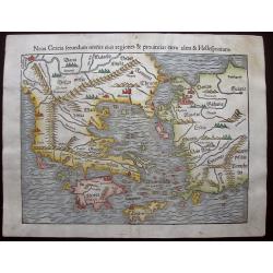
Noua Graecia, secundum omneseius regiones & prouincias citra & ultra Hellespontum.
A fine graphic example of Munster's map of Greece, Turkey, and adjoining regions, from the 1550-Latin edition of Munster's Cosmographia. It extends to Just north of the D...
Place & Date: Basle, 1550
Selling price: $230
Sold in 2015
![[Lot of 34 leaves relating to Greece and Turkey]](/uploads/cache/48274-250x250.jpg)
[Lot of 34 leaves relating to Greece and Turkey]
Thirty-four text pages with wood block illustrations about Greece and Turkey with small maps, views, animals.... From the 1552 Latin text edition of Münster's Cosmograph...
Place & Date: Basel, 1552
Selling price: $51
Sold in 2022
Nova Graecia secundum omnes eius regiones & provincias citra ultra & Hellespontum.
Early map of Greece, Turkey and adjoining regions from the 1552 Latin text edition of Münster's Cosmographia, which is a short and complete summary of Renaissance knowl...
Place & Date: Basel, 1552
Selling price: $300
Sold in 2023
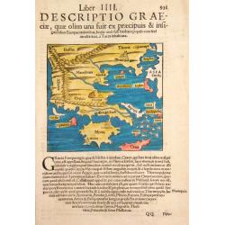
Descriptio Graeciae.
Sebastian Münster, 1489-1552, outstanding geographer of Basle. Editied Ptolemy's atlas ' Geographia Universalis', editions 1540,-42, -45, -51 and -52. Published his &quo...
Place & Date: Basle, 1554
Selling price: $100
Sold
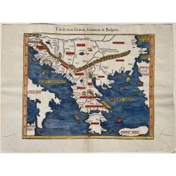
Tabula nova Graeciae, Sclavoniae, & Bulgariae
Woodcut map of the Greek mainland and islands, including Crete. Also shown are parts of Italy, Croatia, Albania, Serbia, Northern Macedonia, Bulgaria and Turkey. After Pr...
Place & Date: Basel, ca. 1555
Selling price: $240
Sold in 2023
Tabula Europa X . . .
Uncommon first edition of this map of Ancient Greece.Girolamo Ruscelli's edition of Ptolemy's Geographia included newly engraved copperplates by Giulio and Livio Sanuti. ...
Place & Date: Venice, 1561
Selling price: $110
Sold in 2012
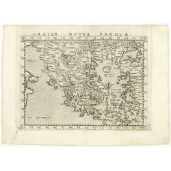
Graetia Nuova Tavola.
Uncommon first edition of this early map of Greece.Girolamo Ruscelli's edition of Ptolemy's Geographia included newly engraved copperplates by Giulio and Livio Sanuti. Th...
Place & Date: Venice, 1561
Selling price: $250
Sold in 2011
![[Crete] EL VERO ET NVOVO DISEGNO, DI TVTTA LA ISOLA, DI CANDIA.](/uploads/cache/23788-250x250.jpg)
[Crete] EL VERO ET NVOVO DISEGNO, DI TVTTA LA ISOLA, DI CANDIA.
Fine map of Crete. No further states are recorded.Engraved by Paolo Forlani (active 1561-1577). Title in banner in top. In lower right corner a cartouche including the hu...
Place & Date: Venice 1564
Selling price: $2500
Sold in 2010
Vogliono alcuni l'isola di Corfu fosse prima ..
Fine map of the island of Kerkyra (Corfu), based on a map of the French artist Jacques Prevost. The present edition by Fernando Bertelli (ascribed by D.Woodward to Paolo ...
Place & Date: Venice, 1564
Selling price: $2100
Sold in 2010
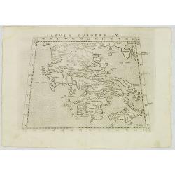
Totius Graeciae Descriptio.
A rare map of Greece. One of the first printed maps of Greece, decorated with many ships. A unique opportunity to acquire a fine example of a map from the early Lafreri s...
Place & Date: Venice, 1564
Selling price: $14250
Sold in 2010
![[Versalis Lib I]](/uploads/cache/38533-250x250.jpg)
[Versalis Lib I]
One text page with Latin text with reference to Delos, Rhodes, Alone, Thera/ Sicilia and Therasia, illustrated with a fancy wood cut map (130 x 145 mm) with three dimensi...
Place & Date: Basle, ca. 1564
Selling price: $25
Sold in 2018
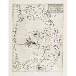
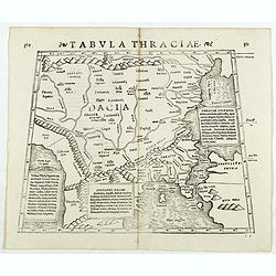
Tabula Thraciae.
Tabula Thraciae by Sebastian Münster, woodblock engraved Strabonis Ptolemeic map. Map of Greece and North Europe first published in Münster's edition of Ptolemy's 'Geog...
Place & Date: Basle, by Heinrich Petri, 1571
Selling price: $230
Sold in 2016
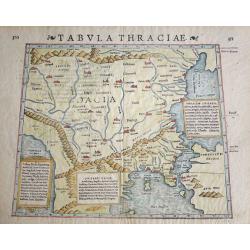
Tabula Thraciae. (Bulgaria, northern Greece, and the European part of Turkey)
Double-page woodcut Ptolemaic-style map by Sebastian Münster figuring Thrace, roughly corresponding to modern day Bulgaria, northern Greece, and the European part of Tur...
Place & Date: Basle, Henri Petri, 1571
Selling price: $150
Sold in 2018
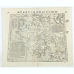
Tabula Graeciae. (Greece and Greek islands)
Double-page woodcut Ptolemaic-style map by Sebastian Münster figuring Greece, published in the edition of Strabo by Henri Petri in 1571."Strabonis rerum geographica...
Place & Date: Basle, Henri Petri, 1571
Selling price: $85
Sold in 2018
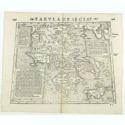
Tabula Graeciae. (Greece)
Double-page woodcut Ptolemaic-style map by Sebastian Münster figuring Greece and Greek islands, published in the edition of Strabo by Henri Petri in 1571."Strabonis...
Place & Date: Basle, Henri Petri, 1571
Selling price: $50
Sold in 2018
![[Rhodus].](/uploads/cache/41985-250x250.jpg)
[Rhodus].
Woodcut Ptolemaic-style map by Sebastian Münster figuring Rhodes Island, published in the edition of Strabo by Henri Petri in 1571."Strabonis rerum geographicarum&q...
Place & Date: Basle, Henri Petri, 1571
Selling price: $50
Sold in 2018