Browse Listings in Europe > Eastern Europe
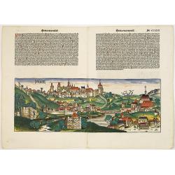
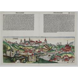
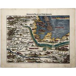
Praga. [Prague CCXXX
A very fine view of Prague. Verso showing different scenes from the town's history. Among an early depiction of a comet recorded in December 1351.Page from the richest il...
Place & Date: Nuremberg, 12 July 1493
Selling price: $1850
Sold in 2010
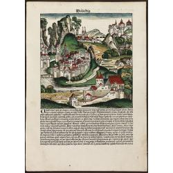
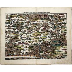
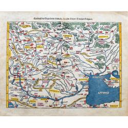
Walachia
Decorative colored incunable leaf in folio showing an imaginary view of Walachia (Romania) by Hartmann Schedel. From the famous Liber chronicarum or Nuremberg Chronicle i...
Place & Date: Nuremberg, 1493
Selling price: $250
Sold in 2013
![[Hungaria]](/uploads/cache/92308-250x250.jpg)
[Hungaria]
Decorative colored incunable leaf in folio showing an imaginary landscape in Hungary by Hartmann Schedel. From the famous Liber chronicarum or Nuremberg Chronicle in Lati...
Place & Date: Nuremberg, 1493
Selling price: $230
Sold in 2013
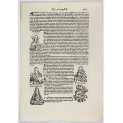
Sexta Etas Mundi. Folium. CCXI. (wit portrait of Elizabeth of Hungary).
Latin text page with woodcuts on recto and verso of Saints, Kings, and Queens. In upper left corner a portrait of Elizabeth of Hungary, portrayed in the act of giving foo...
Place & Date: Nuremberg, 12 July 1493
Selling price: $100
Sold in 2018
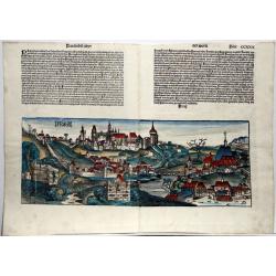
Praga. (Prague/Praha).
An incunable engraving. A very fine view of Prague. Verso showing different scenes from the town's history. Among an early depiction of a comet recorded in December 1351....
Place & Date: Nuremberg, 1493
Selling price: $1000
Sold in 2020
Praga
First printed view of Prague, Czech Republic, by Hartmann Schedel from the Latin edition of the “Liber chronicarum” published in 1493. The woodcut is quiet realistic ...
Place & Date: Nurenberg, 1493
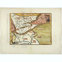
(Untitled map) Prussie et Lituanie Pars, Polonia, Russia, Transilvania, . . .
Early woodcut map of the area of Eastern Europe from Lithuania and Prussia in the north to Hungary and Valachia in the south. It also includes Transylvania, Russia. Polan...
Place & Date: Strasbourg, 1522
Selling price: $750
Sold in 2018
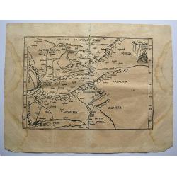
Tabu Moderna Hungariae, Poloniae, Russiae, Prussiae, et Valachiae.
A wood cut engraved map of modern day Hungary, Poland, Russia, Prussia and Romania on Ptolemaic projection from "Geographia", with maps by Laurens Fries and the...
Place & Date: Strassburg, 1522 -1525
Selling price: $500
Sold in 2019
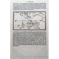
(Istria, Lošinj, Krk, Cres, Rab; Vis)
One of the earliest maps showing Croatian (Dalmatian) islands in the Adriatic Sea. Wood cut with italian text on both sides, and with a map on each side. One map, with a ...
Place & Date: Venice, c1534
Selling price: $50
Sold in 2015
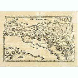
EUROPAE Tabula Quinta continet Rhetiam et Vindeliciam?
A Ptolemaic map of the Dalmatian coast but also showing parts of Italy, and the northern tip of Corsica. ¤
Place & Date: Vienne, 1541
Selling price: $400
Sold in 2009
![Europae Tabula quarta continet. [Central Europe]](/uploads/cache/15350-250x250.jpg)
Europae Tabula quarta continet. [Central Europe]
The earliest printed representation of Germany, Poland and central Europe.
Place & Date: Vienne 1541
Selling price: $400
Sold in 2008
Europae Tabula Decima continent (Title on verso)
Attractive woodblock Ptolemaic map showing south east Europe from the Adria to the black sea with Albania, Mazedonia, North-Greece to the Bosporus. Some detail of Turkey ...
Place & Date: Strasbourg 1541
Selling price: $350
Sold in 2019
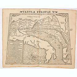
Tabula Europae V ( Adriatic Sea and the Balkans)
The first edition of Munster's Ptolemaic map of the Adriatic Sea and the Balkans appeared in his "Geographia Universalis", first published in 1540. This was a n...
Place & Date: Basel, Heinrich Petri, 1545
Selling price: $275
Sold in 2014
Bohemia Praha Budweiss Cheb.
Fine wood block engraved map of Bohemia or The Czech Republic by Sebastian Münster. Published in "COSMOGRAPHIA". The page includes copper engravings of a royal...
Place & Date: Basel, ca. 1550
Selling price: $26
Sold in 2016
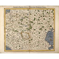
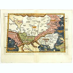
Landtafel des Ungerlands / Polands / Reussen / Littaw / Walachey und Bulgarey
Early, attractive colored woodcut map showing the area between Poland, Austria and Croatia in the West and from Moscow to Istanbul (Constantinople)in the East. From a Ger...
Place & Date: Basle, 1550
Selling price: $300
Sold in 2008
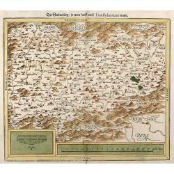
Die Siebenburg, so man sunst auch Transsylvaniam nennt
Early, attractive colored woodcut map showing Transylvania today part of Romania. From a German edition of Cosmographia from Sebastian Munster.
Place & Date: Basle, 1550
Selling price: $200
Sold in 2008
![Tabula Asiae VII. [Central Asia and Russia]](/uploads/cache/29552-250x250.jpg)
Tabula Asiae VII. [Central Asia and Russia]
Wood block printed map with letter press on verso. A Ptolemaic map of the region north and east of the Black Sea and Caspian Sea, extending to the Imaus Mountains.Münste...
Place & Date: Basle, c.1550
Selling price: $200
Sold in 2010
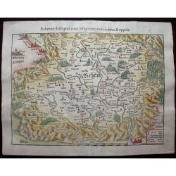
Bohemiae descriptio iuxta insigniores eius civitates & oppida
This particular woodblock map displays the Czech Republic centred on Prague and the Elb River. Cities, towns, rivers and mountains are shown along with a key at lower rig...
Place & Date: Basle, 1550
Selling price: $120
Sold in 2014
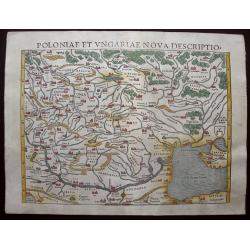
Poloniae Et Ungariae XV Nova Descriptio.
Early edition Munster's map of Poland, Lithuania, the Ukraine, Moscovy and the Balkans, extending from Prussia, Vilna and Smolensky in the north to Bosnia, Bulgaria, Cons...
Place & Date: Basle, 1550
Selling price: $180
Sold in 2014
SCLAVONIA ODER WINDISCH MARCK, BOSSEN, CRABATEN (Croatia, Dalmatia)
A beautifully colored, antique woodcut map of Dalmatia, Bosnia, Slovenia, Croatia.
Place & Date: Basle, 1550
Selling price: $130
Sold in 2021
Transilvania.
A beautifully colored map of the "Seven Cities" also known as 'Transsylvania', today western Romania.
Place & Date: Basle, 1550
Selling price: $150
Sold in 2021
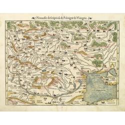
Nouvelle description de Poloigne & Hongrie.
Munster's map of Poland, Lithuania, the Ukraine, Muscovy and the Balkans, extending from Prussia, Vilna and Smolensk in the north to Bosnia, Bulgaria, Constantinople and ...
Place & Date: Basle, 1552
Selling price: $700
Sold in 2010
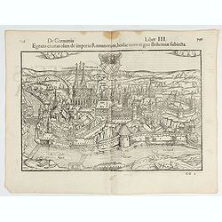
Egrana civitas olim imperio Romanorum…
Early woodcut view of the city of Egra (Cheb) in the Czech Republic. From the 1552 Latin text edition of Münster's Cosmographia, which is a short and complete summary of...
Place & Date: Basel, 1552
Selling price: $30
Sold in 2022
![[Lot of 31 leaves] Solothurensis civitatis effigies…](/uploads/cache/48272-250x250.jpg)
[Lot of 31 leaves] Solothurensis civitatis effigies…
Thirty-one text pages with several wood block prints with maps and views relating to Hungary, Serbia, Bulgaria, Poland and Russia. Taken from the 1552 Latin text edition ...
Place & Date: Basel, 1552
Selling price: $55
Sold in 2022
![[Lot of 10 leaves of Bohemia, Moravia]](/uploads/cache/48296-250x250.jpg)
[Lot of 10 leaves of Bohemia, Moravia]
Ten text leaves illustrated with wood block prints relating to Bohemia and Moravia. From the 1552 Latin text edition of Münster's Cosmographia, which is a short and com...
Place & Date: Basel, 1552
Selling price: $26
Sold in 2022
Landtafel des Ungerlands / Polands / Reussen / Littaw / Walachei / Bulgarei.
Early woodcut map from Münster's Cosmographia, one of the most influential geographical works of the 16th Century. It shows the area from Prussia to Constantinople and...
Place & Date: Basle, ca. 1560
Selling price: $250
Sold in 2023
![Bohemici Regni . . . [Czechoslovakia]](/uploads/cache/38517-250x250.jpg)
Bohemici Regni . . . [Czechoslovakia]
One Latin text page with a wood cut engraved map of Czechoslovakia centered on Prague (93 x 135 mm). From Münster's Cosmographia Universalis.The Cosmographia by Sebastia...
Place & Date: Basle, ca. 1564
Selling price: $15
Sold in 2016
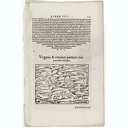
Ungariae & Omnium partium eius. (Hungary)
One Latin text page with a wood cut engraved map of Hungary (100 x 135 mm). From Münster's Cosmographia Universalis. The Cosmographia by Sebastian Münster from 1544 is ...
Place & Date: Basle, ca. 1564
Selling price: $10
Sold in 2016
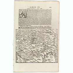
Transsylvania Ungarici Regni Provincia.
One text page with a map of Hungary, Moravia and Macedonia (150 x 190 mm). On verso Latin text page with a small wood cut of a monastery on a mountain.From Münster's Cos...
Place & Date: Basle, ca. 1564
Selling price: $25
Sold in 2016
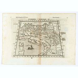
Tabula Europae V.
Early map of the Balkans. Girolamo Ruscelli first published the map in his "La Geographi di Claudio Tolomeo" (Venice, 1561). In 1574 a new plate was used which ...
Place & Date: Venice, 1564
Selling price: $60
Sold in 2020
![[Gÿor] Iavarino in Ongaria et trinciere dove al presente al ritrova lo Imperatore aloggiato con lo essercito . . .](/uploads/cache/25020-250x250.jpg)
[Gÿor] Iavarino in Ongaria et trinciere dove al presente al ritrova lo Imperatore aloggiato con lo essercito . . .
Showing the siege of Iavarin (nowadays Gÿor). Title in a cartouche lower left, with compass rose, date 1566 and initials of Marios Kartaro. A unique opportunity to acqui...
Place & Date: Venice, 1566
Selling price: $1000
Sold in 2010
![[Gÿor] Iavarino in Ongaria et trinciere dove al presente al ritrova lo Imperatore aloggiato con lo essercito ...](/uploads/cache/32490-250x250.jpg)
[Gÿor] Iavarino in Ongaria et trinciere dove al presente al ritrova lo Imperatore aloggiato con lo essercito ...
Showing the siege of Iavarin (nowadays Gÿor). Title in a cartouche lower left, with compass rose, date 1566 and initials of Marios Kartaro.A unique opportunity to acquir...
Place & Date: Venice, 1566
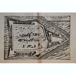
![[Tokaj] Tochai, fortezza nei confini di Transilvania et Ongharia, assediato dal campo del Re Ioannes Secondo ..](/uploads/cache/16892-250x250.jpg)
[Tokaj] Tochai, fortezza nei confini di Transilvania et Ongharia, assediato dal campo del Re Ioannes Secondo ..
Extremely rare bird's-eye plan of the siege of the town and fortress Tokaj in Hungary in 1566.The print is signed Dnco Zenoi.Engraved by Domenico Zenoi, who was an engra...
Place & Date: Venice 1568
Selling price: $400
Sold
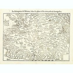
La description de Boheme selon les plus nobles cites...
Early map of Czechoslovakia, oriented south to the top. From a French edition of Münster's Cosmographia Universalis.
Place & Date: Basel, 1552 - 1568
Selling price: $95
Sold in 2019
Vera et ultima discrittione di tutta l'Austria, Vnghe= ria, Transiluania, Dalmatia, et altri paesi come nel dise= / gno apare, graduata, con la scala di miglia jtaliani.
With the Gulf of Venice in the lower left corner and Belgrade in the lower right corner with camels. Engraved by Paolo Forlani (active 1561-1577). The border between Hung...
Place & Date: Venice 1568
Selling price: $2000
Sold
![Agria. [Eger]](/uploads/cache/32539-250x250.jpg)
Agria. [Eger]
Rare Lafreri School town-plan of Eger in Hungary, engraved by Paolo Forlani, of the Lafreri school of mapmakers, first published in "Il Primo Libro Delle Citta, Et F...
Place & Date: Venice, Zaltieri, (1567) 1568
Selling price: $54
Sold in 2014
Comar.
Rare Lafreri School view of the fortification of Comar, engraved by Paolo Forlani of the Lafreri school of mapmakers, dated 1567, first published in "Il Primo Libro ...
Place & Date: Venice, Zaltieri, (1567) 1568
Selling price: $60
Sold in 2018
![GIAVARINO [ Gyor HUNGARY]](/uploads/cache/38741-250x250.jpg)
GIAVARINO [ Gyor HUNGARY]
Rare Lafreri School 1566 battle plan of Gyor, engraved by Paolo Forlani, of the Lafreri school of mapmakers, first published in "Il Primo Libro Delle Citta, Et Forte...
Place & Date: Venice, Zaltieri, 1568
Selling price: $280
Sold in 2017
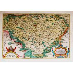
Regni Bohemiae Descriptio.
Abraham Ortelius(1527-98), Dutch cartographer and publisher of the first modern atlas, ' Theatrum Orbis Terrarum' in 1570. Editions till 1612. Also an atlas of ancient ca...
Place & Date: Antwerp, 1571
Selling price: $400
Sold
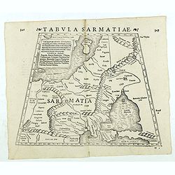
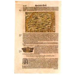
Tabula Sarmatiae. (Eastern Europe including Poland and Black sea region)
Double-page woodcut Ptolemaic-style map by Sebastian Münster figuring Eastern Europe including Poland, Lihuania and Black sea region, published in the edition of Strabo ...
Place & Date: Basle, Henri Petri, 1571
Selling price: $90
Sold in 2018