Browse Listings
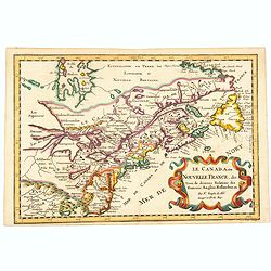
Le Canada, ou Nouvelle France, &c, tiree de diverses Relations des Francois, Anglois, Hollandois, &c. . .
A fine smaller map of the north eastern US seaboard, extending to the Great Lakes (shown as open-ended) and beyond into 'Upper Canada' by Nicolas Sanson, and originally f...
Place & Date: Utrecht, 162
Selling price: $420
Sold in 2021
![Die ander Tafel des Rheinstromes, begreiffendt die Pfaltz, Westereich, Eyfel,sc. [Course of the Rhine from approx. Strassbourg to Andernach]](/uploads/cache/84787-250x250.jpg)
Die ander Tafel des Rheinstromes, begreiffendt die Pfaltz, Westereich, Eyfel,sc. [Course of the Rhine from approx. Strassbourg to Andernach]
Wood block map of a part of the course of the Rhine and surrounding lands, by Sebastian Munster.One of the Earliest Modern Maps of the Rhine river. This map is the second...
Place & Date: Basel 1550 ca.
Selling price: $130
Sold in 2020
![[Holy Land, Cyprus]](/uploads/cache/84451-250x250.jpg)
[Holy Land, Cyprus]
Attractive colored woodcut map showing the Holy Land with Cyprus. With a ship and a sea monster. From a Latin edition of Cosmographia by Sebastian Munster.
Place & Date: Petri, Basle, 1550 ca.
Selling price: $175
Sold in 2020
![Marocco [Morocco]](/uploads/cache/1152967-250x250.jpg)
Marocco [Morocco]
Original hand-colored double page map (39 x 53 cm, overall dimensions 50 x 64 cm.).
Place & Date: London: James Wyld. Geographer to the Queen, 457 West Strand, 11 & 12
Selling price: $180
Sold in 2020
Nova Europae Descriptio.
A fine uncolored version of Hondius' second map of Europe, first issued in 1606. From: Jodocus Hondius, 'Atlas sive cosmographicæ meditationes de fabrica mundi et fabric...
Place & Date: Amsterdam, 1621-/23
Selling price: $615
Sold in 2020
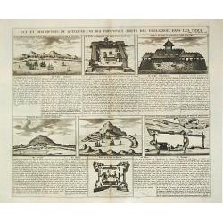
Vue et description de quelques-uns des principaux forts des Hollandois dans les Indes.
Henri Abraham Chatelain was a Amsterdam-based geographer and publisher. His main product is the Atlas Historique et Méthodique, in seven volumes, published between 1710 ...
Place & Date: Amsterdam, 1710-20.
Selling price: $150
Sold
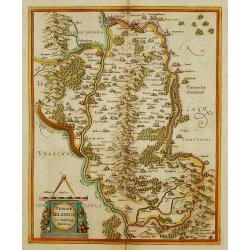
Udrone Irlandiae in Catherlagh Baronia.
Depicts present day County Carlow in Leinster Province & Catherlaugh which is now Carlow. The title is surrounded by a strap work design cartouche topped with caliper...
Place & Date: Amsterdam 1639-44.
Selling price: $160
Sold
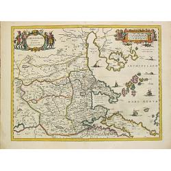
Thessaliae accurata descriptio.
A map of northeast of Greece in classical times by the hand of Johannes Laurenberg appeared in part V of Johannes Janssonius? ?Atlantis Majoris?.Embellished with two deco...
Place & Date: Amsterdam, 1650-57.
Selling price: $260
Sold
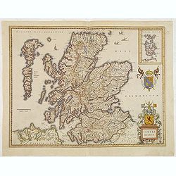
Scotia Regnum.
A attractive example of this fine map of Scotland.
Place & Date: Amsterdam, ca.165
Selling price: $260
Sold in 2013
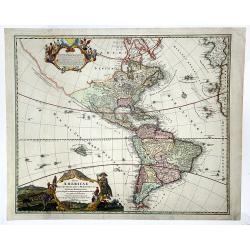
Totius AMERICAE Septentrionalis et Meridionalis novissima represestatio quam ex fingulis. . .
A richly ornamented map of North and South America. Title cartouche bottom left is copied from De Fer's map of 1699 and the cartouche containing text (top left) is based ...
Place & Date: Nuremberg, 1740 ca
Selling price: $600
Sold in 2020