Browse Listings in Asia > Tartary / Siberia
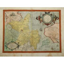
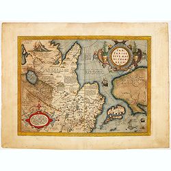
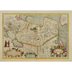
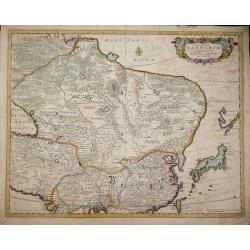
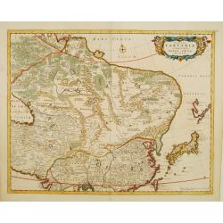
Tartariae sive Magni Chami Regni.
Beautiful old color example of Ortelius' map of Tartary, Japan and the West Coast of North America, from the early 1573 Latin edition Ortelius' Theatrum Orbis Terarrum, t...
Place & Date: Antwerp, 1573
Selling price: $1550
Sold in 2014
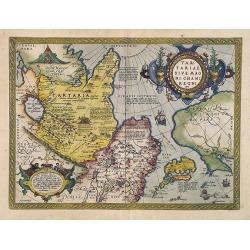
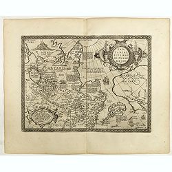
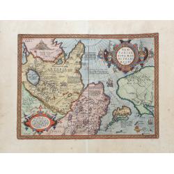
Tartariae sive Magni Chami Imperium.
This is a very early depiction of the northern Pacific, with the first mapping of Northwest Coast of America and probably the first map to name California 'C. Califormio'...
Place & Date: Antwerp, 1580
Selling price: $1600
Sold in 2009
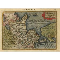
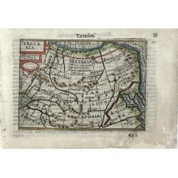
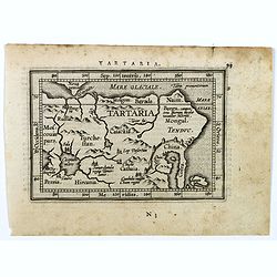
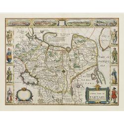
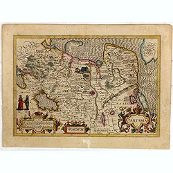
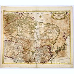
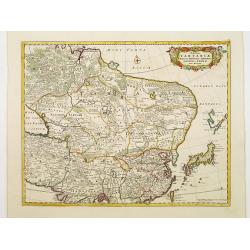
Tartaria sive magni chami regni typus.
This small map is the reduced version of the earliest map to focus on the North Pacific. While designed to illustrate the expansive Kingdom of the Great Khan in Asia, its...
Place & Date: Antwerp, 1588
Selling price: $140
Sold
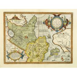
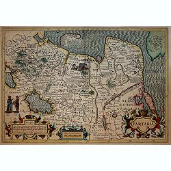
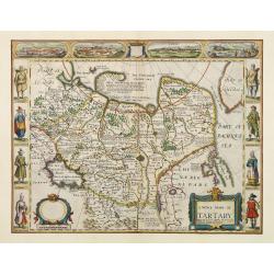
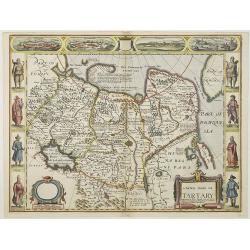
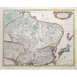
Tartariae sive magni Chami regni typus.
The map identifies China and Japan, but not Korea. The body of water lying between China and Japanese archipelago is identified as MARE CIN, which means China Sea.Much of...
Place & Date: Antwerp, 1590
Selling price: $2000
Sold in 2012
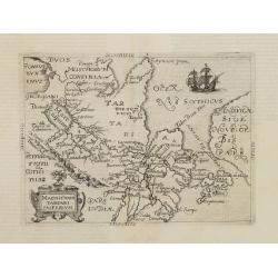
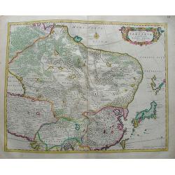
Tartariae sive Magni Chami Imperium.
This is a very early depiction of the northern Pacific, with the first mapping of Northwest Coast of America and probably the first map to name California 'C. Califormio'...
Place & Date: Antwerp, c. 1590
Selling price: $1050
Sold in 2014
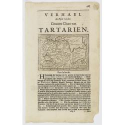
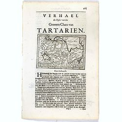
Tartaria
Very fine early miniature map of Tartaria with the wall on the map, this map is from the first edition of the Langenes atlas, (later well known under the name of Bertius)...
Place & Date: Middelburg, 1598
Selling price: $140
Sold in 2010
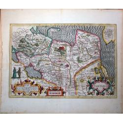
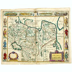
Tartariae sive magni Chami regni typus.
Much of the information shown on this map relates to the travels of Marco Polo between 1275 and 1291 with later information gained from the Portuguese Jesuit missionaries...
Place & Date: Antwerp, 1598
Selling price: $950
Sold in 2018
Magni Chami Tartari Imperium.
Included in German edition of José de Acosta's De Natura Nova Orbis . Acosta was a Spanish Jesuit missionary, historian and cosmographer.Scarce. Including the north west...
Place & Date: Cologne 1600
Selling price: $1450
Sold
Tartaria.
This splendid map covers all of northern Asia from Moscow to the Anian Fretum and Americae Pars. Korea is shown as an island. Illustrations include the Great Wall in Chin...
Place & Date: Amsterdam, 1606
Selling price: $1000
Sold in 2011
Tartaria.
Published in Hondius' editions of the Mercator Atlas from 1606 onwards, showing China, Korea and the northern Pacific coast of America showing the two continents separate...
Place & Date: Amsterdam, 1606
Selling price: $560
Sold in 2017
Tartariae sive magni regni...
An attractive old color example of this important map of Tartary, Japan, and the west coast of North America, from Ortelius' Theatrum Orbis Terarrum, the first modern at...
Place & Date: Amsterdam, 1608
Tartaria.
A delightful, well engraved miniature map of Tartary (northeastern Asia) with Japan, Korea, and a lovely rustic depiction of the Great Wall of China. Latin text on verso....
Place & Date: Antwerp, ca. 1609
Selling price: $100
Sold in 2016

Tartariae sive Magni Chami Imperium.
This is a very early depiction of the northern Pacific, with the first mapping of Northwest Coast of America and probably the first map to name California 'C. Califormio...
- $2500 / ≈ €2339
Place & Date: Antwerp, c. 1608-1612
![Tamerlanes. Magnus. Imperator Tartarorum. 1398. [Tamerlane]](/uploads/cache/24304-250x250.jpg)
Tamerlanes. Magnus. Imperator Tartarorum. 1398. [Tamerlane]
The engraving depicts a Europeanized half length oval portrait of Tamerlane (1336 - 1405) - The Last Great Nomad Power.Nicolaes de Clerck (de Klerc) was active as engrave...
Place & Date: Amsterdam, Cloppenburch, 1621
Selling price: $35
Sold
Tartaria.
Small map of Tartary, including the Great Wall and part of China. Surrounded by text in Dutch. Showing part of the Great Wall of China in the lower right corner.Nicolaes ...
Place & Date: Amsterdam, Cloppenburch, 1621
Selling price: $135
Sold
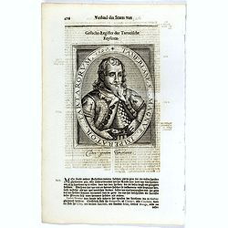
Tamerlanes. Magnus. Imperator Tartarorum. 1398.
The engraving depicts a half length oval portrait of "Tamerlanes. Magnus. Imperator Tartarorum.".Nicolaes de Clerck (de Klerc) was active as engraver and publis...
Place & Date: Amsterdam, Cloppenburch, 1621
Selling price: $20
Sold in 2016
Tartaria.
Small map of Tartary, including the Great Wall and part of China. Surrounded by text in Dutch. Showing part of the Great Wall of China in the lower right corner.Nicolaes ...
Place & Date: Amsterdam, Cloppenburch, 1621
Selling price: $135
Sold in 2016
Tartaria.
The rare Samuel Purchas\' edition of the Mercator/Hondius Atlas Minor atlas map. Early map showing China, Korea and the northern Pacific coast of America showing the two ...
Place & Date: London, 1625
Selling price: $200
Sold in 2009
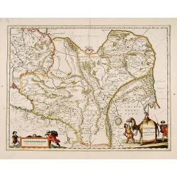
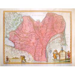
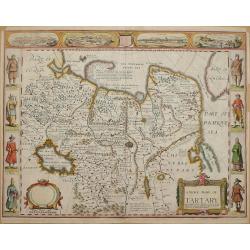
A newe map of Tartary.
One of the most decorative maps of Tartary, known for its figured borders with people in local dress, among them a woman and man in local dress. Upper panel of town panor...
Place & Date: London 1626
Selling price: $1100
Sold
A newe map of Tartary.
One of the most decorative maps of Tartary, known for its figured borders with people in local dress, among them a woman and man in local dress. Upper panel of town panor...
Place & Date: London 1626
Selling price: $1400
Sold
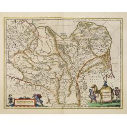
A newe mape of Tartary.
Early edition of one of the most decorative maps of Tartary, known for its figured borders with costume figures, while above are vignettes of the cities of Astrakhan, Sam...
- $2500 / ≈ €2339
Place & Date: London, 1627
Tartaria.
Published in Hondius' editions of the Mercator Atlas from 1606 onwards, showing China, Korea and the northern Pacific coast of America showing the two continents separate...
Place & Date: Amsterdam, 1630
Selling price: $165
Sold in 2018
Tartaria.
Published in Hondius' editions of the Mercator Atlas from 1606 onwards, showing China, Korea and the northern Pacific coast of America showing the two continents separate...
Place & Date: Amsterdam 1633
Selling price: $450
Sold
Tartaria.
Published in Hondius' editions of the Mercator Atlas from 1606 onwards, showing China, Korea as an island, and the northern Pacific coast of America showing the two conti...
Place & Date: Amsterdam, 1633
Selling price: $575
Sold in 2015
Tartariae sive Magni Chami Imperium.
Fine map of Tartary, including northern part of China, and tip of Korea.
Place & Date: Amsterdam 1638
Selling price: $365
Sold
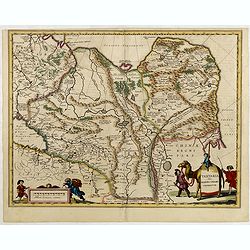
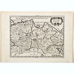
Tartaria sive Magni Chami imperium.
Detailed and decorative map of Tartary [i.e. Mongolia and Siberia] which is annotated with the major cities and towns of the region. Chinae Regni Pars [i.e. China] is sho...
Place & Date: Amsterdam, 1645
Selling price: $600
Sold in 2010
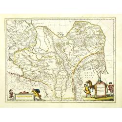
Tartaria sive Magni Chami Imperium.
Detailed and decorative map of Tartary and Northern part of China. Northern tip of Korea included. The Chinese Great Wall is depicted, with Central Asia, extending from M...
Place & Date: Amsterdam, 1645
Selling price: $480
Sold in 2010
Tartariae sive Magni Chami Imperium.
Fine map of Tartary, including northern part of China, and tip of Korea.
Place & Date: Amsterdam, 1645
Selling price: $150
Sold in 2015
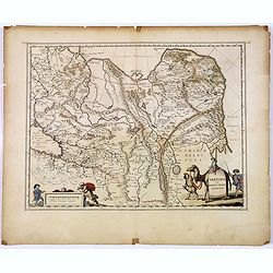
Tartaria sive Magni Chami Imperium.
A detailed and decorative map of Tartary and the northern part of China. The very northern tip of Korea included. The Chinese Great Wall is depicted, with Central Asia, e...
Place & Date: Amsterdam, 1645
Selling price: $70
Sold in 2018
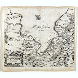
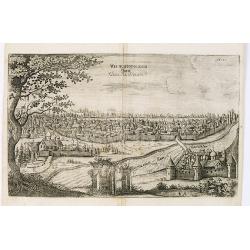
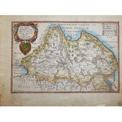
Vera Delineatio Prouinciae Fertilissimae . . .
Detailed map of the Southern Caspian Sea, showing the area north of Tehran. From the rare first edition "Offt begehrte Beschreibung der newen orientalischen Rejse, s...
Place & Date: Schleßwig, Zur Glocken, 1647
Selling price: $400
Sold in 2021
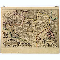
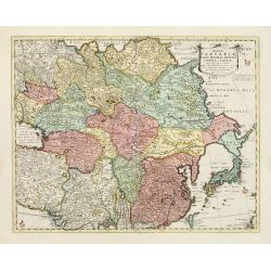
Tartaria Sive Magnichami Imperium.
Decorative copperplate map of china, tartary and Central Asia from Mongolia and Xanadu to the Caspian Sea and Volva River and to Tibet nad the Ganges River. Two splendid ...
Place & Date: Amsterdam, 1650
Selling price: $220
Sold in 2016
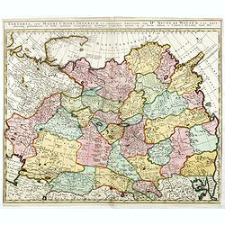
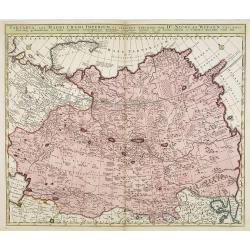
Tartaria sive Magni Chami Imperium
A pleasing example of Blaeu's map of Tartary (Siberia) and Central Asia, extending from Mongolia and Xanadu to the Caspian and the Volga River, and to Tibet and the Upper...
Place & Date: Amsterdam, c1650
Selling price: $220
Sold in 2016
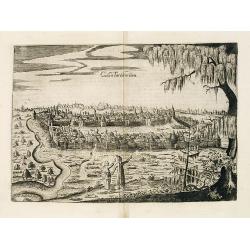
Casan Tartacorium.
An early of Kazan, with the Volga river on the left. From "Voyages en Moscovie, Tartarie et Perse, par Adam Olearius".Adam Olearius was a seventeenth-century G...
Place & Date: Paris, Abraham de Wicquefort , 1656
Selling price: $500
Sold in 2010
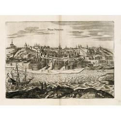
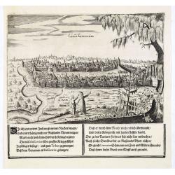
View of Nisen-Navgorod.
An early of Nisen-Navgorod, on the Volga river. From "Voyages en Moscovie, Tartarie et Perse, par Adam Olearius".Adam Olearius was a seventeenth-century German...
Place & Date: Paris, Abraham de Wicquefort , 1656
Selling price: $850
Sold in 2013
View of Weliki Nowgorod.
An early of Weliki Nowgorod, in the North-West of Russia, on the Volkhov river.From "Voyages en Moscovie, Tartarie et Perse, par Adam Olearius".Adam Olearius w...
Place & Date: Paris, Abraham de Wicquefort , 1656
Selling price: $750
Sold in 2012
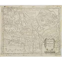
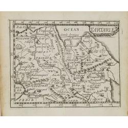
Scythia et Tartaria Asiatica.
Interesting map of Tartary and Scythia from a German edition of Philipp Clüver's famous Introductionis in Universam geographicam, first published in Leiden in 1624. Phil...
Place & Date: Wolfenbüttel, 1661
Selling price: $30
Sold in 2009
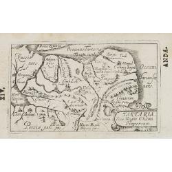
Tartaria Sive Magni Chami Imperium.
Charming little map of Tartary made by Gabriel Bucelin (1599-1681). Bucelin was a Swiss genealogist and an author of several books and a number of manuscript maps of Germ...
Place & Date: Ulm, Johannes Görlin, 1658-1664
Selling price: $85
Sold in 2008
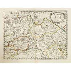
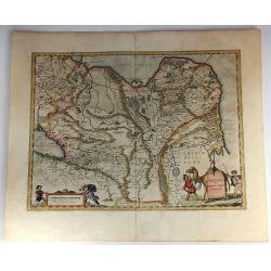
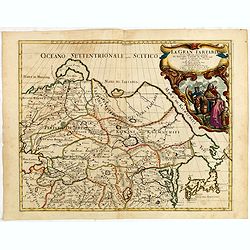
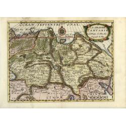
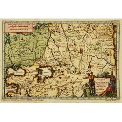
La Grande Tartarie. . .
Map of Tartary which incorporates the current areas of Siberia, Turkestan (including East Turkestan), Greater Mongolia, Manchuria prepared by N.Sanson and published by Pi...
Place & Date: Paris, P. Mariette, 1667
Selling price: $80
Sold in 2009
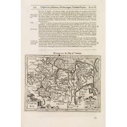
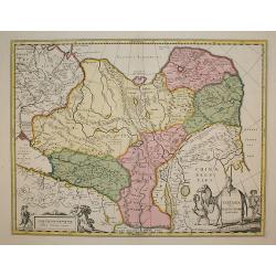
Tabula Tartariae et majoris partis regni Chinae.
Map of China With Japan.
Place & Date: Amsterdam, 1670
Selling price: $200
Sold in 2013
Tartarie.
Uncommon miniature map of Tartary and Tibet, from Pierre Duval's La Geographie Universeille dated 1676. Following his Cartes de geographie in 1657, Pierre Duval published...
Place & Date: Paris, 1676
Selling price: $95
Sold in 2009
A newe map of Tartary.
One of the most decorative "carte à figures"- maps of Tartary, known for its figured borders with costume figures, while above are vignettes of the cities of A...
Place & Date: London, 1626-1676
Selling price: $1800
Sold in 2013
A Newe Mape of Tartary by John Speed.
Map of the Russian Empire, engraved by Dirck Gryp for Speed's 'Prospect of the… World'Carte-a-figure map of Asia from Moscow in the west to the Pacific Ocean in the eas...
Place & Date: London, Basset & Chiswell, 1676
Selling price: $900
Sold in 2014
Tabula Tartariae et majoris partis Regni Chinae . .
Strapwork title cartouche with two putti and a compass rose embellish the map. De Wit's map of NE Asia, extending from the Island of Formosa, the Gandgers and the eastern...
Place & Date: Amsterdam, 1680
Selling price: $250
Sold in 2014
Kingdoms of Tartaria.
Titled Tartary in the cartouche ‘A General Mapp of the Kingdoms of Tartaria. Designed by Monsieur Sanson’ engraved by Thomas Burnford, after the map by Nicolas Sanson...
Place & Date: London, 1680
Selling price: $300
Sold in 2018
Tabula Tartariae et majoris partis regni Chinae.
Stretching from the Caspian Sea in the west to Formosa in the south-east. Including the peninsula of Korea, Japan, Taiwan and the east coast of Yedso. Decorated with fine...
Place & Date: Amsterdam, 1680
Selling price: $30
Sold in 2018
Tabula Tartariae et majoris partis Regnis Chinae.
A very decorative early map extending from the Caspian Sea until Japan, including China and Formosa. With a curious shape of eastern Russia without Kamchatka. Yedso is sh...
Place & Date: Amsterdam, ca 1680
Selling price: $135
Sold in 2019
![[Lot of 3 maps] Tabula Tartariae et Regni China.](/uploads/cache/100353-(2)-250x250.jpg)
[Lot of 3 maps] Tabula Tartariae et Regni China.
Frederick de Wit (1610-1698) became after the closing of the Blaeu firm one of the most important Amsterdam-based publishers. He published several atlases, Atlas Minor (1...
Place & Date: c. 1680
Selling price: $235
Sold in 2022
Tartaria Maior.
A map by Nicolas Sanson of Tartary Major. A region that includes Russia to the west across to Cathay in northern China in the east. It also covers Uzbekistan, Tibet, Zaga...
Place & Date: Paris, ca 1680
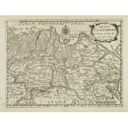
Groot Tartaryen.
Engraved by A.Winter. In lower right hand corner Korea depicted as an island.
Place & Date: Utrecht, 1683
Selling price: $60
Sold
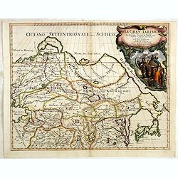
La Gran Tartaria divisa nelle sue parti pricipali da Giacomo
In upper right hand corner a large title cartouche with dedication to Tavernier and Thévenot. The cartographer was Giacomo Cantelli (1643-1695) who was active in Modena ...
Place & Date: Rome, 1683
Selling price: $800
Sold in 2014
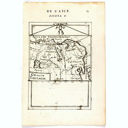
Grande Tartarie (de L'Asie / Figure V).
A fine and uncommon early 17th century map of Tartary with Korea.From the French text edition of "Description d'Univers", 1683. by Allain Manneson Mallet (1630-...
Place & Date: Paris, 1683
Selling price: $60
Sold
Tabula Tartariae et majoris partis Regni Chinae
Nice map of the region from the Caspian Sea through China and Japan. Eastern Russia is truncated with no Kamchatka peninsula and Yedso is shown according to the voyages o...
Place & Date: Amsterdam 1685
Selling price: $250
Sold
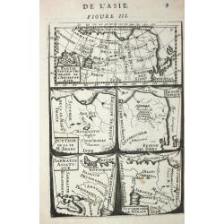
Partie septentrionale de l' Ancienne Asie /Scythie de la M. Imaus / Region Serique / Samatie Asiatique / Scythie deca le M.Imaus.
Alain Manneson Mallet (1603-1706) published in 1683 his ' Description de l' Univers' in 5 volumes. In 1686 a German edition appeared.5 little maps on one sheet
Place & Date: Paris, 1686
Selling price: $50
Sold in 2008
La gran tartaria...
Giacomo Rossi's fine late 17th century map of Tartary. Issued in Il Mercurio geografico In upper right corner a tittle cartouche. The cartographer was Giacomo Cantelli da...
Place & Date: Rome, 1683-1688
Selling price: $500
Sold in 2015
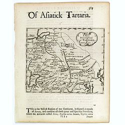
A New Description of Tartarie.
A pleasing small map of Tartary (northeastern Russia and China) showing mountains, Caspian Sea, Lakes and rivers, and The Great Wall of China, towns and cities.This lovel...
Place & Date: London, c 1688
Selling price: $75
Sold in 2017
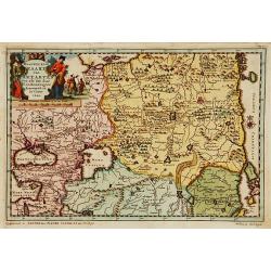
Magnae Tartariae Magni Mogolis Imperii Japoniae et Chinae.
The map stretches from the Caspian Sea in the West to Formosa and Japan in the East. Korea rightly correctly depicted as a peninsula.With decorative title cartouche held ...
Place & Date: Amsterdam 1690
Selling price: $375
Sold
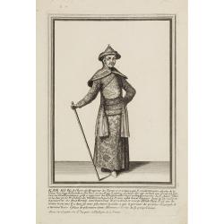
Kam Hi Fils de Chien chi Empereur des Tartares orientaux?.plusieurs titres d'honneur Ecrits de sa propre main.
Very rare and decorative costume plate. Underneath the plate a descriptive text in French.Bears the address : Aparis Chez Langlois rue St.Jacques a l'Enseigne de la Victo...
Place & Date: Paris, ca. 1690
Selling price: $200
Sold
Casan Tartarorum.
An early of Kasan in Russia. The Volga river to the lower left. Engraved by O. Koch. From the scarce Hamburg edition "Viel Vermehrte Moscowitische und Persianische ...
Place & Date: Hamburg, 1696
Selling price: $450
Sold in 2013
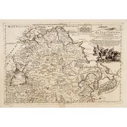
Tartaria, sive magni chami imperium ex credendis. . .
This map is particularly significant for its depiction of Russia, Siberia, and parts of Chinese Tartary, taken from the great six-sheet map by Nicolas Witsen, 1687. The i...
Place & Date: Amsterdam, 1699
Selling price: $150
Sold in 2016
Magnae Tartariae Magni Mogolis Imperii Japoniae et Chinae..
The map stretches from the Caspian Sea in the West to Formosa and Japan in the East. Korea rightly correctly depicted as a peninsula. With an over-sized Taiwan. It has be...
Place & Date: London, 1700
Selling price: $1200
Sold in 2009
La Grande Tartarie
Attractive map of Siberia, northern China, and Korea, which is shown here as an island. The cities, mountains, forests and rivers are well-detailed. Siberia still reflect...
Place & Date: Amsterdam, 1700
Selling price: $80
Sold in 2008
Tartaria sive Magni Chami Imperium
Being one of the most remote regions of Asia, it was among the last to be properly explored and mapped. This map combines the knowledge obtained by the English and Dutch ...
Place & Date: Amsterdam, 1700
Selling price: $250
Sold in 2009
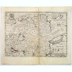
A New Map of Great Tartary and China with the adjoining parts of Asia...
Two insets showing the land to the north-east of China according to the Jesuits. Map stretches from northern Russia and Nova Zemlya in the north-west to Formosa in the so...
Place & Date: Oxford, 1700
Selling price: $195
Sold in 2018
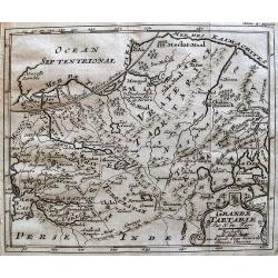
Grande Tartarie.
Map of Tartary covering present-day Asian Russia.
Place & Date: Paris, c.1704
Selling price: $43
Sold in 2010

Grande Tartarie.
A lovely small map of Greater Tartary in Russia, and on into Asia, including Tibet, Usbec, China and Korea. Each region depicted is with a different outline color. A smal...
Place & Date: Madrid, ca. 1696-1704
Selling price: $110
Sold in 2017
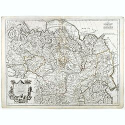
Tartaria, sive magni Chami Imperium ex credendis amplissimi viri Nicolai Witsen. . .
This map is particularly significant for depicting Russia, Siberia, and parts of Chinese Tartary, taken from the great six-sheet map by Nicolas Witsen, 1687. The importan...
Place & Date: Amsterdam, 1705
Selling price: $1350
Sold in 2010

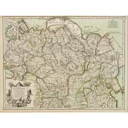
Carte de Tartarie..
Detailed map covering north east Asia, Tibet, Korea and part of Terre d' Eso . Nova Zembla joined with the mainland.
Place & Date: Paris 1706
Selling price: $150
Sold
Carte de Tartarie. . .
Uncommon Amsterdam edition covering north east Asia, Tibet, Korea and part of Terre d'Eso . Nova Zembla joined with the mainland.
Place & Date: Amsterdam, 1706
Selling price: $400
Sold in 2017
Carte de Tartarie. . .
Covering north east Asia, Tibet, Korea and part of "Terre d'Eso". Nova Zembla joined with the mainland.With good detail in Korea, several cities a labeled: Chau...
Place & Date: Paris, 1706
Selling price: $220
Sold
Carte de Tartarie . . .
Uncommon edition with the address : A Paris Chez l’Auteur sur le Quai de l’Horloge a l’Aigle d’Or avec Privilege, 1706". In early 1708 Delisle changed the si...
Place & Date: Paris, 1706
Selling price: $310
Sold in 2018
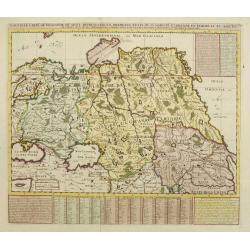
Kaart van Tartaryen.
A fine detailed map of Ukraine, the Crimea and the north-eastern part of the Caspian Sea. With charming pictorial title piece on the lower right-hand corner.Although not ...
Place & Date: Leiden 1707
Selling price: $120
Sold
Naaukeurige kaart van Tartaryen.
A fine detailed map of Ukraine, the Crimea and the north-eastern part of the Caspian Sea. With charming pictorial title piece on the upper left-hand corner.Although not r...
Place & Date: Leiden 1707
Selling price: $120
Sold
La Gran Tartaria descritta secondo le relationi ..
Prepared by De Fer. Including Korea and Japan. A peninsula protrudes out of Tartary and is called Yupi and is separated from Honshu by the Strait of Zungar (Tsugaru). Rar...
Place & Date: Napels, 1717
Selling price: $2200
Sold
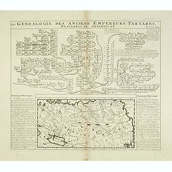
Genealogie des anciens empereurs Tartares,. . .
In lower part a map Russia including Tartary (158 x 290mm.) flanked by text in French. In top a family tree of the descendants of Genghis Khan.From Chatelain's "Atla...
Place & Date: Amsterdam, 1719
Selling price: $110
Sold in 2012
Magnae Tartariae Magni Mogolis Imperii Japoniae et Chinae
The map stretches from the Caspian Sea in the West to Formosa and Japan in the East. Korea rightly correctly depicted as a peninsula.With decorative title cartouche held ...
Place & Date: London 1720
Selling price: $500
Sold
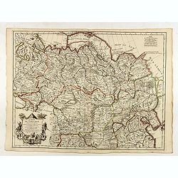
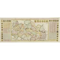
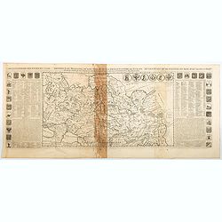
Nouvelle Carte de Moscovie où sont representés les differents etats de sa Maiesté Czarienne..
Map of Russia Tartary and part of China with key tables to the towns. Depicting the different states belonging to the Czar in Asia and Europe, showing the path of one of ...
Place & Date: Amsterdam, ca. 1720
Selling price: $190
Sold
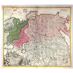
Carte generale des Etats du Czar. Empereur de Moscovie, ou L'on voit ce que ce prince possede en Europe ..
Impressive map of Russia Tartary and part of China with key tables to the towns. Depicting the different states belonging to the Czar in Asia and Europe, showing the path...
Place & Date: Amsterdam, ca. 1720
Selling price: $550
Sold
Carte generale des Etats du Czar. Empereur de Moscovie, ou L'on voit ce que ce prince possede en Europe ..
An impressive map of Russian Tartary and part of China with key tables to the towns. Depicting the different states belonging to the Czar in Asia and Europe, showing the ...
Place & Date: Amsterdam, ca 1720
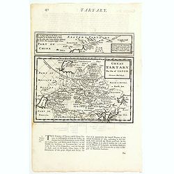
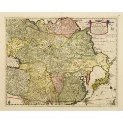
Great Tartary, The Isle of Japan.
A nice copper engraved map of Northern Asia and Japan. It extends from the Caspian Sea and "Part of Moscovy or Russia" in the west to China in the east, northwa...
Place & Date: London, ca 1723
Selling price: $17
Sold in 2021
Generalis Totius Imperii Russorum Novissima Tabula.
Highly detailed map of the Russian Empire and northern China covering the region from Finland and the Black Sea to Kamchatka. It is from the beginning of the period when ...
Place & Date: Nuremberg, 1725
Selling price: $130
Sold in 2016