![[Holy Land, Cyprus]](/uploads/cache/84451-250x250.jpg)
[Holy Land, Cyprus]
Attractive colored woodcut map showing the Holy Land with Cyprus. With a ship and a sea monster. From a Latin edition of Cosmographia by Sebastian Munster.
Place & Date: Petri, Basle, 1550 ca.
Selling price: $175
Sold in 2020
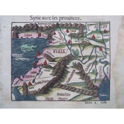
Cyprus/Near East, & text on Cyprus. - Syrie avec les prouinces
Antique woodcut map of Cyprus + the Near East by Sebastian Münster, [In letter-text above the map:] Syrie avec les prouinces. Together one more text sheet on Cyprus ['...
Place & Date: BASEL, ca 1550
![Von den Laendern Asie [Palestine]](/uploads/cache/18623-250x250.jpg)
Von den Laendern Asie [Palestine]
Sebastian Münster, 1489-1552, outstanding geographer of Basle. Editied Ptolemy's atlas ' Geographia Universalis', editions 1540,-42, -45, -51 and -52. Published his &quo...
Place & Date: Basle, 1550
Selling price: $200
Sold
-250x250.JPG)
Cyprus, L'Isle de Cypre
Antique woodcut map of Cyprus by Sebastian Münster, [In letter-text above the map:] L'isle de Cypre.Probably the oldest obtainable map showing Cyprus only.On the back...
Place & Date: BASEL, ca 1550
![[Lot of 2 leaves with map of Cyprus]](/uploads/cache/48277-250x250.jpg)
[Lot of 2 leaves with map of Cyprus]
Two printed text leaves relating to Cyprus with a map (10 x 15 cm). From the 1552 Latin text edition of Münster's Cosmographia, which is a short and complete summary of ...
Place & Date: Basel, 1552
Selling price: $58
Sold in 2022
![[Cyprus].](/uploads/cache/41984-250x250.jpg)
[Cyprus].
Woodcut Ptolemaic-style map by Sebastian Münster figuring Cyprus, published in the edition of Strabo by Henri Petri in 1571."Strabonis rerum geographicarum" is...
Place & Date: Basle, Henri Petri, 1571
Selling price: $180
Sold in 2018
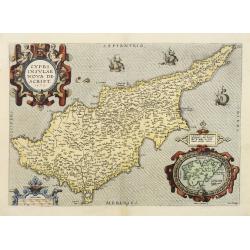
Cypri insulae nova descript.
A milestone in the history of cartography of Cyprus, based on a 1570 map by Giacomo Franco. The map is embellished by sailing ships and a sea monster, bearing a map of Le...
Place & Date: Antwerp, 1573
Selling price: $1200
Sold in 2020
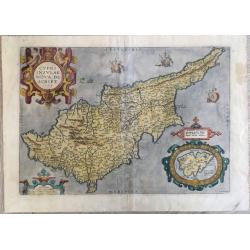
Cypri Insulae Nova descript. 1573.
This is a beautiful copy of a classic map of Cyprus. It is the earliest obtainable version of the best map of Cyprus made to date. Ortelius based his map upon that publis...
Place & Date: Antwerp, 1574
Selling price: $2700
Sold in 2011
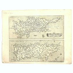
Cyprus Insula / Candia, Olim Creta.
Two maps on one sheet. Copper engraving illustrating Cyprus and Crete, with Latin text on verso. From 1584 onwards editions of the Ortelius atlas no longer included this ...
Place & Date: Antwerp, 1575
![[Cyprus]](/uploads/cache/92347-250x250.jpg)
[Cyprus]
Very early map of Cyprus, by Sebastian Münster from his Cosmographia. On a full sheet with text on both sides in German, and a print of deer.
Place & Date: Basel, 1550-1580
Selling price: $80
Sold in 2013