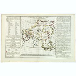
Description Generale de L'Asie.
A basic map of Asia published in the 'Atlas Methodique et Elementaire de Geographie et d'Histoire'. Textural information in French flanking the map. De Mornas was Geograp...
Place & Date: Paris, ca. 1761-62
Selling price: $45
Sold in 2017
Four text page with large intitials.
Four text leaves from the Strasburg edition of Ptolemy's atlas edited by Laurent Fries. On VERSO and RECTO 6-lines initials.Each page side has in top a large woodcut titl...
Place & Date: Strassburg 1525
Selling price: $35
Sold
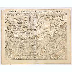
India extrema XXIIII Nova Tabula. (Asia)
One of the first European maps of Asia. Although quite crude, Münster's map does significantly improve upon the Ptolemaic model for the area. The coast of China begins t...
Place & Date: Basel, Heinrich Petri, 1545
Selling price: $800
Sold in 2014
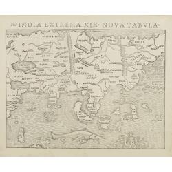
India extrema XIX Nova Tabula.
One of the first European maps of Asia. Although quite crude, Münster's map does significantly improve upon the Ptolemaic model for the area. The coast of China begins t...
Place & Date: Basle, c.1550
Selling price: $1400
Sold
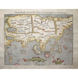
Tabula orientalis regionis, Asiae sciliset extremas complectens terras et regna.
This is one of the earliest maps of the whole continent of Asia, based on the recent geographical discoveries by Portuguese navigators.The outline of the Asian mainland i...
Place & Date: Basle, 1550
Selling price: $1600
Sold in 2013
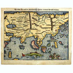
Die lander Asie nach irer gelegenheit biss in Indiam werden in diser tafel verzeichnet.
One of the first European maps of Asia. Although quite crude, Münster's map does significantly improve upon the Ptolemaic model for the area. The coast of China begins t...
Place & Date: Basle, c.1550
Selling price: $1150
Sold in 2014
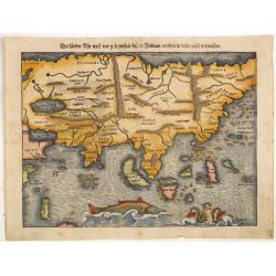
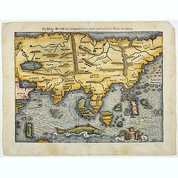
Die länder Asie nach irer gelegenheit biss in Indiam werden in diser tafel verzeichnet.
One of the first European maps of Asia. Although quite crude, Münster's map does significantly improve upon the Ptolemaic model for the area. The coast of China begins t...
Place & Date: Basle, c.1550
Selling price: $1500
Sold in 2016
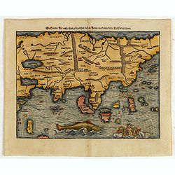
Die länder Asie nach irer gelegenheit biss in Indiam werden in disser tafel verzeichnet
This is one of the earliest maps of the whole continent based on the recent geographical discoveries by Portuguese navigators..The outline of the Asian mainland is relati...
Place & Date: Basle, 1550
Selling price: $750
Sold in 2015
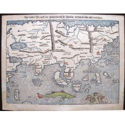
Die länder Asie nach irer gelegenheit biss in Indiam werden in diser tafel verzeichnet..
One of the first European maps of Asia. Although quite crude, Münster's map does significantly improve upon the Ptolemaic model for the area. The coast of China begins t...
Place & Date: Basle, c.1550
Selling price: $1700
Sold in 2017
Die länder Asie nach irer gelegenheit biss in Indiam werden in diser tafel verzeichnet.
One of the first European maps of Asia. Although quite crude, Münster's map does significantly improve upon the Ptolemaic model for the area. The coast of China begins t...
Place & Date: Basle, c.1550
Selling price: $1500
Sold in 2021