Browse Listings in America > Pacific Ocean
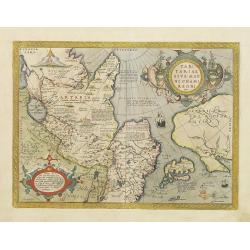
Tartariae sive Magni Chami Regni typus.
Much of the information shown on this map relates to the travels of Marco Polo between 1275 and 1291 with later information gained from the Portuguese Jesuit missionaries...
Place & Date: Antwerp 1584
Selling price: $1600
Sold
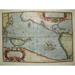
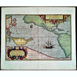
Maris Pacifici.
The first printed map of the Pacific. Acknowledged to be one of the most beautiful and decorative maps which appeared in the Theatrum Orbis Terrarum, it was also one of t...
Place & Date: Antwerp 1589
Selling price: $6050
Sold
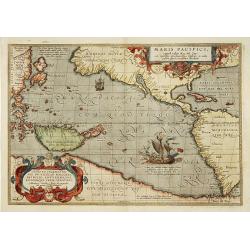
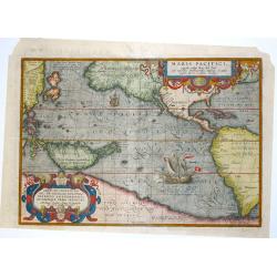
Maris Pacifici.
"This was the first printed map to be devoted solely to the Pacific, and the first to name North and South America separately. It includes most of North and South Am...
Place & Date: Antwerp 1595
Selling price: $7525
Sold
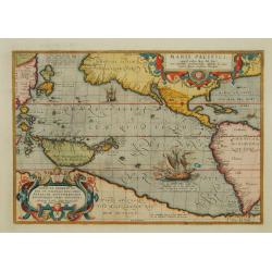
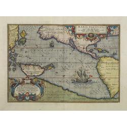
Maris Pacifici.
This was the first printed map to be devoted solely to the Pacific, and the first to name North and South America separately. It includes most of North and South America,...
Place & Date: Antwerp 1595
Selling price: $6150
Sold
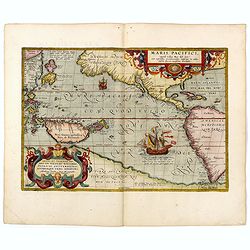
Maris Pacifici.
This was the first printed map to be devoted solely to the Pacific, and the first to name North and South America separately. It includes most of North and South America,...
Place & Date: Antwerp, 1601
Selling price: $2500
Sold in 2013
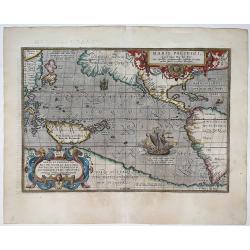
Maris Pacifici.
This was the first printed map to be devoted solely to the Pacific, and the first to name North and South America separately.From the rare Spanish text edition, printed i...
Place & Date: Antwerp, 1602
Selling price: $7500
Sold in 2009
Maris Pacifici, (quod vulgo Mar del Zur) cum regionaribus circumiacentibus, insulisque in eodem passim sparsis, novissima descripto.
This was the first printed map to be devoted solely to the Pacific, and the first to name North and South America separately. It includes most of North and South America,...
Place & Date: Antwerp, 1590-1603
Selling price: $5200
Sold in 2020
Maris Pacifici, (quod vulgo Mar del Zur) ...
The first printed map of the Pacific Ocean. Date on the map: 1589, first published 1590. Based on Mercator's world map of 1569. This was the first map to focus on the Pac...
Place & Date: Antwerp, 1589 / 1603
Selling price: $4600
Sold in 2022
Maris Pacifici.
Splendid map by Ortelius.This was the first printed map to be devoted solely to the Pacific, and the first to name North and South America separately. It includes most of...
Place & Date: Antwerp, 1609
Selling price: $6190
Sold in 2015
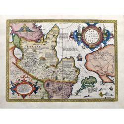
Tartariae sive Magni Chami Regni typus.
The famous and important map of Tartary, Japan, and the west coast of North America, from Ortelius' Theatrum Orbis Terarrum, the first modern atlas of the World.This map ...
Place & Date: Antwerp, 1609
Selling price: $959
Sold in 2020