Browse Listings in America > North America > Western America / Texas
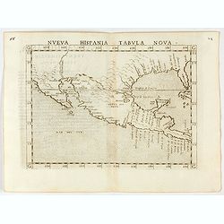
Nueva Hispania tabula nova.
Uncommon first edition of this early map of New Spain, Florida and Gulf of Mexico. The map is an enlarged version of Giacomo Gastaldi's map published in 1548. Nomenclatur...
Place & Date: Venice, 1561
Selling price: $1000
Sold in 2024
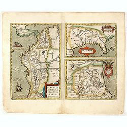
La Florida/ Peruviae Auriferae regionis Typus/ Guastecan.
The Chaves map of Florida is a prime example of an explorer's map since it records the recent discoveries of Cabeza de Vaca, De Soto, and Moscoso. The map revealed little...
Place & Date: Antwerp, 1592
Selling price: $1200
Sold in 2016
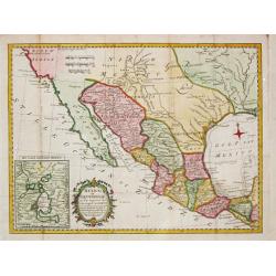
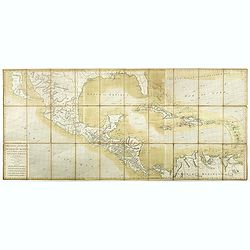
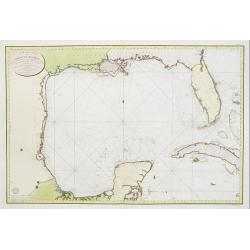
![[Gulf of Mexico showing entire Texas coast, and extending east to Florida]](/uploads/cache/37159-250x250.jpg)
[Gulf of Mexico showing entire Texas coast, and extending east to Florida]
Untitled sheets from Ottens’ important 6-sheet wall map: "Grand Théâtre de la Guerre en Amérique suivant les plus nouvelles observations des Espagnols, Anglois,...
Place & Date: Amsterdam, 1741
Selling price: $2100
Sold in 2016
Mexico of Nieuw Spanje.
A map of Mexico and Texas ( called Tecas) from the Dutch edition of Robertson's ' History of America'.
Place & Date: Amsterdam, 1778
Selling price: $150
Sold in 2018
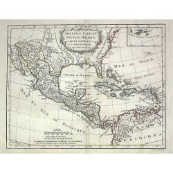
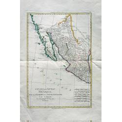
Nouvelle Espagne, Nouveau Mexique, Isles Antilles
Map of the 18th century Spanish territories of New Spain and New Mexico together with islands of the Caribbean. Accurate coastlines and good delineation of the rivers alo...
Place & Date: Paris, 1778
Selling price: $165
Sold in 2009
Carte des Isles Antilles et du Golfe du Mexique, avec la Majeure partie de la Nouvelle Espagne. Par M. Bonne, Inge´nieur Hydrographe de la Marine. Aoust 1780. . .
The first edition of this scarce large format map of Florida, the Gulf Coast, Texas (almost to Corpus Christi), Mexico, Baja California and Central America, northern Sout...
Place & Date: Paris, 1780
Selling price: $2200
Sold in 2022
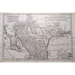
Le Nouveau Mexique, Avec La Partie Septentrionale De L'Ancien, ou De La Nouvelle Espagne.
Highly detailed map of the Southwest USA, from Baja California to West Florida, including parts of Mexico and a tip of Yucatan. With very interesting features: In Texas,...
Place & Date: Paris, 1780
Selling price: $55
Sold in 2015
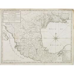
L'Ancien et le Nouveau Mexique avec la Floride et la Basse Louisiane. Partie Occidentale.
Excellent early map of California, Texas, Arizona, New Mexico, and Mexico. Very detailed with many towns, jesuit missions, forts, Indian areas, etc. Early geography of in...
Place & Date: Paris, c 1780
Selling price: $120
Sold in 2010
Carte d\'une partie de l\'Amerique.. et de la Louisiane..
A handsome and seldom-seen map of the Spanish colonial period. Included in Voyages de Mr. de Pagés.De Pages, a French nobleman and Navy captain, crossed the \"Provi...
Place & Date: Paris, 1782
Selling price: $700
Sold in 2008
Carte des cotes du Golfe du Mexique..
Detailed and important early chart of the Gulf Coast and Florida and dated 1800. From Neptune des cotes occidentales d'Amerique sur le Grand Ocean, an extensive atlas of ...
Place & Date: Paris 1800
Selling price: $1750
Sold