Browse Listings in America > North America > New England states / Vermont / Maine
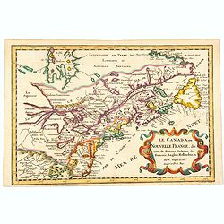
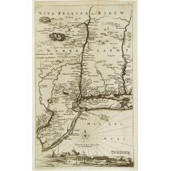
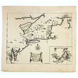
Le Canada, ou Nouvelle France, &c, tiree de diverses Relations des Francois, Anglois, Hollandois, &c. . .
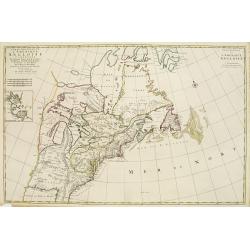
A fine smaller map of the north eastern US seaboard, extending to the Great Lakes (shown as open-ended) and beyond into 'Upper Canada' by Nicolas Sanson, and originally f...
Place & Date: Utrecht, 162
Selling price: $420
Sold in 2021
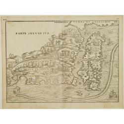
Nova Francia.
RARE FIRST STATE of the woodcut map of the Atlantic coastline from New York to Labrador. Manhattan as the peninsula "Angouleme", named after King Francis I, Duk...
Place & Date: Venice 1556
Selling price: $5100
Sold

Tierra Nueva.
Uncommon first edition of this early map of the east coast is an enlarged version of Giacomo Gastaldi map published in 1548. Nomenclature and cartography are unchanged, w...
- $1000 / ≈ €936
Place & Date: Venice, 1561
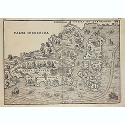
La Nuova Francia.
Second state of the woodcut map of the Atlantic coastline from New York to Labrador. Manhattan as the peninsula "Angouleme", named after King Francis I, Duke of...
Place & Date: Venice, 1565
Selling price: $2800
Sold in 2012
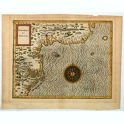
Norumbega et Virginia.
An important map that shows the east coast of North America from the Outer Banks of present day Carolina and on up to Canada. Chesapeake Bay is called "Chesipooc Sin...
Place & Date: Douai, 1607
Selling price: $2050
Sold in 2020
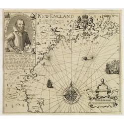
New England/ Die mercklichsten dheile. .
Hulsius used the first state of Smith's New England map published the previous year in London. The most noticeable differences, however, are the lack of any imprints lowe...
Place & Date: Frankfurt ,1617
Selling price: $8100
Sold in 2012
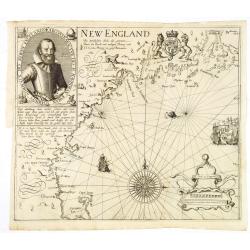
Die Mercklichsten Dheile, also Genennet durch den Durchl: und Mechtigen Prinzen und H.H. Carolus, Prinzen von Gross Britannien.
Hulsius used the first state of Smith's New England map published the previous year in London. The most noticeable differences, however, are the lack of any imprints lowe...
Place & Date: Frankfurt, 1617
Selling price: $10000
Sold
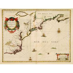
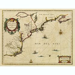
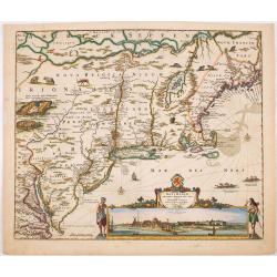
Nova Anglia Novum Belgium et Virginia.
In the 1636 edition of the Appendix , Johannes Janssonius inserted this important and influential map of the eastern seaboard from C. of Feare (Cape Look out) to Nova Sco...
Place & Date: Amsterdam, 1636
Selling price: $2100
Sold in 2019
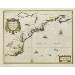
Nova Anglia Novum Belgium et Virginia.
In the 1636 edition of the Appendix , Johannes Janssonius inserted this important and influential map of the eastern seaboard from C. of Feare (Cape Look out) to Nova Sco...
Place & Date: Amsterdam 1636
Selling price: $1800
Sold
Nova Anglia Novum Belgium et Virginia.
In the 1636 edition of the "Appendix," Johannes Janssonius inserted this critical and influential map of the eastern seaboard from C. of Feare (Cape Lookout) to...
Place & Date: Amsterdam, 1636
Selling price: $2100
Sold in 2021

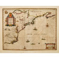
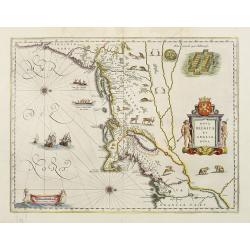
Nova Belgica et Anglia Nova.
Orientated with north to the right. This is one of the earliest maps to concentrate solely on this area of the colonies, excluding Virginia and the extreme north east coa...
Place & Date: Amsterdam, 1638
Selling price: $3300
Sold in 2010
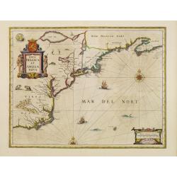
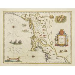
Nova Belgica et Anglia Nova.
Orientated with north to the right. This is one of the earliest maps to concentrate solely on this area of the colonies, excluding Virginia and the extreme north east coa...
Place & Date: Amsterdam, 1638
Selling price: $4000
Sold in 2013
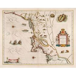
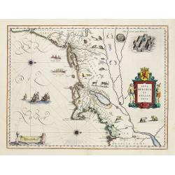
Nova Belgica et Anglia Nova.
Orientated with north to the right. This is one of the earliest maps to concentrate solely on this area of the colonies, excluding Virginia and the extreme north east coa...
Place & Date: Amsterdam, 1640
Selling price: $2200
Sold in 2017
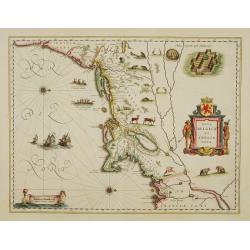
Nova Belgica Et Anglia Nova
An important and early colonial era map of the Dutch and English colonies of northeast America by the renowned 17th century map maker, Willem Janszoon Blaeu. The map is d...
Place & Date: Amsterdam, 1640
Selling price: $1600
Sold in 2023
Nova Belgica et Anglia Nova.
A second state. Derived from De Laet's map of 1630, which was important as the first appearance on a printed map of 'Manhattes' (Manhattan), 'N.Amsterdam' (New York, foun...
Place & Date: Amsterdam 1649
Selling price: $2025
Sold
Nova Belgica et Anglia Nova.
A second state. Derived from De Laet's map of 1630, which was important as the first appearance on a printed map of 'Manhattes' (Manhattan), 'N.Amsterdam' (New York, foun...
Place & Date: Amsterdam 1649
Selling price: $1900
Sold
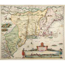
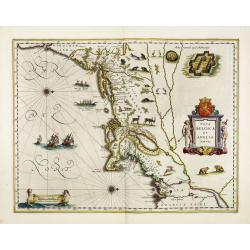
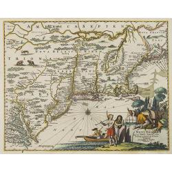
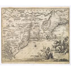
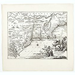
Novi Belgii novae que Angliae nec non partis Virginiae..
The very rare second state: with Fort Kassimier, but without Philadelphia. A classic Dutch map of the east coast from the Chesapeake Bay north to Canada with the famous v...
Place & Date: Amsterdam 1652
Selling price: $5300
Sold
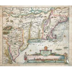
Novi Belgii novaeque Angliae nec non partis Virginiae tabula multis in locis emendata a Iusto Dackers.
This map belongs to the most famous maps of New England. It shows the East coast from the Chesapeake to the St. Lawrence river. The map was firstly published by J. Dancke...
Place & Date: Amsterdam, 1655
Selling price: $1500
Sold in 2014
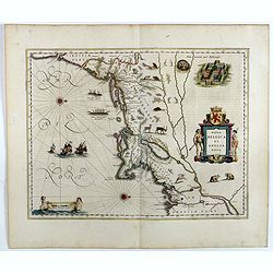
Nova Belgica sive Nieuw Nederlandt.
Extremely rare map of western New England with in bottom a view of Nieuw Amsterdam (New York.). The map accompanies the second edition only of Adriaen van der Donck's Bes...
Place & Date: Amsterdam 1656
Selling price: $13025
Sold
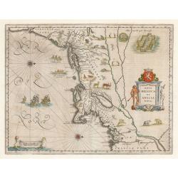
Nova Belgica et Anglia Nova.
Orientated with north to the right. This is one of the earliest maps to concentrate solely on this area of the colonies, excluding Virginia and the extreme north east coa...
Place & Date: Amsterdam, 1658
Selling price: $3600
Sold
Nova Belgica et Anglia Nova.
Orientated with north to the right. This is one of the earliest maps to concentrate solely on this area of the colonies, excluding Virginia and the extreme north east coa...
Place & Date: Amsterdam, 1658
Selling price: $2700
Sold
Nova Belgica et Anglia Nova.
Orientated with north to the right. This is one of the earliest maps to concentrate solely on this area of the colonies, excluding Virginia and the extreme north east coa...
Place & Date: Amsterdam 1661
Selling price: $3550
Sold
Nova Belgica et Anglia Nova.
Orientated with north to the right. This is one of the earliest maps to concentrate solely on this area of the colonies, excluding Virginia and the extreme north east coa...
Place & Date: Amsterdam 1661
Selling price: $3600
Sold
Nova Belgica et Anglia Nova.
Orientated with north to the right. This is one of the earliest maps to concentrate solely on this area of the colonies, excluding Virginia and the extreme north east coa...
Place & Date: Amsterdam 1661
Selling price: $2850
Sold
Novum Amsterodamum..
A good example of one of the earliest available views of New York, from Montanus description of America. Set in a folio page of text describing in glowing terms the attra...
Place & Date: Amsterdam, 1671
Selling price: $900
Sold in 2011
Novi Belgii quod nunc Novi Jorck..
A beautifully engraved map, derived from the highly influential map by Visscher. The decoration of this finely engraved map has in the lower right corner not longer a vie...
Place & Date: Amsterdam, 1671
Selling price: $1300
Sold
Novi Belgii quod nunc Novi Jorck vocatur, Novae q. Angliae & partis Virginiae . . .
A beautifully engraved map, derived from the highly influential map by Visscher. The decoration of this finely engraved map has in the lower right corner not longer a vie...
Place & Date: Amsterdam, 1671
Selling price: $1600
Sold in 2008
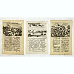
Novum Amsterodamum. . . (together with 2 other scenes in New England)
A good example of one of the earliest available views of New York, from Montanus description of America, taken from a Dutch text edition. Set in a folio page of text desc...
Place & Date: Amsterdam, 1671
Selling price: $330
Sold in 2014
Novi Belgii, quod nunc Novi Jorck vocatur, Novaeque Anglia et partis Virginiae. . .
A beautifully engraved map, derived from the highly influential map by Visscher. The decoration of this finely engraved map has in the lower right corner not longer a vie...
Place & Date: Amsterdam, 1673
Selling price: $1000
Sold in 2016
Novi Belgii, quod nunc Novi Jorck vocatur, Novaeque Angliae & Partis Virginiae Accuratissima et Novissima Delineatio.
A beautifully engraved map of the Northeast, extending from the St. Laurence and New England to the Chesapeake and centered on Long Island, which is still shown as an isl...
Place & Date: Amsterdam, 1673
Selling price: $1000
Sold in 2022
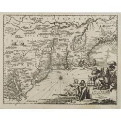
Costes et Rivieres de Virginie, de Mariland et de Nouvelle Angletere. . .
A scarce map that includes the Chesapeake to New England, St. Johns, and Port Royal, showing a single Great Lake "Lake of Herekoys ou Lac des Iroquois." With an...
Place & Date: Paris, Louis Billaine, 1674
Selling price: $500
Sold in 2016
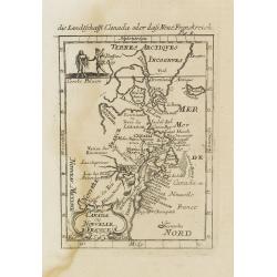
Canada ou Nouvelle France.
A strange early depiction of the Eastern Seaboard, from Terres Arctiques Incognues to Virginie, including also an outline of the Great Lakes. Native Indians appear at the...
Place & Date: Frankfurt, 1684
Selling price: $90
Sold in 2008
Novi Belgii Novaeque Angliae nec non partis Virginiae tabula : multis in locis emendata / per Nicolaum Visscher.
An essential map of the New Netherlands, New England, Pennsylvania, and parts of Maryland and Virginia. Although the map itself is primarily derived from Joannes Janssoni...
Place & Date: Amsterdam, 1684
Selling price: $8000
Sold in 2014
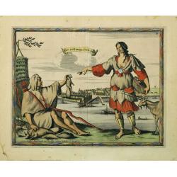
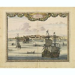
Nieu Amsterdam al. New York.
Engraved by Aldert Meyer for Carolus Allard's for his Orbis habitabilis oppida et vestitus the print shows two locals and a distance view of lower Manhattan. This rare wo...
Place & Date: Amsterdam, c.1685-1690
Selling price: $11000
Sold in 2010
Nieu Amsterdam al. New York.
Engraved by Thomas Doesburgh (active between 1683 and 1714) for Carolus Allard's for his Orbis habitabilis oppida et vestitus the print shows a distance view of lower Man...
Place & Date: Amsterdam, c.1685-1690
Selling price: $1600
Sold in 2011
Carte Nouvelle de L'Amerique Angloise Contenant La Virginie, Mary-Land, Caroline, Pensylvania, Nouvelle Jorck, N. Jarsey, N. France..
A unique map of eastern North America with oversized Great Lakes. Pennsylvania includes both Delaware and eastern Maryland and almost bisects New York. Virginia includes ...
Place & Date: Amsterdam c. 1700
Selling price: $2200
Sold
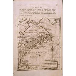
The ENGLISH EMPIRE in America.
Early English map of the British Colonies in North America from Herman Moll's 'A System of Geography' published in 1701. Compass Rose and rhumb lines with text on the rev...
Place & Date: London, 1701
Selling price: $200
Sold in 2015
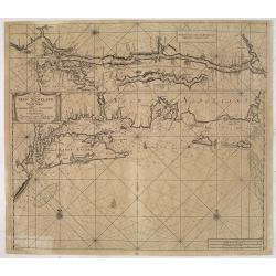
Pas-Kaart Vande Zee Kusten van Niew Nederland Anders Genaamt Niew York. . .
The first separate map of the Hudson River Valley, and the second printed of New York, Long Island and the southern New England coast. Based on original Dutch surveys ma...
Place & Date: Amsterdam, 1682 - ca. 1702
Selling price: $1500
Sold in 2013
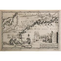
Nieuw Engeland in Twee Scheepstogten door Kaptein Johan Smith in de Jaren 1614 en 1615 Bestevend.
Pieter van der Aa was a prolific publisher. He published a.o. ' Naaukeurige versameling der gedenkwaardigste zee- en land-reysen', a series of accounts of voyages (1706-0...
Place & Date: Leiden, 1707
Selling price: $700
Sold
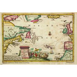
't Noorder Gedeelte van Virginie door Bartholomeus Gosnol en Martin Pringe uyt England bevaaren
Pieter van der Aa was a prolific publisher. He published a.o. ' Naaukeurige versameling der gedenkwaardigste zee- en land-reysen', a series of accounts of voyages (1706-0...
Place & Date: Leiden, 1707
Selling price: $400
Sold in 2018