Browse Listings in America > North America > California / Northwest Central
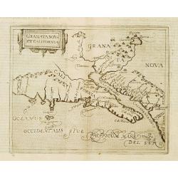
Granata Nova et California.
Very rare sixteenth century map: the second printed map devoted to the California peninsula and the south west of present day United States. A reduced version of the Corn...
Place & Date: Cologne 1598
Selling price: $1600
Sold
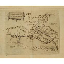
Granata Nova et California.
Very rare sixteenth century map: the second printed map devoted to the California peninsula and the south west of present day United States. A reduced version of the Corn...
Place & Date: Cologne 1598
Selling price: $1900
Sold

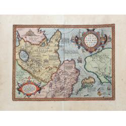
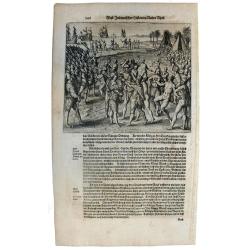
Franciscus Draco cum in locum quendam venis set, à Rege istius regionis convenitur.
This famous and desirable scene was engraved by de Bry native Americans approaching European soldiers and offer gifts. A group of native Americans sit around a fire in a ...
Place & Date: Frankfurt, Matthaeus Becker, 1599
Selling price: $300
Sold in 2014
![Tartariae Sive Magni Chami Regni typus. [Alaska and N.America West coast]](/uploads/cache/84445-250x250.jpg)
Tartariae Sive Magni Chami Regni typus. [Alaska and N.America West coast]
Important Map of Asia and North America Included in the World’s First Modern Atlas. It is the earliest obtainable map to name California and is one of the first to incl...
Place & Date: Antwerp, 1603
Selling price: $700
Sold in 2021
Tartariae sive magni regni...
An attractive old color example of this important map of Tartary, Japan, and the west coast of North America, from Ortelius' Theatrum Orbis Terarrum, the first modern at...
Place & Date: Amsterdam, 1608
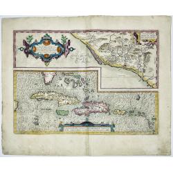
CULIACANAE,A MERICAE REGIO NIS, DESCRIPTIO - Hispaniolae, Cubae, Aliarumique Insularum Circumiacientium Delineatio
CULIACANAE, A MERICAE REGIO NIS, DESCRIPTIO - Hispaniolae, Cubae, Aliarumique Insularum Circumiacientium Delineatio.Antique map of the Caribbean. Two maps on one sheet: ...
Place & Date: Antwerp, 1603-1612
Selling price: $400
Sold in 2023

Tartariae sive Magni Chami Imperium.
This is a very early depiction of the northern Pacific, with the first mapping of Northwest Coast of America and probably the first map to name California 'C. Califormio...
- $2500 / ≈ €2339
Place & Date: Antwerp, c. 1608-1612
![[Sir F. Drake crowned by the Indians of Nova Albion] / [Europeans, Drake, and the King of Ternate].](/uploads/cache/41100-250x250.jpg)
[Sir F. Drake crowned by the Indians of Nova Albion] / [Europeans, Drake, and the King of Ternate].
First engraving: Native Americans approach European soldiers and offer gifts. A native king or ruler wearing a feathered headdress puts a crown on a man's head who holds ...
Place & Date: Frankfurt, M.Merian, 1633
Selling price: $90
Sold in 2018
Sir Francis Drake crowned King of California.
Rare 1655 view of Sir Francis Drake, English soldiers paraded and planting the flag while native Californians celebrate and place a crown on Drake's head. From "Newe...
Place & Date: Frankfurt, 1655
Selling price: $350
Sold in 2015
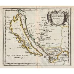
Audience de Guadalajara, Nouveau Mexique, Californie, &c.
Map of California, shown as an island, from the first edition of the atlas L'Amérique en plusieurs cartes, et en divers traittés de Géographie, et d'Histoire.Nicolas S...
Place & Date: Paris, 1657
Selling price: $1400
Sold in 2012