Browse Listings in America > Caribbean & Atlantic Ocean
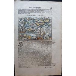
Discovery of America.
The discovery of America by Christopher Columbus from the Cosmographia by Sebastian Münster (ca 1544), on a full leaf. A second full leaf is added with the description o...
Place & Date: Basel, 1544
Selling price: $120
Sold in 2020
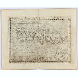
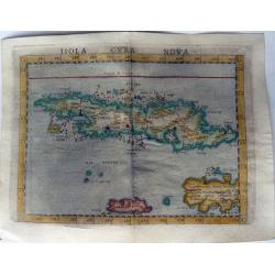
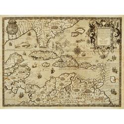
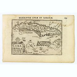
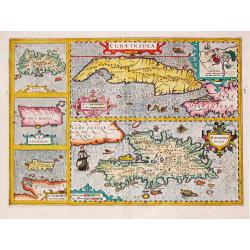
Insula Cuba Nova.
One of the earliest separately published maps of Cuba, with the Yslas de Lagartos (Cayman Islands). The map includes early appearances of Iamayea (Jamaica), Isola Espanol...
Place & Date: Venice, 1548
Selling price: $900
Sold in 2021
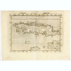
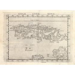
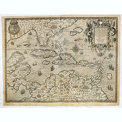
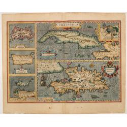
Isola Cuba Nova.
Scarce FIRST edition of this map depicting the island of Cuba - one of the earliest separately published maps of Cuba. Also includes Jamaica and northwestern Hispaniola a...
Place & Date: Venice, 1561
Selling price: $300
Sold in 2020
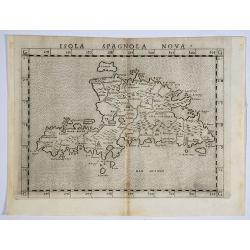
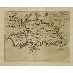
Isola Spagnola Nova.
One of the earliest separately published maps of Hispaniola, from an early edition of Ruscelli's version of Ptolemy's Geography, published in 1561. Ruscelli's map is a la...
Place & Date: Venice, 1562
Selling price: $70
Sold in 2019
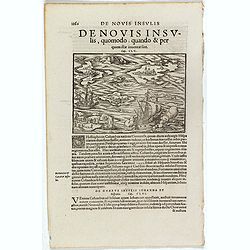
De Novis Insulis, Quomodo quando . . .
Text page with a map of unspecified islands in the New World (140 x 145 mm). with sea monsters on the recto. From Münster's Cosmographia Universalis.The Cosmographia by ...
Place & Date: Basle, ca. 1564
Selling price: $50
Sold in 2017
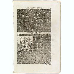
De Navigatione Maris.
One Latin text page about navigation, early voyages, and illustrated with a ship (68 x 64 mm), who was lateron used to illustrate Christopher Columbus ship. On verso an i...
Place & Date: Basle, ca. 1564
Selling price: $10
Sold in 2018
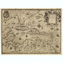
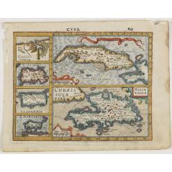
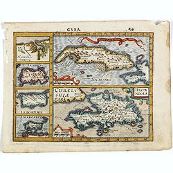
Isola Cuba Nova
This important Ruscelli map of Cuba from his work La Geografia di Claudio Tolomeo Alessandrino, is based on Gastaldi’s earlier map of the same region, dated 1548. Altho...
Place & Date: Venice, 1570
Selling price: $375
Sold in 2023
ISOLA CUBA NOVA.
One of the earliest separately published maps of Cuba. Also includes Jamaica and northwestern Hispaniola and the Cayman Islands. The map is elegantly designed and engrave...
Place & Date: Venice, 1574
Selling price: $1400
Sold in 2021
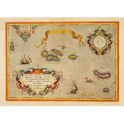
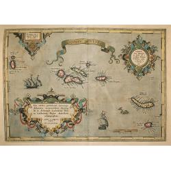
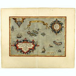
Açores Insulae.
The importance of the Azores at that time was connected with the observation of Columbus that compass variation (i.e. the difference between the real and the magnetic nor...
Place & Date: Antwerp, 1580
Selling price: $1000
Sold in 2015
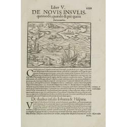
Liber V. De Novis insulis quomodo, quando & per quem illae inuentae sint.
Map of unspecified islands in the New World, printed area 105 x 160mm, set in a large page of text. From an Latin text edition of the Cosmography. One of the earliest obt...
Place & Date: Basle, c. 1580
Selling price: $100
Sold in 2009
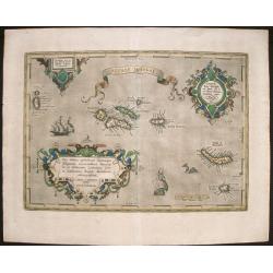
Açores Insulae.
First state. The importance of the Azores at that time was connected with the observation of Columbus that compass variation (i.e. the difference between the real and the...
Place & Date: Antwerp, 1584
Selling price: $900
Sold in 2014
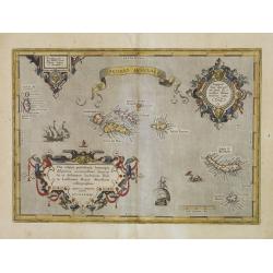
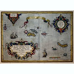
Açores Insulae. . .
Three cartouches of exceptional beauty decorate this artistic map. A beautifully engraved chart of the Azores based on Luis Teixeira's cartographic work with two ornate t...
Place & Date: Antwerp, 1584
Selling price: $310
Sold in 2015
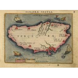
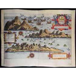
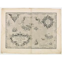
Tercera Insula
Nice miniature map showing the island and the important port of Angra. The map is beautifully engraved with stippled seas and two sailing ships and two tiny sea monsters.
Place & Date: Antwerp, 1588
Selling price: $50
Sold
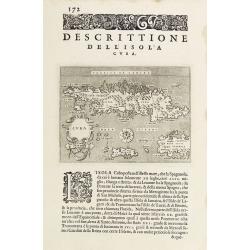
Descrittione dell'Isola Cuba.
Early map of Cuba, published in Venetia, Appresso gli Heredi di Simon Galignani, 1590.
Place & Date: Venise 1590
Selling price: $225
Sold
![[Cuba]](/uploads/cache/32579-250x250.jpg)
[Cuba]
On recto a wood block printed map of Cuba (79x123mm.).From a Latin text edition of his Geographia , that great compendium of Renaissance knowledge.
Place & Date: Basle, 1550-1590
Selling price: $190
Sold in 2013
Açores Insulae.
The importance of the Azores at that time was connected with the observation of Columbus that compass variation (i.e. the difference between the real and the magnetic nor...
Place & Date: Antwerp, 1592
Selling price: $400
Sold in 2009
Acores Insulae.
Important map of Ortelius of the strategic islands of the Azores, in the 16th century an important hub from the Spanish Americas and the Silver fleet. The observation of ...
Place & Date: Antwerp, 1592
Selling price: $420
Sold in 2018
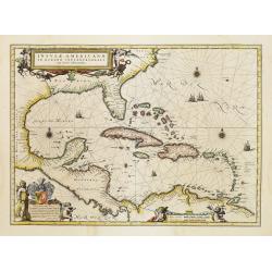
Occidentalis Americae partis..
The most beautifully engraved early map of the Caribbean, including Florida and the Southeast. The map includes representations of Columbus' ships and various notes regar...
Place & Date: Frankfurt 1594
Selling price: $11025
Sold
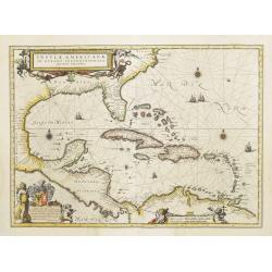
Occidentalis Americae partis.
The most beautifully engraved early map of the Caribbean, including Florida and the South-east. The map includes representations of Columbus' ships and various notes rega...
Place & Date: Frankfurt, 1594
Selling price: $7500
Sold
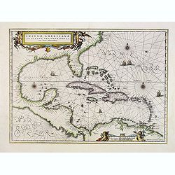
Occidentalis Americae partis..
The most beautifully engraved early map of the Caribbean, including Florida and the Southeast. The map includes representations of Columbus' ships and various notes regar...
Place & Date: Frankfurt 1594
Selling price: $4500
Sold in 2019
![Pisces in mari alati [flying fish attack]](/uploads/cache/48527-250x250.jpg)
Pisces in mari alati [flying fish attack]
Flying fish attacking a Portuguese ship in the West Indian Waters.Read more about "Les Grand Voyages" by Theodore De Bry [+]
- $400 / ≈ €374
Place & Date: Frankfurt, 1594

(Island of Pearls) Perlarum insula ob unionum copiam sic dicta.
A depiction of Cubagua as the Perlarum Insula (Island of Pearls), with in the foreground, two large ships send dinghies toward busy Native Americans collecting pearl oyst...
- $250 / ≈ €234
Place & Date: Frankfurt, 1594
Vera effigies et delineatio Insulae, Ascencio nuncupatae (...) Waerachtighe affbeeldinghe en verthooninghe vant Eylant Asçençion (...)
A rare copper engraved bird's eye view by B. VAN DOETECUM of the island of Ascension in the South Atlantic Ocean. Panorama showing the island in three profile views, engr...
Place & Date: Amsterdam, 1596
Selling price: $375
Sold in 2019
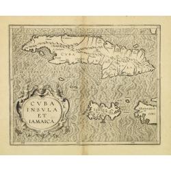
Cuba Insula et Jamaica.
One of only two Caribbean maps in this important work, which was one of the first atlases to provide detailed maps on the individual regions in the New World. The map is ...
Place & Date: Louvain, 1597
Selling price: $300
Sold in 2012
Insula D.Helenae sacra coeli..
A fine perspective view of the Island of St.Helena in the South Atlantic. The location of the Island directly on the navigation route from Europe to the Cape of Good Hope...
Place & Date: Amsterdam 1598
Selling price: $1225
Sold
Hispaniola Insula.
Very rare sixteenth century map of the Hispaniola Island and the eastern tip of Cuba.Published in the German edition of José de Acosta's De Natura Nova Orbis, first publ...
Place & Date: Cologne 1598
Selling price: $600
Sold
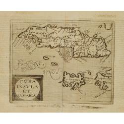
Cuba Insula et Iamaica.
Very rare sixteenth century map of Cuba, in lower part JamaicaPublished in the German edition of José de Acosta's De Natura Nova Orbis, first published in Salamanca, 158...
Place & Date: Cologne 1598
Selling price: $1400
Sold
Açores Insulae.
The importance of the Azores at that time was connected with the observation of Columbus that compass variation (i.e. the difference between the real and the magnetic nor...
Place & Date: Antwerp, 1598
Selling price: $750
Sold in 2019
Açores Insulae.
The importance of the Azores at that time was connected with the observation of Columbus that compass variation (i.e. the difference between the real and the magnetic nor...
Place & Date: Antwerp, 1598
Selling price: $200
Sold in 2020
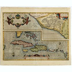
Culiacanae Americae regionis.. / Hispaniolae, Cubae. . .
Two separate virtually identically sized inset maps on one sheet, each with a decorative scroll title cartouche. Culiacanae depicts the coastal and inland western region ...
Place & Date: Antwerp, 1579-1603
Selling price: $600
Sold in 2016
Cuba Insula.
This lovely miniature map shows the Caribbean Islands of Cuba and Jamaica. Published by Petrus Bertius, in Amsterdam at the beginning of the seventeenth century, this map...
Place & Date: Amsterdam, 1606
Selling price: $170
Sold in 2020
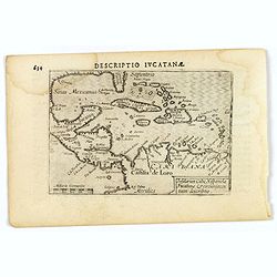
Descriptio Iucatana.
An attractive miniature map of Mexico, Florida, the very north of South America and the Caribbean, published by Petrus Bertius, in Amsterdam at the beginning of the seven...
Place & Date: Amsterdam, 1606
Selling price: $95
Sold in 2019
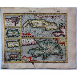
Cuba.
An attractive copper engraved map of Cuba & the Caribbean islands from Mercator's "Atlas Minor", with larger images of Cuba and Hispaniola, and four smaller...
Place & Date: Amsterdam, 1607
Selling price: $85
Sold in 2017
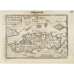
Aity Sive Spaniola.
General map of Hispaniola. Title cartouche on the upper left corner.First published in 1598 in his Caert-Thresoor, the plates were executed by the most famous engravers i...
Place & Date: Amsterdam/Frankfurt 1609
Selling price: $160
Sold
-250x250.jpg)
Hispaniolae, Cubae Alliarumique Insularium
Abraham Ortelius (1527-98), Dutch cartographer and publisher of the first modern atlas, ' Theatrum Orbis Terrarum' in 1570. Editions till 1612. Also an atlas of ancient c...
Place & Date: Antwerp, 1609
Selling price: $250
Sold in 2022
S.Giovanni. (Puerto Rico)
One of the earliest obtainable separate maps of Puerto Rico. Also shows the Virgin Islands, with a large St. Croix (Croce). Includes decorative cartouche, four sea monste...
Place & Date: Venice, 1620
Selling price: $300
Sold in 2013
![A Mapp of the Sommer Islands..[Mappa Aestivarum Insularum]..](/uploads/cache/15769-250x250.jpg)
A Mapp of the Sommer Islands..[Mappa Aestivarum Insularum]..
Title in both English and Latin. English text on verso. The map was beautifully engraved by Abraham Goos in Amsterdam for Speed's Prospect Of The Most Famous Parts Of The...
Place & Date: London 1626
Selling price: $3525
Sold
![[Two items] Abbildung Welcher Gestalt die Spanische Silberflota von dem Hollandischen / Das Eylandt Cuba mit Deroselben Gelegenheit](/uploads/cache/23421-250x250.jpg)
[Two items] Abbildung Welcher Gestalt die Spanische Silberflota von dem Hollandischen / Das Eylandt Cuba mit Deroselben Gelegenheit
An etching showing Piet Heyn going ashore at Cuba on a sheet with letterpress. Together with a scarce engraving of the Dutch and Spanish fleets in Patanca Bay, Cuba illus...
Place & Date: Frankfurt, 1627
Selling price: $650
Sold in 2008
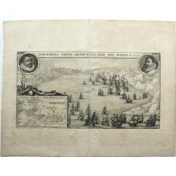
VEROVERING VANDE SILVER-VLOOT INDE BAY MATANCA.
Conquest of the treasure fleet in the Bay of Matanzas by a fleet of the WIC commanded by Admiral Piet Heyn, September 8, 1628. Bottom left a map of the island of Cuba. Ro...
Place & Date: Amsterdam, 1628
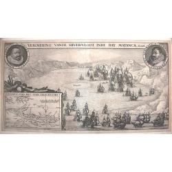
Verovering vande Silver-Vloot inde Bay Matanca. Anno 1628.
A scarce and important depiction of the taking of the Spanish silver fleet by the Dutch naval force in Matanzas Bay, Cuba. It includes the portraits of the Dutch commande...
Place & Date: Amsterdam, 1629
Selling price: $600
Sold in 2015
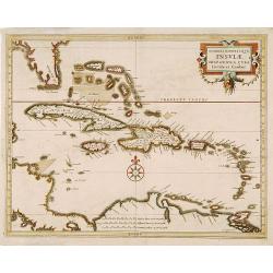
Maiores minores que Insulae Hispaniola, Cuba Lucaia..
Detailed map of the Caribbean, prepared by Hessel Gerritsz, the official map maker for the Dutch West India Company. Gerritsz enjoys a very high reputation for his critic...
Place & Date: Leiden 1630
Selling price: $730
Sold
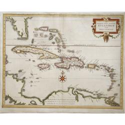
De Groote ende Kleyne Eylanden van West-Indien
This map covers all of the West Indies and the Bahamas and shows the coastline of Florida, Central and South America. The title is contained in a decorative title cartouc...
Place & Date: Amsterdam, 1630
Selling price: $800
Sold in 2008
Cuba Insula, Hispaniola Insula, Ins. Jamaica..
One of the earliest maps depicting five of the major West Indian islands. An inset top right shows Havana. The map is exceptionally attractive and beautifully engraved.
Place & Date: Amsterdam, 1630
Selling price: $750
Sold in 2014
Cuba Insula. Hispaniola.
Decorative engraved map of Cuba above Hispaniola with smaller insets of Havana, Jamaica, Puerto Rico and Margarita.
Place & Date: Amsterdam, ca. 1630
Selling price: $150
Sold in 2015
Cuba Insula. Hispaniola.
Decorative engraved map of Cuba above Hispaniola with smaller insets of Havana, Jamaica, Puerto Rico and Margarita.From the first French-text edition of Jodocus Hondius' ...
Place & Date: Amsterdam, ca. 1630
Selling price: $200
Sold in 2016
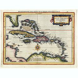
Description des Isles de l'Indie Occidentale.
Map of the Caribbean from the rare Cloppenburg edition slightly larger format and more scarce edition of the Mercator/Hondius "Atlas Minor". Engraved by Pieter ...
Place & Date: Amsterdam, 1630
Selling price: $255
Sold in 2019
Cuba Insula / Hispaniola insula, insets: Havanna portus, celeberrimus totius indiae Occidentalis; Insula Iamaica; Ins. S. Ioannis; Ins. Margareta Cum Confinijis.
A most decorative map of the main Carabean islands from the Mercator / Hondius Atlas. Embellished with seven strapwork cartouches. Ref.: Koeman, Atlantes Neerlandici,...
Place & Date: Amsterdam, c. 1630
Selling price: $420
Sold in 2022
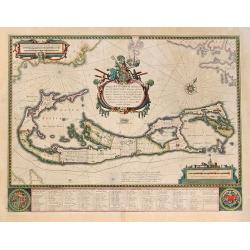
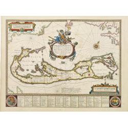
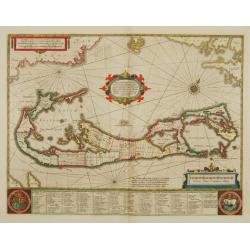
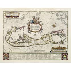
Mappa Aestivarum Insularum, Alias Barmudas. . .
Map is based on the survey by John Norwood of the Bermuda Company in 1618 and it shows the division into the original eight tribes and shows the various landowners, with ...
Place & Date: Amsterdam, 1631
Selling price: $1100
Sold in 2011
![[The English are attacked on St. Lucia.]](/uploads/cache/40366-250x250.jpg)
[The English are attacked on St. Lucia.]
During Oliver Leagh’s voyage to Guiana in 1605, Captain St. John went ashore with a number of the crew. There they built a settlement by the sea and for some weeks trad...
Place & Date: Frankfurt, M.Merian, 1633
Selling price: $95
Sold in 2017
![[Sir Francis Drake attacks the town of Santa Domingo.]](/uploads/cache/40367-250x250.jpg)
[Sir Francis Drake attacks the town of Santa Domingo.]
The town of Santo Domingo on the island of Hispaniola was once the capital of Spanish America but in 1586, when Drake arrived, it had deteriorated somewhat in stature. Be...
Place & Date: Frankfurt, M.Merian, 1633
Selling price: $100
Sold in 2017
![[Vespucci lands on the Island of Giants.]](/uploads/cache/40474-250x250.jpg)
[Vespucci lands on the Island of Giants.]
In 1499-1500, when Antonio de Ojeda and his crew, including Vespucci, landed on an island known today as Curaçao, they saw giant footprints in the sand. These they follo...
Place & Date: Frankfurt, M.Merian, 1633
Selling price: $50
Sold in 2017
![[Sir W. Ralegh in Trinidad] / [The origin of the legend of El Dorado].](/uploads/cache/41097-250x250.jpg)
[Sir W. Ralegh in Trinidad] / [The origin of the legend of El Dorado].
Two engravings. [553] .When Ralegh arrived with his ships at Port-of-Spain in Trinidad, he was courteous and friendly to the local Spanish people who had already colonise...
Place & Date: Frankfurt, M.Merian, 1633
Selling price: $75
Sold in 2018
![[Black slaves work the sugar plantations].](/uploads/cache/41111-250x250.jpg)
[Black slaves work the sugar plantations].
After the veins of precious ore became depleted on Hispaniola, the Spanish set the Black slaves to work on the sugar plantations. This soon became a highly profitable ven...
Place & Date: Frankfurt, M.Merian, 1633
Selling price: $100
Sold in 2019
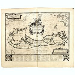
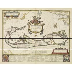
Mappa Aestivarum Insularum alias Barmudas.
Blaeu based his work on John Speed's remarkably accurate map of 1626-1627. It shows the island divided into eight tribes and lots, and below the map itself appear the nam...
Place & Date: Amsterdam, 1634
Selling price: $1500
Sold in 2015
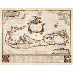
Mappa Aestivarum Insularum alias Barmudas.
Blaeu based his work on John Speed's remarkably accurate map of 1626-1627. It shows the island divided into tribes and lots, and below the map itself appear the names of ...
Place & Date: Amsterdam 1635
Selling price: $2525
Sold
Mappa Aestivarum Insularum alias Barmudas.
Blaeu based his work on John Speed's remarkably accurate map of 1626-1627. It shows the island divided into tribes and lots, and below the map itself appear the names of ...
Place & Date: Amsterdam 1635
Selling price: $1951
Sold
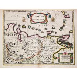
Venezuela, cum parte Australi Novae Andalusiae.
Venezuela, cum parte Australi Novae Andalusiae. A very fine example of Willem Blaeu's map of Venezuela and Columbia, embellished with two cartouches, two compass-roses...
Place & Date: Amsterdam, c. 1635
Selling price: $180
Sold in 2023
![[Lot of 11 maps / views of Central America] Hispaniae Novae Nova Descriptio.](/uploads/cache/18314-250x250.jpg)
[Lot of 11 maps / views of Central America] Hispaniae Novae Nova Descriptio.
A rare pocket size map of Mexico. Johannes Cloppenburg published between 1630 and 1636 his edition of the Mercator-Hondius Atlas Minor. For these editions new plates of a...
Place & Date: Amsterdam, 1635
![[lot of 8 maps/ prints of the Caribbean] Cuba Insula, inset: Havanna portus; Hispanolia Insula; Insula Iamaica; Ins. S. Ioannis; I.s. Margareta.](/uploads/cache/20279-(4)-250x250.jpg)
[lot of 8 maps/ prints of the Caribbean] Cuba Insula, inset: Havanna portus; Hispanolia Insula; Insula Iamaica; Ins. S. Ioannis; I.s. Margareta.
Re-issue of Gerard Mercator's small atlasA lot of 8 maps and prints of the Caribbean.
Place & Date: Amsterdam, 1630-1636
Selling price: $120
Sold in 2022
Mappa Aestivarum Insularum alias Barmudas.
Blaeu based his work on John Speed's remarkably accurate map of 1626-1627. It shows the island divided into tribes and lots, and below the map itself appear the names of ...
Place & Date: Amsterdam, 1638
Selling price: $1800
Sold in 2015
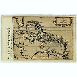
The Ylandes of the West Indies.
Rare map of the West Indies or Caribbean islands from Florida to the northern part of South America. Cartographic elements include degrees of latitude, compass rose, sea ...
Place & Date: London, 1635-1639
Selling price: $400
Sold in 2019
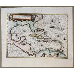
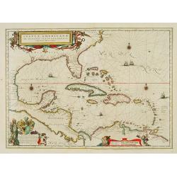
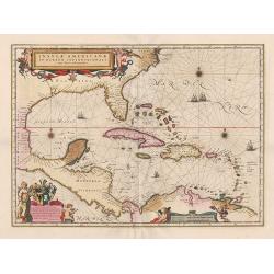
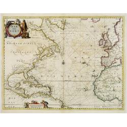
Insulae Americanae in Oceano Septentrionali, cum Terris Adiacentibus.
Early map of the West Indies. Janssonius' edition of Hessel Gerritsz' important map of 1631 made after his voyage to South America and the West Indies during 1628.From Ja...
Place & Date: Amsterdam, 1639
Selling price: $600
Sold in 2020
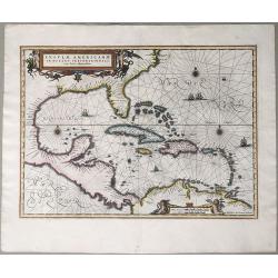
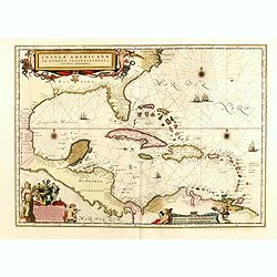
Insulae Americanae in Oceano Septentrionali, cum Terris Adiacentibus.
An early map of the West Indies. Janssonius' edition of Hessel Gerritsz' important map of 1631 made after his voyage to South America and the West Indies during 1628. Fro...
Place & Date: Amsterdam, 1639
Selling price: $650
Sold in 2020
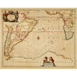
Mar di Aethiopia.
This from Johannes Janssonius' sea-atlas 'De Water-Weereld' covers the area between the Cape of Good Hope and the most southern tip of South America. Giving many place n...
Place & Date: Amsterdam, 1640
Selling price: $600
Sold in 2021
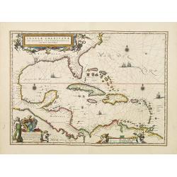
Insulae Americanae in Oceanus Septentrionali cum Terris..
General map of the West Indies extending from Virginia to the mouth of the Orinoco, and destined to be copied in various shapes by many other publishers.Title cartouche t...
Place & Date: Amsterdam 1640
Selling price: $1320
Sold
Insulae Americanae in Oceanus Septentrionali cum Terris..
General map of the West Indies extending from Virginia to the mouth of the Orinoco, and destined to be copied in various shapes by many other publishers.Title cartouche t...
Place & Date: Amsterdam 1642
Selling price: $750
Sold
Insulae Americanae in Oceanus Septentrionali cum Terris..
General map of the West Indies extending from Virginia to the mouth of the Orinoco, and destined to be copied in various shapes by many other publishers.Title cartouche t...
Place & Date: Amsterdam, 1642
Selling price: $950
Sold
Insulae Americanae in oceano septentrionali.
Showing the Gulf of Mexico and the West Indian Islands, and the adjacent North and South American coastlines. The map is based on the map by Gerritsz., except for the add...
Place & Date: Amsterdam, 1639-1644
Selling price: $500
Sold in 2014
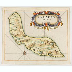
Curacao Eylandt.
One of the earliest separate maps of Curaçao. The map has nice topographical detail and features an ornate title cartouche. Published in de Laet's account of the history...
Place & Date: Amsterdam, 1644
Insulae Americanae in Oceanus Septentrionali cum Terris..
General map of the West Indies extending from Virginia to the mouth of the Orinoco, and destined to be copied in various shapes by many other publishers. Title cartouche ...
Place & Date: Amsterdam 1647
Selling price: $1026
Sold
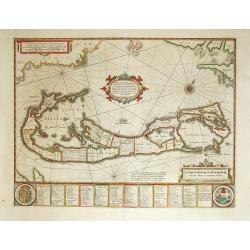
Mappa Aestivarum Insularum, alias Barmudas Dictarum.
A striking map based on the famous survey by Richard Norwood of the Bermuda Company, also known as the Somers Isles Company in 1618. The map shows the division into the o...
Place & Date: Amsterdam, ca.1647
Selling price: $650
Sold in 2014
Insulae Americanae in Oceanus Septentrionali, ...
General map of the West Indies extending from Virginia to the mouth of the Orinoco, and destined to be copied in various shapes by many other publishers.
Place & Date: Amsterdam, 1647
Selling price: $1500
Sold in 2014
Insulae Americanae in Oceanus Septentrionali cum Terris..
General map of the West Indies extending from Virginia to the mouth of the Orinoco, and destined to be copied in various shapes by many other publishers.Title cartouche t...
Place & Date: Amsterdam, 1647
Selling price: $1300
Sold in 2015
Insula S.Iuan de Puertorico caribes vel Canibasun insulae.
Interesting map of the Lesser Antilles, from Porto Rico as far as Trinidad & Tobago and the South American coast. North is orientated to the left of the page.With a s...
Place & Date: Amsterdam 1650
Selling price: $950
Sold

Afbeeldinge in Wat Manier de Silver Vloot Vanden Generael Pieter Pietersen Heyn Veroovert is Anno 1628.
Decorative view showing the Dutch capture of the Spanish silver fleet in the Bay of Matanzas (Cuba) in 1628. With the portrait of Admiral Hein, who captured over eleven m...
Place & Date: Amsterdam, c1650
Selling price: $160
Sold in 2015
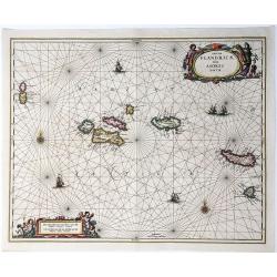
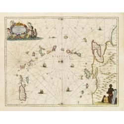
Insulae Flandricae, olim Asores dictae.
A scarce colored sea chart of part of the Atlantic Ocean: the Azores islands ((Faial, Pico, Graciosa, Terceira, Sao Jorge, Formigas, São Miguel), published by Johannes J...
Place & Date: Amsterda, 1650
Selling price: $376
Sold in 2020
Mappa Aestivarum Insularum, alias Barmudas..
This magnificent map is based on the famous survey by John Norwood of the Bermuda Company in 1618. The map shows the division into the original Tribes and shows the vario...
Place & Date: Amsterdam 1646-1657
Selling price: $1800
Sold
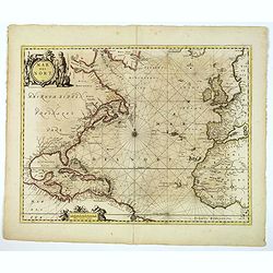
Mar del Nort.
This chart from Johannes Janssonius' sea-atlas 'De Water-Weereld'. The decorative title cartouche shows a native American (as interpreted in Europe!) and various species ...
Place & Date: Amsterdam, 1657
Selling price: $1750
Sold in 2008
Mar del Nort.
This lovely sea chart is from the Johannes Janssonius' sea-atlas De Water-Weereld. The decorative title cartouche shows a native American (as interpreted by those in Euro...
Place & Date: Amsterdam, 1657
Selling price: $700
Sold in 2020
Mappa Aestivarum Insularum alias Barmudas.
Blaeu based his work on John Speed's remarkably accurate map of 1626-1627. It shows the island divided into tribes and lots, and below the map itself appear the names of ...
Place & Date: Amsterdam, 1658
Selling price: $2600
Sold in 2008