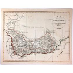
Browse Listings in Africa > Southern Africa > Southern Africa
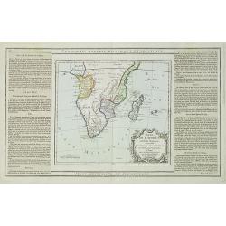
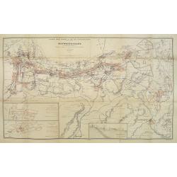
Partie de L'Afrique..
Map showing Southern part of Africa. Left and right box with geographical information for each part country on the continent.Prepared by Louis Brion de la Tour and publis...
Date: Paris 1790
Selling price: ????
Please login to see price!
Sold in 2009
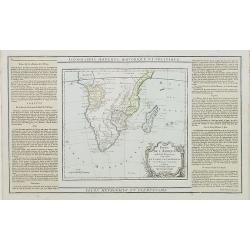
Partie de L'Afrique.. Le Congo, La Cafrerie &c.
Map showing the southern part of Africa with decorative rococo-style cartouche.Left and right box with geographical information for each part of the area. Printed on 2 pa...
Date: Paris, 1790
Selling price: ????
Please login to see price!
Sold in 2023
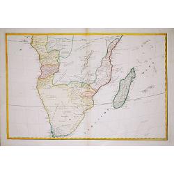
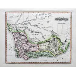
(Map of South Africa)
A large map of South Africa, engraved by Hieronymus Benedicti. Not in Norwich.
Date: Vienna, c. 1790
Selling price: ????
Please login to see price!
Sold in 2021
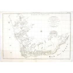
Carte de la Partie Méridionale de l'Afrique, pour servir d'intelligence aux deux voyages de Le Vaillant.
This map depict François Le Vaillant's (1753-1824) two journeys into the interior of Africa, during the years 1783, 1784 and 1785. The route through Namaqualand and alon...
Date: H. J. Jansen et Comp., Paris, 1795
Selling price: ????
Please login to see price!
Sold in 2013
Charte der Sudspize von Africa oder des Hottentotten und Caplands.
A copper engraved map, published in 1811 in Prague. A rare Prague Issue of John Barrow's Map, originally published in 1802 for "An Account of Travels Into the Interi...
Date: Prague, 1811
Selling price: ????
Please login to see price!
Sold in 2016
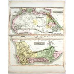
South Africa.
A nicely engraved map with fine hand-coloring. Excellent detail with numerous place names. It also Includes several wells, missionary villages, and short notes.
Date: London, 1813
Selling price: ????
Please login to see price!
Sold in 2017
North Africa & South Africa.
Large hand-colored map of North & South Africa (two maps on one sheet). The interesting map include details of the locations of historic events, cave paintings and ca...
Date: Edinburgh, 1817
Selling price: ????
Please login to see price!
Sold in 2017
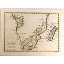
L'Africa Meridionale.
A fine map of southern Africa and Madagascar, by Borghi, from his atlas "Atlante Geograpfico". Bartolomeo Borghi (1750-1821) was an Italian cartographer, engrav...
Date: Florence, 1818
Selling price: ????
Please login to see price!
Sold in 2017
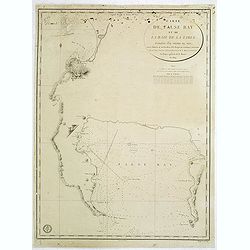
Carte de False Bay et de la Baie de la Table. . .
Very large and detailed of the South African coast from Robben Island to Cape of Good Hope, False Bay and False Cape.Upper right corner the title : CARTE DE FALSE BAY ET...
Date: Paris, Dépôt de la Marine, c.1824
Selling price: ????
Please login to see price!
Sold in 2014
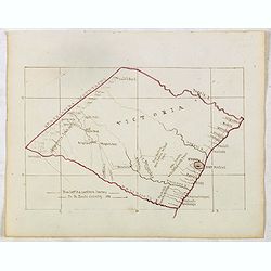
VICTORIA . . .
Finely executed pend drawing in brown ink with coast line in red color. Scale is in English miles. Underneath the title an explanation. In lower left corner "From Ca...
Date: ca. 1836
Selling price: ????
Please login to see price!
Sold in 2015
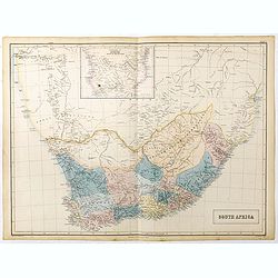
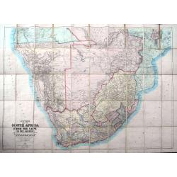
South Africa.
A large map of South Africa with considerable detail, it includes modern day Botswana, Namibia and Mozambique. Inset map at upper centerfold of 'Continuation of Africa so...
Date: Edinburgh, 1856
Selling price: ????
Please login to see price!
Sold in 2023
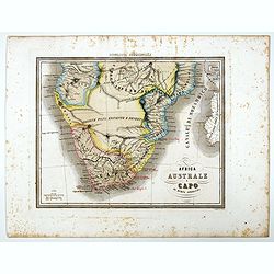
Africa Australe E Capo di buona Speranza.
Uncommon map of Southern Africa and islands prepared by Francesco Costantino Marmocchi. Above the map "Geografia Commerciale". From "Il Globo Atlante di ca...
Date: Genova, Paolo Rivara fu Giacomo, 1858
Selling price: ????
Please login to see price!
Sold in 2021
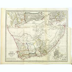
South Africa.
An informative map of South Africa.
Date: London, ca 1860
Selling price: ????
Please login to see price!
Sold in 2018
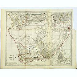
South Africa.
An informative map of South Africa, when it was under British influence. The various districts are highlighted in different outline colors mountains, rivers, coastal town...
Date: London, ca 1860
Selling price: ????
Please login to see price!
Sold in 2022
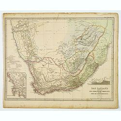
Das Capland nebst den Sud-Afrikanischen Freistaaten und dem gebeit der Kaffern & Hottentotten.
A detailed German map of South Africa, published during the second half of the 19th century. Coastal detail is very good with many place names, bays and points identified...
Date: Gotha, 1863
Selling price: ????
Please login to see price!
Sold in 2021
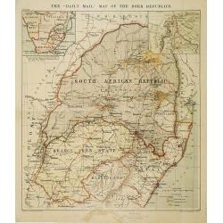
The "Daily Mail" map of the Boer Republics.
Map of the South African Republic, with two inset maps of South Africa and Natal. In lower right keys Railways, roads and British and Portuguese processions and goldfield...
Date: London, Liverpool, ca.1884
Selling price: ????
Please login to see price!
Sold in 2009
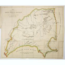
Map Showing The Boundaries Of The South African Republic As Defined By Article I Of The Convention Of London Dated February 27Th 1884
Frederick Dangerfield map of the South African Republic (1884). Map showing the Boundaries of the South African Republic as defined by Article I of the Convention of Lond...
Date: London, Houses Of Parliament ,1884
Selling price: ????
Please login to see price!
Sold in 2017
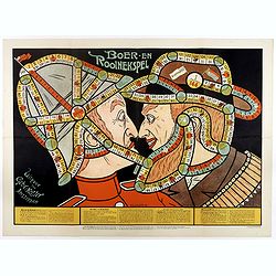
Boer-en Rooinekspel.
Design by E.G.Schlette.
Date: Amsterdam, Koster, ca. 1890
Selling price: ????
Please login to see price!
Sold in 2017
Juta's Map of South Africa from the Cape to the Zambesi...
A large and detailed folding-map of Southern Africa, published by Juta in Cape Town and Standford in London. With regions of the time such as Gaza Land, Orange Free State...
Date: Cape Town (London), 1891
Selling price: ????
Please login to see price!
Sold in 2019
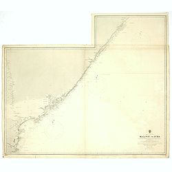
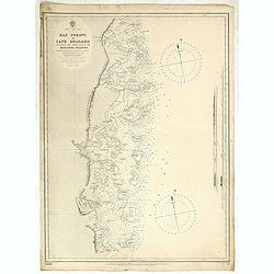
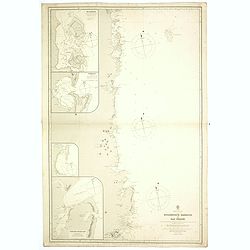
Africa east coast Malindi to Juba Surveyed by Captain ... W. F. W. Owen,1824-25... Surveying ship,
A fine Hydrographic Office chart no. 848 (2245), showing the coast from Malindi to Juba (Kenya). Engraved by Davies & Company. London : Published at the Admiralty 14t...
Date: London, 1877 / 1892
Selling price: ????
Please login to see price!
Sold in 2019
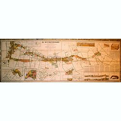
Carte Du District Aurifere Du Witwatersrand Transvaal (Afrique du Sud) Par S. Goldmann d'apres le Cadastre officiel du Gouvernement
VERY RARE OCLC lists one copy at the Bibl. Interuniversitaire Scientifique Jussieu (Paris) and one copy on the trade.Mineralogical survey dating from the early years of t...
Date: (Johannesburg, Decembre 1894 / Paris, 1895
Selling price: ????
Please login to see price!
Sold in 2019
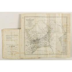
Les Mines d'Or de l'Afrique du Sud. Deuxieme edition considerablement augmentee.
An important work in French on gold and gold mining in South Africa, written shortly following the discovery of gold in the Witwatersrand in 1886, a profound transition f...
Date: Paris, Lemaire & Dupont, 1895
Selling price: ????
Please login to see price!
Sold in 2018
![[Title in Ottoman Turkish: SOUTHERN AFRICA].](/uploads/cache/44732-250x250.jpg)
[Title in Ottoman Turkish: SOUTHERN AFRICA].
A fine Ottoman map of Southern Africa from Ali Şeref Paşa’s rare "Yeñi coġrafya aṭlası", published by the press of Matbaa-i Amire, the successor of İb...
Date: Beyazit, Istanbul: Matbaa-i Amire 1311 or 1895
Selling price: ????
Please login to see price!
Sold in 2026
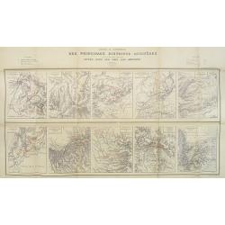
Carte d'Ensemble des Principaux Districts Aurifères (autre que le district aurifère de Witwatersrand) situés dans les pays Sud africains.
Ten inset maps of the main auriferous districts located in various South African countries. A key in upper left and right hand corner. The places with gold mines are indi...
Date: Paris, Monroqo, 1896
Selling price: ????
Please login to see price!
Sold in 2010
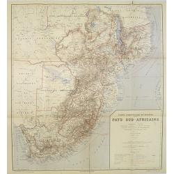
Carte Commerciale et Minière Pays Sud-Africains.
General trade and gold mine map of South Africa.In upper right corner "Carte Commerciale et Minière des Pays Sud-Africains No. 1".Prepared by F. Bianconi. With...
Date: Paris, Monroqo, 1896
Selling price: ????
Please login to see price!
Sold in 2010
Carte des Mines d'Or en exploitation dans le district de Witwatersrand (Transvaal) . . .
Gold mine map situated in the Witwatersrand district with 2 inset maps of New-Primrose and Buffelsdoorn Estate. Also a transverse section of a gold mining extraction mill...
Date: Paris, Monroqo, 1896
Selling price: ????
Please login to see price!
Sold in 2018
![[Map of South Africa]](/uploads/cache/33440-250x250.jpg)
[Map of South Africa]
Lithographic map of South Africa. With label of map seller E. Andriveau-Goujon, Rue le Bac, Paris.
Date: Paris, 1897
Selling price: ????
Please login to see price!
Sold in 2013
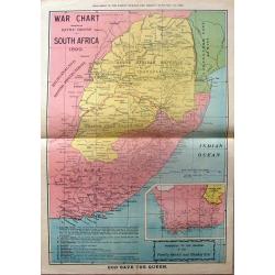
War Chart Showing the Battle Ground in South Africa, 1899.
Fine large map showing the battleground of the South African wars. It has an insert of Cape Colony & the Orange Free State. It was a supplement in "THE FAMILY HE...
Date: South Africa, 1899
Selling price: ????
Please login to see price!
Sold in 2015
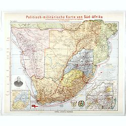
Politisch-militarische Karte von Sud-Afrika zur Veranschaulichung der Kampfe zwischen Buren und Englandern bis zur Gegenward (Large inset map of Goldfelder in Transvaal)
Finely executed map illustrating the progress of the war between the English and the Boers, published by Justus Perhes in 1899.The map includes a tremendous amount of top...
Date: Gotha, 1899
Selling price: ????
Please login to see price!
Sold in 2016
Stanford's Map of British South Africa.
A detailed folding map of South Africa in original red covers. Revised to May 1st, 1899. Stanford's map depicts the most up-to-date mapping of the region at the turn of t...
Date: London, 1899
Selling price: ????
Please login to see price!
Sold in 2018
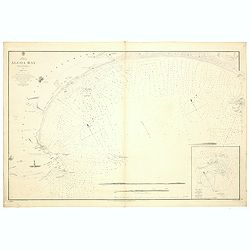
Africa south east Algoa Bay by Lieut Joseph Dayman RN assisted by Lieut HG Simpson RN 1855.
A fine Hydrographic Office chart no. 642 (2191), showing the coast of Algoa Bay with Port Elisabeth and Cape Recife. With three coastal profiles, a lighthouse and one ins...
Date: London, 1856 / 1899
Selling price: ????
Please login to see price!
Sold in 2019
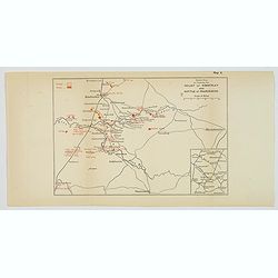
![Battle of Magersfontein. [Situation about Noon].](/uploads/cache/45357-250x250.jpg)
Battle of Magersfontein. [Situation about Noon].
[Map no.7] The Battle of Magersfontein was fought on 11 December 1899, at Magersfontein near Kimberley, South Africa, on the borders of the Cape Colony and the independen...
Date: Edinburgh / London, 1899
Selling price: ????
Please login to see price!
Sold in 2021
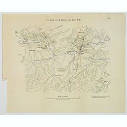
Country round Cloenso and Spion Kop.
[Map no.4] The Battle of Colenso was the third and final battle fought during the Black Week of the Second Boer War. It was fought between British and Boer forces from th...
Date: Edinburgh / London, 1899
Selling price: ????
Please login to see price!
Sold in 2021
![Action at Elandslaagte [Situation about 5pm].](/uploads/cache/45360-250x250.jpg)
Action at Elandslaagte [Situation about 5pm].
[Map no.3] The Battle of Elandslaagte was a battle of the Second Boer War, and one of the few clear-cut tactical victories won by the British during the conflict. However...
Date: Edinburgh / London, 1899
Selling price: ????
Please login to see price!
Sold in 2021
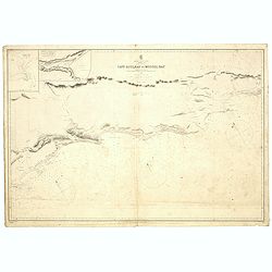
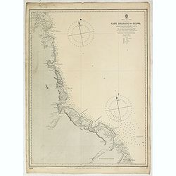
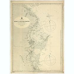
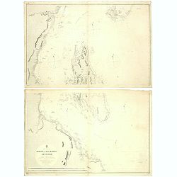
Africa south coast sheet II Cape Colony Cape Agulhas to Mossel Bay compiled from the surveys of Lieutenant J Dayman 1867.
A fine Hydrographic Office chart no. 2083 (2185), showing Cape Agulhas to Mossel Bay. Engraved by E. Standford. London : Published at the Admiralty 16th Sept.r 1867 under...
Date: London, 1858-1860/1900
Selling price: ????
Please login to see price!
Sold in 2019
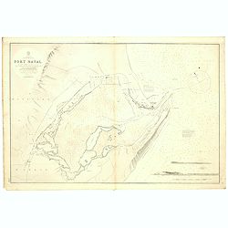
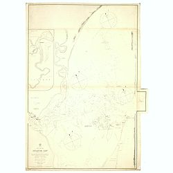
Africa. South East Coast. Port Natal. By lieutenants J. Dayman & H.G. Simpson, R.N., 1854. Additions by Navigating Lieutenant W.E. Archdeacon, R.N. 1872, and by Sir John Coode, C.E., 1877.
A fine Hydrographic Office chart no. 643 (2199), showing Durban formerly Port Natal. Engraved by J. & C. Walker. London : Published at the Admiralty 23rd August 1856 ...
Date: London, 1854 / 1900
Selling price: ????
Please login to see price!
Sold in 2019
![Africa east coast Tugela river to Delagoa Bay surveyed by Captain Pelham Aldrich assisted by [...] HMS Sylvia 1884](/uploads/cache/43733-250x250.jpg)
Africa east coast Tugela river to Delagoa Bay surveyed by Captain Pelham Aldrich assisted by [...] HMS Sylvia 1884
A fine Hydrographic Office chart no. 2089 (2204) showing the Tugela River to Maputo Bay. Engraved by Davies & Comp. London : Published at the Admiralty 15 Feb.y 1836 ...
Date: London, 1884 / 1900
Selling price: ????
Please login to see price!
Sold in 2019
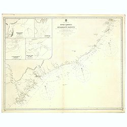
Africa south east coast Sheet VII. Umtavuna River to Tugela River With two coastal profiles Surveyed by Navigating Lieutenant W.e. Archdeacon, R. N. Assisted by Mr. F. Purdy, Civilian, 1872...
A fine Hydrographic Office chart no. 2088 (2198), showing the coast with shepstone, Scottsburg and Durban formerly Port Natal. Engraved by Edw.d Weller. London : Publishe...
Date: London, 1854 / 1900
Selling price: ????
Please login to see price!
Sold in 2019
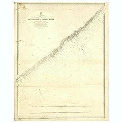
Africa south coast sheet V Cape Colony Waterloo Bay to Bashee River surveyed by Navigating Lieutenant WE Archdeacon RN assisted by ... Africa - SW coast Table Bay surveyed by Mr F Skead Master RN assisted by Mr Charles Watermeyer 1858-60
A fine Hydrographic Office chart no. 2086 (2194), showing the coast from Waterloo Bay to Mbhashe River. Engraved by Edw.d Weller. London : Published at the Admiralty 5th ...
Date: London, 1872/ 1900
Selling price: ????
Please login to see price!
Sold in 2019
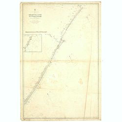
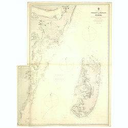
Africa east coast River Zambezi to Mozambique Harbour surveys by Captain W. F. W. Owen HMS Leven and Barracouta 1824... With additions and corrections to 1883...
A fine Hydrographic Office chart no. 1810 (2218), showing the coast from Zambesi river to Mozambique Harbour. Engraved by Edw.d Weller. London : Published at the Admiralt...
Date: London, 1883 / 1900
Selling price: ????
Please login to see price!
Sold in 2019
Sheet VIII Africa east coast Cape Delgado to Kilwa surveyed by Lieutenant Commanding FJ Gray RN HMS Nassau 1874-5...
A fine Hydrographic Office chart no. 1808 (2224), showing the coast from Cape Delgado to Kilwa. Engraved by Davies & Company. London : Published at the Admiralty 1st ...
Date: London, 1875 / 1900
Selling price: ????
Please login to see price!
Sold in 2019
Sheet VII Africa east coast Ras Pekawi to Cape Delgado including the north part of the Kerimba islands Surveyed by Lieutenant Commanding, F. J. Gray, R. N., ... 1875...
A fine Hydrographic Office chart no. 658 (2223), showing the coast from Ras Pekawi to Cape Delgado. Engraved by Davies & Company. London : Published at the Admiralty ...
Date: London, 1875 / 1900
Selling price: ????
Please login to see price!
Sold in 2019
Sheet IX Africa east coast Kilwa P.t to Zanzibar Channel Surveyed by Commander W. J. L. Wharton... , F. J. Gray, R. N., ... 1874-77... Magnetic variation in 1900, decreasing about 2' annually.
A fine Hydrographic Office chart no. 662 (2230), showing the coast from Kilwa P.t to Zanzibar Channel. Engraved by Davies & Company. London : Published at the Admiral...
Date: London, 1875 / 1900
Selling price: ????
Please login to see price!
Sold in 2019
Africa east coast Zanzibar to Malindi ... H. M. Surveying ship Stork, 1888-90. Magnetic variation in 1890, decreasing slightly. Africa - SW coast Table Bay surveyed by Mr F Skead Master RN assisted by Mr Charles Watermeyer 1858-60
A fine Hydrographic Office chart no. 664 (2235), showing the coast from Zanzibar to Malindi with Zanzibar and Pemba Islands. Engraved by Davies & Company. London : Pu...
Date: London, 1890 / 1900
Selling price: ????
Please login to see price!
Sold in 2019
Africa east coast, Port Mombasa with Ports Kilindini, Reitz and Tudor... H. M. Surveying ship Stork, 1888. Africa - SW coast Table Bay surveyed by Mr F Skead Master RN assisted by Mr Charles Watermeyer 1858-60
A fine Hydrographic Office chart no. 666 (2243), showing Mombasa Harbour and Island. Engraved by Davies & Company. London : Published at the Admiralty 30th. May, 1890...
Date: London, 1888 / 1900
Selling price: ????
Please login to see price!
Sold in 2019
Africa east coast Mozambique Harbour to Ras Pekawi surveys by Captain WFW Owen HMS Leven and Barracouta 1824... Magnetic variation in 1900, decreasing about 2' annually. . .
A fine Hydrographic Office chart no.1809 with six insets : 1. Ibo Harbour surveyed by Captain W.F.W. Owen RN 1824 circa 1:20,000.2. Pomba Bay [Mwabi or Pemba] surveyed by...
Date: London, 1883 / 1900
Selling price: ????
Please login to see price!
Sold in 2019
Africa east coast Pangani to Ras Kimbiji including the approaches to Zanzibar... Surveyed by commander W. J. L. Wharton. . .
A fine Hydrographic Office chart no. 640a and 640b of the coast with Dar es Salaam and the Island of Zanzibar. Engraved by Edw.d Weller. London : Published at the Admiral...
Date: London, 1873-74 / 1900
Selling price: ????
Please login to see price!
Sold in 2019
Africa east coast Chale Point to Pangani including the island of Pemba surveyed by Commander WJL Wharton HM surveying ship Fawn . . .
A fine Hydrographic Office chart no. 1390 of Pemba channel with one inset plan. Irregular shape. Inset: Wasin Channel by Commander T F Pullen. Engraved by Davies and Comp...
Date: London, 1899 / 1900
Selling price: ????
Please login to see price!
Sold in 2019
Africa east coast Delagoa Bay (Lorenzo Marques) surveyed by Captain WFW Owen and the officers of HMS Leven and Barracouta 1822-5. . .
A fine Hydrographic Office chart no.644 (2205), showing Africa's east coast with Delagoa Bay (Lorenzo Marques) surveyed by Captain WFW Owen and the officers of HMS Leven ...
Date: London, 1885 / 1900
Selling price: ????
Please login to see price!
Sold in 2019
![Battle of Paardeberg. [Situation about 5pm].](/uploads/cache/45359-250x250.jpg)
Battle of Paardeberg. [Situation about 5pm].
[Map no.8a] The Battle of Paardeberg or Perdeberg ("Horse Mountain") was a major battle during the Second Anglo-Boer War. It was fought near Paardeberg Drift on...
Date: Edinburgh / London, ca 1900
Selling price: ????
Please login to see price!
Sold in 2021
Sketch Map to illustrate the Relief of Kimberley and Battle of Paardeberg.
[Map no.8] The Siege of Kimberley took place during the Second Boer War at Kimberley, Cape Colony (present-day South Africa) when Boer forces from the Orange Free State a...
Date: Edinburgh / London, ca 1900
Selling price: ????
Please login to see price!
Sold in 2021
![Actions at Vaalkranz 5th-7th February 1900 [Situation at Noon 6th February].](/uploads/cache/45362-250x250.jpg)
Actions at Vaalkranz 5th-7th February 1900 [Situation at Noon 6th February].
[Map no.7] The Battle of Vaal Krantz (5 February to 7 February 1900) was the third failed attempt by General Redvers Buller's British army to fight its way past Louis Bot...
Date: Edinburgh / London, 1900
Selling price: ????
Please login to see price!
Sold in 2021
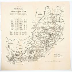
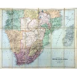
Map of the Transvaal, Orange Free State and British South-Africa.
A large scale, easy to read map of British South Africa (Cape Colony) and the Orange Free State and Transvaal, and north to Rhodesia (Zimbabwe). The map offers an extensi...
Date: Edinburgh, London, ca 1900
Selling price: ????
Please login to see price!
Sold in 2021
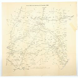
General Map for the Operations till November, 1900
[Map no.1] A large folding map showing the field of all British operations up until November 1900. It stretches from Kimberley (OFS) in the SW to Lyndenburg in the NW (Tr...
Date: Edinburgh, London, ca 1900
Selling price: ????
Please login to see price!
Sold in 2021
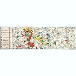
Sketch Map of the Far Eastern Rand from Johannesburg to Ermelo.
An extremely rare map showing mining concessions on the Eastern Part of the Witwatersrand Vein, the most important gold region in the world, published shortly after the S...
Date: Bern, Geographischer Karten-Verlag Kümmerly & Frey, ca. 1905
Selling price: ????
Please login to see price!
Sold in 2017
![[Africa - General continental map with Ottoman script]](/uploads/cache/44736-250x250.jpg)
[Africa - General continental map with Ottoman script]
Post card size map in Ottoman script showing Southern Africa from Mehmet Eşref’s ‘Küçük Atlas’, a rare portfolio of loose-leaf maps with text in Ottoman Turkis...
Date: Istanbul, Şirket-i Mürettibiye ve Karacoğlu Matbaası 1325 or 1909
Selling price: ????
Please login to see price!
Sold in 2022
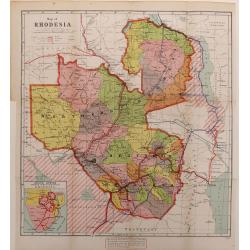
Map of Rhodesia.
A color-printed, wood engraved map of Rhodesia (now Zimbabwe), as administered by the British South Africa Company, which lasted from 1889 to 1924, when it became a Briti...
Date: London, 1923
Selling price: ????
Please login to see price!
Sold in 2016
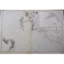
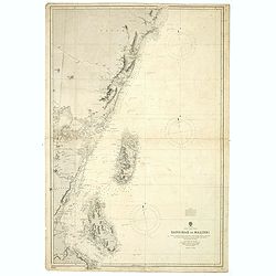
Table Bay to Cape Agulhas.
A large scale Admiralty sea-chart of Cape Town, extending until Struis Bay. With excellent detail of the coasts, including depth soundings. With two insets of Point Dange...
Date: London, 1973
Selling price: ????
Please login to see price!
Sold in 2018
