Browse Listings
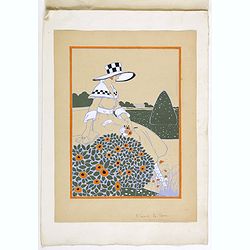
(Art déco gouache)
Outstanding "art deco" gouache (unsigned) from the workshop of "Robert Pichon. Ateliers de Dessin et Lithographie – 10, rue Rochechouart – Paris. The g...
Place & Date: Paris, ca. 1930

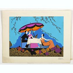
(Art déco gouache)
Outstanding "art deco" gouache (unsigned) from the workshop of "Robert Pichon. Ateliers de Dessin et Lithographie – 10, rue Rochechouart – Paris. The g...
Place & Date: Paris, ca. 1930
(Art-déco gouache)
Outstanding "art deco" gouache (unsigned) from the workshop of "Robert Pichon. Ateliers de Dessin et Lithographie – 10, rue Rochechouart – Paris. The g...
Place & Date: Paris, ca. 1930

(Art-déco gouache)
Outstanding "art deco" gouache (unsigned) from the workshop of "Robert Pichon. Ateliers de Dessin et Lithographie – 10, rue Rochechouart – Paris. The g...
Place & Date: Paris, ca. 1930

La Pieuvre Germanique.
Scarce lithographed plate not dated, by Eugène Danzanvilliers, printed by Grandremy in Paris. The plate listed by Adhemar is dated 1874. Eugène Danzanvilliers was a dra...
Place & Date: Paris, 28 Quai de la Rapée, c.1874

Tweevoudigh onderwiis van de Hemelsche en Aerdsche Globen; Het een Na de meyning van Ptolemeus met een vasten Aerdkloot...
Tweevoudigh onderwiis van de Hemelsche en Aerdsche Globen; Het een Na de meyning van Ptolemeus met een vasten Aerdkloot; Het ander Na de Natuerlijcke stelling van N. Cope...
Place & Date: Amsterdam, 1655

Atlas Universel de Géographie. Sixième partie - Océanique.
Volume 6 including detailed maps of Australia, New Zealand, Hawaii, Pacific islands, Indonesia and 3 maps of the Philippines. With title page and one general map.Supporte...
Place & Date: Brussels 1827

Nieuwe en Nette Afteekening van het Eyland Corsica en het Eyland Elba vertoonende alle desselfs Havenen, Steeden en Rivieren . . .
Highly decorative large sea chart of Corsica, Sardinia and Elba, including multiple sailing ships, compass roses, cartouche, coat of arms, rhumb lines, topographical deta...
Place & Date: Amsterdam, ca. 1710

Asiae Minoris nova descriptio. Geographische Beschryvinge aller Landen... ende sendbrieuen der Apostele...
Extremely rare map from a Dutch bible, published by Dancker Danckerts. This map was included in a Dutch bible including several maps signed by C.Danckerts and one dated 1...
Place & Date: Amsterdam, 1643

Calendrier de la cour, tiré des éphémérides, pour l'Année bissextile.. / Notebook bearing silver plates with the VOC monogram.
A personal gift, only made for the trustees of the V.O.C. The silver plate was probably made by Drick van Hengel and Company because an entry in the diary of mintmaster J...
Place & Date: Paris, 1787

Nova et Accuratissima Totius Terrarum Orbis Tabula.
Since its appearance as an Appendix in 1630, the atlas launched by Willem Blaeu and continued by his son Joan had expanded greatly. But despite many new regional maps the...
Place & Date: Amsterdam, 1662
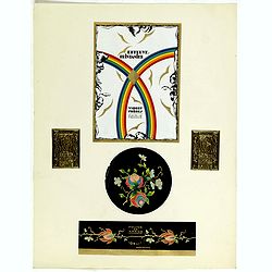
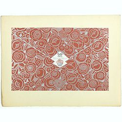
Five Art déco labels.
5 Lithographed perfume labels laid on original cardboard sheet. A striking example of commercial artworks produced by the artist and graphic designer Robert Pichon and hi...
Place & Date: Paris, between 1925 and 1930
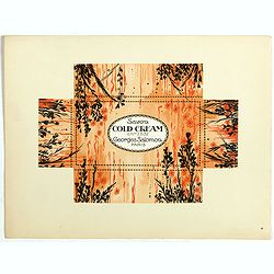
Art déco label for Georges Salomon Paris.
Lithographed perfume label "Savon Cold cream N°1531 - Georges Salomon Paris" laid on original cardboard sheet. A striking example of commercial artworks produc...
Place & Date: Paris, between 1925 and 1930
Art déco label Biette Savon - Tein de fleur.
Lithographed perfume label " Biette Savon - Tein de fleur" laid on original cardboard sheet. A striking example of commercial artworks produced by the artist an...
Place & Date: Paris, between 1925 and 1930
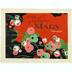
Art déco label for Parfum Mary France.
Lithographed perfume label "Parfum Mary France" laid on original cardboard sheet. A striking example of commercial artworks produced by the artist and graphic d...
Place & Date: Paris, between 1925 and 1930
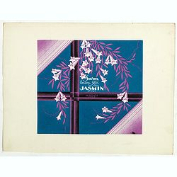
Art déco label for de Neuville, Paris.
Lithographed perfume label " Savon extra fin au jasmin N°1727 " laid on original cardboard sheet. A striking example of commercial artworks produced by the art...
Place & Date: Paris, between 1925 and 1930
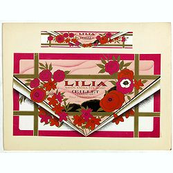
Art déco label Paul Tranoy, Paris.
Lithographed perfume label " Lilia Savon extra fin soap - Œillet (carnation) Paul Tranoy Paris N°725 " laid on original cardboard sheet. A striking example of...
Place & Date: Paris, between 1925 and 1930

A Map of the British Empire in AMERICA with the French, Spanish and Hollandish Settlements Adjacent Thereto. by Henry Popple. / Nouvelle Carte Particuliere de L'Amerique . . .
The four sheet Dutch edition of Popple's monumental map of North America, in mint condition. Encompassing the West Indies, Florida, Louisiana, Texas and Central America.T...
Place & Date: Amsterdam, ca. 1737

Le Théâtre du monde dédié au roi contenant les cartes générales et particulières des royaumes et états qui le composent.
The present example of the Théâtre du monde is the reissue of 1746 by Jean-Baptiste Nolin II. This scarce atlas is illustrated with 123 maps mostly double-page, in orig...
Place & Date: Paris, 1746
![[Il mondo a pezzi - Europa].](/uploads/cache/42849-250x250.jpg)
[Il mondo a pezzi - Europa].
Satirical representation of the division of the world by the main European powers. At the center of the scene a globe on which is written "MONDO Maledeto Interesse ...
Place & Date: Bologna, 1690

Carte d'unne partie de l'Arabie Septentrionale Pour suivre les Voyages de Mr. G.A. Vallin. . .
This is the original hand-drawn map by Victor Adolphe Malte-Brun of "Carte d'unne partie de l'Arabie Septentrionale Pour suivre les Voyages de Mr. G.A. Wallin",...
Place & Date: Paris, November 1855

Vue et description des principales villes de l'Armenie et de la Georgie avec les habillements des femmes du pays, et ceux des prêtres et religieux armeniens. . .Tom: V N° 11 Pag: 28
View and description of the principal Armenian and Georgian cities with illustrations of Armenian women's garments as well as priests' and monks' clothing. The views are ...
Place & Date: Amsterdam, ca 1720

Rare collection of costume plates.
Rare collection of costume plates published in Augsburg by the famous publishers Martin Engelbrecht, Ioh. Georg Hertel and the Jeremias Wolff Heirs.Composition :2 plates ...
Place & Date: Augsburg, ca. 1730
![[ Hong Kong / Canton ] Nieuwe Pas=Caart strekkende van Pta Cataon tot Pta. Lamtoan, langs de kusten van Cochinchina, Tonquin, Quangsi en Quantung [?] van Macao.](/uploads/cache/24951-250x250.jpg)
[ Hong Kong / Canton ] Nieuwe Pas=Caart strekkende van Pta Cataon tot Pta. Lamtoan, langs de kusten van Cochinchina, Tonquin, Quangsi en Quantung [?] van Macao.
A finely engraved and detailed chart of Vietnam reaching to Macao and present-day Hong Kong..Very rare: only included in the 6th volume (so-called secret atlas) of Van Ke...
Place & Date: Amsterdam, 1753

Tabula nova Poloniae et Silesiae.
Second state, dated 1630 underneath the title. A finely engraved carte á figures with cartouche representing in the four corners of the map : Kings ( on the left side Si...
Place & Date: Amsterdam, 1630
![[West Central London from Booth's Poverty Map of London]](/uploads/cache/40267-250x250.jpg)
[West Central London from Booth's Poverty Map of London]
A map of West Central London, one section (of twenty) of an extended version of the incredibly influential Poverty Map, originally published in Charles Booth's 'Life and ...
Place & Date: London, 1900

Belgii novi, angliae novae, et partis Virginiae . . .
This example is state 3 of the original Janssonius plate, printed after Schenk acquired the plates at public auction in 1694 from the heirs of Jansson van Waesberge. The ...
Place & Date: Amsterdam, 1694

Asia carta di ciasete piu moderna. (Japan)
Rare FIRST STATE of this important map for Korea and Japan map of the Blancus/Moreira type, but adds a huge 'Jesso' filling the top of this old map. The map is of interes...
Place & Date: Florence, 1646-1647
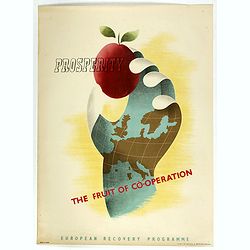
Prosperity - The Fruit of Cooperation.
NATO poster for European Cooperation by Brian E. Dear. On the poster the slogan "Prosperity the fruit of cooperation". The poster is showing a hand holding an a...
Place & Date: Kühn & Zoon Rotterdam, 1950
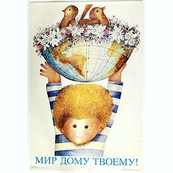
Protect the globe!, 1989.
USSR propaganda poster, with the slogan "protect de globe". A child holding a globe with flowers and birds.
Place & Date: Russia, 1989

COLLECTION OF HONG KONG MAPS, BOOKS & FLYERS. Including CHINA - HONGKONG surveyed by Captn. Sir Edward Belcher, in H.M.S. Sulphur 1841. Corrected to 1901.
A collection of 30 maps, prints, and publications relating to Hong Kong. Including : - BELCHER, E. Sir, An updated version of this most important nautical chart of Hong K...
Place & Date: London, 1841 - 1901
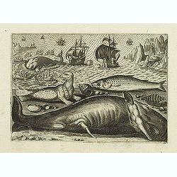
Virulus marinus. Cete (Whale and whaling scene)
Whale and whaling scene, set against a mountainous landscape in the manner of Pieter Brueghel the Elder. Plate number 1. The engraving is copied after Adrian Collaert pla...
Place & Date: Antwerp, after 1598

Typus Frisiae Orientalis à Dullarto
One of the most decorative maps of East Frisia and its important shipping center of Emden and the Watten Islands, from the cartography of Ubbo Emmius, a local cartographe...
Place & Date: Amsterdam, ca. 1624

Karte von den Kusten von Arabien . . .
Manuscript map of Arabia. A close copy of Bellin's map of the Arabian Peninsula. In the lower right margin "Tom A, vol V."A title cartouche in the lower left co...
Place & Date: Germany, ca. 1760

(EUROPE).
A woodcut colored map of northern and central Europe. The first modern map of the area. Second printed map of the North, after the woodcut map published in the 'Ulm' Ptol...
Place & Date: Nuremberg, 1493

Le temple de la Mecque avec une description de tout ce qu'on y voit . . .
Fascinating engraving depicting the Muslim Kaaba at Mecca. Below the main image are two smaller vignette images of people praying. In between the two vignettes is a key (...
Place & Date: Amsterdam, 1728

Universe Europae Maritime Eiusque Navigationis Descriptio. Generale Pascaerte van Europa . . .
This general chart of north-western Europe and the surrounding coastal waters is from the rare pilot-guide De Spiegel der Zeevaerdt , printed by Christopher Plantin in Le...
Place & Date: Leyden, 1584

Driving chart of Hartford and vicinity : 15 miles around.
Road map by Albert A. Hyde & Co. of Hartford and vicinity, with the Connecticut River in the center. Published by Albert A. Hyde & Co., in New York and lithograph...
Place & Date: New York / Philadelphia, 1884

San Diego Bay. (Chart 5107)
Nautical chart of San Diego Bay of 1945. Printed in black, yellow and purple the "Seaward limit defensive sea area". The water area within the indicated limits ...
Place & Date: Washington, 1945

Nader prolongatie van het Octroy voor de Westindische Compagnie voor den tyd van nog dertig jaaren. . .
A proclamation by the Dutch States General, dated 1761, extending the charter of the Dutch West India Company for another thirty years. Like the 1730 proclamation, it has...
Place & Date: Amsterdam, 1761

The Kingdome of China.
A most sought-after map of China. Decorative border vignettes including views of the cities of Quinzay and Macao along the top border with the wheeled wind machines and p...
Place & Date: London, G. Humble, 1627

Nova Totius Terrarum Orbis Geographica ac Hydrographica Tabula.
A beautifully decorative world map taken from the 'English Atlas' by Moses Pitt and Steven Swart, based on an earlier engraved world map by Pieter van den Keere ca. 1630,...
Place & Date: Oxford, 1680

Colossus Monarchic. Statua Danielis
Fantastic double page allegorical map of a colossus figure representing the great world empires as Daniel interpreted in Nebuchadnezzar's dream. The warrior stands stolid...
Place & Date: Augsbourg, 1730

Carte particulière des environs de St Peters-bourg. . . / Plan de la ville faubourg et environs de St Petersbourg. . . / Carte pour l'intelligence de la guerre de Moscovie et de Suede. . .
A scarce and unusual plan of Saint Petersburg shown at a large scale and also, in a separate compartment, shown in its geographical context between the Gulf of Finland an...
Place & Date: Paris, c.1741

Nuevo plano de la ciudad de Buenos Aires y parte del partido de avellaneda . . .
A rare detailed city plan of Buenos Aires prepared in 1912 by Ernesto Escalante. The plan depicts the city from the Partido de Avellaneda and the Villa Riachuelo to the R...
Place & Date: Buenos Aires, 1912

CARTE de la Côte Occidentale de COREE, Plan Croquis de la Rivière HAN-KANG ou de SEOUL, depuis son Embouchure jusqu'à Séoul, dressée en 1866 ...
Uncommon chart of the Han-Kang River from its mouth to Seoul, prepared in 1866 by order of C.A. ROZE, Commander-in-Chief of the French " la Station des Mers de Chine...
Place & Date: Paris, 1868

Tabula nova utriusque Indiae.
This is the fourth and last edition of this map based on Waldseemüller's first "modern" map of Asia. It follows that cartography without change but adds an int...
Place & Date: Vienne, 1541

Tabula Superioris Indiae & Tartariae maioris. (Modern Map of China, Japan, etc.)
Important map extending from Tartary in the north, to "Prov. Bocat" (Cambodia) in the south. "Tebet" is shown prominently, as is "Zinpangri"...
Place & Date: Vienne, 1541
![Hanc Tabulam continens Laetam Pharnambuci.. . [Brazil].](/uploads/cache/16521-250x250.jpg)
Hanc Tabulam continens Laetam Pharnambuci.. . [Brazil].
An extremely rare and decorative map of coast-line of Pernambuco. With one inset: In the upper left corner a map of Brazil, with title in five lines Dutch and five lines ...
Place & Date: Amsterdam, 1630

Chinae, olim Sinarum Regionis, nova descriptio. Auctore Ludovico Georgio.
The first map of China ever to appear in a Western atlas, west to the top. The first state without "las Philiooinas" somewhere in 1587 added to the plate. When ...
Place & Date: Antwerp, 1584

Occidentalis Americae partis.
The most beautifully engraved early map of the Caribbean, including Florida and the Southeast. The map includes representations of Columbus' ships and various notes regar...
Place & Date: Frankfurt, 1594

Americae Sive Novi Orbis, Nova Descriptio.
This is the second copperplate of Ortelius' map showing the western hemisphere, showing the prominent bulge in the South American coastline. An important map because of i...
Place & Date: Antwerp, 1579
![The Coast of New Found Land From Salmon Cove to Cape Bonavista. . . [together with] The Coast of New Found Land from Cape-Raze to Cape St-Francis.](/uploads/cache/40658-250x250.jpg)
The Coast of New Found Land From Salmon Cove to Cape Bonavista. . . [together with] The Coast of New Found Land from Cape-Raze to Cape St-Francis.
Two charts showing the coast of New Found Land from Salmon Cove to Cape Bonavista and from Cape-Raze to Cape St-Francis. With inset chart of Trinity HarborGrierson publis...
Place & Date: Dublin, 1767

The Harbour of Casco Bay and Islands Adjacent Bt Capt. Cyprian Southicke.
The earliest printed chart of Casco Bay, an inlet of the Gulf of Maine on the southern coast of Maine, New England. First issued in 1720 by Mount and Page, it remained in...
Place & Date: Dublin, 1767

Insularum Moluccarum Nova description.
Exquisite map of the famous Spice Islands based on the islands described by Jan Huyghen van Linschoten. This map was the first large-scale map of the region and depicts t...
Place & Date: Amsterdam, 1730

(Totius Americae nova et exacta tabula ex) optimis tum geographorum tum aliorum scriptis collecta et ad hodiernam regnorum principatuum et maiorum partium distinctionem accomodata.
Eastern part of a two-sheet map of America, with attribution to Willem Blaeu. According to Philip Burden, the map was derived from Cornelius Danckert's 1647 map of the sa...
Place & Date: Rome, 1679

Palatinatus Rheni Nova et Accurata Descriptio.
Early state (1630) of Visscher's "carte à figures"- map of the German Rhine River Valley. Inset views of Frankfurt am Main, Mainz, Speyer, Worms and Heidelberg...
Place & Date: Amsterdam, 1630
The Family Atlas Containing Eighty maps Constructed by Eminent Geographers. . .
Un unrecorded later edition of the S.D.U.K. Family atlas, with 80 plus one extra map. Most maps are single sheet but several are double page maps. Printed on heavy paper ...
Place & Date: London Edward Stanford, 1874

World Flight Routes (all in Japanese).
A large very decorative Japanese world map published as sugoroku (a Japanese game which might be compared to backgammon) published as a supplement to the 1930 New Year’...
Place & Date: Osaka, 1930

A-Na-Cam-E-Gish-Ca. A Chippeway Chief.
Half-length portrait of Anacamegishca, bare-chested, wearing a blanket and a peace medal. A-Na-Cam-E-Gish-Ca (1785-1862) - was a Chippeway Indian Chief. The Chippewa is o...
Place & Date: Philadelphia, 1837
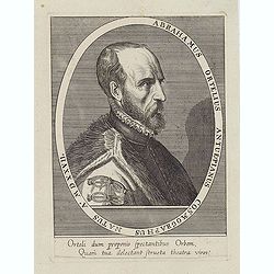
Abrahamus Ortelius Antuerpianus cosmographus natus a. MDXXVII
Portrait of Abraham Ortelius (Abraham Ortel), famous cartographer born in Antwerp and after studying Greek, Latin and mathematics set up a business there with his sister,...
Place & Date: Antwerp, c.1650
Selling price: $225
Sold in 2023

Allerneuester geographisch- und topographischer Schau-Platz von Africa und Ost-Indien. . .
An early issue of this important book by Johann Wolfgang Heydt's describing the Dutch factories, settlements and stations at the hands of the Dutch East India Company in ...
Place & Date: Wilhermsdorf, Tetscher u. Nürnberg, Homanns Erben, 1744

Karte von Europa im Jahre 1870 nach einem französischen Holzschnitte.
Satirical illustration by Paul Hadol showing disposition of power in Europe at the beginning of 1870. Satirical print depicting a map of Europe in which the countries are...
Place & Date: Hamburg, Fuchs, 1914

Hamburgum.
Engraved bird's-eye town-plan of Hamburg, two keys below. Frederick de Wit published after 1694 a town book of European and Asian cities (Theatrum Praecipuarum Totius Eur...
Place & Date: Amsterdam, ca. 1694

Germania.
Second state of this rare "carte à figures"- map of Germany, The Netherlands, Poland and central Europe. Bordered on three sides with portraits and views. In t...
Place & Date: Amsterdam, 1607

Hark ! Hark ! The dogs do bark.
This very rare political caricature map of Europe depicts the continent at the outbreak of World War I, or as it was called at the time the Great War. Designed by Johnson...
Place & Date: London, Johnson Riddle & Co., 1914

Asia secunda pars in forma Pegasi.
UNRECORDED PLATE or STATE. Asia depicted as the flying horse Pegasus. Below the depiction 3 lines of engraved Latin text. Double page copper engraved map from Heinrich B�...
Place & Date: Brunswick, ca. 1635

Asia secunda pars terrae in forma Pegasi.
Asia depicted as the flying horse Pegasus. Thiscartographical curiosity, double page copper engraved map, was published in Heinrich Bünting's “Itinerarium Sacrae Scrip...
Place & Date: Brunswick, 1640

Guyana, Surinam, Amapa.
Very rare Ottoman printed map of Guyana, Suriname and Amapa. With Trinidad, an inset map of the mouth of the Rivers Essequibo, Courantyne, Suriname with Paramaribo.From C...
Place & Date: Üsküdar (Istanbul), 1803

Military map of the countries between Odessa & Perekop with the stations of the Russian forces.
Rare colored linen-backed map showing Russian troop positions and Odessa Batteries. On the inside of the cover a list of "Wyld's list of recent publications : seat o...
Place & Date: London, ca. 1855

Pascarte van Europa Beginnende vande Canael tot aen Spitbergen, en van Ysland tot aen Nova Zemla . . .
An eye-catching chart of northern Europe with a coastline from northern Russia to the Dutch English Channel in the south. Good detail on Iceland. North to the top.In the ...
Place & Date: Amsterdam, after 1666

Carte des Iles Hawaii.
A lovely small map of the complete chain of Pacific islands known today as the Hawaiian islands, from Dumont d'Urville's atlas "Voyage pittoresque autour du Monde.&q...
Place & Date: Paris, 1834

Gustaaf Willem Baron van Imhoff.
Decorative portrait of Gustaaf Willem Baron van Imhoff, who was Governor for the V.O.C. (Dutch East Indian Company) in Indonesia.
Place & Date: Amsterdam, 1745

Americae Pars Magis Cognita. Chorographia nobilis & opulentae Peruanae Provinciae, atque Brasiliae, . . . MDXCII
First state. Although a map of South America it does include much of what is now the southern United States. There are two elaborate, strap-work cartouches with the one a...
Place & Date: Frankfurt, 1592
![Tabula electoratus Brandenburgici, Meckelenburgi, et maximae partis Pomeraniae, ex variis, famosissimisq[ue] auctoribus summo studio concinnata. . .](/uploads/cache/37545-250x250.jpg)
Tabula electoratus Brandenburgici, Meckelenburgi, et maximae partis Pomeraniae, ex variis, famosissimisq[ue] auctoribus summo studio concinnata. . .
Uncommon "carte à figures"- map engraved by the master engraver Abraham Goos and published by Claes Jansz. Visscher (1587-1652). Showing the part of western Po...
Place & Date: Amsterdam, 1630
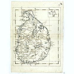
Isola Di Ceylan. (Manuscript map of Sri Lanka)
Manuscript map of Sri Lanka (Ceylon). Inland filled with a good number of place names, mountains.
Place & Date: Italy, ca. 1750

New Jersey entworfen von D.F. Sotzmann. Hamburg bey Carl Ernst Bohn 1796 . . . NO.VIII
Extremely rare map of New Hampshire prepared by Daniel Friedrich Sotzmann for Christopher Ebeling's "Erdbeschreibung von Amerika", a project ended after only te...
Place & Date: Hamburg, Carl Ernst Bohn, 1797

Die Insel Formosa neu abgemessen auf Befehl Kaysers Kamhi.
One of the earliest obtainable printed map of Taiwan or Formosa Island. It was issued around 1726 to illustrate Joseph Stöcklein's [Stoecklein] compellation of Jesuit mi...
Place & Date: Augsburg, 1726

New Yok entworfen von D.F. Sotzmann. Hamburg bey Carl Ernst Bohn 1799 . . . NO.VII
An extremely rare map of New York prepared by Daniel Friedrich Sotzmann for Christopher Ebeling's "Erdbeschreibung von Amerika", a project ended after only ten ...
Place & Date: Hamburg, Carl Ernst Bohn, 1799

Rhode Island entworfen von D.F. Sotzmann. Hamburg bey Carl Ernst Bohn 1798 . . . NO.V
Extremely rare map of Rhode Island prepared by Daniel Friedrich Sotzmann for Christopher Ebeling's "Erdbeschreibung von Amerika", a project ended after only ten...
Place & Date: Hamburg, Carl Ernst Bohn, 1797