Browse Listings

Hollandia Comitatus.
Orientated west to the top of the sheet, this presents the County of Holland in the classical orientation for seventeenth-century maps, with Amsterdam at the center. The ...
Place & Date: Amsterdam, 1660
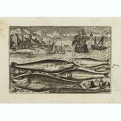
Faber piscis, Asellus minor, Conger, Alburinus. (Piscium Vivæ Icones - Fish)
Depiction of Faber piscis, Asellus minor, Conger, Alburinus. Fish set against a mountainous landscape in the manner of Pieter Brueghel the Elder. Plate number 14. The eng...
Place & Date: Antwerp, after 1598

Lo Stati Presente di Tutti i Paesi e Popoli del Mondo..
This most uncommon work provides an interesting focus on the dissemination of the outline of Japan provided by Kaempfer. Beside the description of Japan, the book include...
Place & Date: Venice, 1734
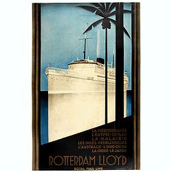
Rotterdam Lloyd, Royal Mail Line. La Méditerranée - L' Egypte - Ceylan - La Malaysie - Les Indes Néerlandaises - L' Australie - L' Indo-Chine - La Chine - Le Japon.
Johann von Stein made this iconic poster for the Rotterdam Lloyd in 1930. This is the rare French version for the tour from Rotterdam to Australia.Johann von Stein (Dutch...
Place & Date: Rotterdam, 1930
![Imposita saxo Jacob cervice quiescens Aligeros scalas vidit imre choros. Gene[sis] 28](/uploads/cache/47690-250x250.jpg)
Imposita saxo Jacob cervice quiescens Aligeros scalas vidit imre choros. Gene[sis] 28
A superb example of this illustration showing a blind Isaac blessing Jacob. Copper engraving published in " Thesaurus sacrarum historiarum veteris testamenti, elegan...
Place & Date: Antwerp, 1585
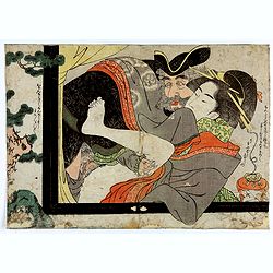
Dutchman and a Maruyama prostitute.
An explicit scene of a Dutchman and a Maruyama prostitute featuring a gray-bearded westerner coupling with a courtesan. The woman protests that she doesn't understand wha...
Place & Date: Late Edo, 1790
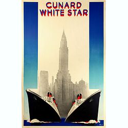
Cunard White (Queen Mary et Queen Elizabeth de la Cunard Line).
Rare original vintage travel advertising poster for Cunard White Star, the fastest Ocean Service in the World. Stunning Art Deco style illustration of the two majestic fl...
Place & Date: Paris, 1938
Temperance (Temperantia) from The Virtues.
Very decorative engraving by Philip Galle (Haarlem 1537–1612 Antwerp) after Pieter Bruegel the Elder (Breda (?) ca. 1525–1569 Brussels). The print was published by Hi...
Place & Date: Antwerp, Hieronymus Cock, 1580

Carta prima Generale dell' Asia.
FIRST STATE of Robert Dudley's general chart of the Persian Gulf, going east through India to the southeastern coast of China showing Macau and the area of present-day Ho...
Place & Date: Florence, 1646

Belgii sive Germaniae Inferioris accuratissima tabula.
Very rare and very decorative map with in the right and left borders costumed figures and town plans alternately. In top and bottom border town plans and views.Separate p...
Place & Date: Amsterdam, 1631

Rooseveld rekende verkeerd ! De vangarmen van De Dollarpoliep worden afgesneden. . .
An remarkable Anti-American Dutch World War II propaganda poster by Lou Manche, showing an pink octopus, representing the United States, with its tentacles being cut from...
Place & Date: The Netherlands, 1942

Horizon ring for globe.
Printed horizon ring for a 28cm diameter German globe. The ring is divided in quarters and engraved two by two on one copper plate. The size of the paper is 44 x 33cm. Th...
Place & Date: Nuremberg, 1704/1705
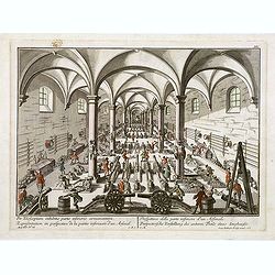
Per telecopium exhibitio partis inferioris armamentarii. / Representation en perspective de la partie inferieure d'un arsenal. . .
RARE. Engraved optical print by Georg Balthasar Probst of a arsenal.
Place & Date: Augsburg, 1750
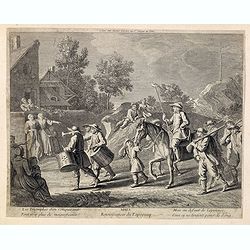
MARS Rejouissances du Papeguay. Les Triomphes d'un conquerant
Etching published by Louis Charles Desnos (1725-1805) with address of rue St.Jacques au Globe. He is also known for his output of wall maps and atlases.
Place & Date: Paris, 1782
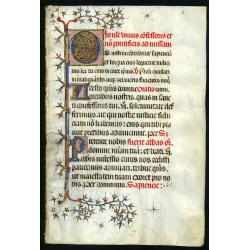
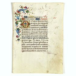
Leaf on vellum from a Missal.
A very fine Missal leaf, written in Latin. RECTO: A wonderful initial O decorated with pen work in red, purple and blue. The initial is 6x6cm. VERSO: one initial "I&...
Place & Date: France, c. 1410

Carte du Palatinat du Rhin.
Decorative "carte à figures"- map centered on Koblenz, Metz, Strasburg, Manheim and Heidelberg, with the river Rhine by François Jollain (ca. 1641 – 18 Apri...
Place & Date: Paris, ca. 1688

't Hooge Heemraedschap van Delfland met alle de Steden, Dorpen, Ambachten, Litmaten, Polders, (etc.).
The so-called Kruquius map is a wall-map of the Delfland water board district. The map consists of 25 engraved map sheets. Several maps flanked by fine large armorial car...
Place & Date: Delft, 1712-1750

L'Art arabe d'après les monuments du Kaire depuis le VIIe siècle jusqu'à la fin du XVIIIe.
Prisse d’Avennes was one of the foremost scholars of Arabic art and architecture of the 19th century; this work represents the summation of his studies. From the aspect...
Place & Date: Paris, Morel, 1877

Tafel der Lender darin der Apostel Paulus geprediget hat.
Rare wood block map depicting the Mediterranean, with an over-sized Cyprus from the final Dutch edition of Heinrich Bünting's famous Itinerarium Sacrae Scripturae, a boo...
Place & Date: Magdeburg, 1581
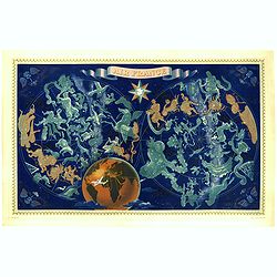
AIR France - Réseau Aérien Mondial.
Original pictorial lithograph advertising planisphere poster from AIR France. The poster has a black background. In the lower right below the border '016/P/AF Printed in ...
Place & Date: Imprimerie Perceval, Paris, ca. 1950
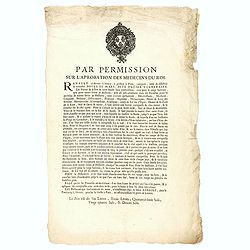
Par permission sur l'aprobation des médecins du roi...la véritable Boule de Mars...
Printed broadsheet promoting the "Boule de Mars" (March Ball) produced and sold by Renault in Nancy and Paris. Ornated with the royal coat of arms of France. Pr...
Place & Date: Paris, ca.. 1780

Kaart Van Nieuw Zeeland in de Jaaren 1769 en 1770 bezogt door den Luitenant J. Cook met het Schip De Endeavour.
A uncommon issue of this key map of New Zealand from the Dutch edition of Cook's map of New Zealand, published in 'Reize rondom de Waereld door James Cook', a Dutch editi...
Place & Date: Leyden, Amsterdam & The Hague: Honcoop, Allart & van Cleef, 1795-1801

Waere Affbeeldinge Wegens het Casteel ende Stadt BATAVIA Gelegen opt Groot Eylant Java.
A good impression of this finely engraved and detailed plan of Batavia, present-day Jakarta, the Dutch center of trading activities in the East Indies. Copied after Cleme...
Place & Date: Amsterdam, 1721
20 advertising gouaches for tobacco industry.
A stunning collection of 20 original square and rectangular decorative commercial designs for the Tabaco industries in gouache and watercolor by the artist and graphic de...
Place & Date: Paris, ca. 1930

A newe mape of Tartary.
Early edition of one of the most decorative "carte à figures"- map of Tartary, known for its figured borders with costume figures, while above are vignettes of...
Place & Date: London, 1627
![Boats of the Friendly Islands. [together with] A Sailing Canoe of Otaheite.](/uploads/cache/30041-250x250.jpg)
Boats of the Friendly Islands. [together with] A Sailing Canoe of Otaheite.
Early view of Queen charlotte's sound, taken from "Views in the South Seas" being a very important and early views depicting scenes encountered while employed a...
Place & Date: London, Boydell and Co., 1808

The narta, or Sledge for burdens in Kamtschatka.
The narta, or Sledge for burdens in Kamtschatka, taken from "Views in the South Seas" being a very important and early views depicting scenes encountered while ...
Place & Date: London, Boydell and Co., 1808
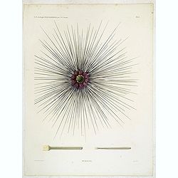
Oursins.
Decorative plate of a sea urchin, engraved by Boquet. Marie Jules César Lelorgne de Savigny (April 5, 1777 - October 5, 1851) was a French zoologist. In 1798 he traveled...
Place & Date: Paris, 1822
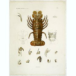
Hommards.
Decorative engraving of a lobster, by Tresca. Marie Jules César Lelorgne de Savigny (April 5, 1777 - October 5, 1851) was a French zoologist. In 1798 he traveled to Egyp...
Place & Date: Paris, 1822
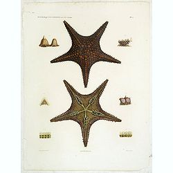
Astéries.
Decorative engraving of star fishes, by Macret and Leleu. Marie Jules César Lelorgne de Savigny (April 5, 1777 - October 5, 1851) was a French zoologist. In 1798 he trav...
Place & Date: Paris, 1822

(Art déco gouache with winter scene of The Palace of Westminster )
Outstanding "art deco" gouache (unsigned) from the workshop of "Robert Pichon. Ateliers de Dessin et Lithographie – 10, rue Rochechouart – Paris. The ...
Place & Date: Paris, ca. 1930

Comitatus Flandria.
A highly decorative map with in the left and right top corners the pictures of archduke Albert of Austria and Isabella, queen of Spain. In the left and right borders cost...
Place & Date: Amsterdam, 1648
![[Map of Palestine ]](/uploads/cache/42176-250x250.jpg)
[Map of Palestine ]
Map of Palestine from "La Mer des Hystoires" published by Dupré, Paris, 1536 "La Mer des Hystoires" is a translation into French of the famous "...
Place & Date: Dupre, Paris, 1536
![Province de Fo-Kien. [Includes West Coast of Taiwan]](/uploads/cache/43503-250x250.jpg)
Province de Fo-Kien. [Includes West Coast of Taiwan]
Important map of Fujian Province, showing the east coast of China and the west coast of Taiwan. It shows that for the Manchu Qing, only the western half of Formosa was co...
Place & Date: The Hague, H. Scheurleer, 1737

Tabula Russiae.
One of the most decorative maps of Russia, based on the work of Fedor Borisovich. Visscher's version of Hessel Gerritsz' rare map of Russia. In an inset -130x170mm- a pla...
Place & Date: Amsterdam, 1651

Carriers of the New Black Plague.
A powerful satirical commentary on totalitarian control of speech from the first issue of Ken Magazine. "Caught here in all their peculiar beauty by the soul searchi...
Place & Date: Chicago, 1938
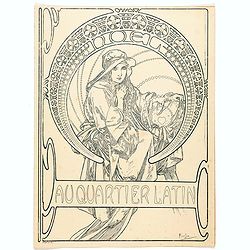
Au quartier Latin.
This image also appears on the Christmas cover of the magazine in 1900. This is the version before the magazine boilerplate was added, but "this black-and-white vers...
Place & Date: Paris, ca. 1899
![Amerique Septentrionale divisée en ses principales parties. . .1692. [California as an Island]](/uploads/cache/27961-250x250.jpg)
Amerique Septentrionale divisée en ses principales parties. . .1692. [California as an Island]
A very good impression of Jaillot's large map of North America, showing California as an Island, based upon Sanson's landmark map of 1656. A first state.The map shows the...
Place & Date: Amsterdam, c.1692

Christophorus Columus Ligur Indiarum Prim invet A°1492
Very decorative portrait of Christopher Columbus (c. 31 October 1451 – 20 May 1506), engraved by Theodor de Bry (1528-1593) and published in Jean Jacques Boissard, &quo...
Place & Date: Frankfurt a.M. 1597 - 1599

Archipelague du Mexique ou sont les Isles de Cuba..
Scarce map of Caribbean. A visually stunning map with a large title cartouche. This large one-sheet map was produced by the Venetian cosmographer Vincenzo Coronelli when ...
Place & Date: Paris, 1688

Kunst is allemaal flauwe kul.
Joop Schafthuizen is a Dutch artist known for his prints. He inspired some of the books written by his partner, the famous writer Gerard Reve. "Kunst is allemaal fla...
Place & Date: Rotterdam, 1976
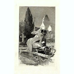
A rare suite of 12 original etchings by Martin van Maele to the famous work by Edmond Haracourt.
A rare suite of 12 original etchings by Martin van Maele to the famous work by Edmond Haracourt. The series was published anonymously in a small edition. These etchings a...
Place & Date: Nevers, Brussels, 1882,1883

Orbis Terrae Compendiosa Descriptio.
Gerard Mercator's great world map of 1569 was condensed into double hemispherical form by his son Rumold. It first appeared in 1587 in Casaubon's edition of Strabo's Geog...
Place & Date: Amsterdam, 1595-1609

Waere affbeeldinge wegens het casteel ende stadt Batavia.
A good impression of this finely engraved and detailed plan of Batavia, present-day Jakarta, the Dutch center of trading activities in the East Indies. Copied after Cleme...
Place & Date: Amsterdam, 1681

Sincapour.
Early view of Singapore after Paris and engraved in aquatint technique by Sigismond Himely (1801-1872). Published as plate 28 in Voyage autour du monde par les mers de l'...
Place & Date: Paris, Finot, 1835
![ATLAS RUSSICUS mappa una generali et undeviginti specialibus vastissimum Imperium Russicum cum adiacentibus regionibus [repeated in French].](/uploads/cache/27877-250x250.jpg)
ATLAS RUSSICUS mappa una generali et undeviginti specialibus vastissimum Imperium Russicum cum adiacentibus regionibus [repeated in French].
After an unnumbered general map of Russia there are 13 numbered maps that cover European Russia (scale 1, 1.527.000). The other (last) 6 maps cover Asian Russia (Siberia,...
Place & Date: St Peterburg, Akademie von Wissenschaften. 1745

Plan du Port de St Augustin dans la Floride.
This chart shows a plan of the Port of St. Augustine in Florida.The only issue of this version of Bellin's map, slightly larger than the common version. Depths shown by s...
Place & Date: Paris, 1764
![[Magazine including pictorial world map, Carriers of the New Black Plague by William Cotton.]](/uploads/cache/43680-250x250.jpg)
[Magazine including pictorial world map, Carriers of the New Black Plague by William Cotton.]
Front cover with color illustration of Moroccan male sheik and yellow lettering.Oversized magazine, features analysis of English justice, map of Herr Hitler's heaven (ful...
Place & Date: Chicago, April 7th, Vol.1 No.1 1938
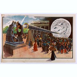
La Lune à un Mètre [Mini poster for Paris Exposition Universelle)
Original lithograph poster for "Paris Exposition Universelle" held between April and November, 1900, which received 50 million visitors. In 1899, director Geor...
Place & Date: Paris, c.1900

Turcici Imperii Imago.
The map shows the Ottoman Empire with Turkey, Black Sea, Mediterranean Sea, Arabia and North Eastern Africa. The map is decorated with a title cartouche and a portrait of...
Place & Date: Amsterdam, 1629

Map of Louisiana from D'Anville's Atlas.
This map presents a highly detailed treatment of the region from Cabo Del Norte to the Apalachiola River, centered on the mouth of the Mississippi and extending inland to...
Place & Date: London, 1788

Stoel des Oorlogs in America Waar in Vertoont Werden Alle Desself Voornaamste Eylande . . .
Large impressive map of the West Indies with the Gulf of Mexico and Florida. The map shows prominently in the center Cuba, Haiti, the Bahamas and Florida, which is here m...
Place & Date: Amsterdam, c. 1720

Lutetia Furens. Das ist : Die wütende Statt PARIS.
Rarissime placard dirigé contre la Ligue et le duc de Mayenne. La gravure est signée I.S. (marque inconnue). Ce placard en latin et en allemand est une reprise de l’e...
Place & Date: France ca.. 1594
![Jules Verne Le Tour du Monde en 80 jours. [Goose game board inspired by Jules Verne's novel Tour du Monde en 80 jours.]](/uploads/cache/44919-250x250.jpg)
Jules Verne Le Tour du Monde en 80 jours. [Goose game board inspired by Jules Verne's novel Tour du Monde en 80 jours.]
Goose game board inspired by Jules Verne's novel, whose boxes are illustrated with color lithographs and the center occupied by a world map. Vignette illustrations number...
Place & Date: Paris, ca. 1880

Nouvelle carte des mers comprises entre le détroit de Banca et P°. Timon avec la partie orientale du détroit de Malacca.
Important French chart of the tip of Malaysia with Singapore. Latitude and longitude scales, compass rose and system of rhumb lines, soundings near coast and in bay areas...
Place & Date: Paris, 1745

Carte des Trois Arabies. Tiree en Partie de l'Arabe de Nubie, en Partie de Divers autres Autheurs. . .
Rare map of the Arabian Peninsula, first published in 1654 and one of the first large maps focused specifically on the Arabian Peninsula. Sanson's map of the Arabian Peni...
Place & Date: Paris, 1654

Ignographia candiae tertia a turcis obsessae in lucem edita a F. de Wit.
A scarce broadsheet plan and view of Heraklion on one sheet: prospect 180 x 495mm, map 395 x 495mm., in the lower part a printed description "Abbildung der starken S...
Place & Date: Amsterdam, 1680

Trop d'Appetit par A. Le Petit.
Dated in lower right dated "Le 9 juin 1875". The drawing is representing an alligator's jaw wearing a Prussian helmet, and about to chew a globe. Alfred Le Peti...
Place & Date: Paris, 1875

Province de Pologne contenant 22 Col. une M.on Prof 5 Pen. 2 Nov. 6 Rés. 30 Maisons 1050 Jésuites.
Rare map of Poland from "Atlas Universel indiquant les établissemens des Jésuites: avec la manière dont ils divisent la terre, suivi desévénemens remarquables d...
Place & Date: Paris, Ambroise Dupont , 1826
Leaf on vellum from an Italian manuscript Book of Hours.
A leaf from an Italian Book of Hours, written on vellum in the neighborhood of Ferrara, around 1480.The decorations of this leaf are extraordinary : the bouquet of flower...
Place & Date: Italy, Ferrara, ca.1480
![[Manuscript chart on vellum of the Java Sea]](/uploads/cache/33613-250x250.jpg)
[Manuscript chart on vellum of the Java Sea]
One of the few manuscript charts on vellum in private hands, signed by Isaac de Graaf. ORIGINAL MANUSCRIPT MAP IN RED, GREEN AND BLACK INK showing the Java Sea centered o...
Place & Date: Amsterdam, 1743

Frisia occidentalis.
A rare separately published carte-a-figures of Friesland by Geelkercken in its first state. The title and the coats of arms of the eleven Frisian towns appear in the cent...
Place & Date: [Leeuwarden], Dierick Albertsen, 1618

Amstelodamum, Celebre Emporium Forma Plana.
Second state of this rare and decorative plan of Amsterdam with Visscher's imprint. With a panoramic view seen from the IJ and further insets of Council House, The Exchan...
Place & Date: Amsterdam, c. 1636

Composite atlas of the Low Countries.
A composite atlas comprising 18 double-page engraved maps by or after Hessel Gerritsz, Theodoor Galle, Jacob van Deventer, Gerard Mercator, Peter Verbiest, Jean Surhon, C...
Place & Date: [Antwerp, c. 1633

Naaukeurige Platte Grond van den Staat en den Loop van Rio de Berbice Met derzelver Plantagien in de Geoctrojeerde Colonie de Berbice Gelegen. . .
Uncommon large-scale map of Berbice with Rio de Berbice and Rio de Canjewith at the bottom left a list of plantation owners. In top 3 x 3 coats of arms in cartouches. The...
Place & Date: Amsterdam, 1742

Original copperplate.
Showing the coast of southern Morocco, the Sahara with the Canary Islands. Copperplates that had been used in the production of early maps are of the greatest rarity and ...
Place & Date: Amsterdam, ca. 1660

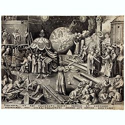
Mercurius.
Mercury holding a caduceus and riding in a chariot drawn by two birds on the clouds in the sky, an extensive landscape with a harbor with goods being loaded and unloaded ...
Place & Date: Antwerp, 1585

Lapis polaris magnes.
This is a plate from a series of twenty prints illustrating new inventions and discoveries (Nova Reperta) after Jan van der Straet. On image, bottom right: 'Ion. Stradanu...
Place & Date: Antwerp, Philips Galle, c. 1590

Xantung, sinarum imperii provincia quatra.
A map of the northern province ‘Xantung’ of China after the Jesuit Martino Martini.Shows the Great Wall and is centered on the Bohai Sea, and the Shandong and Liaonin...
Place & Date: Amsterdam, ca 1660

Insula Huaena sive Venusia a Guiljelmo Blaeu cum sub Tychone Astronomiae operam daret, delineata.
Decorative map of the island Hvan in the Danish Sound. In the center Tycho Brahe's famous observatory Uraniborg established in 1576, under the patronage of Frederick II, ...
Place & Date: Amsterdam, 1659
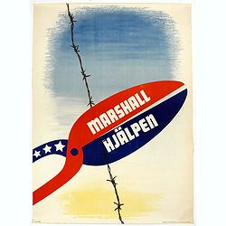
Marshall Hjälpen.
Marshall Plan poster made by Gusta Aberg, showing barbed wire cut by pliers with slogan on pliers: Marshall Hjälpen This is one of the 25 finalists in the 1950 “Intra-...
Place & Date: Kühn & Zoon Rotterdam, 1950

Nova XVII Provinciarum Inferioris Germaniae descriptio .
Extremely rare map of the Benelux by Frederick de Widt. Originally engraved and published by P.Kaerius in 1607. In 1662 the plate came in the possession of Frederick de W...
Place & Date: Amsterdam, 1662

Mapa geogra´fico de la mayor parte de la Ame´rica Meridional que contiene los paises por donde debe trazarse la li´nia divisoria que divida los dominios de Espan~a y Portugal. . .
Rare first edition of the map drawn by Francisco Requena (1743-1824) after his expedition to the Amazon in order to delineate the boundary between the Spanish and Portugu...
Place & Date: Bourquin, F. Philadelphia, ca. 1876
![Le Sacre Hagard [Haggard-falcon]](/uploads/cache/44315-250x250.jpg)
Le Sacre Hagard [Haggard-falcon]
A beautiful elephant folio sized colored lithograph of a Hagard Falcon, taken from the famous book on Falconry Traite de Fauconnerie by Schlegel and A.H. Verster van Wulv...
Place & Date: Leiden, 1844-1853

Daniae regni typum . . .
Second Edition, now for the first time with a date (1630), this rare map which - like that of Janssonius-Kaerius - is based on John Speed's map of 1626. The side borders ...
Place & Date: Amsterdam, 1630

Cunard to Canada.
Poster by Charles Eddowes Turner for Cunard lines. The poster shows The NEW SYLVANIA, one of the four new 22,000 - ton Cunarders which are the largest ever built for serv...
Place & Date: England, ca. 1930

Carta terza Generale del' Asia.
Rare first state of this important chart showing part of the north coast of New Guinea and islands of the Pacific Ocean. To the north of Japan the landmass of Isola di Ie...
Place & Date: Florence, 1646

Ducatus Prussiae tam Polono Regiae. . .
This is a rare issue of Frederick de Wit's attractive map of the northern part of Poland, Prussia and the Baltic regions.Very decorative title cartouche, including three ...
Place & Date: Amsterdam, 1698

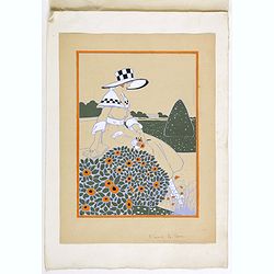
(Art déco gouache)
Outstanding "art deco" gouache (unsigned) from the workshop of "Robert Pichon. Ateliers de Dessin et Lithographie – 10, rue Rochechouart – Paris. The g...
Place & Date: Paris, ca. 1930
(Art déco gouache)
Outstanding "art deco" gouache (unsigned) from the workshop of "Robert Pichon. Ateliers de Dessin et Lithographie – 10, rue Rochechouart – Paris. The g...
Place & Date: Paris, ca. 1930