Browse Listings

The Harbour of Casco Bay and Islands Adjacent Bt Capt. Cyprian Southicke.
The earliest printed chart of Casco Bay, an inlet of the Gulf of Maine on the southern coast of Maine, New England. First issued in 1720 by Mount and Page, it remained in...
Place & Date: Dublin, 1767

Tabula Russiae.
One of the most decorative maps of Russia, based on the work of Fedor Borisovich. Visscher's version of Hessel Gerritsz' rare map of Russia. In an inset -130x170mm- a pla...
Place & Date: Amsterdam, 1651
![[Il mondo a pezzi - Europa].](/uploads/cache/42849-250x250.jpg)
[Il mondo a pezzi - Europa].
Satirical representation of the division of the world by the main European powers. At the center of the scene a globe on which is written "MONDO Maledeto Interesse ...
Place & Date: Bologna, 1690
![[Map of Palestine ]](/uploads/cache/42176-250x250.jpg)
[Map of Palestine ]
Map of Palestine from "La Mer des Hystoires" published by Dupré, Paris, 1536 "La Mer des Hystoires" is a translation into French of the famous "...
Place & Date: Dupre, Paris, 1536

Carte d'unne partie de l'Arabie Septentrionale Pour suivre les Voyages de Mr. G.A. Vallin. . .
This is the original hand-drawn map by Victor Adolphe Malte-Brun of "Carte d'unne partie de l'Arabie Septentrionale Pour suivre les Voyages de Mr. G.A. Wallin",...
Place & Date: Paris, November 1855

La Pieuvre Germanique.
Scarce lithographed plate not dated, by Eugène Danzanvilliers, printed by Grandremy in Paris. The plate listed by Adhemar is dated 1874. Eugène Danzanvilliers was a dra...
Place & Date: Paris, 28 Quai de la Rapée, c.1874

Mapa geogra´fico de la mayor parte de la Ame´rica Meridional que contiene los paises por donde debe trazarse la li´nia divisoria que divida los dominios de Espan~a y Portugal. . .
Rare first edition of the map drawn by Francisco Requena (1743-1824) after his expedition to the Amazon in order to delineate the boundary between the Spanish and Portugu...
Place & Date: Bourquin, F. Philadelphia, ca. 1876

Waere affbeeldinge wegens het casteel ende stadt Batavia.
A good impression of this finely engraved and detailed plan of Batavia, present-day Jakarta, the Dutch center of trading activities in the East Indies. Copied after Cleme...
Place & Date: Amsterdam, 1681

Bern in der Schweitz.
Very fine panoramic of Bern. With a numbered key (1-25) of principal buildings in town.
Place & Date: Augsburg, 1740
![Venecie. [Venice] Foliu XLIIII](/uploads/cache/29716-250x250.jpg)
Venecie. [Venice] Foliu XLIIII
A very fine of Venice (192x525mm.) Verso a view of Padua. Schedel's view of Venice is one of the earliest obtainable views of the city. The view is based on the view of ...
Place & Date: Nuremberg, 12 July 1493

Runde Strasse in Peking.
Finely executed water color made by Henri Dieth of a charming street scene in Peking. The water color is made after Eduard Hildebrandt (1818-1869). Hildebrandt, was born ...
Place & Date: Germany, 1882

Valletta citta nova dimalta.
Early copper engraved map of the towns of Valletta, Borgo, Sanglea di Sto. Michele, and the church of St. Salvator -known as the Three Cities., engraved by Henry Raignaul...
Place & Date: Paris, Michael Soly, 1629

Carta terza Generale del' Asia.
Rare first state of this important chart showing part of the north coast of New Guinea and islands of the Pacific Ocean. To the north of Japan the landmass of Isola di Ie...
Place & Date: Florence, 1646

SETTSU MEISHO ZUE. Illustrations of famous places in Settsu.
Settsu Meisho Zue was printed in two series of 8 and 4 volumes. The principal illustrator was Takehara Shunchosai, but many illustrations in the 4 volumes supplement are ...
Place & Date: Osaka, Yanagiwara Kibei, Kansei 8-10 or 1796-1798

Ducatus Prussiae tam Polono Regiae. . .
This is a rare issue of Frederick de Wit's attractive map of the northern part of Poland, Prussia and the Baltic regions.Very decorative title cartouche, including three ...
Place & Date: Amsterdam, 1698

Urbium Londini et West-Monasterii nec non Surburbii Southwark Accurata Ichnographia ,., Neuester Grundris der Staedte London und West-Munster, Samt der Vorstadt Southwark ,.,
Detailed plan of London, extending from Grosvenor Square in the west to Mile End to the east, To the right inset views of St, James's Square, and Custom House, elevations...
Place & Date: Nuremberg, 1736

Carte de la Charte de L'Antique . . .
The rare French version of this decorative pictorial world map by MacDonald Gill. "This magnificent map drawn up while the Second World War still raged is already en...
Place & Date: London, Alf Cooke Ltd, 1943

Belgii sive Germaniae Inferioris accuratissima tabula.
Very rare and very decorative map with in the right and left borders costumed figures and town plans alternately. In top and bottom border town plans and views.Separate p...
Place & Date: Amsterdam, 1631

(The City And Harbour Of Sydney From Near Vaucluse.)
One of the most sought after views of the city and harbour of Sydney seen from Near Vaucluse, 1852. Magnificent hand-colored tinted lithograph and finished by gum-Arabic....
Place & Date: London, J. Hogarth, 1852

Pascarte van Europa Beginnende vande Canael tot aen Spitbergen, en van Ysland tot aen Nova Zemla . . .
An eye-catching chart of northern Europe with a coastline from northern Russia to the Dutch English Channel in the south. Good detail on Iceland. North to the top.In the ...
Place & Date: Amsterdam, after 1666
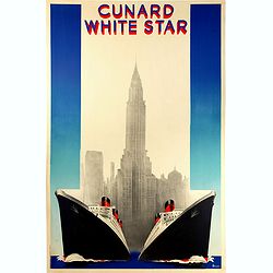
Cunard White (Queen Mary et Queen Elizabeth de la Cunard Line).
Rare original vintage travel advertising poster for Cunard White Star, the fastest Ocean Service in the World. Stunning Art Deco style illustration of the two majestic fl...
Place & Date: Paris, 1938

Hydrograhica descriptio
This very rare chart is important as the first printed sea chart of the Mediterranean coast of Spain, Gibraltar, also depicting the northern coast of Marocco.Willem Bar...
Place & Date: Amsterdam, W.Blaeu, 1612

Carolinae Floridae nec non Insularum Bahamensium cum partibus adjacentibus delinatio ad Exemplar Londinense in lucem edita . . . Ao. 1755.
The German edition of this map of Carolina, Florida, and the Bahama Islands in full original colors. Published in Seligmann's "Sammlung verschiedener auslaendischer ...
Place & Date: Nuremberg, 1755

Angliae, Scotiae, et Hiberniae, sive Britannicar : Insularum descriptio.
A rare and ornate map with inset portraits of James First, Henry Prince of Wales Princess Anne of Denmark.Janssonius acquired the copperplate of van den Keere's 1604 Brit...
Place & Date: Amsterdam, 1621

Terra Promissions.
A beautifully executed and very rare map of the Promised Land, divided into the 12 Tribes. The shore line runs in north-southwesterly direction from Sidon as far as Pelus...
Place & Date: Paris, c.1655

Germania.
Second state of this rare "carte à figures"- map of Germany, The Netherlands, Poland and central Europe. Bordered on three sides with portraits and views. In t...
Place & Date: Amsterdam, 1607
![Carte de la coste orientale de la Chine depuis Amoy, jusqu'à Chusan avec une partie de l'Isle Formose [with] Plan du port d'Amoy ou Emouy.](/uploads/cache/33583-250x250.jpg)
Carte de la coste orientale de la Chine depuis Amoy, jusqu'à Chusan avec une partie de l'Isle Formose [with] Plan du port d'Amoy ou Emouy.
Important French chart of the China Sea with the coast of Northern China, including a large depiction of Formosa.Latitude and longitude scales, compass rose and system of...
Place & Date: Paris, Jean-François Robustel, 1745

A Map of the Environs of Constantinople Drawn from a great number of accurate astronomical & geographical manuscripts and printed documents, by A. Arrowsmith 1801 and 1804.
Arrowsmith’s large and detailed map of the Ottoman Empire and the Black Sea, with Cyprus, Crete and the Greek Islands in the Mediterranean Sea, Albania, Bosnia and Herz...
Place & Date: London, No.10 Soho Square, 4th September 1804
![[Set of 6 maps] Charta öfver Storfurstendömet Finland på Friherre S. G. Hermelins Anstalt och Omkostnad. Sammandragen och författad af C. P. Hällström. Philos. Magister och Auscultant i Kongl. BergsColl. 1799.](/uploads/cache/34482-250x250.jpg)
[Set of 6 maps] Charta öfver Storfurstendömet Finland på Friherre S. G. Hermelins Anstalt och Omkostnad. Sammandragen och författad af C. P. Hällström. Philos. Magister och Auscultant i Kongl. BergsColl. 1799.
This is the beautiful set of key map and separate maps of Samuel Gustav Hermelins map of Finland. The maps have been engraved by Fredrik Akrel, a very skilled and product...
Place & Date: Källa: J.Strang & E.- S. Harju: Suomen karttakirja 1799

A Map of the most Inhabited part of New England containing the Provinces of Massachusetts Bay and New Hampshire, with the Colonies of Connecticut and Rhode Island.
A copper engraving in four sheets, published in Georges Louis Le Rouge, in his "Atlas Ameriqua in Septentrional Contenant les details des differentes provinces, de c...
Place & Date: Paris, 1777

I Europa / Das dritteil der Welt.
Very early wood cut printed map of Europe with South to the top. In the lower-left corner we see Poland, Livonia and parts of England and Ireland in the lower right corne...
Place & Date: Zurich, Christoffel Froschover, 1548,1552-1566

Tabula nova Poloniae et Silesiae.
Second state, dated 1630 underneath the title. A finely engraved carte á figures with cartouche representing in the four corners of the map : Kings ( on the left side Si...
Place & Date: Amsterdam, 1630

Asia secunda pars terrae in forma Pegasi.
Asia depicted as the flying horse Pegasus. Thiscartographical curiosity, double page copper engraved map, was published in Heinrich Bünting's “Itinerarium Sacrae Scrip...
Place & Date: Brunswick, 1640

Tabula nova utriusque Indiae.
This is the fourth and last edition of this map based on Waldseemüller's first "modern" map of Asia. It follows that cartography without change but adds an int...
Place & Date: Vienne, 1541

Nieuwe en Nette Afteekening van het Eyland Corsica en het Eyland Elba vertoonende alle desselfs Havenen, Steeden en Rivieren . . .
Highly decorative large sea chart of Corsica, Sardinia and Elba, including multiple sailing ships, compass roses, cartouche, coat of arms, rhumb lines, topographical deta...
Place & Date: Amsterdam, ca. 1710

Naaukeurige Platte Grond van den Staat en den Loop van Rio de Berbice Met derzelver Plantagien in de Geoctrojeerde Colonie de Berbice Gelegen. . .
Uncommon large-scale map of Berbice with Rio de Berbice and Rio de Canjewith at the bottom left a list of plantation owners. In top 3 x 3 coats of arms in cartouches. The...
Place & Date: Amsterdam, 1742

Lutetia Furens. Das ist : Die wütende Statt PARIS.
Rarissime placard dirigé contre la Ligue et le duc de Mayenne. La gravure est signée I.S. (marque inconnue). Ce placard en latin et en allemand est une reprise de l’e...
Place & Date: France ca.. 1594

(Sea-chart of Catalunia, Languedoc, Provence, Cote d'Azur, Riviera, Corsica with Marseille, Cannes, Nice, Monaco.)
This very rare chart is important as the first printed sea chart of France's Mediterranean coast, also depicting Catalunya's northern coast, the Italian Cote d'Azur till ...
Place & Date: Amsterdam, 1607
![[Crimea]. Carte de la Cromée.](/uploads/cache/25719-250x250.jpg)
[Crimea]. Carte de la Cromée.
Mapmaker, Captain Jan Hendrik van Kinsbergen (1735-1819). Published by H. Friesman in 1787. This map first appeared in 1776 and was the first Russian map of the newly ann...
Place & Date: Amsterdam, H. Frieseman, 1787

Nouvelle Mappa Monde.
State 2 of this fine double hemisphere world map, from an unusual perspective, with a "Mer de L'Ouest" or "Sea of the West". Paris is located at the c...
Place & Date: Venice, 1776 - 1784

Carte des côtes du Golfe du Mexique compris entre la pointe sud de la presqu'Ile de la Floride et la pointe nord de la presqu'Ile d'Yucatan: Dresée d'après le observations et las plans des espagnols, ...
Detailed and important early chart of the Gulf Coast and Florida and dated 1800. First French edition of "the first printed [map] to show and name Galveston Bay&qu...
Place & Date: Paris, 1800

Nova Helvetiae Tabula.
A most decorative "carte à figures" map with panoramic views of Lucern, S.Gal, Bern, Solothurn, Schafhausen in upper border and Basel and Zurich in lower left ...
Place & Date: Amsterdam, 1630

Pas-Kaat vaneen gedeelte van de Aethiopische Zee behelsende de Kusten Zanguebar, Ajan en Abex, en een gedeelte van de Arabische Kust. . .
A finely engraved and detailed chart of the most eastern tip of Africa, including Somalia, Djibouti, Yemen, Mauritius, and many other islands in the Indian Ocean.Very rar...
Place & Date: Amsterdam, 1753

Il regno della China detto presentente Catay e Magnin. . .
A rare and decorative Italian map of China and Japan, with Japan closely modelled on the indented Cardim outline and Hokkaido, called Yuppi , shown as an Asian peninsula....
Place & Date: Rome, 1682

Paris.
A spectacular panoramic view of Paris, with legends numbered from 1-70 in French. With the title in a banderol.After a design by Friedrich Bernhard Werner (1690-1776) who...
Place & Date: Augsbourg, ca. 1740
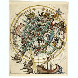
(Northern celestial planisphere with a pasted volvelle.)
Probably by the Vienna astronomer Melchior Klayber who used the Copernican precession theory, which is closely connected with the chart (Ptolemy - 6° 40' and Ptolemy - 5...
Place & Date: Vienna, ca. 1569

L'Africa divisa nelle sue Parti secondo le pui moderne . . .
A beautiful and rare two-sheet map of Africa. The title cartouche is depicted on a drape surrounded by native animals.A most noticeable feature of the decoration on the m...
Place & Date: Venice, 1690

Pascaerte vande Caribische Eylanden, vande Barbados tot aende Bocht van Mexico ‘t Amsterdam By Hendrick Doncker. . .
First state. Rare. “This chart appeared in the first edition of Hendrick Doncker’s Zee-Atlas, of which no surviving example is known” -- Burden. This is an example ...
Place & Date: Amsterdam, 1659

Calendrier de la cour, tiré des éphémérides, pour l'Année bissextile.. / Notebook bearing silver plates with the VOC monogram.
A personal gift, only made for the trustees of the V.O.C. The silver plate was probably made by Drick van Hengel and Company because an entry in the diary of mintmaster J...
Place & Date: Paris, 1787

Frisia occidentalis.
A rare separately published carte-a-figures of Friesland by Geelkercken in its first state. The title and the coats of arms of the eleven Frisian towns appear in the cent...
Place & Date: [Leeuwarden], Dierick Albertsen, 1618
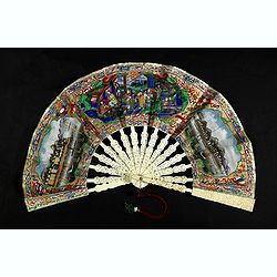
A fan combines views of Hong Kong (right), Canton (left), China, ca 1850-1860.
The fan shows nice images of Hong Kong and Canton on onside and on verso a garden with 39 characters welcoming a rider on his white horse. Their clothes are heightened in...
Place & Date: China, ca. 1850-1860

't Hooge Heemraedschap van Delfland met alle de Steden, Dorpen, Ambachten, Litmaten, Polders, (etc.).
The so-called Kruquius map is a wall-map of the Delfland water board district. The map consists of 25 engraved map sheets. Several maps flanked by fine large armorial car...
Place & Date: Delft, 1712-1750
![[Printed on silk] Nova Totius Americae Sive Novi Orbis Tabula, Auct. Hugo Allardt.](/uploads/cache/48420-250x250.jpg)
[Printed on silk] Nova Totius Americae Sive Novi Orbis Tabula, Auct. Hugo Allardt.
Hugo Allard’s ca. 1661 map of the Americas, showing California as an island printed on silk. This separately issued map printed on paper is quite rare on the market. T...
Place & Date: Amsterdam, 1661

The Rubaiyat of Omar Khayyam (Edward Fitzgerald translation)
Edward FitzGerald, an outstanding writer who has done more than anyone to popularise English poetry. His best-known work, The Rubaiyat of Omar Khayyam (1859), began by be...
Place & Date: England, ca. 1930

Nova Orbis Tabula in Lucem edita A.F.de Wit.
According to Shirley, De Wit's map is one of the most attractive of its time. The brilliant scenes in the corners combine images of the four seasons, the elements, and th...
Place & Date: Amsterdam, 1680

Quinta Asie Tabvla.
Woodblock map of Persia from Martin Waldseemüller's 1513 edition of Ptolemy, a landmark work that contributed to major advances in both Renaissance geography and map p...
Place & Date: Strasbourg, J. Schott, 1513

Deliciae Batavicae.
It is a charming book illustrated with portraits of Willem of Orange and Prince Maurits and eight engraved armorial plates. Followed by 30 engraved views or scenes of ...
Place & Date: Amsterdam, Johannes Janssonius, 1618
![[MANUSCRIPT] Carte nouvelle de la Crimée et des pays circonvoisins.](/uploads/cache/30484-250x250.jpg)
[MANUSCRIPT] Carte nouvelle de la Crimée et des pays circonvoisins.
A beautiful manuscript map on paper. Showing the northern part of the Black Sea region with Crimea.Interesting are the border lines of "New Serbia", shown in th...
Place & Date: ca. 1752-1764

Tableau des guerres de Frédéric le Grand: ou plans figurés de vingt-six batailles rangées, ou combats essentiels donnés dans les trois guerres de Silésie. . .
The book includes a large folded map "Tableaux des Guerres de Frédéric le Grand", showing a map of Prussia, with present-day Poland and Eastern Germany surrou...
Place & Date: Potzdam, Strasbourg, Paris, 1788

New Jersey entworfen von D.F. Sotzmann. Hamburg bey Carl Ernst Bohn 1796 . . . NO.VIII
Extremely rare map of New Hampshire prepared by Daniel Friedrich Sotzmann for Christopher Ebeling's "Erdbeschreibung von Amerika", a project ended after only te...
Place & Date: Hamburg, Carl Ernst Bohn, 1797

Rhode Island entworfen von D.F. Sotzmann. Hamburg bey Carl Ernst Bohn 1798 . . . NO.V
Extremely rare map of Rhode Island prepared by Daniel Friedrich Sotzmann for Christopher Ebeling's "Erdbeschreibung von Amerika", a project ended after only ten...
Place & Date: Hamburg, Carl Ernst Bohn, 1797

Asia secunda pars in forma Pegasi.
UNRECORDED PLATE or STATE. Asia depicted as the flying horse Pegasus. Below the depiction 3 lines of engraved Latin text. Double page copper engraved map from Heinrich B�...
Place & Date: Brunswick, ca. 1635

Belgii novi, angliae novae, et partis Virginiae . . .
This example is state 3 of the original Janssonius plate, printed after Schenk acquired the plates at public auction in 1694 from the heirs of Jansson van Waesberge. The ...
Place & Date: Amsterdam, 1694

Nouvelle carte des mers comprises entre le détroit de Banca et P°. Timon avec la partie orientale du détroit de Malacca.
Important French chart of the tip of Malaysia with Singapore. Latitude and longitude scales, compass rose and system of rhumb lines, soundings near coast and in bay areas...
Place & Date: Paris, 1745

(Totius Americae nova et exacta tabula ex) optimis tum geographorum tum aliorum scriptis collecta et ad hodiernam regnorum principatuum et maiorum partium distinctionem accomodata.
Eastern part of a two-sheet map of America, with attribution to Willem Blaeu. According to Philip Burden, the map was derived from Cornelius Danckert's 1647 map of the sa...
Place & Date: Rome, 1679

Tabula Superioris Indiae & Tartariae maioris. (Modern Map of China, Japan, etc.)
Important map extending from Tartary in the north, to "Prov. Bocat" (Cambodia) in the south. "Tebet" is shown prominently, as is "Zinpangri"...
Place & Date: Vienne, 1541

(EUROPE).
A woodcut colored map of northern and central Europe. The first modern map of the area. Second printed map of the North, after the woodcut map published in the 'Ulm' Ptol...
Place & Date: Nuremberg, 1493
Cosmographie, ou description des quatre parties du Monde...
Fourth French edition (first French collective edition), considerably enlarged with the double-page truncated cordiform world map "Charte cosmographique", in us...
Place & Date: Antwerp, Jean Bellere, a l'Aigle d'Or, 1581

Amstelodamum, Celebre Emporium Forma Plana.
Second state of this rare and decorative plan of Amsterdam with Visscher's imprint. With a panoramic view seen from the IJ and further insets of Council House, The Exchan...
Place & Date: Amsterdam, c. 1636
![[ Manuscript map of the Ligurian coast from Pietra to Genova ].](/uploads/cache/26627-250x250.jpg)
[ Manuscript map of the Ligurian coast from Pietra to Genova ].
Very detailed French manuscript map of the Ligurian coast from Pietra and Finale, Savone to Genoa with the Maritime Alps in the background. The Liguria coast borders to n...
Place & Date: France, ca. 1790-1800

Het gezandtschap der Neerlandtsche Oost-Indische Compagnie, aan den grooten Tartarischen Cham, Den tegenwoordigen Keizer van China. . .
Third edition of this beautifully illustrated work on China. The first edition was published in 1665.Jan Nieuhof was a "Dutch traveler and adventurer" (1618-72)...
Place & Date: Amsterdam, W. Waasberge, 1693

Parliamentary Papers - Foreign Office - Annual Series - Diplomatic and Consular Reports on Trade and Finance.
Very scarce - Only for the British Parliament and the British Crown printed - and not for the trade! Accounts about the Korean country during the time span of the last th...
Place & Date: London, Harrison and Sons, 1882-1906

Americae Sive Novi Orbis, Nova Descriptio.
This is the second copperplate of Ortelius' map showing the western hemisphere, showing the prominent bulge in the South American coastline. An important map because of i...
Place & Date: Antwerp, 1579

Atlas Universel de Géographie. Sixième partie - Océanique.
Volume 6 including detailed maps of Australia, New Zealand, Hawaii, Pacific islands, Indonesia and 3 maps of the Philippines. With title page and one general map.Supporte...
Place & Date: Brussels 1827

Chinae, olim Sinarum Regionis, nova descriptio. Auctore Ludovico Georgio.
The first map of China ever to appear in a Western atlas, west to the top. The first state without "las Philiooinas" somewhere in 1587 added to the plate. When ...
Place & Date: Antwerp, 1584
![Theatrum praecipuarum urbium Ducatus Brabantiae. / bound with : [Hogenbergs Geschichtsblätter].](/uploads/cache/48788-250x250.jpg)
Theatrum praecipuarum urbium Ducatus Brabantiae. / bound with : [Hogenbergs Geschichtsblätter].
Volume including two series :1st series : [Schut, Pieter Hendricksz]. Theatrum praecipuarum urbium Ducatus Brabantiae… Illustrated with an engraved title page and 43 pl...
Place & Date: (Amsterdam), N. Visscher, 1657 / Cologne, 1566-1579

Paris.
A spectacular panoramic view of Paris, with legends numbered from 1-70 in French. With the title in a banderol.After a design by Friedrich Bernhard Werner (1690-1776) who...
Place & Date: Augsburg, ca. 1740

Moscovia urbs Metropolis totius Russiae Albae.
Detailed bird's-eye town-plan of Moscow from Janssonius' rare townbook. With a key (1-20) to important spots in town. The verso has French text and originates from Jansso...
Place & Date: Amsterdam, 1657

New Yok entworfen von D.F. Sotzmann. Hamburg bey Carl Ernst Bohn 1799 . . . NO.VII
An extremely rare map of New York prepared by Daniel Friedrich Sotzmann for Christopher Ebeling's "Erdbeschreibung von Amerika", a project ended after only ten ...
Place & Date: Hamburg, Carl Ernst Bohn, 1799

Nova Totius Terrarum Orbis Geographica ac Hydrographica Tabula.
A beautifully decorative world map taken from the 'English Atlas' by Moses Pitt and Steven Swart, based on an earlier engraved world map by Pieter van den Keere ca. 1630,...
Place & Date: Oxford, 1680