Browse Listings

Urbium Londini et West-Monasterii nec non Surburbii Southwark Accurata Ichnographia ,., Neuester Grundris der Staedte London und West-Munster, Samt der Vorstadt Southwark ,.,
Detailed plan of London, extending from Grosvenor Square in the west to Mile End to the east, To the right inset views of St, James's Square, and Custom House, elevations...
Place & Date: Nuremberg, 1736

(EUROPE).
A woodcut colored map of northern and central Europe. The first modern map of the area. Second printed map of the North, after the woodcut map published in the 'Ulm' Ptol...
Place & Date: Nuremberg, 1493

Le temple de la Mecque avec une description de tout ce qu'on y voit . . .
Fascinating engraving depicting the Muslim Kaaba at Mecca. Below the main image are two smaller vignette images of people praying. In between the two vignettes is a key (...
Place & Date: Amsterdam, 1728

Universe Europae Maritime Eiusque Navigationis Descriptio. Generale Pascaerte van Europa . . .
This general chart of north-western Europe and the surrounding coastal waters is from the rare pilot-guide De Spiegel der Zeevaerdt , printed by Christopher Plantin in Le...
Place & Date: Leyden, 1584

Driving chart of Hartford and vicinity : 15 miles around.
Road map by Albert A. Hyde & Co. of Hartford and vicinity, with the Connecticut River in the center. Published by Albert A. Hyde & Co., in New York and lithograph...
Place & Date: New York / Philadelphia, 1884

San Diego Bay. (Chart 5107)
Nautical chart of San Diego Bay of 1945. Printed in black, yellow and purple the "Seaward limit defensive sea area". The water area within the indicated limits ...
Place & Date: Washington, 1945

Carta prima Generale dell' Asia.
FIRST STATE of Robert Dudley's general chart of the Persian Gulf, going east through India to the southeastern coast of China showing Macau and the area of present-day Ho...
Place & Date: Florence, 1646

Asia carta di ciasete piu moderna. (Japan)
Rare FIRST STATE of this important map for Korea and Japan map of the Blancus/Moreira type, but adds a huge 'Jesso' filling the top of this old map. The map is of interes...
Place & Date: Florence, 1646-1647
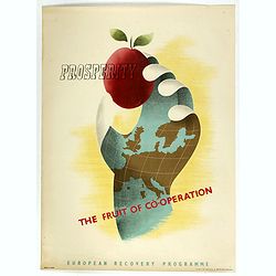
Prosperity - The Fruit of Cooperation.
NATO poster for European Cooperation by Brian E. Dear. On the poster the slogan "Prosperity the fruit of cooperation". The poster is showing a hand holding an a...
Place & Date: Kühn & Zoon Rotterdam, 1950
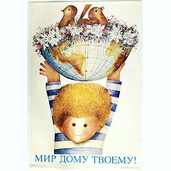
Protect the globe!, 1989.
USSR propaganda poster, with the slogan "protect de globe". A child holding a globe with flowers and birds.
Place & Date: Russia, 1989
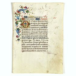
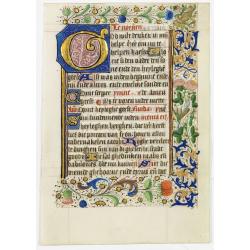
Leaf on vellum from an Italian manuscript Book of Hours.
A leaf from an Italian Book of Hours, written on vellum in the neighborhood of Ferrara, around 1480.The decorations of this leaf are extraordinary : the bouquet of flower...
Place & Date: Italy, Ferrara, ca.1480

COLLECTION OF HONG KONG MAPS, BOOKS & FLYERS. Including CHINA - HONGKONG surveyed by Captn. Sir Edward Belcher, in H.M.S. Sulphur 1841. Corrected to 1901.
A collection of 30 maps, prints, and publications relating to Hong Kong. Including : - BELCHER, E. Sir, An updated version of this most important nautical chart of Hong K...
Place & Date: London, 1841 - 1901

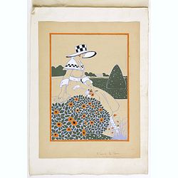
(Art déco gouache)
Outstanding "art deco" gouache (unsigned) from the workshop of "Robert Pichon. Ateliers de Dessin et Lithographie – 10, rue Rochechouart – Paris. The g...
Place & Date: Paris, ca. 1930
(Art déco gouache)
Outstanding "art deco" gouache (unsigned) from the workshop of "Robert Pichon. Ateliers de Dessin et Lithographie – 10, rue Rochechouart – Paris. The g...
Place & Date: Paris, ca. 1930

(Art déco gouache)
Outstanding "art deco" gouache (unsigned) from the workshop of "Robert Pichon. Ateliers de Dessin et Lithographie – 10, rue Rochechouart – Paris. The g...
Place & Date: Paris, ca. 1930
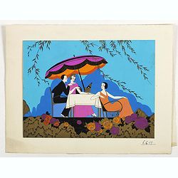
(Art-déco gouache)
Outstanding "art deco" gouache (unsigned) from the workshop of "Robert Pichon. Ateliers de Dessin et Lithographie – 10, rue Rochechouart – Paris. The g...
Place & Date: Paris, ca. 1930
(Art-déco gouache)
Outstanding "art deco" gouache (unsigned) from the workshop of "Robert Pichon. Ateliers de Dessin et Lithographie – 10, rue Rochechouart – Paris. The g...
Place & Date: Paris, ca. 1930

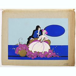
(Art déco gouache with winter scene of The Palace of Westminster )
Outstanding "art deco" gouache (unsigned) from the workshop of "Robert Pichon. Ateliers de Dessin et Lithographie – 10, rue Rochechouart – Paris. The ...
Place & Date: Paris, ca. 1930

Carte des Trois Arabies. Tiree en Partie de l'Arabe de Nubie, en Partie de Divers autres Autheurs. . .
Rare map of the Arabian Peninsula, first published in 1654 and one of the first large maps focused specifically on the Arabian Peninsula. Sanson's map of the Arabian Peni...
Place & Date: Paris, 1654

Vue et description des principales villes de l'Armenie et de la Georgie avec les habillements des femmes du pays, et ceux des prêtres et religieux armeniens. . .Tom: V N° 11 Pag: 28
View and description of the principal Armenian and Georgian cities with illustrations of Armenian women's garments as well as priests' and monks' clothing. The views are ...
Place & Date: Amsterdam, ca 1720

Le Théâtre du monde dédié au roi contenant les cartes générales et particulières des royaumes et états qui le composent.
The present example of the Théâtre du monde is the reissue of 1746 by Jean-Baptiste Nolin II. This scarce atlas is illustrated with 123 maps mostly double-page, in orig...
Place & Date: Paris, 1746

Excelsiori (Rana N. 28 - Cent. 20).
"After so many wars and so many troubles, young Russia, in a more serene glaze all the beautiful sun of freedom you will enjoy ... ". Fascinating allegorical sa...
Place & Date: Bologna, 1905

Nova et Accuratissima Totius Terrarum Orbis Tabula.
Since its appearance as an Appendix in 1630, the atlas launched by Willem Blaeu and continued by his son Joan had expanded greatly. But despite many new regional maps the...
Place & Date: Amsterdam, 1662
![[Il mondo a pezzi - Europa].](/uploads/cache/42849-250x250.jpg)
[Il mondo a pezzi - Europa].
Satirical representation of the division of the world by the main European powers. At the center of the scene a globe on which is written "MONDO Maledeto Interesse ...
Place & Date: Bologna, 1690

Mer de Chine - Detroit De Singapour Partie Comprise Entre Singaour et Le Dett. De Malacca d'apres les travaux du Commr. J.W. Reed de la Marine Royale d'Angleterr, ...
A detailed chart of Singapore Strait, drawn from an English Chart by J.W. Reed, who surveyed Singapore and environs between 1865 and 1869, aboard the H.M.S. Rifleman.The ...
Place & Date: Paris, 1873
![[Map of Palestine ]](/uploads/cache/42176-250x250.jpg)
[Map of Palestine ]
Map of Palestine from "La Mer des Hystoires" published by Dupré, Paris, 1536 "La Mer des Hystoires" is a translation into French of the famous "...
Place & Date: Dupre, Paris, 1536

Carte d'unne partie de l'Arabie Septentrionale Pour suivre les Voyages de Mr. G.A. Vallin. . .
This is the original hand-drawn map by Victor Adolphe Malte-Brun of "Carte d'unne partie de l'Arabie Septentrionale Pour suivre les Voyages de Mr. G.A. Wallin",...
Place & Date: Paris, November 1855
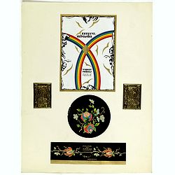
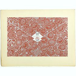
Five Art déco labels.
5 Lithographed perfume labels laid on original cardboard sheet. A striking example of commercial artworks produced by the artist and graphic designer Robert Pichon and hi...
Place & Date: Paris, between 1925 and 1930
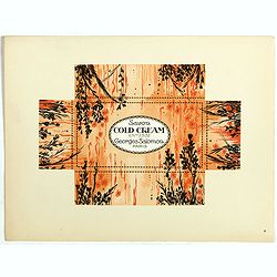
Art déco label for Georges Salomon Paris.
Lithographed perfume label "Savon Cold cream N°1531 - Georges Salomon Paris" laid on original cardboard sheet. A striking example of commercial artworks produc...
Place & Date: Paris, between 1925 and 1930
Art déco label Biette Savon - Tein de fleur.
Lithographed perfume label " Biette Savon - Tein de fleur" laid on original cardboard sheet. A striking example of commercial artworks produced by the artist an...
Place & Date: Paris, between 1925 and 1930
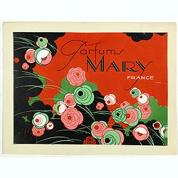
Art déco label for Parfum Mary France.
Lithographed perfume label "Parfum Mary France" laid on original cardboard sheet. A striking example of commercial artworks produced by the artist and graphic d...
Place & Date: Paris, between 1925 and 1930
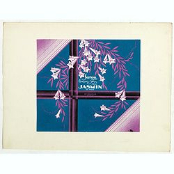
Art déco label for de Neuville, Paris.
Lithographed perfume label " Savon extra fin au jasmin N°1727 " laid on original cardboard sheet. A striking example of commercial artworks produced by the art...
Place & Date: Paris, between 1925 and 1930
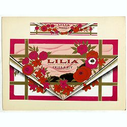
Art déco label Paul Tranoy, Paris.
Lithographed perfume label " Lilia Savon extra fin soap - Œillet (carnation) Paul Tranoy Paris N°725 " laid on original cardboard sheet. A striking example of...
Place & Date: Paris, between 1925 and 1930

La nuova Zelanda delineate sulle ultima osservazioni del Capitan Cook.
First edition on laid paper Cassini’s splendid early map of New Zealand, being the most decorative version of Captain Cook's map of New Zealand, published in the very s...
Place & Date: Rome, 1798

L'Arabia delineata sulle ultime osservazioni.
First edition on laid paper. Cassini’s splendid early map of Arabia.
Place & Date: Rome, 1797

A Map of the British Empire in AMERICA with the French, Spanish and Hollandish Settlements Adjacent Thereto. by Henry Popple. / Nouvelle Carte Particuliere de L'Amerique . . .
The four sheet Dutch edition of Popple's monumental map of North America, in mint condition. Encompassing the West Indies, Florida, Louisiana, Texas and Central America.T...
Place & Date: Amsterdam, ca. 1737
Leaf on vellum, from a manuscript book of hours.
Scatter border of flowers. Borders of very high quality, executed by an artist of the Ghent-Bruges school.VERSO: 19 lines of Dutch text in brown ink. A 6-lines capital &q...
Place & Date: Flanders, 1450

Pascaerte vande Caribische Eylanden, vande Barbados tot aende Bocht van Mexico ‘t Amsterdam By Hendrick Doncker. . .
First state. Rare. “This chart appeared in the first edition of Hendrick Doncker’s Zee-Atlas, of which no surviving example is known” -- Burden. This is an example ...
Place & Date: Amsterdam, 1659

Manoeuvres executées du 7 au 13 mai sous le Commandement du général Koeltz,par le XIXe Corps d'Armée. . .
Poster by Gaston Ry [aka René Rostagny] (1902-1978) showing the allied manouvers in Tunesia. On May 4, 1943, the nineteenth CA offensive drew most of the German tanks to...
Place & Date: Alger, Bacconnier, 1943
![[Magazine including pictorial world map, Carriers of the New Black Plague by William Cotton.]](/uploads/cache/43680-250x250.jpg)
[Magazine including pictorial world map, Carriers of the New Black Plague by William Cotton.]
Front cover with color illustration of Moroccan male sheik and yellow lettering.Oversized magazine, features analysis of English justice, map of Herr Hitler's heaven (ful...
Place & Date: Chicago, April 7th, Vol.1 No.1 1938
Het Groote Tafereel der Dwaasheid, vertoonende de opkomst, voortgang en ondergang der Actie, Bubbel en Windnegotie, in Vrankryk, Engeland, en de Nederlanden, gespleegt in den Jaare MDCCXX...
AN EARLY ISSUE of this biting and vulgar satire on the Mississippi and South Sea Bubbles and an extraordinary visual record with 78 plates of the first banking crash, sho...
Place & Date: Amsterdam, 1720

Asiae Minoris nova descriptio. Geographische Beschryvinge aller Landen... ende sendbrieuen der Apostele...
Extremely rare map from a Dutch bible, published by Dancker Danckerts. This map was included in a Dutch bible including several maps signed by C.Danckerts and one dated 1...
Place & Date: Amsterdam, 1643

Calendrier de la cour, tiré des éphémérides, pour l'Année bissextile.. / Notebook bearing silver plates with the VOC monogram.
A personal gift, only made for the trustees of the V.O.C. The silver plate was probably made by Drick van Hengel and Company because an entry in the diary of mintmaster J...
Place & Date: Paris, 1787

La Pieuvre Germanique.
Scarce lithographed plate not dated, by Eugène Danzanvilliers, printed by Grandremy in Paris. The plate listed by Adhemar is dated 1874. Eugène Danzanvilliers was a dra...
Place & Date: Paris, 28 Quai de la Rapée, c.1874

Tweevoudigh onderwiis van de Hemelsche en Aerdsche Globen; Het een Na de meyning van Ptolemeus met een vasten Aerdkloot...
Tweevoudigh onderwiis van de Hemelsche en Aerdsche Globen; Het een Na de meyning van Ptolemeus met een vasten Aerdkloot; Het ander Na de Natuerlijcke stelling van N. Cope...
Place & Date: Amsterdam, 1655

Atlas Universel de Géographie. Sixième partie - Océanique.
Volume 6 including detailed maps of Australia, New Zealand, Hawaii, Pacific islands, Indonesia and 3 maps of the Philippines. With title page and one general map.Supporte...
Place & Date: Brussels 1827

Waere affbeeldinge wegens het casteel ende stadt Batavia.
A good impression of this finely engraved and detailed plan of Batavia, present-day Jakarta, the Dutch center of trading activities in the East Indies. Copied after Cleme...
Place & Date: Amsterdam, 1681

Tafel der Lender darin der Apostel Paulus geprediget hat.
Rare wood block map depicting the Mediterranean, with an over-sized Cyprus from the final Dutch edition of Heinrich Bünting's famous Itinerarium Sacrae Scripturae, a boo...
Place & Date: Magdeburg, 1581

Nieuwe en Nette Afteekening van het Eyland Corsica en het Eyland Elba vertoonende alle desselfs Havenen, Steeden en Rivieren . . .
Highly decorative large sea chart of Corsica, Sardinia and Elba, including multiple sailing ships, compass roses, cartouche, coat of arms, rhumb lines, topographical deta...
Place & Date: Amsterdam, ca. 1710

L'Homme A La Boule.
Satirical print in which Count Otto von Bismarck balances on the world with one spurred foot entering France, and wearing only his underpants which are marked with the Ge...
Place & Date: Paris, 1870-1871

Daniae regni typum . . .
Second Edition, now for the first time with a date (1630), this rare map which - like that of Janssonius-Kaerius - is based on John Speed's map of 1626. The side borders ...
Place & Date: Amsterdam, 1630
![Province de Fo-Kien. [Includes West Coast of Taiwan]](/uploads/cache/43503-250x250.jpg)
Province de Fo-Kien. [Includes West Coast of Taiwan]
Important map of Fujian Province, showing the east coast of China and the west coast of Taiwan. It shows that for the Manchu Qing, only the western half of Formosa was co...
Place & Date: The Hague, H. Scheurleer, 1737

Cunard to Canada.
Poster by Charles Eddowes Turner for Cunard lines. The poster shows The NEW SYLVANIA, one of the four new 22,000 - ton Cunarders which are the largest ever built for serv...
Place & Date: England, ca. 1930
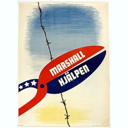
Marshall Hjälpen.
Marshall Plan poster made by Gusta Aberg, showing barbed wire cut by pliers with slogan on pliers: Marshall Hjälpen This is one of the 25 finalists in the 1950 “Intra-...
Place & Date: Kühn & Zoon Rotterdam, 1950

Nova XVII Provinciarum Inferioris Germaniae descriptio .
Extremely rare map of the Benelux by Frederick de Widt. Originally engraved and published by P.Kaerius in 1607. In 1662 the plate came in the possession of Frederick de W...
Place & Date: Amsterdam, 1662

Mapa geogra´fico de la mayor parte de la Ame´rica Meridional que contiene los paises por donde debe trazarse la li´nia divisoria que divida los dominios de Espan~a y Portugal. . .
Rare first edition of the map drawn by Francisco Requena (1743-1824) after his expedition to the Amazon in order to delineate the boundary between the Spanish and Portugu...
Place & Date: Bourquin, F. Philadelphia, ca. 1876
![Le Sacre Hagard [Haggard-falcon]](/uploads/cache/44315-250x250.jpg)
Le Sacre Hagard [Haggard-falcon]
A beautiful elephant folio sized colored lithograph of a Hagard Falcon, taken from the famous book on Falconry Traite de Fauconnerie by Schlegel and A.H. Verster van Wulv...
Place & Date: Leiden, 1844-1853
![[Manuscript chart on vellum of the Java Sea]](/uploads/cache/33613-250x250.jpg)
[Manuscript chart on vellum of the Java Sea]
One of the few manuscript charts on vellum in private hands, signed by Isaac de Graaf. ORIGINAL MANUSCRIPT MAP IN RED, GREEN AND BLACK INK showing the Java Sea centered o...
Place & Date: Amsterdam, 1743

Frisia occidentalis.
A rare separately published carte-a-figures of Friesland by Geelkercken in its first state. The title and the coats of arms of the eleven Frisian towns appear in the cent...
Place & Date: [Leeuwarden], Dierick Albertsen, 1618

Belgii sive Germaniae Inferioris accuratissima tabula.
Very rare and very decorative map with in the right and left borders costumed figures and town plans alternately. In top and bottom border town plans and views.Separate p...
Place & Date: Amsterdam, 1631

Amstelodamum, Celebre Emporium Forma Plana.
Second state of this rare and decorative plan of Amsterdam with Visscher's imprint. With a panoramic view seen from the IJ and further insets of Council House, The Exchan...
Place & Date: Amsterdam, c. 1636

Composite atlas of the Low Countries.
A composite atlas comprising 18 double-page engraved maps by or after Hessel Gerritsz, Theodoor Galle, Jacob van Deventer, Gerard Mercator, Peter Verbiest, Jean Surhon, C...
Place & Date: [Antwerp, c. 1633

Naaukeurige Platte Grond van den Staat en den Loop van Rio de Berbice Met derzelver Plantagien in de Geoctrojeerde Colonie de Berbice Gelegen. . .
Uncommon large-scale map of Berbice with Rio de Berbice and Rio de Canjewith at the bottom left a list of plantation owners. In top 3 x 3 coats of arms in cartouches. The...
Place & Date: Amsterdam, 1742

Original copperplate.
Showing the coast of southern Morocco, the Sahara with the Canary Islands. Copperplates that had been used in the production of early maps are of the greatest rarity and ...
Place & Date: Amsterdam, ca. 1660

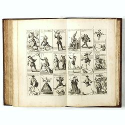
Habiti delle Donne Venetiane . . .
Title page of the book Habiti delle Donne Venetiane" (Dress of Venetian Women) which consists of twenty numbered plates of ornately dressed women. This very decorati...
Place & Date: Venice, ca. 1591

Mercurius.
Mercury holding a caduceus and riding in a chariot drawn by two birds on the clouds in the sky, an extensive landscape with a harbor with goods being loaded and unloaded ...
Place & Date: Antwerp, 1585

Lapis polaris magnes.
This is a plate from a series of twenty prints illustrating new inventions and discoveries (Nova Reperta) after Jan van der Straet. On image, bottom right: 'Ion. Stradanu...
Place & Date: Antwerp, Philips Galle, c. 1590

Histoire Socialiste.
Text includes “Imp. Centre de Propagande, des Républicains Nationaux, 102, rue Amelot, Paris (XIe), ou l’on peut se procurer cette affiche. Cette affiche ne peut êt...
Place & Date: Paris, 1931

Comitatus Flandria.
A highly decorative map with in the left and right top corners the pictures of archduke Albert of Austria and Isabella, queen of Spain. In the left and right borders cost...
Place & Date: Amsterdam, 1648

Nova Germaniae Descriptio..
A finely engraved carte à figures, with the side borders depicting emperors, while the upper and lower panels contain finely engraved miniature town prospects, among the...
Place & Date: Amsterdam, 1632

Ignographia candiae tertia a turcis obsessae in lucem edita a F. de Wit.
A scarce broadsheet plan and view of Heraklion on one sheet: prospect 180 x 495mm, map 395 x 495mm., in the lower part a printed description "Abbildung der starken S...
Place & Date: Amsterdam, 1680

Trop d'Appetit par A. Le Petit.
Dated in lower right dated "Le 9 juin 1875". The drawing is representing an alligator's jaw wearing a Prussian helmet, and about to chew a globe. Alfred Le Peti...
Place & Date: Paris, 1875
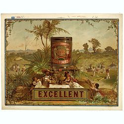
Café des gourmands E. Guittard - Excellent.
Original chromo lithographed coffee advertising poster by Gonthier-Dreyfus & Co., for E. Guittard & Co. The company was started by Eddy Guittard, who emigrated fr...
Place & Date: Paris, ca. 1880
Selling price: $380
Sold in 2023
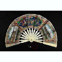
A fan combines views of Hong Kong (right), Canton (left), China, ca 1850-1860.
The fan shows nice images of Hong Kong and Canton on onside and on verso a garden with 39 characters welcoming a rider on his white horse. Their clothes are heightened in...
Place & Date: China, ca. 1850-1860

Lutetia Furens. Das ist : Die wütende Statt PARIS.
Rarissime placard dirigé contre la Ligue et le duc de Mayenne. La gravure est signée I.S. (marque inconnue). Ce placard en latin et en allemand est une reprise de l’e...
Place & Date: France ca.. 1594
![Jules Verne Le Tour du Monde en 80 jours. [Goose game board inspired by Jules Verne's novel Tour du Monde en 80 jours.]](/uploads/cache/44919-250x250.jpg)
Jules Verne Le Tour du Monde en 80 jours. [Goose game board inspired by Jules Verne's novel Tour du Monde en 80 jours.]
Goose game board inspired by Jules Verne's novel, whose boxes are illustrated with color lithographs and the center occupied by a world map. Vignette illustrations number...
Place & Date: Paris, ca. 1880

Paskaerte Zynde t'Oosterdeel Van Oost Indien, met alle de Eylanden daer ontrendt geleegen van C. Comorin tota aen Iapan.
An eye-catching chart of Pieter Goos' sea chart of Australia, Southeast Asia, China, Japan, Korea and India. The chart shows the regions from Cape Comorin (Southern India...
Place & Date: Amsterdam, 1669
![Candia [Map of the island Crete]](/uploads/cache/45233-250x250.jpg)
Candia [Map of the island Crete]
Very rare map of the island Crete published in the first edition of "Viaggio da Venetia, a Costantinopoli. Per Mare, e per Terra, & infieme quello di Terra Santa...
Place & Date: Venice, Giacomo Franco, 1598

Jerusalem.
Very rare view of Jerusalem published in the first edition of "Viaggio da Venetia, a Costantinopoli. Per Mare, e per Terra, & infieme quello di Terra Santa. Da G...
Place & Date: Venice, Giacomo Franco, 1598
![[World and 4 continents] Carte Geographique Astronomique Chronologique et Historique du Monde.](/uploads/cache/63024-250x250.jpg)
[World and 4 continents] Carte Geographique Astronomique Chronologique et Historique du Monde.
French wall map of the world in 4 sheets published by Crépy "à l'entrée du Cloistre de St. Benoist du côté des maturins". A decorative wall map of the worl...
Place & Date: Paris, 1720-1735