Browse Listings

EUROP, and the cheife Cities contayned therin described. . .
A good impression from an early edition of this famous and decorative "carte à figures"- map from the first world atlas produced by an Englishman - John Speed'...
Place & Date: London, 1627 - 1676

(Totius Americae nova et exacta tabula ex) optimis tum geographorum tum aliorum scriptis collecta et ad hodiernam regnorum principatuum et maiorum partium distinctionem accomodata.
Eastern part of a two-sheet map of America, with attribution to Willem Blaeu. According to Philip Burden, the map was derived from Cornelius Danckert's 1647 map of the sa...
Place & Date: Rome, 1679

Nova Orbis Tabula in Lucem edita A.F.de Wit.
According to Shirley, De Wit's map is one of the most attractive of its time. The brilliant scenes in the corners combine images of the four seasons, the elements, and th...
Place & Date: Amsterdam, 1680

Nova Totius Terrarum Orbis Geographica ac Hydrographica Tabula.
A beautifully decorative world map taken from the 'English Atlas' by Moses Pitt and Steven Swart, based on an earlier engraved world map by Pieter van den Keere ca. 1630,...
Place & Date: Oxford, 1680

Pas-kaart vande Zee kusten van Venecuela met de Byleggende Eylanden. . .
Rare chart of the coast of Venezuela, including the islands of Curaçao, Bonaire, Aruba, etc.The chart has two insets, one (15x22cm) with a map of Curaçao, one smaller w...
Place & Date: Amsterdam, 1680

Ignographia candiae tertia a turcis obsessae in lucem edita a F. de Wit.
A scarce broadsheet plan and view of Heraklion on one sheet: prospect 180 x 495mm, map 395 x 495mm., in the lower part a printed description "Abbildung der starken S...
Place & Date: Amsterdam, 1680
-250x250.jpg)
Hern Johann Baptisten Taveniers..Vierzig Jaehrige Reize..
This German edition includes Tavernier's map of Japan in a reduced form (210x315mm) and contains legends about the country's nature, e.g., where gold is mined and plottin...
Place & Date: Nuremberg, 1681

Waere affbeeldinge wegens het casteel ende stadt Batavia.
A good impression of this finely engraved and detailed plan of Batavia, present-day Jakarta, the Dutch center of trading activities in the East Indies. Copied after Cleme...
Place & Date: Amsterdam, 1681

Jerusalem.
Engraved by Bastiaan Stoopendaal from Juan Bautista Villapando's imaginary town-plan of Jerusalem. This bird's-eye view is surrounded by 12 scenes, views and portraits of...
Place & Date: Amsterdam, 1682

Het Beloofde Landt Canaan door wandelt . . .
A beautifully engraved map of the ancient land of Canaan which roughly corresponds to present-day Israel. Cherubs hold up a draped cloth of key symbols, also a scale pane...
Place & Date: Amsterdam, 1682

Il regno della China detto presentente Catay e Magnin. . .
A rare and decorative Italian map of China and Japan, with Japan closely modelled on the indented Cardim outline and Hokkaido, called Yuppi , shown as an Asian peninsula....
Place & Date: Rome, 1682

Archipelague du Mexique ou sont les Isles de Cuba..
Scarce map of Caribbean. A visually stunning map with a large title cartouche. This large one-sheet map was produced by the Venetian cosmographer Vincenzo Coronelli when ...
Place & Date: Paris, 1688

Carte du Palatinat du Rhin.
Decorative "carte à figures"- map centered on Koblenz, Metz, Strasburg, Manheim and Heidelberg, with the river Rhine by François Jollain (ca. 1641 – 18 Apri...
Place & Date: Paris, ca. 1688

Isola di Madagascar o di S. Lorenzo Scoperta dà Portoghesi nell anno 1506. . .
Decorative and highly detailed map of Madagascar, including 2 decorative cartouches and other embellishments.The remarkable Vincenzo Coronelli (1650-1718), was a Francisc...
Place & Date: Venice, 1690

Saique batiment dont les turcs se servent. . .
A very decorative engraving of a Turkish vessel. From Mortier's famous maritime Atlas "Neptune François". Engraved by Jan van Vianen after a design by Henri Sb...
Place & Date: Amsterdam, 1690
![[Il mondo a pezzi - Europa].](/uploads/cache/42849-250x250.jpg)
[Il mondo a pezzi - Europa].
Satirical representation of the division of the world by the main European powers. At the center of the scene a globe on which is written "MONDO Maledeto Interesse ...
Place & Date: Bologna, 1690

Les vallées du Piemont. Habitees par les Vaudois ou Berbets. . .
Detailed map of Piedmont region covering French and Italian territories. Surrounded by a French text description "Description des vallées du Piemont qu'habitent par...
Place & Date: Paris, 1690

L'Africa divisa nelle sue Parti secondo le pui moderne . . .
A beautiful and rare two-sheet map of Africa. The title cartouche is depicted on a drape surrounded by native animals.A most noticeable feature of the decoration on the m...
Place & Date: Venice, 1690

Le comte de Namur et partie des Duchez de Brabant. . .
Decorative map centered on Namen and including the towns of Liege, Leuven, Charleroi, Dinant, Luxemburg, etc. by François Jollain (ca. 1641 – 18 April 1704).Rare "...
Place & Date: Paris, c. 1692
![Amerique Septentrionale divisée en ses principales parties. . .1692. [California as an Island]](/uploads/cache/27961-250x250.jpg)
Amerique Septentrionale divisée en ses principales parties. . .1692. [California as an Island]
A very good impression of Jaillot's large map of North America, showing California as an Island, based upon Sanson's landmark map of 1656. A first state.The map shows the...
Place & Date: Amsterdam, c.1692

Het gezandtschap der Neerlandtsche Oost-Indische Compagnie, aan den grooten Tartarischen Cham, Den tegenwoordigen Keizer van China. . .
Third edition of this beautifully illustrated work on China. The first edition was published in 1665.Jan Nieuhof was a "Dutch traveler and adventurer" (1618-72)...
Place & Date: Amsterdam, W. Waasberge, 1693

Belgii novi, angliae novae, et partis Virginiae . . .
This example is state 3 of the original Janssonius plate, printed after Schenk acquired the plates at public auction in 1694 from the heirs of Jansson van Waesberge. The ...
Place & Date: Amsterdam, 1694

Hamburgum.
Engraved bird's-eye town-plan of Hamburg, two keys below. Frederick de Wit published after 1694 a town book of European and Asian cities (Theatrum Praecipuarum Totius Eur...
Place & Date: Amsterdam, ca. 1694

Parte orientale della China.. / Parte occidentale della China. (2 sheets)
The map depicts the eastern part of China with Korea -correctly- as a peninsula. Formosa is included as well. Japan is partly visible i.e. the area of Yamaguchi, strait K...
Place & Date: Venice, 1695

Vaisseau du premier rang portant pavillon d'amiral.
Fine double-page engraved plate of a naval vessel, with the various parts of the ship numbered and identified. From Mortier's "Neptune François". From Mortier'...
Place & Date: Amsterdam, 1695

Marcomania hoggidi Merchesato de Moravia. . .
Although Komensky's map of Moravia was already known in his time, Coronelli used the obsolete map by Fabricius, with a lot of locations added by the publisher's unchained...
Place & Date: Venice, 1696

Parte settentrionale dell' Irlanda / Irlanda parte meridionale . . .
A beautiful and flamboyantly engraved grand two-sheet map of Ireland. Embellished with two cartouches, a vessel under sail and a sea monster.The map is the product of the...
Place & Date: Venice, 1696

Ducatus Prussiae tam Polono Regiae. . .
This is a rare issue of Frederick de Wit's attractive map of the northern part of Poland, Prussia and the Baltic regions.Very decorative title cartouche, including three ...
Place & Date: Amsterdam, 1698

Venise. 1700
Extremely rare panoramic broad sheet panoramic town-view of Venice with underneath in letter press a description of the town's history. The view measures more than 1 mete...
Place & Date: Paris, 1699

Launa vulgo Laun Bohemiae civitas.
Bird's-eye views of Louny in Bohemia by G. Hoefnagel. The copperplate was made for Braun and Hogenberg's town book. However there the print has been transformed by the en...
Place & Date: The Hague, 1700

Chorographia Terrae Sanctae in Angustiorem. . .
Rare. Large visually rich map decorated with illustrations of the sacred objects and places of Judaism. In the bottom center is a plan of ancient Jerusalem, and the route...
Place & Date: Amsterdam, ca. 1700
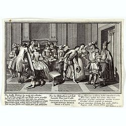
Sanitati et Voluptati inservientes herbae thee et caffe.
Copper-plate engraving showing a group of fashionably dressed men and women, drinking tea or coffee. "Paulus Decker inv. et del.; Ioh. Christoph Steudner sculp.; Mar...
Place & Date: Augsburg, 1700

Tschopau.
Very decorative and rare panoramic of Tschopau.The engraver and publisher of prints, Mrs. Anna Beek of the Hague, enlarged the print and mounted it on larger paper: she ...
Place & Date: The Hague, ca. 1700

Carta geographica generalatus carlostatuensiscum adgacentibus confinis turcicis et venetis...
Fine and rare manuscript map of Croatia and the Dalmatian coast from the early eighteenth century. Oriented to the south the map details the Venetian, Austrian and Turkis...
Place & Date: Venice ?, c. 1700

Schlanium vulgo Schlani Bohemiae oppidum.
Very decorative and rare panoramic town view of Schlan, Schlanium s. Slany.The engraver and publisher of prints, Mrs. Anna Beek of the Hague, enlarged this print, origina...
Place & Date: The Hague, 1700

Volna.
Very decorative and rare panoramic town-view of Volna. We have more Anna Beek prints available.The engraver and publisher of prints, Mrs. Anna Beek of the Hague, enlarg...
Place & Date: The Hague, ca. 1700

Het Friessche Doolhoff, het beruchte dorp Molk-Worren
Uncommon map made in 1718 by Johannes Hilarides, principal at the Latin School in Bolsward.. Probably the only printed plan of a Frisian village of that time. The map was...
Place & Date: Amsterdam, 1705

Horizon ring for globe.
Printed horizon ring for a 28cm diameter German globe. The ring is divided in quarters and engraved two by two on one copper plate. The size of the paper is 44 x 33cm. Th...
Place & Date: Nuremberg, 1704/1705

La mer Mediterranee divisee en ses principales parties ou mers. . .
Very large map centered on the Mediterranean. With a sub title along upper margin "La Mer Mediterranée divisée en Mer de Levant et de Ponant Subdivisées en Leurs ...
Place & Date: Amsterdam, c.1705

LA RUSSIE NOIRE ou POLONOISE qui Comprend les PROVINCES DE LA RUSSIE NOIRE de VOLHYNIE et de PODOLIE divisées en leurs Palatinats Vulgairement Connües sous le Nom D'VKRAINE ou PAYS DES COSAQUES.
Very rare map of the Ukraine and Poland, prepared by Sanson in 1675 in a third state, published by the heirs of Sanson, in Paris in 1706. The imprint changed to: Par les ...
Place & Date: Paris, 1706