Search Listings matching "ukraine" in Europe > Russia / Baltic / Black Sea region

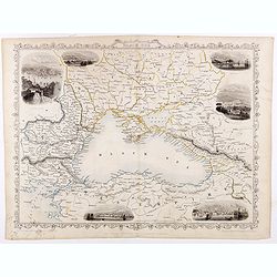
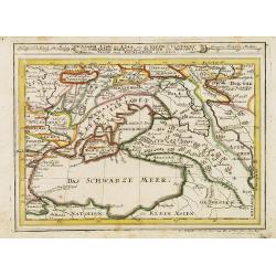
Black Sea.
Decorative steel engraved map of the Black Sea with inset views of Sebastopol and Odessa. There are also vignettes of Constantinople, Sinope and Varna. Taken from "T...
- $90 / ≈ €84
Place & Date: London, London Printing and publishing Company of London, ca. 1851
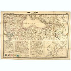
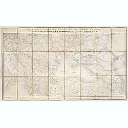
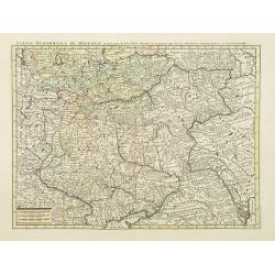
Carte d'Orient par Kraminski ingénieur.
Large map of Orient, with an insert of four maps (Constantinople plan - Map of Europe - Map of Russia - Plan of Baltic sea). With flags in the lower left part. color key ...
Place & Date: Paris, 1854
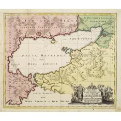
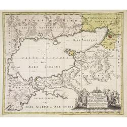
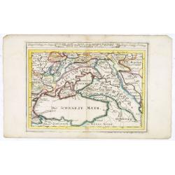
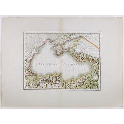
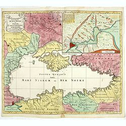
Maris Assoviensis vel de Zabache et Paludis Maeotidis. . .
A very detailed map showing the Black Sea, Azow and Rostow area.
Place & Date: Augsburg, 1720
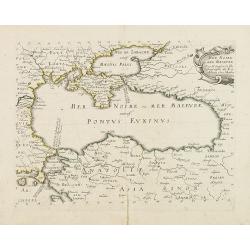
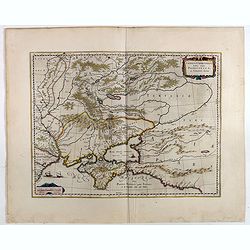
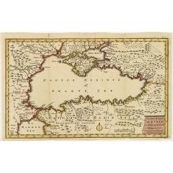
Mer Noire ou Mer Maievre, . . .
Map of the Black Sea prepared by N.Sanson and published by Pierre Mariette.Published in an early edition of the small Sanson atlas L'Europe Dediée a Monseigneur . . . Le...
Place & Date: Paris, P. Mariette, 1667
Il Turkestan il Mar d'Aral ed il Mar Caspio.
Uncommon map of Turkestan with the Northern part of the Caspian Sea, prepared by Francesco Costantino Marmocchi. Above the map "Geografia Commerciale". From &qu...
Place & Date: Genova, Paolo Rivara fu Giacomo, 1858
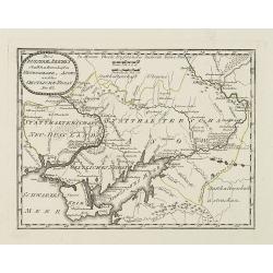
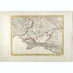
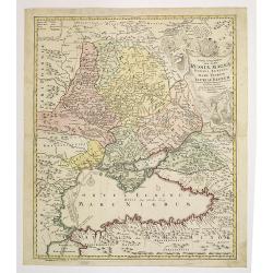
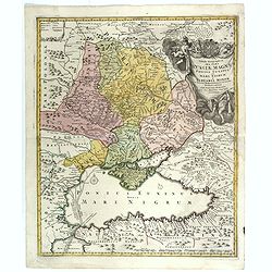
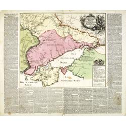
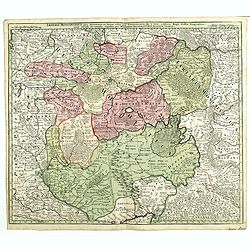
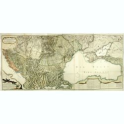
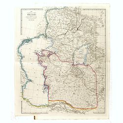
Des Russischen Reiches Statthalterschaften Neurussland, Asow, und das Oestliche Nogay
Map showing Lake Asow and the Crimea. The river Dnepr until Krementschug, and the river Don until Pawlowsk. Published by Franz Johann Joseph von Reilly.
Place & Date: Vienna, 1789
Taurica Chersonesus, Nostra aetate Przecopsca, et Gazara dicitur.
Part of Russia with in the north Smolensk and Moscow and in the south the Black Sea.As Willem Blaeu died in 1638 most of his maps are actually published by his son Joan. ...
Place & Date: Amsterdam, 1638
![[Costume plate of Grebenski Cossacks in the Caucasus]](/uploads/cache/62339-250x250.jpg)
[Costume plate of Grebenski Cossacks in the Caucasus]
Aquatint costume plate of Grebenski Cossacks in the Caucasus. Plate N° 10. From Giulio Ferrario's work Le Costume ancien et moderne ou histoire du gouvernement, de la mi...
Place & Date: Milan, 1827
![[Costumes des Karabulaks - Caucase]](/uploads/cache/62344-250x250.jpg)
[Costumes des Karabulaks - Caucase]
Four men from the Caucasus in typical dress from the Karabulaks tribe. Plate N° 15. from Giulio Ferrario's work "Le Costume Ancien et Moderne ou Histoire du gouvern...
Place & Date: Milan, 1827
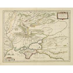
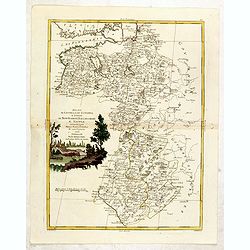
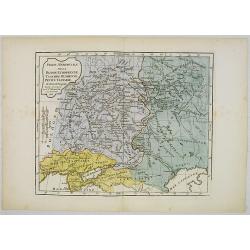
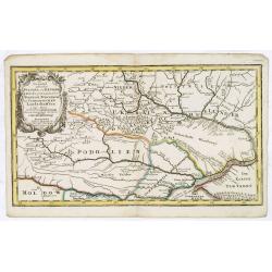
Partie méridionale de la Russie Européenne. . .
Detailed map of Ukraine and the Crimea. In lower right corner inset map of Cosaques. From his "Atlas Universel".Gilles Robert de Vaugondy (1688–1766), also kn...
Place & Date: Paris, 1752
Geographica Nova ex Oriente gratiosissima, duabus tabulis specialissimis contenta, quarum una Mare Caspium..
Map of the Caspian Sea and the peninsula of Kamchatka (Jedso) in northeast Asia on one sheet.Separated by an attractive panel with figurative title cartouche, cherubs, an...
Place & Date: Nuremberg, 1730
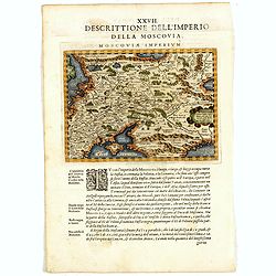
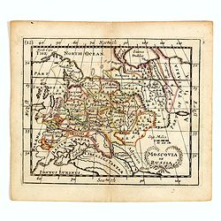
Descrittione Dell'Imperio della MOSCOVIA IMPERIUM.
Uncommon map including Latvia, Livonia, Lithuania, the Ukraine, and northern Part of the Black Sea and the Caspian Sea, Siberia, Georgia, Azerbaijan, Kazakhstan.Giovanni ...
Place & Date: Venice, 1596
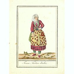
Femme Tartare d'Usbec.
Originally hand-colored costume mezzotint of a woman from Uzbekistan engraved by Félix Mixelle and Lachaussée Jeune after Jacques Grasset de Saint-Sauveur.As an etcher,...
Place & Date: Paris,1801-1806
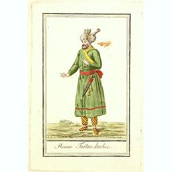
Homme Tartare d'Usbec.
Originally hand-colored costume mezzotint of a man from Uzbekistan engraved by Félix Mixelle and Lachaussée Jeune after Jacques Grasset de Saint-Sauveur.As an etcher, d...
Place & Date: Paris,1801-1806
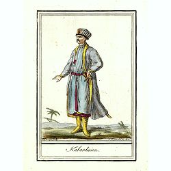
Kabardinien.
Originally hand-colored costume mezzotint of a Kabardian from the Northwest Caucasus, engraved by Félix Mixelle and Lachaussée Jeune after Jacques Grasset de Saint-Sauv...
Place & Date: Paris,1801-1806
Kriegstheater oder Graenzkarte Oesterreichs, Russlands, und der Türkey. . .
Map of the theatre of war in the Balkans, Ukraine and around the Black Sea, indicating the Austrian, Russian and Turkish spheres of influence. Printed on two sheets and j...
Place & Date: Artaria und Compagnie, Vienna, 1788
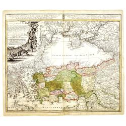
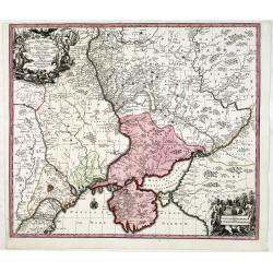
La Crimée, la nouvelle Russie, les Tatares Nugay et d'Oczakow...
Engraved by Perrier, Bourgoin and Arrivet. The map was prepared by the Venetian cartographer and publisher François (Père) Santini and first published in Santini's &quo...
Place & Date: Venice, 1784
Selling price: $110
Sold in 2015
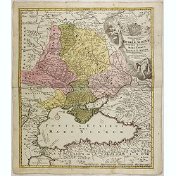
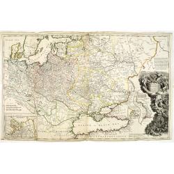
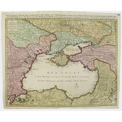
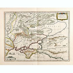
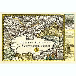
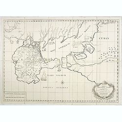
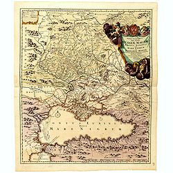
Tabula Geographica qua pars Russiae Magnae Pontus Euxinus seu mare Nigrum et Tartaria Minor cum finitimis Bulgariae, et Romaniae et Natoliae. . .
Homann's map is based upon Beauplan's general map of Ukraine but depicts the political changes of the preceding years. Shows Constantinople. Extends north to Moscow and S...
- $700 / ≈ €655
Place & Date: Nuremburg, 1750
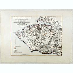
Accampamenti, Trinceramenti, ed Operazioni di Assedio...
Detailed plan of the Allied siege of Sebastopol in 1854-1855 during the Crimean War, showing the allied French, English and Turkish positions, and those of the Russians, ...
- $400 / ≈ €374
Place & Date: Naples, 1855
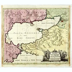
Maris Assoviensis vel de Zabache et Paludis Maeotidis. . .
A very detailed map showing the Black Sea, Azow and Rostow area. With a decorative allegorical cartouche, showing the costumes of the indigenous people of the region.
- $900 / ≈ €842
Place & Date: Augsburg, 1720
Nova Mappa Geographica Maris Assoviensis Vel De Zabache Et Paludis Maeotidis accurate aeri incis et in luce edita . . .
Striking map of the Sea of Azov with adjacent countries and the Strait of Kerch, with a decorative allegorical cartouche, showing the costumes of the indigenous people of...
- $400 / ≈ €374
Place & Date: Augsburg, 1730
Ducati di Livonia e di Estonia, e Governi di Nowogorod...
Shows today's Estonia, and the governorates Nowgorod, Bialgorod and Kiew in today's Russia, Belarus and Ukraine.
- $175 / ≈ €164
Place & Date: Venise, 1782
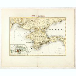
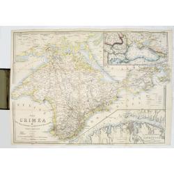
Carte de la Crimée / dressée par A. Vuillemin.
Attractive map of Crimea with inset plan of Sevastopol, prepared by Alexandre Aimé Vuillemin (1812-1886). A road system and the ferry lines are drawn in.Engraved by Jaco...
- $300 / ≈ €281
Place & Date: Paris, ca. 1860
Tabula Geographica qua pars Russiae Magnae. . .
U unrecorded state Homann's map is based upon the works of George von Mengden (1628-1702), a Livonian cartographer who worked for Peter the Great and Count Jacob Bruce [G...
- $1000 / ≈ €936
Place & Date: Nuremberg, c. 1770
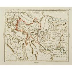
Carte de L'Asie Mineure ou de la Natolie et du Pont Euxin
Johann Baptist Homann's well-engraved map of Asia Minor, the Black Sea ( Ponti Euxin), Crimea and a part of Greece. Depicts Turkey and the area surrounding the Black Sea ...
- $500 / ≈ €468
Place & Date: Nuremberg, ca. 1748
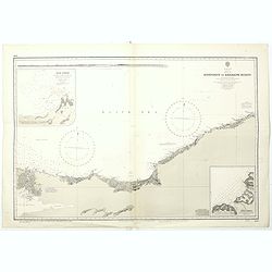
Black sea - Sheet IX - Bosporus to Kerempe Burnu . . .
A highly corrected version of Admiralty chart 2238 originally published 16th June 1854. Edition Date 1980.Detailed chart of Bosporus. With prohibited landing places in pu...
- $100 / ≈ €94
Place & Date: London, 1854-1980
Illyricum Orientis In quo Partes II. Moesia et Thracia. Provinciae XI.
Attractive historical map of the area west of the Black Sea, today's Bulgaria, Rumania, etc. Based on the cartography of Nicolas Sanson and published by Covens and Mortie...
- $400 / ≈ €374
Place & Date: Amsterdam, c. 1720
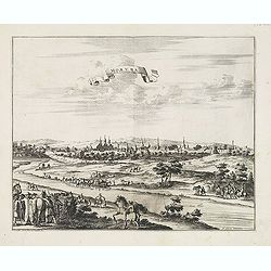
Moruma ville de la Tartarie Moscovite.
Decorative view of the town of Moruma, Russian city near the northern shore of the Caspian sea as seen from across the river Oka. This well executed engraving was publish...
- $300 / ≈ €281
Place & Date: Leiden, 1719-1727
Tabula Geographica qua pars Russiae Magnae. . .
Homann's map is based upon Beauplan's general map of Ukraine but depicts the political changes of the preceding years. With decorative cartouches. Giving good detail alon...
- $680 / ≈ €636
Place & Date: Nuremberg, 1720
Taurica Chersonesus, Nostra aetate Prezecopsca, et Gazara dicitur.
Part of Russia with in the north Smolensk and including Moscow and in the south the Black Sea.More about Willem Blaeu. [+]Taurica, Tauric Chersonese, and Taurida were nam...
- $500 / ≈ €468
Place & Date: Amsterdam, 1645
Carte de la Crimée.
Fine map of Crimea (Ukraine) here in the only issue of this version of Bellin's map, slightly larger than the common version. From Bellin's Le Petit Atlas Maritime Recuei...
- $175 / ≈ €164
Place & Date: Paris, 1764
Charte der Kriegs Operationen am Donn u: Dnieper Ihro Russisch Kayserl Majestaet Glorieusen Armeen A: 1736.
Very rare separately published map of the southern part of Ukraine, with an explanatory key A-N in the lower right. The map is surrounded by letterpress German text givin...
- $900 / ≈ €842
Place & Date: Augsburg, 1750
To His Most Serene and August Majesty Peter Alexovitz Absolute Lord of Russia &c. This map of Moscovy, Poland, Little Tartary, and ye Black Sea &c. is most Humbly Dedicated by H. Moll Geographer
Magnificent large-scale, English map of Russia, Ukraine, Poland, Finland and the Baltic Countries and extending south to the Black Sea and the Balkans, with an ornate ded...
- $1500 / ≈ €1404
Place & Date: London, 1716
Ukrania quae et Terra Cosaccorum. . .
Homann's map is based upon Beauplan's general map of Ukraine but depicts the political changes of the preceding years. The cartouche portrays Hetman Mazepa with his follo...
- $1750 / ≈ €1638
Place & Date: Nuremberg, 1720
Plan général des environs de Sébastopol avec indication de la disposition générale de l'armée alliée au 24 octobre / 5 novembre 1854 et du mouvement du prince Gortchakow vers le mont Sapoune.
A very rare panoramic town-plan of the siege of Sebastopol. In lower margin : "Gravé au Dépôt topographique de la Guerre". From "Défense de Sébastopol...
Place & Date: Saint-Pétersbourg / Paris, 1863-1874
Selling price: $750
Sold in 2014
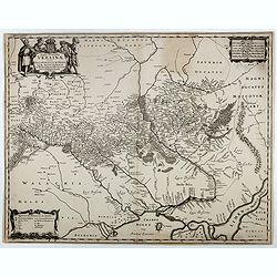
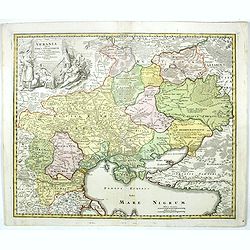
Typus Generalis Ukrainae sive Palatinatuum Podoliae, Kioviensis et Braczlaviensis terras nova delineatione exhibens. . .
A key map engraved by Johannes Janssonius in about 1656 and based on Guillaume La Vasseur de Beauplan's map of the region published in "Description d'Ukraine". ...
- $2000 / ≈ €1871
Place & Date: Amsterdam, ca. 1657
Alexandri Magni Imperium et Expeditio per Africam et potissimum per Aslam.
Rare map of the Empire of Alexander the Great, prepared by J.B.Nolin and published by Monhare for his Atlas Général a l'usage des colleges et maisons d'education.. Cent...
- $300 / ≈ €281
Place & Date: Paris, 1783
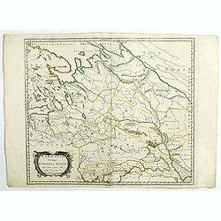
Partie Méridionale de la Russie Européenne, Tartarie, Russienne, Petite Tartarie.
Map of the southern part of Russia and Tartary. By C. F. Delamarche, successor of Robert de Vaugondy, Geographer.
- $90 / ≈ €84
Place & Date: Paris, 1806
Nouvelle Carte de la Petite Tartarie et la Mer Noire, montrant les Frontieres de l'Impératrice de Russie et de l'Empereur des Turcs, tant en Europe qu'en Asie, Dessigné selon la proposition de G. De L'Isle et d'autres Auteurs.
The Ukraine and the Black Sea in a fine impression with original 18th-c. hand-coloring.
- $1250 / ≈ €1170
Place & Date: Amsterdam, 1730

Nova Maris Caspii et Regions Usbeck..
A detailed map of part of Russia, Central Asia centered on the Caspian, Uzbek territory to the east of the Caspian and northern Persia. A finely engraved, uncolored title...
Place & Date: Nuremberg, 1735
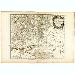
![[2 maps and one text sheet] Theatrum Belli A° MDCCXXXVII. . . / Verus Chersonesi Tauricae Seu Crimea Conspectus adjacentium item Regionem itinerisq ab Exercitu Ruthemo...](/uploads/cache/27975-250x250.jpg)
[2 maps and one text sheet] Theatrum Belli A° MDCCXXXVII. . . / Verus Chersonesi Tauricae Seu Crimea Conspectus adjacentium item Regionem itinerisq ab Exercitu Ruthemo...
[2 maps and one text sheet] Theatrum Belli A° MDCCXXXVII. . . / Verus Chersonesi Tauricae Seu Crimea Conspectus adjacentium item Regionem itinerisq ab Exercitu Ruthemo A...
- $1100 / ≈ €1029
Place & Date: Amsterdam, c. 1744
Vera Delineatio Provinciae Fertilissimae Kilan olim Hyrcaniae ad Mare Caspium Sitae.
Uncommon map prepared by Adam Olearius showing the region of Azerbaijan and Iran. The map is oriented with north to the upper left corner and adorned with an attractive t...
- $400 / ≈ €374
Place & Date: Jean Dupuis in Paris, 1659
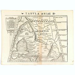
Tabula Asiae II (Black Sea and Caspian Sea).
The first edition of Münster's map of Ukraine and the region north of the Black Sea, based upon Claudius Ptolemy which appeared in his "Geographia Universalis"...
- $400 / ≈ €374
Place & Date: Basel, Heinrich Petri, 1545
An exact map of the CRIM (Formely Taurica Chersonesus) Part of Lesser Tartary, the Sea of Asoph, and the adjacent Country of the Kuban Tartars. . .
Detailed and handsome wood block printed map centered on the Sea of Azov detailing the ongoing war between the Russians and Turks. The map is filled troop locations and b...
Place & Date: London, 1739
Selling price: $200
Sold in 2010
![[Calmucchi].](/uploads/cache/34988-250x250.jpg)
[Calmucchi].
Aquatint costume plate of the Kalmyk people. The name is given to the Oirats in Russia, whose ancestors migrated from Dzungaria in 1607. They created the Kalmyk Khanate i...
- $50 / ≈ €47
Place & Date: Milan, 1827
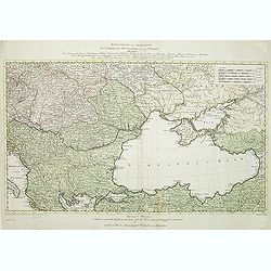
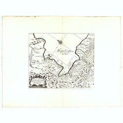
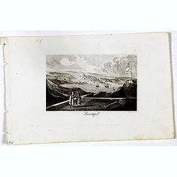
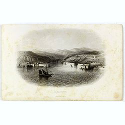
Black Sea.
Decorative steel engraved map of the Black Sea with inset views of Sebastopol and Odessa. There are also vignettes of Constantinople, Sinope and Varna. Taken from "T...
- $110 / ≈ €103
Place & Date: London, London Printing and publishing Company of London, ca. 1851
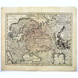
Sarmatia utraque europaea et asiatica. . .
Ancient map of the European part of Russia with the Ukraine. Dated 1654.Nicolas Sanson was to bring about the rise of French cartography, although the fierce competition ...
- $300 / ≈ €281
Place & Date: Paris, 1654
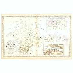
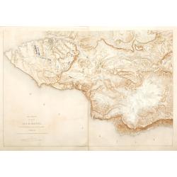
A Complete Map of the Crimea Showing the Military and Carriage Roads with Distances from Various Points of the Western Coast From English & Russian Surveys. . .
Uncommon map of Crimea with (inset maps) Sebastopol Harbor, and Map Showing the relative Position of the Crimea with the Seat of War. From Desilver's "A New Universa...
- $300 / ≈ €281
Place & Date: Pennsylvania, ca. 1856
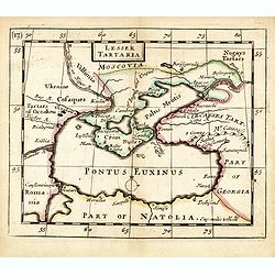
Lesser Tartaria.
A late seventeenth-century English map of the Crimea and southern Ukraine, with the whole of the Black Sea and its shores. A scarce little map utilized in various of the ...
- $300 / ≈ €281
Place & Date: London, 1685
Taurica Chersonesus, Nostra aetate Przecopsca, et Gazara dicitur.
Detailed map of the Ukraine, Russia with in the north Smolensk and Moscow and in the south the Black Sea. Shows ports, fortified cities and the mouths of the Danube. Mino...
- $750 / ≈ €702
Place & Date: Amsterdam, 1645
Imperii Moscovitici pars Australis.
A detailed map of the region around Moscow. Including the Ukraine and Cossack regions, to the west is Russian Poland and Lithuania, to the east Russian Tartary and Siberi...
- $500 / ≈ €468
Place & Date: Augsburg, 1730
Assoph, Asow, oder Azak mit der Kleinen Tartarey dem Scwharzen Meer. . .
Scarce map showing the Black Sea region with Southern Ukraine, Georgia and Armenia.
- $300 / ≈ €281
Place & Date: Augsburg, 1715
Die Gegend Zwischen Pultava und Bender Mitt Angraenzenden Polnisch, Turckisch und Tartarischen Landschafften.
Scarce map showing central part of the Ukraine with Bjelaja-Zerkow, Poltawa between the Dniester and Dnieper rivers. Black Sea in lower right corner. Detailed with notes,...
- $300 / ≈ €281
Place & Date: Augsburg, 1715
Black Sea.
Decorative steel engraved map of the Black Sea with inset views of Sebastopol and Odessa. There are also vignettes of Constantinople, Sinope and Varna. Taken from "T...
- $90 / ≈ €84
Place & Date: London, London Printing and publishing Company of London, ca. 1851
The Crimea by James Wyld Geographer to the Queen & H.R.H. Prince Albert.
The second edition of this folding map of Crimea. In the upper right corner, an inset map of the areas around the Black Sea, "The Town & Harbor of Sevastopol wit...
Place & Date: London, 1854
Selling price: $250
Sold in 2017
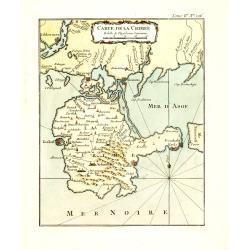
Carte de la Mer Noire ou Kara Degniz.
Original antique copper engraved map of the Black Sea with attractive original hand coloring.
- $200 / ≈ €187
Place & Date: Paris, 1791-1801
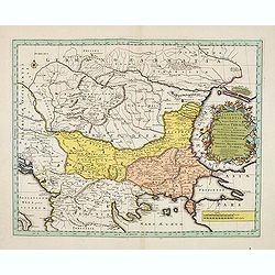
Die Europaeische oder kleine Tartarey, nebst den angraentzenden Laendern. . .
Showing the Black Sea region. Uncommon map from the "Atlas Selectus" by the German cartographer Johann Georg Schreiber (1676-1750). Schreiber followed in the fo...
- $450 / ≈ €421
Place & Date: Leipzig, 1741
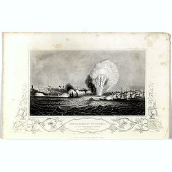
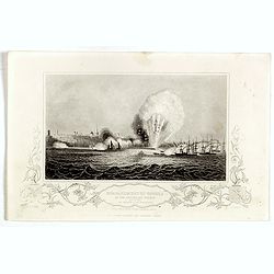
Bombardment of Odessa by the English and French April 22 1854, explosion on the imperial mole . . .
Scene from the Crimea war, showing a bombardment of Odessa, 22nd April 1854 (during Crimean War, 1853-56), by English and French forces, explosion imperial mole (breakwat...
- $30 / ≈ €28
Place & Date: London, 1855
Sewastopol. (Sebastopol)
View of Sebastopol. Engraved by Leopold Zechmayer who was active in Vienna.
- $20 / ≈ €19
Place & Date: Vienna, ca. 1835
Carte pour suivre la marche de la guerre en Orient, dressée d'après les ordres de l'empereur: par L. Sagansan.
Detailed folding map of the theatre of war in the Balkans, Ukraine and around the Black Sea, indicating the Austrian, Russian and Turkish spheres of influence, prepared b...
Place & Date: Paris, ca. 1854
Selling price: $50
Sold in 2019
Moscoviae seu Russiae Magnae Generalis Tabula. . .
A scarce and attractive, wide-ranging map of incorporating Scandinavia, the Baltic countries, parts of Germany and Czechoslovakia, Poland, Hungary, Ukraine, Bulgaria, Nor...
- $1500 / ≈ €1404
Place & Date: Augsburg, 1740
Geographische General Karte Der Gränzen zwischen denen dreyen Kaiserthümern und ihren nach und nach geschehenen Veränderungen vom Jahr 1718 bis heutigen Tags. . .
Detailed map of present-day Bulgaria, which is carved into the Ottoman provinces of Bulgaria, Macedonia, and Romania (Rumelia), the Crimea and the Black Sea. Prepared by ...
- $1250 / ≈ €1170
Place & Date: Vienna, 1788-1789
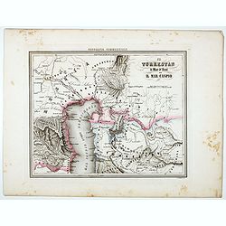
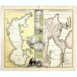
The Caspian sea Khivah and the surrounding country
Map of Ukraine published by John Arrowsmith (1790-1873) in his "The London Atlas of Universal Geography, Exhibiting the Physical & Political Divisions of the Var...
- $450 / ≈ €421
Place & Date: London, 2-1846
Theatrum belli Russorum Victoriis illustratum sive Nova et accurata Turcicarum et Tartaricum. . .
Uncommon and decorative map of Ukraine, showing the theatre of the Russo-Turkish War in the Ukraine in 1735-1739. The map gives detailed information of the fortifications...
- $1250 / ≈ €1170
Place & Date: Nuremberg, ca. 1757
Verus Chersonesi Tauricae Seu Crimea Conspectus adjacentium item Regionem itinerisq ab Exercitu Ruthemo Ao MDCCXXXVI et MDCCXXXVII adversus Tattaros Susceptis . . .
Map of the environs of the Crimea, showing the route of the Russian Army in its expedition against the Tartars in 1736 and 1737. Showing detailed movements, including enc...
Place & Date: St Petersburg, Academy of Sciences, 1740
Selling price: $700
Sold in 2015

Nouveau théâtre de la guerre entre les Russes les turcs et les polonois confédérés.
A very rare separately published map of Crime region. With a large title cartouche lower left "Nouveau theâtre de la guerre entre les russes, les turcs et les polon...
- $2000 / ≈ €1871
Place & Date: Paris, 1769
![[Schwarzes Meer] Nr 1](/uploads/cache/37946-250x250.jpg)
[Schwarzes Meer] Nr 1
Uncommon map of the Black Sea and Crimea. In lower part a scale. Prepared by Friedrich Handtke (1815-1879). Map set in a decorative border.
- $120 / ≈ €112
Place & Date: Glogau, Leipzig, 1877
Bombardment of Odessa by the English and French April 22 1854, explosion on the imperial mole . . .
Scene from the Crimea war, showing a bombardment of Odessa, 22nd April 1854 (during Crimean War, 1853-56), by English and French forces, explosion imperial mole (breakwat...
- $30 / ≈ €28
Place & Date: London, ca. 1879
Moscovia or Russia
A rare late seventeenth-century English map of Russia and the Crimea and southern Ukraine, with the northern coast of the Black Sea and its shores. A scarce little map ut...
- $300 / ≈ €281
Place & Date: London, 1685
Tabula Geographica qua pars Russiae Magnae Pontus Euxinus seu Mare Nigrum et Tartaria Minor.
Homann's map is based upon the works of George von Mengden (1628-1702) a Livonian cartographer who worked for Peter the Great and Count Jacob Bruce [Graf Jakov Villimovic...
- $750 / ≈ €702
Place & Date: Nuremburg, after 1750
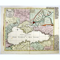
Nova Mappa Maris Nigris et Freti Constantinopolitani...
Map of the Black Sea with the Crimea and adjacent countries, inset map of the Bosporus with Constantinople at upper right.T.C. Lotter married M. Seutter's daughter in 174...
- $600 / ≈ €561
Place & Date: Augsburg, ca. 1760
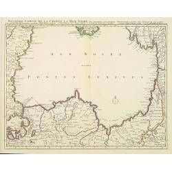
Seconde partie de la Crimee la Mer Noire. . .
The lower part of a set of two maps from the observations of Guillaume Delisle focusing on the Black Sea with wonderful detail of the surrounding regions. Includes Consta...
- $750 / ≈ €702
Place & Date: Amsterdam, 1720
Sebastopol.
Steel engraving of the harbour at Sebastopol in the Ukraine published by James Virtue around 1860.
- $45 / ≈ €42
Place & Date: London, 1860
Taurica Chersonesus.
One of the earliest detailed maps of the Crimea and Ukraine between the northern coast of the Black Sea and Moscow.With the engraved signature of Gerard Mercator in lower...
- $300 / ≈ €281
Place & Date: Amsterdam, 1639-1644
Russia in Europe Part VIII with index map.
Very detailed steel engraved map of the region north of the Black Sea, Podolia, Bessarabia, Kherson, Iekaterinoslav, Taurida, Krimea. Relief shown by hachures.The map is ...
- $150 / ≈ €140
Place & Date: London, Edward Stanford, 1864
Nieuwe kaart van de Crim de Zwarte Zee en omleggende. . .
Showing the Black Sea and the Marmara Sea with Istanbul. Published in the rare first edition of Kleyne en Beknopte Atlas, of Tooneel des Oorlogs in Europa...The atlas wa...
Place & Date: Amsterdam, 1735
Selling price: $450
Sold in 2013
Assoph, Asow, oder Azak mit der Kleinen Tartarey dem Scwharzen Meer. . .
Scarce map showing the Black Sea region with Southern Ukraine, Georgia and Armenia.
- $100 / ≈ €94
Place & Date: Augsburg, 1715
Partie Meridionale de Moscovie. . .
Scarce map centered on Moscow including Azow and part of present-day Ukraine in the bottom part of the map. The map is based on Delisle's important map of the region with...
- $750 / ≈ €702
Place & Date: Amsterdam, 1720
Nova Mappa Maris Nigri et Freti Constantino Politani. . .
Decorative and uncommon map the Black Sea region. In upper left hand corner an inset map (200 x 280mm) of the Bosporus including Istanbul. Title engraved onto a drape-sty...
- $450 / ≈ €421
Place & Date: Augsburg, ca. 1760
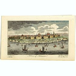
A View of Astracan. (Astrakhan)
A striking and highly detailed copper engraved panoramic view of Astrakhan, Russia, with its buildings, churches and town wall. The River Volga in the foreground. Several...
- $50 / ≈ €47
Place & Date: London, 1820