Search Listings matching "cyprus" in Asia
![.[Near east with Cyprus]](/uploads/cache/33857-250x250.jpg)
.[Near east with Cyprus]
Wood block printed map and one of earliest printed representation of Near east with Cyprus prepared by Martin Waldseemüller. Based on the slightly larger map from 1513 p...
Place & Date: Vienna, 1525 -1541
![[Map of Turkey]](/uploads/cache/31502-250x250.jpg)
[Map of Turkey]
Page with an early representation of Turkey with Cyprus and Syria. This text page with a fine wood block printed map is from the rare work "C. Iulii Solini Polyhisto...
- $275 / ≈ €257
Place & Date: Basle, Michael Isengrin, 1544

Tabula Asiae IIII. (Cyprus, Holy Land, Syria, Jordan, Iraq)
Gastaldi's map showing Cyprus, the Holy Land, Syria, Jordan and Iraq, based upon Ptolemy's map It is one of the earliest obtainable maps of the region.From Giacomo Gastal...
- $350 / ≈ €328
Place & Date: Venice, 1548
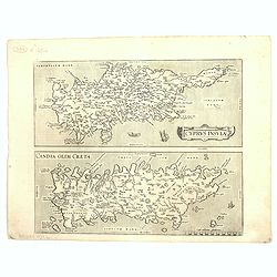
Cyprus Insula / Candia, Olim Creta.
Two maps on one sheet. Copper engraving illustrating Cyprus and Crete, with Latin text on verso. From 1584 onwards editions of the Ortelius atlas no longer included this ...
Place & Date: Antwerp, 1575
![[Map of the Holy Land, including Cyprus]](/uploads/cache/33436-250x250.jpg)
[Map of the Holy Land, including Cyprus]
Attractive full page longitudinal map of Palestine, Syria and Cyprus, cut by Hans Rudolf Manuel Deutsch. The shore line running from Southern Anatolia to the Nile Delta. ...
Place & Date: Basle, 1550-1580

Tafel der Lender darin der Apostel Paulus geprediget hat.
Rare wood block map depicting the Mediterranean, with an over-sized Cyprus from the final Dutch edition of Heinrich Bünting's famous Itinerarium Sacrae Scripturae, a boo...
Place & Date: Magdeburg, 1581
![[Asia Minor]](/uploads/cache/35958-250x250.jpg)
[Asia Minor]
Early, attractive woodcut map of Turkey, with Cyprus shown in the lower right corner. On the full sheet with German text beneath and verso. From the German edition of Seb...
- $50 / ≈ €47
Place & Date: Basle, 1584
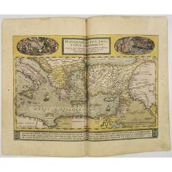
Peregrinationis Divi Pauli Typus..
A splendid map depicting the travels of Paulus. With two fine scenes in top. Showing the countries along the Mediterranean, including Cyprus and Italy. A first edition wi...
- $1500 / ≈ €1404
Place & Date: Antwerp, 1584

Natoliae.. Aegypti recentior.. Carthaginis ( 3 maps on 1 sheet)
Three maps on one sheet. Map to the left east to the top. Detailed map Turkey, including Cyprus and Crete. Also map of the Nile delta and another map of Tunis. From "...
- $750 / ≈ €702
Place & Date: Antwerp, 1587
![[De terra sancta.]](/uploads/cache/32540-250x250.jpg)
[De terra sancta.]
On verso a map of the Middle East with Syria, Israel and Cyprus (123x158mm.). From a Latin text edition of his Geographia , that great compendium of Renaissance knowledge...
- $50 / ≈ €47
Place & Date: Basle, 1550-1590