Search Listings matching "cyprus"
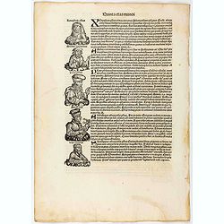
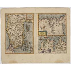
Quita Etas Mundi. Folium.LXXIII
The Latin text page is illustrated with a depictions of Kings, Noble men and women and scientists. RECTO : Including a portrait of Zeno, an Attic philosopher from Cyprus....
- $150 / ≈ €140
Place & Date: Nuremberg, 12 July 1493
![Terta Etas Mundi. Foliu CX [With view of Metz]](/uploads/cache/46260-250x250.jpg)
Terta Etas Mundi. Foliu CX [With view of Metz]
The Latin text page is illustrated with a depictions of Kings, Noble men and women and scientists, among Eustace (Eustachius) a Roman soldier and martyr, appears as a bea...
- $450 / ≈ €421
Place & Date: Nuremberg, 12 July 1493
![.[Near east with Cyprus]](/uploads/cache/33857-250x250.jpg)
.[Near east with Cyprus]
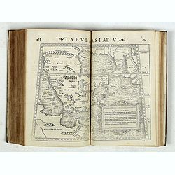
Wood block printed map and one of earliest printed representation of Near east with Cyprus prepared by Martin Waldseemüller. Based on the slightly larger map from 1513 p...
Place & Date: Vienna, 1525 -1541
![[Map of Turkey]](/uploads/cache/31502-250x250.jpg)
[Map of Turkey]
Page with an early representation of Turkey with Cyprus and Syria. This text page with a fine wood block printed map is from the rare work "C. Iulii Solini Polyhisto...
- $275 / ≈ €257
Place & Date: Basle, Michael Isengrin, 1544

Tabula Asiae IIII. (Cyprus, Holy Land, Syria, Jordan, Iraq)
Gastaldi's map showing Cyprus, the Holy Land, Syria, Jordan and Iraq, based upon Ptolemy's map It is one of the earliest obtainable maps of the region.From Giacomo Gastal...
- $350 / ≈ €328
Place & Date: Venice, 1548
Strabonis nobilissimi et doctissimi philosophi ac geographi Rervm geographicarum commentarij libris XVII contenti, Latini facti Gvilielmo Xylandro Augustano interprete. . .
A few marginal annotations (pp. 109-111), in a 19th c. hand. Latin translation with a commentary by Wilhelm Holtzmann, also called Guglielmus Xylander. (1532-1576), libra...
- $15000 / ≈ €14036
Place & Date: Basle, Henri Petri, 1571
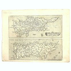
Cyprus Insula / Candia, Olim Creta.
Two maps on one sheet. Copper engraving illustrating Cyprus and Crete, with Latin text on verso. From 1584 onwards editions of the Ortelius atlas no longer included this ...
Place & Date: Antwerp, 1575
![[Map of the Holy Land, including Cyprus]](/uploads/cache/33436-250x250.jpg)
[Map of the Holy Land, including Cyprus]
Attractive full page longitudinal map of Palestine, Syria and Cyprus, cut by Hans Rudolf Manuel Deutsch. The shore line running from Southern Anatolia to the Nile Delta. ...
Place & Date: Basle, 1550-1580

Tafel der Lender darin der Apostel Paulus geprediget hat.
Rare wood block map depicting the Mediterranean, with an over-sized Cyprus from the final Dutch edition of Heinrich Bünting's famous Itinerarium Sacrae Scripturae, a boo...
Place & Date: Magdeburg, 1581
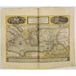
Peregrinationis Divi Pauli Typus..
A splendid map depicting the travels of Paulus. With two fine scenes in top. Showing the countries along the Mediterranean, including Cyprus and Italy. A first edition wi...
- $1500 / ≈ €1404
Place & Date: Antwerp, 1584
![[Asia Minor]](/uploads/cache/35958-250x250.jpg)
[Asia Minor]
Early, attractive woodcut map of Turkey, with Cyprus shown in the lower right corner. On the full sheet with German text beneath and verso. From the German edition of Seb...
- $50 / ≈ €47
Place & Date: Basle, 1584

Natoliae.. Aegypti recentior.. Carthaginis ( 3 maps on 1 sheet)
Three maps on one sheet. Map to the left east to the top. Detailed map Turkey, including Cyprus and Crete. Also map of the Nile delta and another map of Tunis. From "...
- $750 / ≈ €702
Place & Date: Antwerp, 1587
![[De terra sancta.]](/uploads/cache/32540-250x250.jpg)
[De terra sancta.]
On verso a map of the Middle East with Syria, Israel and Cyprus (123x158mm.). From a Latin text edition of his Geographia , that great compendium of Renaissance knowledge...
- $50 / ≈ €47
Place & Date: Basle, 1550-1590

Peregrinationis Divi Pauli Typus corographicus. . .
A splendid map depicting the travels of Paulus. With two fine scenes in top. Showing the countries along the Mediterranean, including Cyprus and Italy. A first edition wi...
Place & Date: Antwerp, 1595
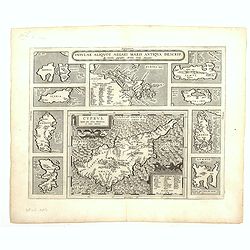
Cyprus - Insular Aliquot Aegaei maris antiqua descrip.
Ten maps on one sheet. With large map of Cyprus. Provenance: This map is from the personal collection of dr. Marcel van den Broecke, author of Ortelius Atlas Maps An...
Place & Date: Antwerp, 1595
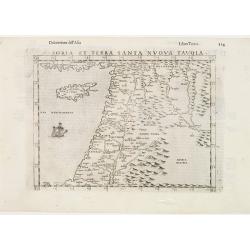
Soria et Terra Santa nuova tavola.
Early map of this classical map of the Holy Land, including Cyprus, prepared by Giovanni Botero. The copper plate was however later used by Giuseppe Rosaccio's expended e...
- $500 / ≈ €468
Place & Date: Venice, 1598
Natoliae Quae Olim Asia Minor, Nova de Scriptio / Carthaginis Celeberrimi Sinus Typus / Aegypti re Centior de Scriptio
Three detailed regional maps by Ortelius from his "Theatrum Orbis Terrarum", the world's first modern atlas.The first map covers Asia Minor, Cyprus and the East...
Place & Date: Antwerp, 1598
![Venetia. [Venice ]](/uploads/cache/45176-250x250.jpg)
Venetia. [Venice ]
Very rare view of Venice published in the first edition of "Viaggio da Venetia, a Costantinopoli. Per Mare, e per Terra, & infieme quello di Terra Santa. Da Gios...
Place & Date: Venice, Giacomo Franco, 1598
![[ Map of the island Nexos]](/uploads/cache/45289-250x250.jpg)
[ Map of the island Nexos]
Very rare map of the island Naxos published in the first edition of "Viaggio da Venetia, a Costantinopoli. Per Mare, e per Terra, & infieme quello di Terra Santa...
Place & Date: Venice, Giacomo Franco, 1598
![[View of Caorle].](/uploads/cache/45190-250x250.jpg)
[View of Caorle].
Very rare view of Caorle, at the time an island, published in the first edition of "Viaggio da Venetia, a Costantinopoli. Per Mare, e per Terra, & infieme quello...
Place & Date: Venice, Giacomo Franco, 1598
![[View of Gulf of Trieste].](/uploads/cache/45191-250x250.jpg)
[View of Gulf of Trieste].
Very rare view of Gulf of Trieste published in the first edition of "Viaggio da Venetia, a Costantinopoli. Per Mare, e per Terra, & infieme quello di Terra Santa...
Place & Date: Venice, Giacomo Franco, 1598
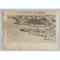
Polla Querrner [Pula in southern Istria)
Very rare view of Pula in southern Istria, published in the first edition of "Viaggio da Venetia, a Costantinopoli. Per Mare, e per Terra, & infieme quello di Te...
Place & Date: Venice, Giacomo Franco, 1598
![[San Nicola, Tremiti islands, in Italy. ]](/uploads/cache/45204-250x250.jpg)
[San Nicola, Tremiti islands, in Italy. ]
Very rare view of San Nicola, Tremiti islands, in Italy, published in the first edition of "Viaggio da Venetia, a Costantinopoli. Per Mare, e per Terra, & infiem...
Place & Date: Venice, Giacomo Franco, 1598
![[ View of Cruzola]](/uploads/cache/45205-250x250.jpg)
[ View of Cruzola]
Very rare view of Tremite Islands Island published in the first edition of "Viaggio da Venetia, a Costantinopoli. Per Mare, e per Terra, & infieme quello di Terr...
Place & Date: Venice, Giacomo Franco, 1598
![[ View of Ragusi]](/uploads/cache/45206-250x250.jpg)
[ View of Ragusi]
Very rare view of Ragusa published in the first edition of "Viaggio da Venetia, a Costantinopoli. Per Mare, e per Terra, & infieme quello di Terra Santa. Da Gios...
Place & Date: Venice, Giacomo Franco, 1598
![Scutari [View of Shkodër - Albania]](/uploads/cache/45213-250x250.jpg)
Scutari [View of Shkodër - Albania]
Very rare view of Shkodër or Shkodra, historically known as Scutari or Scodra, is a city in the Republic of Albania. It is the capital of the surrounding county of Shkod...
Place & Date: Venice, Giacomo Franco, 1598
![Antivari [View of Bar in Montenegro]](/uploads/cache/45214-250x250.jpg)
Antivari [View of Bar in Montenegro]
Very rare view of Bar in Montenegro published in the first edition of "Viaggio da Venetia, a Costantinopoli. Per Mare, e per Terra, & infieme quello di Terra San...
Place & Date: Venice, Giacomo Franco, 1598
![Valona [ View of Valona]](/uploads/cache/45215-250x250.jpg)
Valona [ View of Valona]
Very rare view of Vlora in Albania published in the first edition of "Viaggio da Venetia, a Costantinopoli. Per Mare, e per Terra, & infieme quello di Terra Sant...
Place & Date: Venice, Giacomo Franco, 1598
![Fortezza Di Sopoto [Fortress of Sopot in Abania]](/uploads/cache/45216-250x250.jpg)
Fortezza Di Sopoto [Fortress of Sopot in Abania]
Very rare view of the Fortress of Sopot in Albania published in the first edition of "Viaggio da Venetia, a Costantinopoli. Per Mare, e per Terra, & infieme quel...
Place & Date: Venice, Giacomo Franco, 1598
![Sopoto - Margaritino. [Sopot and Margarita in Albania]](/uploads/cache/45218-250x250.jpg)
Sopoto - Margaritino. [Sopot and Margarita in Albania]
Very rare view of Sopot and Margarita in Albania published in the first edition of "Viaggio da Venetia, a Costantinopoli. Per Mare, e per Terra, & infieme quello...
Place & Date: Venice, Giacomo Franco, 1598
![[Map of Corfu. View of the city of Corfu on the foreground. ]](/uploads/cache/45221-250x250.jpg)
[Map of Corfu. View of the city of Corfu on the foreground. ]
Very rare map of Corfu with a view of the city of Corfu on the foreground. Published in the first edition of "Viaggio da Venetia, a Costantinopoli. Per Mare, e per T...
Place & Date: Venice, Giacomo Franco, 1598
![Zafalonia [Map of Kefalonia]](/uploads/cache/45223-250x250.jpg)
Zafalonia [Map of Kefalonia]
Very rare map of the island of Kefalonia published in the first edition of "Viaggio da Venetia, a Costantinopoli. Per Mare, e per Terra, & infieme quello di Terr...
- $450 / ≈ €421
Place & Date: Venice, Giacomo Franco, 1598
![[Map of Zakynthos or Zante]](/uploads/cache/45226-250x250.jpg)
[Map of Zakynthos or Zante]
Very rare map of Zakynthos or Zante, a Greek island in the Ionian Sea. It is the third largest of the Ionian Islands. Published in the first edition of "Viaggio da V...
- $450 / ≈ €421
Place & Date: Venice, Giacomo Franco, 1598
![[Map of Morea]](/uploads/cache/45228-250x250.jpg)
[Map of Morea]
Very rare map of the island Morea published in the first edition of "Viaggio da Venetia, a Costantinopoli. Per Mare, e per Terra, & infieme quello di Terra Santa...
- $450 / ≈ €421
Place & Date: Venice, Giacomo Franco, 1598
![Rhodi [Map of Rhodes]](/uploads/cache/45235-250x250.jpg)
Rhodi [Map of Rhodes]
Very rare map of Rhodes Island published in the first edition of "Viaggio da Venetia, a Costantinopoli. Per Mare, e per Terra, & infieme quello di Terra Santa. D...
Place & Date: Venice, Giacomo Franco, 1598

Santorini.
Very rare map of Santorini published in the first edition of "Viaggio da Venetia, a Costantinopoli. Per Mare, e per Terra, & infieme quello di Terra Santa. Da Gi...
Place & Date: Venice, Giacomo Franco, 1598
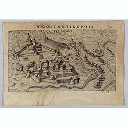
Castel Novo
Very rare view of Herceg-Novi, an important fortress belonging to Venetian Dalmatia captured during the 16th century by the Turks. Published in the first edition of "...
- $350 / ≈ €328
Place & Date: Venice, Giacomo Franco, 1598

Quella Tavola E l'Antica Siria ch'Era destinta in dodici . . .
Very rare view of Holy Land published in the first edition of "Viaggio da Venetia, a Costantinopoli. Per Mare, e per Terra, & infieme quello di Terra Santa. Da G...
Place & Date: Venice, Giacomo Franco, 1598

Scio. (Chios)
Very rare view of Chios Island published in the first edition of "Viaggio da Venetia, a Costantinopoli. Per Mare, e per Terra, & infieme quello di Terra Santa. D...
Place & Date: Venice, Giacomo Franco, 1598

Metileme. (Lesbos)
Very rare map of Lesbos published in the first edition of "Viaggio da Venetia, a Costantinopoli. Per Mare, e per Terra, & infieme quello di Terra Santa. Da Giose...
Place & Date: Venice, Giacomo Franco, 1598
![Citta Di Trav [Trogir]](/uploads/cache/45200-250x250.jpg)
Citta Di Trav [Trogir]
Very rare map centered on the historic town of Trogir published in the first edition of "Viaggio da Venetia, a Costantinopoli. Per Mare, e per Terra, & infieme q...
- $300 / ≈ €281
Place & Date: Venice, Giacomo Franco, 1598
![Spalato [ View of Split]](/uploads/cache/45201-250x250.jpg)
Spalato [ View of Split]
Very rare view of Split published in the first edition of "Viaggio da Venetia, a Costantinopoli. Per Mare, e per Terra, & infieme quello di Terra Santa. Da Giose...
- $450 / ≈ €421
Place & Date: Venice, Giacomo Franco, 1598
![Liesena Isola [Hvar]](/uploads/cache/45202-250x250.jpg)
Liesena Isola [Hvar]
Very rare view map of the Island of Hvar published in the first edition of "Viaggio da Venetia, a Costantinopoli. Per Mare, e per Terra, & infieme quello di Terr...
- $400 / ≈ €374
Place & Date: Venice, Giacomo Franco, 1598
![Glissa. [Klissza or Klis]](/uploads/cache/45203-250x250.jpg)
Glissa. [Klissza or Klis]
Very rare view of Klissza (Klis) published in the first edition of "Viaggio da Venetia, a Costantinopoli. Per Mare, e per Terra, & infieme quello di Terra Santa....
- $300 / ≈ €281
Place & Date: Venice, Giacomo Franco, 1598
![Budova [Budua in Montenegro]](/uploads/cache/45209-250x250.jpg)
Budova [Budua in Montenegro]
Scarce map centered on Budua in Montenegro was published in the first edition of "Viaggio da Venetia, a Costantinopoli. Per Mare, e per Terra, & infieme quello d...
- $450 / ≈ €421
Place & Date: Venice, Giacomo Franco, 1598
![[ Map with part of Albania]](/uploads/cache/45210-250x250.jpg)
[ Map with part of Albania]
Very rare view of part of the coast of Albania published in the first edition of "Viaggio da Venetia, a Costantinopoli. Per Mare, e per Terra, & infieme quello d...
- $450 / ≈ €421
Place & Date: Venice, Giacomo Franco, 1598
![Dulcigno [Ulcinj in Montenegro]](/uploads/cache/45211-250x250.jpg)
Dulcigno [Ulcinj in Montenegro]
Very rare view of Ulcinj in Montenegro published in the first edition of "Viaggio da Venetia, a Costantinopoli. Per Mare, e per Terra, & infieme quello di Terra ...
- $450 / ≈ €421
Place & Date: Venice, Giacomo Franco, 1598
![Durazo [ view of Durres in Albania]](/uploads/cache/45212-250x250.jpg)
Durazo [ view of Durres in Albania]
Very rare view of Durres in Albania published in the first edition of "Viaggio da Venetia, a Costantinopoli. Per Mare, e per Terra, & infieme quello di Terra San...
- $450 / ≈ €421
Place & Date: Venice, Giacomo Franco, 1598
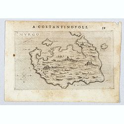
Murgo.
Very rare map of Amorgos published in the first edition of "Viaggio da Venetia, a Costantinopoli. Per Mare, e per Terra, & infieme quello di Terra Santa. Da Gios...
- $300 / ≈ €281
Place & Date: Venice, Giacomo Franco, 1598
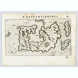
Millo.
Very rare view of Milos Island published in the first edition of "Viaggio da Venetia, a Costantinopoli. Per Mare, e per Terra, & infieme quello di Terra Santa. D...
- $450 / ≈ €421
Place & Date: Venice, Giacomo Franco, 1598
![[View of Osero].](/uploads/cache/45194-250x250.jpg)
[View of Osero].
Very rare view of Osor published in the first edition of "Viaggio da Venetia, a Costantinopoli. Per Mare, e per Terra, & infieme quello di Terra Santa. Da Giosep...
- $400 / ≈ €374
Place & Date: Venice, Giacomo Franco, 1598
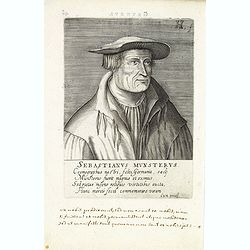
Sebastienus Munsterus.
Rare copper engraved portrait of Sebastian Münster (1488 – 1552) by Henricus Hondius (1573-1666) of The Hague. Published in Jacob Verheiden: "Praestantium aliquot...
- $350 / ≈ €328
Place & Date: The Hague, 1602
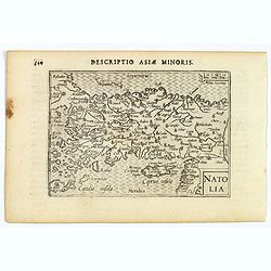
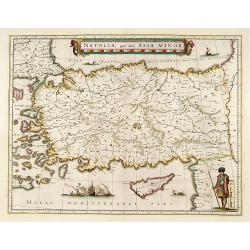
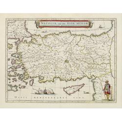
Natoliae Sive Asia Minor.
From the first edition. Map of Turkey, also depicting Cyprus.
- $350 / ≈ €328
Place & Date: Amsterdam, 1606
Natolia.
A miniature map of Turkish Natolia, published by Petrus Bertius in Amsterdam, at the beginning of the seventeenth century. This attractive small map features hatching in ...
- $150 / ≈ €140
Place & Date: Amsterdam, 1606
Natolia.
A miniature map of the Arabian peninsula, including Cyprus. The title cartouche on the lower right corner.First published in 1598 in his Caert-Thresoor, the plates were e...
- $200 / ≈ €187
Place & Date: Amsterdam / Frankfurt, 1609
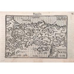
Natoliae Sive Asia Minor.
Map of Turkey, also depicting Cyprus.
- $750 / ≈ €702
Place & Date: Amsterdam, 1610
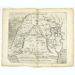
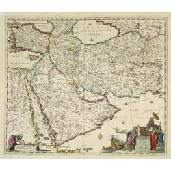
(The great dessert of Arabia)
William Hole's map of the Middle East issued for Sir Walter Raleigh's Historie of the World. The map covers from the Mediterranean and Cyprus to the Persian Gulf and from...
- $400 / ≈ €374
Place & Date: London, 1614
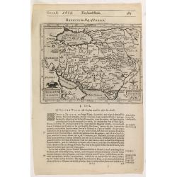
Persicum Regnum.
The rare Samuel Purchas' edition of the Mercator/Hondius Atlas Minor atlas map. Early map of Turkey, including Cyprus published in his famous collection of voyages His Pi...
- $150 / ≈ €140
Place & Date: London, 1625
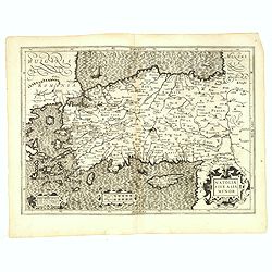
Natolia, quae olim Asia minor.
A finely designed map of Turkey and Cyprus from the great Blaeu family of Amsterdam. The decoration consist of a colored title cartouche, sea monsters, a naval engagement...
Place & Date: Amsterdam, 1635
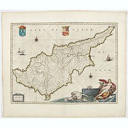
Cyprus Insulae.
Janssonius' beautiful map of Cyprus embellished with a very decorative title cartouche.
Place & Date: Amsterdam, 1640
Selling price: $1800
Sold in 2008
Natoliae.. Aegypti recentior.. Carthaginis (3 maps on 1 sheet)
Map to the left east to the top. Detailed map Turkey, including Cyprus and Crete. Also map of the Nile delta and another map of Tunis. From "Theatrum Orbis Terrarum&...
- $500 / ≈ €468
Place & Date: Antwerp, 1609-1641
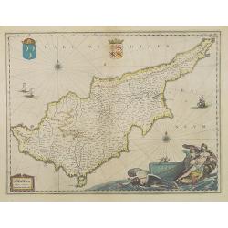
Cyprus Insula.
Blaeu's beautiful map of Cyprus is embellished with a very decorative title cartouche, a scale cartouche, two coats of arms, two wind roses and three sailing ships. From...
- $1800 / ≈ €1684
Place & Date: Amsterdam, 1644
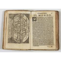
Theatro del Mondo di Abrahamo Ortelio..
Including maps of the world (Shirley, World 214): Europe; Asia; America (Burden, America 126, Marchetti 1598); Africa; England; Scotland; Ireland; Tercera; Spain (4); Por...
Place & Date: Venice, G. Turrini, 1655
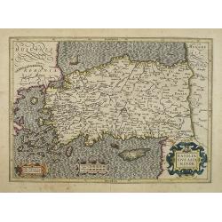
Natolia, quae olim Asia minor.
A finely designed map of Turkey and Cyprus from the great Blaeu family of Amsterdam. The decoration consist of a colored title cartouche, sea monsters, a naval engagement...
- $450 / ≈ €421
Place & Date: Amsterdam, 1658
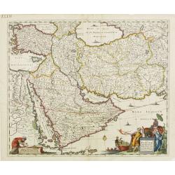
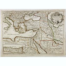
Nova Persiae, Armeniae, Natoliae et Arabiae.
East from Cyprus to Iran with numerous place names and ornamental cartouches below. There are vignettes of sailing ships in sea areas and the land divisions of the time a...
- $1100 / ≈ €1029
Place & Date: Amsterdam, 1660
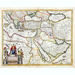
Turcicum Imperium. Concordia res parvæ crescunt discordia maximæ dilabuntur.
An impressive and attractive map with a particularly fine cartouche showing the Turkish Sultan on his throne and allegorical figures at either side brandishing weapons.Sa...
- $1100 / ≈ €1029
Place & Date: Amsterdam, 1667
Natolie ou Asie mineur, Lieües d'Alemag.
Rare map of Turkey and Cyprus published by Jollain in 1667. Published in "Trésor Des Cartes Geographiques Des Principaux Estats de Lunivers".This atlas is base...
- $250 / ≈ €234
Place & Date: Paris, 1667
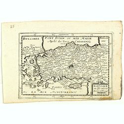
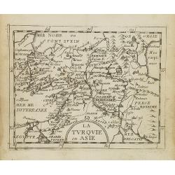
La Turquie en Asie.
Uncommon miniature map of Turkey, Cyprus, Palestine, Iran, and Iraq. From Pierre Duval's "La Geographie Universeille" dated 1676. Following his "Cartes de ...
- $75 / ≈ €70
Place & Date: Paris, 1676
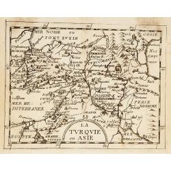
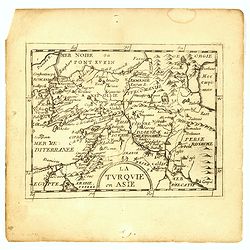
La Turquie en Asie.
Uncommon miniature map of Turkey, Cyprus, Palestine, Armenia, Iran and Iraq. From Pierre Duval's La Geographie Universeille dated 1676. Following his Cartes de geographie...
- $90 / ≈ €84
Place & Date: Paris, 1676
La Turquie en Asie.
Uncommon miniature map of Turkey, Cyprus, Palestine, Iran, Iraq. From Pierre Duval's "La Geographie Universeille" dated 1676. Following his "Cartes de geog...
- $100 / ≈ €94
Place & Date: Paris,1676

Nova Persiae Armeniae Natoliae et Arabiae.
This fine map shows the area East from Cyprus to Iran, including The Saudi Peninsula, Red Sea, Nile River, Cyprus, Asia Minor, the Gulf of Aden, the Indian Ocean, Armenia...
- $1000 / ≈ €936
Place & Date: Amsterdam, 1680
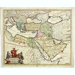
Turcicum Imperium.
Detailed map of the Turkish Empire by Holland's leading mapmaker at the end of the seventeenth century. The cartouche shows an Ottoman administrator or possibly the Sulta...
- $900 / ≈ €842
Place & Date: Amsterdam, 1680
La Turquie en Asie, l'Arabie et la Perse.
Uncommon map centered on Arabian Pen Insular and Turkey, Cyprus, Palestine, Iran, Iraq.Pierre Du Val (1619-1683) was one of the most influential and prolific mapmakers an...
- $2500 / ≈ €2339
Place & Date: Paris, 1684
L'Empire des Turcs en Europe, en Asie et en Afrique.
A nice map showing the Turkish Empire, including an inset map of kingdom of Alger. Extending from Italy and the Eastern Mediterranean in the west to the Caspian Sea and P...
- $550 / ≈ €515
Place & Date: Paris, 1686
Nova Persiae Armeniae Natoliae et Arabiae.
East from Cyprus to Iran with numerous place names and ornamental cartouches below. There are vignettes of sailing ships in sea areas and the land divisions of the time a...
- $1500 / ≈ €1404
Place & Date: Amsterdam, 1690

Accuratissima et maxima totius Turcici Imperii..
Rare issue of T. Danckert's attractive map showing the Arabian Peninsular, Turkey, Cyprus, Egypt and eastern part of the Mediterranean.Decorative title cartouche lower le...
- $1100 / ≈ €1029
Place & Date: Amsterdam, 1700
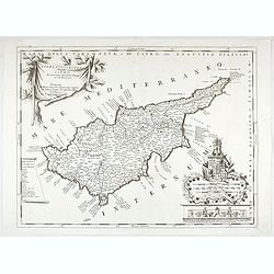
Acamantis insula hogidi Cipro . . .
Decorative map of Cyprus. The remarkable Vincenzo Coronelli (1650-1718), was a Franciscan Friar and appointed General of the Order in 1701. He was cosmographer to the Rep...
- $3500 / ≈ €3275
Place & Date: Venice, 1700
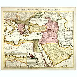
Imperium Turcicum Complectens Europae, Asiae, et Africae, Arabiae que Regiones ac Provincias Plurimas Industria et Labore . . .
Petrus Schenk's map of the Ottoman Empire, is based upon an earlier map by Sanson. It is showing from Italy to the Caspian Sea and the Saudi Peninsula, centered on Cyprus...
- $900 / ≈ €842
Place & Date: Amsterdam, circa 1705
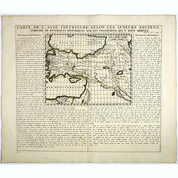
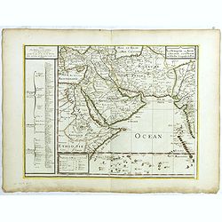
Carte De L'Asie Inferieure Selon Les Auteurs Anciens, Enrichie de Remarques Historiques sur les Changemens qui y sont arrivez.
Text page with inset map (220x269.mm.) of Turkey, including Cyprus from Chatelain's monumental 7 volume "Atlas Historique". Henri Abraham Chatelain (1684 – 17...
- $200 / ≈ €187
Place & Date: Amsterdam, 1720

A Map of Turky, Arabia And Persia. Corrected from the latest Travels. . .
FIRST EDITION Fine map of the Turkish Empire, centered on Saudi Arabia, Cyprus and the Mediterranean Sea. Dated 1711, "Sold by John Senex at the Globe aga inst St....
- $1500 / ≈ €1404
Place & Date: London, 1721