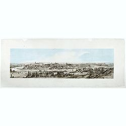
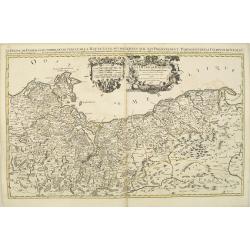
![Sexta Etas Mundi. Bressla. [Breslau or Wrocław] CCXXXIIII.](/uploads/cache/33138-250x250.jpg)
Sexta Etas Mundi. Bressla. [Breslau or Wrocław] CCXXXIIII.
A very fine presentation of the city of Bresslau / Wrocław (230 x 520mm.), in Poland, centered on the cathedral (Dim. : 232 mm W : 520 mm).Overleaf, the kings Wenceslaw ...
Place & Date: Nuremberg, 12 July 1493
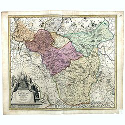
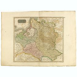
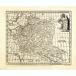
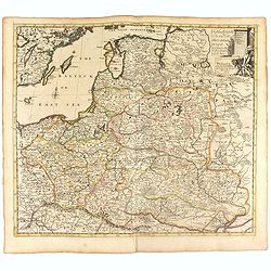
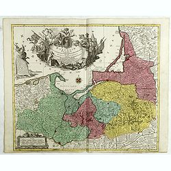
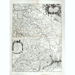
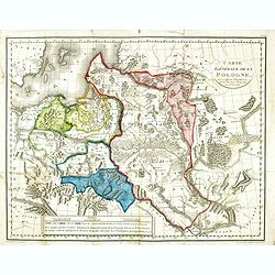
Regni Poloniae, ducatus Mazoviae et province Cujaviae / descriptio emendata per R. & I. Ottens
Very rare map of Poland Lithuania and Ukraine, etc. Engraved by A. Schut.Joachim Ottens (1663 - 1719) and his sons Renier and Joshua were prominent Dutch booksellers and ...
Place & Date: Amsterdam, 1725
Selling price: $1500
Sold in 2017
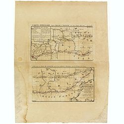
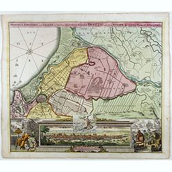
Polnische Reise Karte uber die vornehmsten Passagen von Dresden nach Warschau auf zweyerley Wegen I) uber Breslau, Peterkau und II) uber Lissa, Kaliez . . . 1751
Scarce strip-style road map showing two roads from Dresden via Glogau or Breslau to Warsaw.A key identifies villages, markets and post offices along the routes. Printed i...
Place & Date: Nurember, 1751

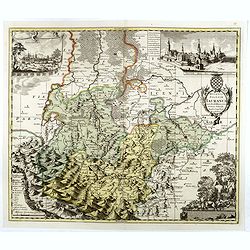
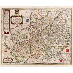
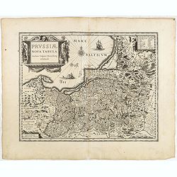
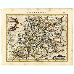
Silesiae typus..
Fine and early map of Silesia after Martin Helwig (1516-1574) and used by A.Ortelius in his atlas 'Theatrum Orbis Terrarum [Atlas of the Whole World].Only included in the...
Place & Date: Antwerp, 1598
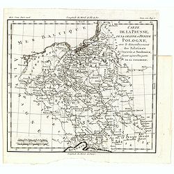
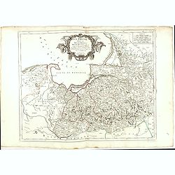
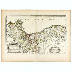
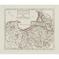
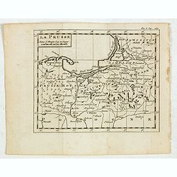
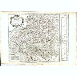
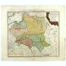
Carte de la Prusse, de la Grande et Petite Pologne, avec le démembrement des Palatinats de Cracovie et Sandomirz, faisant aujour d'hui partie de la Lodomerie.
A map of the Polish territories by Louis Brion de la Tour, from the work "Histoire universelle depuis le commencement du monde jusqu a present" published in Par...
Place & Date: Paris, 1779
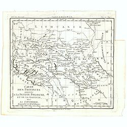
Carte des provinces annexées à la petite Pologne, et de la Gallicie, avec la Lodomerie, démembrées de la Pologne.
A map of the southern provinces of Poland by Louis Brion de la Tour, from the work "Histoire universelle depuis le commencement du monde jusqu a present" publis...
Place & Date: Paris, 1779
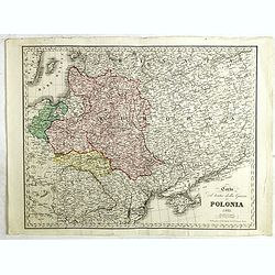
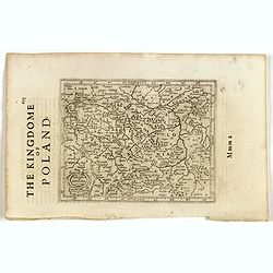
Poland As Divided.
This map covers Poland following Napoleonic Wars and the treaties of the 1815 Congress of Vienna.This map was first published in Thomson's New General Atlas of 1814. John...
Place & Date: Edinburgh, 1817
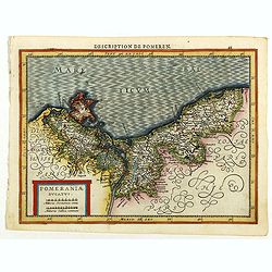
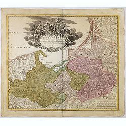
Pomeraniae Ducatus.
Pomerania map from the rare Cloppenburg edition slightly larger format and more scarce edition of the Mercator/Hondius "Atlas Minor". Small and detailed map of ...
Place & Date: Amsterdam, 1630
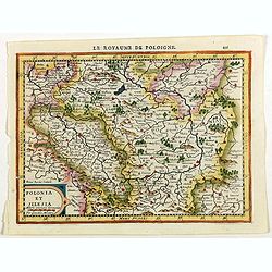
Polonia et Silesia.
Map of Poland and Silesia from the rare Cloppenburg edition slightly larger format and more scarce edition of the Mercator/Hondius "Atlas Minor". Engraved by Pi...
Place & Date: Amsterdam, 1630
Estats de la Couronne de Pologne.
Map of Poland prepared by N.Sanson and published by F. Halma.Published in an Dutch edition of the small Sanson atlas L'Europe Dediée a Monseigneur . . . Le Tellier Secre...
Place & Date: Amsterdam, Utrecht, 1683
Estats De La Couronne De Pologne ou sont les Royaume de Pologne, Duches et Provinces De Prusse, Cuiave, Mazovie, Russie Noire &c.
Fine map of Poland, state with erased date. Engraved by J.Sommer.Nicolas Sanson was to bring about the rise of French cartography, although the fierce competition of the ...
Place & Date: Paris, 1663
Polonia.
A miniature map of the Polish-Lithuanian Commonwealth, published by Petrus Bertius, in Amsterdam at the beginning of the seventeenth century. It features a small strap-wo...
Place & Date: Amsterdam, 1606
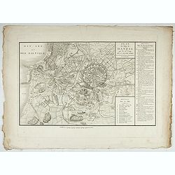
Accueil Consultation Plan du Siège de Danzig par le 10me. Corps de la Grande Armée, Avec les travaux des Français, tels qu'ils étaient le 25 Avril 1807.
A map of the siege of Danzig, 19 March-24 May 1807, showing the positions of the French siege works as they stood on 23 April. Napoleonic Wars (1803-15). Oriented with so...
Place & Date: Paris, after 1810
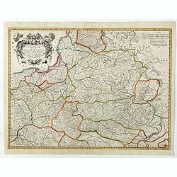
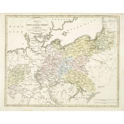
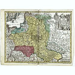
Generale Carte der gesamten Koniglichen Preussischen Lander. . .
Beautiful and rare two-sheet map of Prussia with part of now-a-days Poland. The title cartouche is hold by a crowned eagle. In lower part a large baroque cartouche with a...
- $3000 / ≈ €2807
Place & Date: Berlin, 1760
![Partie septentrionale du cercle de Haute Saxe [...] Brandebourg.](/uploads/cache/33211-250x250.jpg)
Partie septentrionale du cercle de Haute Saxe [...] Brandebourg.
Finely and crisply engraved map of north eastern part of Germany, including part of Poland. With inset map of Brandenburg. Map by Giles Didier Robert De Vaugondy with era...
- $150 / ≈ €140
Place & Date: Paris, c. 1760
Poland Lithuania and Prussia.
Uncommon miniature map of Poland, Lithuania and the Ukraine, engraved by Thomas Kitchin - with his signature in lower right bottom.
- $300 / ≈ €281
Place & Date: London, 1782
La Prusse divisée en Prusse Royale et Prusse Ducale.
The map extends from Memem, Danzig and Rosienne in the North to Novigrod in the southeast and Thorn on the Wessel in the southwest. Shows the Gulf of Danzig and part of P...
- $200 / ≈ €187
Place & Date: Venice, 1776 - 1784
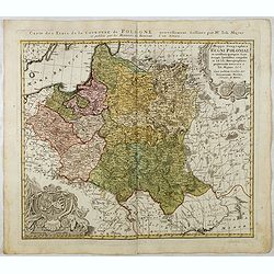
Mappa Geographica Regni Poloniae ex novissimis quotquot sunt mappis specialibus composita et al L.L. Stereographicae projectionis revocata a Tob. Mayero. . . .
Decorative map of Poland after Tobias Mayer who was based on Barnikel's map of Curland (1747) and Jan Nieprzecki's map of Lithuania (1749).Poland extends from Glogau and ...
- $600 / ≈ €561
Place & Date: Nuremberg, 1757
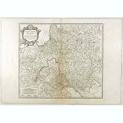
Le Royaume De Pologne, divise selon les Partages faits en 1772, 1793 et 1795, etnre la Russie, la Prusse et l'Autriche . . .
The uncommon later edition of this detailed map of Poland, showing the lands lost to Russia, Prussia and Austria in 1772, 1793 and 1795. with a color key added underneath...
- $600 / ≈ €561
Place & Date: Paris, ca. 1796
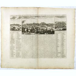
Carte Des Trois Ordres Qui Composent L'Etat De La Republique De Pologne...
Decorative views of Cracow, Warsaw and Vilna, from Chatelain's monumental Atlas Historique.Zacharie Chatelain (d.1723) was the father of Henri Abraham (1684-1743) and Zac...
- $600 / ≈ €561
Place & Date: Paris, 1732
Ducatus Silesiae Iauranus. Aut : Frid : Kühnovio. . .
Rare Pieter Schenk edition of Friedrich Kubn's (Kühnovio) map of Jawor in southwest Poland based on Johann Gottfried Bartsch, map first published in Świdnica (then Schw...
Place & Date: Amsterdam, 1700-1725
Selling price: $1250
Sold in 2017
Prospect, Grundriss und Gegend der Polnischen vesten Reichs und Handels-Stadt Dantzig und ihrem Werder. . .
Striking example of Homann's map of Danzig (Gdansk) and neighboring regions and striking birds eye view, major port to the Baltic Ocean, which for centuries was an import...
- $550 / ≈ €515
Place & Date: Nuremberg, ca. 1720
Widok Krakowa od Podgonza.
Bird's-eye view of Krakow city, with underneath the names of thirteen important buildings. Lithographed by J.Brydak after a photo by W. Rzewuskriego. Published by Czasu W...
- $750 / ≈ €702
Place & Date: Krakow, ca. 1865
Carta del Teatro della Guerra in Polonia - 1831.
Oversized rare 1831 war map of Poland and Lithuania published during the Polish - Russian War in 1831, published by Presso l'incisore Stanislao Stucchi. Stucchi, was born...
- $900 / ≈ €842
Place & Date: Milan, 1831
Part of Prussia.
Attractive example of the scarce 1828 Malte-Brun map of modern day Poland and Lithuania. Published by Samuel Walker in 1828 as part of the American edition of Conrad Malt...
- $100 / ≈ €94
Place & Date: Boston, 1828
Polonia secondo le obzervazioni dell'accademiadi Parigi.
Uncommon Italian map of present day Poland and Lithuania prepared by Claude Buffier was a Jesuit theologian and geographer working in Paris, who wrote the Geographie Univ...
- $150 / ≈ €140
Place & Date: Naples, Rome, ca. 1725

Carte De La Prusse Occidentale ou sont tracees les Provinces cedees Par la Pologne au Roi De Prusse . . . 1775
Finely and crisply engraved map of Western Prussia, now part of Poland on the Baltic Sea, including the Bay of Danzig. With ornamental title cartouche and noteworthy topo...
- $250 / ≈ €234
Place & Date: Venice, 1776 - 1784
Regnum Borussiae gloriosis auspicijs Seerenissimi et Potentissimi Princip Friderici III Primi . . .
Map covering the region along the Baltic Sea from Prussia, Memel, to northern Poland, extending south to Poland, centered on Danzig, Konigsberg, Heilsperg, etc. Beautiful...
- $350 / ≈ €328
Place & Date: Nuremberg, 1720
Plan von der Stadt Pullusk alwo der Konig von Sweden Carl XII den Saxischen Feldmarschall Steinau. . .
Rare plan of the Battle of Pultusk which took place on April 21, 1703 in Pultusk during the Great Northern War. The Swedish army under the command of Charles XII defeated...
- $450 / ≈ €421
Place & Date: Frakfurt, Merian heirs,1717
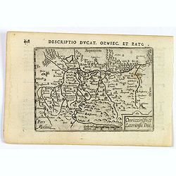
Descriptio Ducat. Ozwiec. et Zato.
An original early 17th century copper engraved miniature antique map of the Oswiecim (Auschwitz) and Zator area of southern Poland by Petrus Bertius. The title is display...
- $100 / ≈ €94
Place & Date: Amsterdam, 1606
Silesia Inferior..
Decorative map prepared by Jonas Scultetus, a Silesian cartographer (1603-1664).
- $400 / ≈ €374
Place & Date: Amsterdam, 1650
Cracovie.
View of Cracow. From the French text edition of Description d'Univers... By Allain Manneson Mallet (1630-1706), a well travelled military engineer and geographer who work...
- $300 / ≈ €281
Place & Date: Paris, 1683
![[Untitled map of a part of Poland and Prussia].](/uploads/cache/25710-250x250.jpg)
[Untitled map of a part of Poland and Prussia].
Large folding map, being upper right part of a multi-sheet map, showing the northern part of Poland with good detail around Gdansk. Published by Jean Claude Dezauche (17...
- $400 / ≈ €374
Place & Date: Paris, ca. 1816-1824
Karta öfver Preussiska riket.
An very rare map of Eastern part of Germany, with Pomerania and part of present-day Poland with Swedish text. This is an updated version of his map of 1820 and is now dat...
- $150 / ≈ €140
Place & Date: A. Wiborgs förlag, Stockholm, ca. 1848
La Prusse divisée en Prusse Royale et Prusse Ducale.
The map extends from Memem, Danzig and Rosienne in the North to Novigrod in the southeast and Thorn on the Wessel in the southwest. Shows the Gulf of Danzig and part of P...
- $300 / ≈ €281
Place & Date: Venice, 1776 - 1784
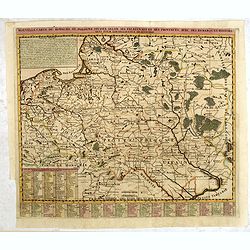
Nouvelle carte du royaume de Pologne, divisée selon..
Chatelain's map of Poland. The title is in two lines across the map. On bottom border appears an index to the map's contents. At the top of the map appear historical rema...
- $700 / ≈ €655
Place & Date: Amsterdam, 1719
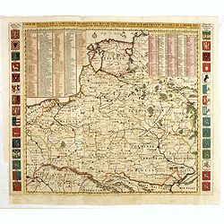
Carte De Pologne Avec La Chronologie Des Rois Et Des Ducs De Lithuanie, Ainsi Que Des Grands M. De L'Ordre Teutonique Les Evechez et Archeveches, et Les Armes Des Provinces . . .
Map of Poland with a key table to the towns, and 30 coats of arms on both sides, extending south the Black Sea. From Chatelain's monumental 7-volume "Atlas Historiqu...
- $1750 / ≈ €1638
Place & Date: Amsterdam, 1720
Prussiae nova tabula.
The map features a bold title cartouche, a ship, compass rose and a sea monster in the Baltic Sea. As indicated in the title cartouche, the map was prepared by the German...
Place & Date: Amsterdam, 1634
Selling price: $80
Sold in 2015

Carte de la Pologne Autrichienne contenant La Russie Rouge et la partie méridionale du Palatinat de Cracovie . . .
Detailed map with Krakow, including the areas of Malopolskie and Podkarpackie and including present-day Ukraine.Santini gives credit to Homann Heirs in the cartouche. Mal...
- $300 / ≈ €281
Place & Date: Venise 1776-1784
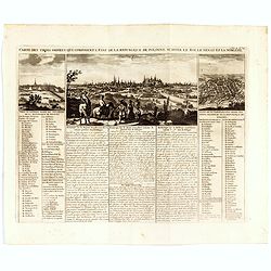
Carte Des Trois Ordres Qui Composent L'Etat De La Republique De Pologne...
Decorative views of Cracow, Warsaw and Vilna, from Chatelain's monumental Atlas Historique.Zacharie Chatelain (d.1723) was the father of Henri Abraham (1684-1743) and Zac...
- $800 / ≈ €749
Place & Date: Amsterdam, 1732
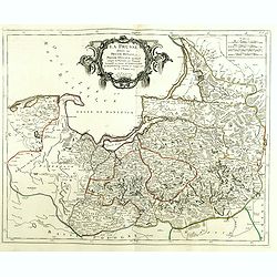
HERTZOGTHUMB POMMERN DUCHE DE POMERANIE divise en ses Princip les Parties qui sont les Princip te de Rugue, Duche de Stettin, Pomeranie, Cassubie, et Wandalie . . .
Very fine map of the northern part of Poland. Nice details of forests, villages and rivers. Two nice uncolored cartouches.Nicolas Sanson was to bring about the rise of Fr...
- $300 / ≈ €281
Place & Date: Paris, 1654
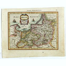
Prussia .
Important early map showing coast of Baltic Sea in Prussia, today Poland, prepared by the German cartographer Gaspher Henneberg of Erlich. Embellished with a large strapw...
- $600 / ≈ €561
Place & Date: Amsterdam, 1612
Poland and other the Countries belonging to the Crowne According to the Newest Observation 1719
Fine map of the Polish Empire in a second edition of the map, which had been published by Morden & Browne in 1710. The remnants of the earlier address, are still slig...
- $1200 / ≈ €1123
Place & Date: London, 1721
Polonia regnum ut et magni Ducat Lithuania. . .
Miniature map of Poland, a reduction of the appropriate part of Seutter's folio map. Engraved by Tobias Conrad Lotter.From Atlas Minor, here published by Johann Martin Wi...
- $450 / ≈ €421
Place & Date: Augsburg, J.M.Will, 1778
Borussiae Regnum compectens Circulos Sambiensem, Natangiensem, et Hockerlandiae Nee non Borussia Polonica, exhibens Palatinatus Culmiensem. . .
Decorative map covering northern Poland with Prussia, Pomerania, Hockerlandia, Warmiaermelandia, Natanglensis, Galindia, Nandrovia, Sclavonia, and the Baltic Sea. Include...
- $400 / ≈ €374
Place & Date: Augsburg, ca. 1760

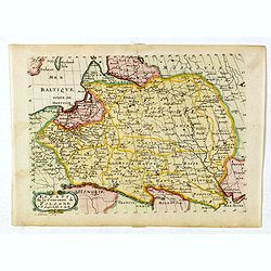
Pascaarte van een deel der Oost Zee, tusschen Bornholm ende der Memel, vertonende de ware gelegentheijt der Zeecusten van Pruijssen. . .
This very rare chart of the Northern Coast of Poland with Gdansk, appeared in the rare English edition of Willem Blaeu's 'Het Licht der Zeevaert', an atlas of sea charts ...
- $4000 / ≈ €3743
Place & Date: Amsterdam, 1608
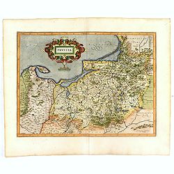
Prussia .
An early map of northern Poland from the "Atlas Minor" (Gerhard Mercator / Jodocus Hondius). Extends from Memel to Torun and the Narew River. With two sailing s...
- $300 / ≈ €281
Place & Date: Amsterdam, 1612
Borussiae Regnum compectens Circulos Sambiensem, Natangiensem, et Hockerlandiae Nee non Borussia Polonica, exhibens Palatinatus Culmiensem. . .
Decorative map covering northern Poland with Prussia, Pomerania, Hockerlandia, Warmiaermelandia, Natanglensis, Galindia, Nandrovia, Sclavonia, and the Baltic Sea. Include...
- $400 / ≈ €374
Place & Date: Augsburg, 1759

Prussiae Regionis Sarmatiae Europae Nobilissimae Novaet vera descriptio . . .
Nice example of the first edition of De Jode's map of Prussia, from the 1593 edition of De Jode's atlas.The present map is an entirely new addition to the second De Jode ...
- $2000 / ≈ €1871
Place & Date: Antwerp, 1593
Nouvelle carte du royaume de Pologne, divisée selon..
Chatelain's map of Poland. The title is in two lines across the map. On bottom border appears an index to the map's contents. At the top of the map appear historical rema...
- $1100 / ≈ €1029
Place & Date: Amsterdam, 1719
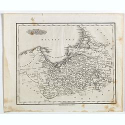
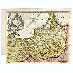
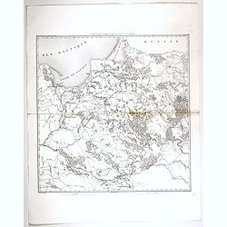
![[No title] Northern part of Poland.](/uploads/cache/24263-250x250.jpg)
[No title] Northern part of Poland.
Attractive map centered on the northern part of Poland, including northern part of Eastern Germany.Prepared by Giovanni Antonio Bartolomeo Rizzi Zannoni, one of the leadi...
- $275 / ≈ €257
Place & Date: Paris, ca 1783
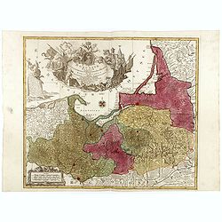
Royaume de Prusse et Prusse Rle. ou Polonoise.
On the left is Pomerania and the Desert of Waldow. At the top of the map is Memel and Samland. On the right side is the Biss River and Kautten. In the center of the map i...
- $125 / ≈ €117
Place & Date: Paris, later than 1749
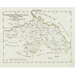
Oesterreich. B. Galizische Erbstaaten Koenigr: Galizien Kreis 1. Lemberg 2. Zloczow 3. Zolkiew.
Map depict the area north of the Black Sea, including the cities of Lemberg, Zolkiew, Brody.From "W. E. A. von Schliebens Atlas von Europa nebst Kolonien für Gesch�...
- $150 / ≈ €140
Place & Date: Leipzig, G. J. Göschen, ca 1825-1830
Le Duche de Pomeranie divise en ses principales parties. . .
Fine map of Pomerania with a decorative title and scale cartouche.The map notes Nicolas Sanson as the mapmaker and claims that the map was published by Alexis-Hubert Jail...
- $550 / ≈ €515
Place & Date: Amsterdam, 1693
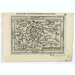
Oswiec. et Zatorien. Ducatus.
Miniature map of Poland from "Il Theatro del Mondo," which was a plagiarized version of Ortelius' pocket atlas published specifically for the Italian market by ...
- $200 / ≈ €187
Place & Date: Brescia, 1598
Silesia Inferiore Dedicata Dal P. Cosmografo Coronelli All'Illustrissimo Eccelleniss. S. GIO: BATTISTA GRADENIGO, Senatore Amplissimo
Uncommon map of lower Silesia engraved in Coronelli's strong and distinctive style. In upper right corner a imposing dedicational cartouche surmounted by coats of arms an...
- $400 / ≈ €374
Place & Date: Venice, 1695
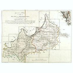
(Index sheet) General Tableau zur Karte von Alt Ost und West Preussen nebst dem aufgenommenen Trigonometrischen Netz. . .
Index sheet of this important multi sheet map of Prussia, Lithuania and Poland.Section XXIV of the rare first edition of this important 25-sheet map prepared by Friedrich...
- $300 / ≈ €281
Place & Date: Berlin, 1802-1810
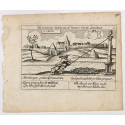
St. Cruis ( in eastern Poland.)
A very nice view of Kloster Heiligkreuz (Swiety Krzyz), in eastern Poland. In the foreground, a man climbing up a column is depicted. With a verse in two languages undern...
- $120 / ≈ €112
Place & Date: Frankfurt, 1623-1778
La Prusse.
Fine miniature map of Prussia, likely published by Claude Buffier. In upper right corner "Tom.I. Pag. 283.
- $150 / ≈ €140
Place & Date: Paris, ca. 1759
Oswiecz et Zantor.
An attractive miniature map of Oswieczin and Zator in the Southern part of Poland, with major cities named. Strapwork title cartouche at the bottom. French text on verso....
- $125 / ≈ €117
Place & Date: Antwerp, 1601
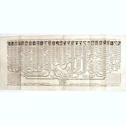
Nouvelle carte genealogique des souverains et des familles illustres aliez a la maison ou aux decendans de la famille roialle de Piaste roi de Pologne. . .
A two sheet engraving of the genealogical family tree of Poland from 804 AD to the time of publication. The tree extends throughout Europe and is headed by the arms of 30...
- $150 / ≈ €140
Place & Date: Amsterdam, 1719-1732
Il Ducato di Silesia et il Marchesato di Moravia
Scarce two-sheet map of the region along the River Oder in Poland, including parts of Chez Republic and Hungary. Excellent detail throughout. Large and decorative title a...
- $1200 / ≈ €1123
Place & Date: Rome, 1692
Prussiae nova tabula.
Rare map of Prussia with nowadays Poland. The map features a bold title cartouche, a ship, a compass rose, and a sea monster in the Baltic Sea. The map was prepared by th...
- $550 / ≈ €515
Place & Date: London, 1624
Royaume de Pologne.
Detailed map encompassing present-day Poland. The table provides a breakdown of the sub-regions of the Polish Crown.Venetian edition of the map by R. de Vaugondy, to whom...
- $350 / ≈ €328
Place & Date: Venice, 1776 - 1784
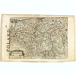
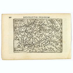
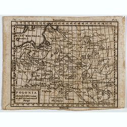
Polonia. (With text page)
Early map of Poland (168x250mm.) printed on a text page, together with another giving a description of the region in English.
- $150 / ≈ €140
Place & Date: Amsterdam, 1612
Polonia et Silesia. (With text page)
Early map of Poland. With English title above the map and an description of the region in English on verso.
- $250 / ≈ €234
Place & Date: Amsterdam, 1612

Mapa Polski i Krajów Osciennych - Wydanie trzecie. Opracowal Stanislaw Max. Wydani M. Arcta.
‘The Birth of Modern Poland on a map’ - an excellent wall map of Poland and surrounding regions, published in Warsaw near the end of World War I, when Poland’s fate...
- $1000 / ≈ €936
Place & Date: Warsaw, [H. Sklodowski], 1918
Carte du pays compris entre Vistule et la Pregel.
Map of Poland regions, including Warsaw, part of Russia and Danzig bay, prepared by Auguste Henri Dufour (1798-1865). Engraved by Ch. Dyonnet.
- $75 / ≈ €70
Place & Date: Paris, 1830
Ducatus Silesiae Glosani.
Charming map of the Silesia from the Mercator Hondius “Atlas Minor” published in Amsterdam in 1648 at Janssonius with German text on verso. Engraved by Petrus Kaerius...
- $200 / ≈ €187
Place & Date: Amsterdam, 1648
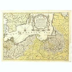
A New and Accurate Map of the Kingdom of Prussia, Pomerania, Courland & the Adjacent Parts Bordering on the Baltick Sea.
Attractive uncommon detailed map of the Kingdom of Prussia and the neighbouring regions, showing much of modern day Poland. Published in 'Universal Magazine', and well en...
- $750 / ≈ €702
Place & Date: London, 1757
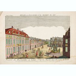
Prospect des Rossmarcktes zu Statin - Vue du Marché aux Cheveaux a Stettin.
Rare so-called optical print illustrating the Horse market of Stettin in Poland. Engraved by F. Riedel. The Academie Imperiale was a well-known publisher of optical print...
- $600 / ≈ €561
Place & Date: Augsburg, 1760
Charte von Russisch Litauen, welche die von Polen an Russland Abgetretene Woiewodschaften, Liefland, Witepsk, Mscislaw, und einem Theil der Woiewodschaften Polock und Minsk Enthalt.
An uncommon map of Belarus, together with parts of the Ukraine and Lithuania. Shows the rivers Dnieper and Dwiner from Liefland to Mscislaw and Woiwodschaft.. With the to...
- $500 / ≈ €468
Place & Date: Nuremberg, 1775
A New Map of the Kingdom of Prussia with its Divisions Into Provinces and Governments. . .
A fine map by John Cary of Prussia, in what is now northern Poland and Lithuania. John Cary was considered "the most representative, able and prolific of English car...
- $250 / ≈ €234
Place & Date: London, 1811
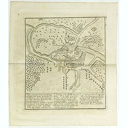
![[manuscript plan] Siège de Schweidnitz en Silésie fait par les trouppes Imperial es commandées par Mr. le de Nadasti ...](/uploads/cache/39893-250x250.jpg)
[manuscript plan] Siège de Schweidnitz en Silésie fait par les trouppes Imperial es commandées par Mr. le de Nadasti ...
This fine manuscript shows the layout of the city of Swidnica with its surrounding defence wall, its advanced bastions and suburbs, roads and two nearby villages. In lowe...
- $2750 / ≈ €2573
Place & Date: France, 1769
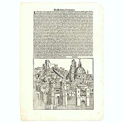
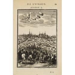
De Polonia Sarmatica - Lituania. CCLXXIX
An imaginary view of a Lithuanian or Polish City (190 x 223mm.) , however the earliest obtainable view of this period.Page from the richest illustrated Incunabula, the fa...
- $400 / ≈ €374
Place & Date: Nuremberg, 12 July 1493
![[Mer Baltique]](/uploads/cache/37796-250x250.jpg)
[Mer Baltique]
Detailed map of Northern part of Poland with Danzig, from his "Atlas moderne ou collection de cartes...".map N° 15.
- $300 / ≈ €281
Place & Date: Paris, 1762
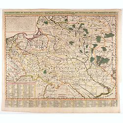
Carte générale de la Pologne : avec ses différens démembremence par les puissances partageantes en 1773 et 1795 / dessinée et dressée par Mariaval. . .
Very rare map of Poland, engraved by Tardieu l’Ainé, active at rue de Sorbonne 385.
- $750 / ≈ €702
Place & Date: Paris, ca. 1795
Mappa Geographica Regni Poloniae ex novissimis quot quot sunt mappis. . .
A map of Poland, Lithuania and Belarus, first published in 1750 by Homann Heirs, and now re-issued in 1773. Coastline includes all between Riga and Gdansk. Map is based o...
- $500 / ≈ €468
Place & Date: Nuremberg, 1773
Reino de Polonia ò sea la parte unida a la Rusia por el repartimiento de 1795 que conserva el nombre de aquel antiguo reino.
Uncommon Spanish map of Poland from "Coleccion de mapas geograficos antiguos y modernos de autores clascicos", published by José Torner in Barcelona in 1831.R....
- $80 / ≈ €75
Place & Date: José Torner, Barcelona, 1831
Provincia ecclesiastica di Gnesna e Posnania nella Prussia Vicar.ti apost.cl di Sassonia e Dei Ducati Analtini (Tav LXXXII)
A large-format map of western Poland with its different dioceses. The map is finely engraved and beautifully colored and was prepared by Girolamo Petri, a lawyer who serv...
- $500 / ≈ €468
Place & Date: Rome, 1858