Browse Listings in Europe > Netherlands
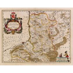
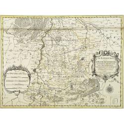
Ducatus Limburg.
In 1616 prepared by Aegidio Martini. Includes the towns of Maastricht as well as of Aachen. A very large title cartouche with two putti.
Place & Date: Amsterdam 1639
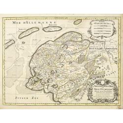
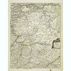
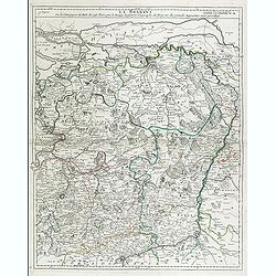
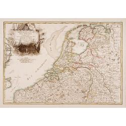
La seigneurie d'ouest-Frise ou Frise Occidentale
Fine map of the Friesland with a decorative title and scale cartouche.Alexis-Hubert Jaillot (1632-1712), was a French cartographer. He joined the Sanson heirs and redrew ...
Place & Date: Amsterdam, 1692
![Groeninga MDLXXIII. [Groningen]](/uploads/cache/27192-250x250.jpg)
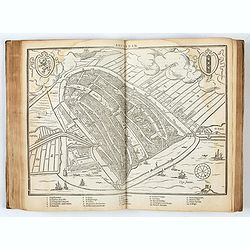
Groeninga MDLXXIII. [Groningen]
RECTO: A panoramic view of the city of Groningen dated 1573.VERSO: a woodcut of a cow, a bull and their calf.Taken from Sebastian Munster's encyclopedic work, the "C...
Place & Date: Basle, ca. 1564
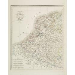
Royaume des Pays-Bas . . .
Detailed map of the Netherlands, Belgium and Luxembourg, prepared by A. H. Basset, rue Saint-Jacques, no. 64, Paris and published in Atlas classique et Universel de Géog...
Place & Date: Paris, A.H. Basset, 1828
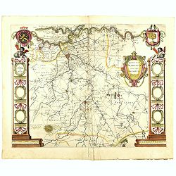
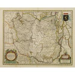
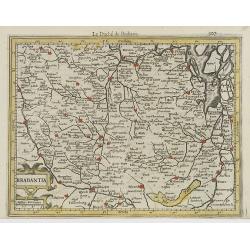
Quarta pars Brabantiae cujus caput Sylvaducis.
The coat of arms of Brabant and 's-Hertogenbosch do appear on the map. But the municipal arms in the columns on right and left-hand side have not yet been filled in. The...
Place & Date: Amsterdam, 1645
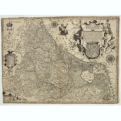
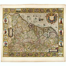
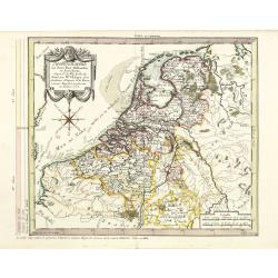
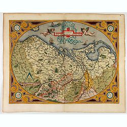
Inferior Germania.
Very rare map of the Benelux, centered on the Netherlands. According to van der Heijden only known in 6 examples. Two compass-roses with rumb lines but without the names ...
Place & Date: Amsterdam,ca. 1600
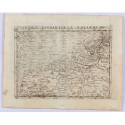
Flandria Barbantia e Holanda No.
Gastaldi's modern map of the Low Countries of the Netherlands, Belgium and Luxembourg. It includes parts of England, France and Germany.According to van der Heijden This ...
Place & Date: Venice, 1548
Selling price: $450
Sold in 2021
Tabula Ducatus Brabantiae continens Marchionatum Sacri Imperii et Dominium Mechliniense emendate à F. de Wit 1666
Shows present-day Belgium and Dutch province of Brabant. Including the Maas and Waal rivers. Shows Antwerp, Brussels, Namur, Liege and Venlo among other towns and cities....
Place & Date: Amsterdam, 1680
Selling price: $25
Sold in 2016
Belgii sive Germaniae Inferioris accuratissima tabula.
Very rare and very decorative map with in the right and left borders costumed figures and town plans alternately. In top and bottom border town plans and views.Separate p...
Place & Date: Amsterdam, 1631

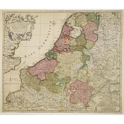
Belgium Foederatum emendate auctum et novissimé editum.
Fine detailed map of the area of the modern Netherlands less the southern part of Limburg. Title cartouche representing the commerce, the arts and the sciences. The Lion ...
Place & Date: Amsterdam, 1680
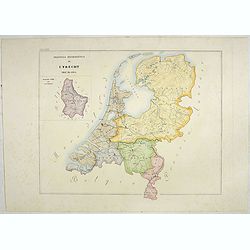
L'Utrecht. . .
Although not renowned for the originality of his work, Pieter van der Aa is highly thought of for the design and quality of his output. Showing Dutch province of Utrecht....
Place & Date: Amsterdam, 1713

Tabula ducatus Limburch et comitatus Valckenburch. . .
The map describes the southern part of Limburg and reaches into Belgium (Liege, Verviers) and Germany. With two very decorative cartouches.
Place & Date: Amsterdam, 1690
Quarta pars Brabantiae cujus caput Sylvaducis.
The coat of arms of Brabant and 's-Hertogenbosch do appear on the map. But the municipal arms in the columns on right and left-hand side have not yet been filled in. The ...
Place & Date: Amsterdam, 1645
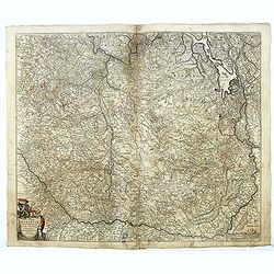
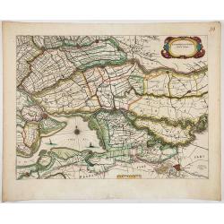
Comitatus Zutphania.
With an inset a plan of the town of Zutphen. Originally published by Petrus Kaerius in 1617. Published by Visscher in his "Belgium sive Germania Inferior continens p...
Place & Date: Amsterdam, 1634
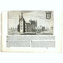
![Lovenstein. [Loevestein]](/uploads/cache/13749-250x250.jpg)
Lovenstein. [Loevestein]
View of the castle Loevestein, near Gorinchem.. On the sky, three hands holding a quill, a stone and a stick are depicted. With a verse in two languages underneath the pi...
- $60 / ≈ €56
Place & Date: Frankfurt, 1624
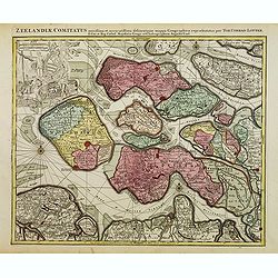
(Zeeland)
Rare map of Zeeland, first issued by Petrus Kaerius, than by Claes Jansz. Visscher. The copper plate was previously made by an anonymous engraver, and than came into the ...
- $1050 / ≈ €983
Place & Date: Amsterdam, 1631
Provincia ecclesiastica di Utrecht Nell' Olanda (Tav LXIII)
This large-format map of The Netherlands with its different dioceses. The map is finely engraved and beautifully colored and was prepared by Girolamo Petri, a lawyer who ...
- $250 / ≈ €234
Place & Date: Rome, 1858

A new mape of Ye XVII Provinces of Low Germanie.
Showing all 17 Provinces of the Netherlands before the split between Spain and the Protestant Provinces under the House of Orange. The map was published while the war of ...
- $2300 / ≈ €2152
Place & Date: London, George Humble, 1626 [1627
![Flessingue Ville de l'Ile de Walcheren. [Vlissingen]](/uploads/cache/13105-250x250.jpg)
Flessingue Ville de l'Ile de Walcheren. [Vlissingen]
A very RARE panoramic view of the city of Vlissingen. The plate is numbered in red pencil in the upper right corner.Engraved by Jean Crepy (the father), who was active as...
- $400 / ≈ €374
Place & Date: Paris, 1690-1720
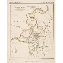
Gemeente Roermond.
From: J.Kuyper Gemeente-Atlas van Nederland naar officieele bronnen bewerkt. He was one of the most important of the Dutch atlas editors of the second half of the 19th ce...
- $90 / ≈ €84
Place & Date: Leeuwarden 1867
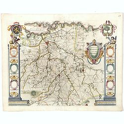
Brabantia Ducatus.
West is at the top. On the lower left a magnificent cartouche with a sitting female figure carrying a globe and compasses and the coat of arms of Brabant. Like all other ...
- $500 / ≈ €468
Place & Date: Amsterdam, 1650
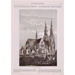
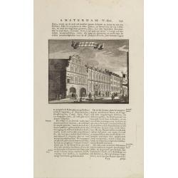
Sint Catharinakerk te Eindhoven
Uncommon print of St.Catharina church of Eindhoven, built by the well-known architect P.Cuijpers. Published in Katholieke Illustratie .
- $85 / ≈ €80
Place & Date: 'sHertogenbosch, 1880
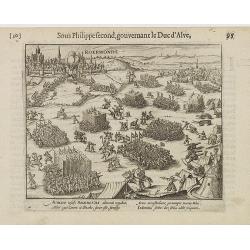
Auriaco infaelix Roermonda. . .
Showing the siege in May 1572 of Roermond.
- $100 / ≈ €94
Place & Date: Amsterdam, 1612
Novissima et Accuratissima Brabantiae Ducatus Tabula.
North is to the right. Like all other maps of Brabantiae Ducatus, it encloses the area between the rivers Rhine, Maas and Schelde, with Namur as the most southern town. O...
- $350 / ≈ €328
Place & Date: Amsterdam, 1629
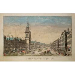
De Maria kerk te Leiden.
In the eighteenth and nineteenth centuries, there were many popular speciality establishments in Paris, Augsburg and London that produced optical viewing devices and spec...
- $200 / ≈ €187
Place & Date: Paris, 1760
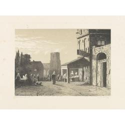
Den Briel.
Attractive lithography showing a typical Dutch street scene of Den Briel in the middle of the 19th century, lithographed by A.C.Cramer after a painting by Cornelis Spring...
- $50 / ≈ €47
Place & Date: The Hague, 1869
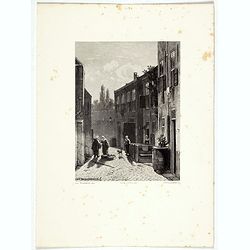
Dutch street scene.
Attractive lithography showing a Dutch street scene, lithographed by F.H. Weissenbruch after a painting of Jan Weissenbruch.
- $50 / ≈ €47
Place & Date: The Hague, 1850
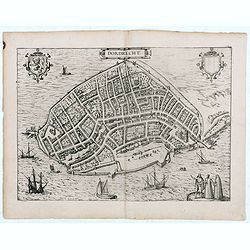
Dordrecht.
Very desirable and early town-plan of Dordrecht.From volume one of the greatest publication in this genre!. The Civitates was compiled and written by George Braun, Canon ...
- $200 / ≈ €187
Place & Date: Cologne, 1575
![Matelot Hollandais [Dutch sailor]](/uploads/cache/28927-250x250.jpg)
Matelot Hollandais [Dutch sailor]
Etching showing a typical Dutch sailor, after Jacques Grasset de Saint-Sauveur (1757–1810). Taken from "Costumes Civils actuels de tous les peuples connus, dessin�...
- $80 / ≈ €75
Place & Date: Paris, Pavard, 1788

Belgium Foederatum auctius et emendatius edit..
Map of the northern part of the Netherlands. With a decorative title cartouche, with an inset map of South East Asia.
- $500 / ≈ €468
Place & Date: Augsburg, 1760

Kaerte van Bergen op Zoom, Steenbergen ende de nieuwe fortificatien gemaeckt tot bevrÿdinge van 't landt van ter Tolen in tjaar 1628.
Very detailed and scarce map showing Bergen Op Zoom, Steenbergen and its surrounding countryside. North to the left side.
- $400 / ≈ €374
Place & Date: Amsterdam, after 1628
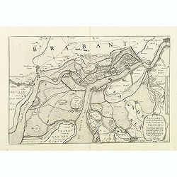
Pas-Caert vande ghelegetheyt vande Schans te Santvliet, Vertoonede de verdroncken overwaeterde Landen, nieuw aengewasse gorsingen,. . .
Showing the surrounding countryside of the cities of Antwerp, Santvliet, Lillo, Bergen op zoom, etc. The map is ponctuated by several fortifications to indicate the main ...
- $400 / ≈ €374
Place & Date: Amsterdam, 1630
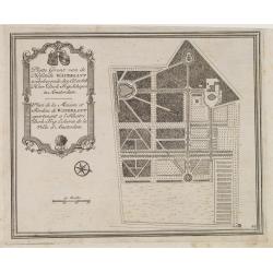
Platte Gront van de Hofstede Waterlant toebehorende den Ed. Achtb. Heer Dirk Trip Schepen te Amsterdam.
Uncommon plan of Hofstede Waterlant. Published in Hollandsche Arcadia. Title in Dutch and French "Plan de la Maison et Jardins appartenant a l'Illustre Dirk Trip Ech...
- $40 / ≈ €37
Place & Date: Amsterdam, 1740
Gemete Kaerte van de Stede Beverwyk, zoo als die tegenwoordigh zich vertoont.
Uncommon plan of Beverwijk made in the year 1739. Published in Hollandsche Arcadia. Title in Dutch and French.
- $75 / ≈ €70
Place & Date: Amsterdam, ca.1740

De Texel Stroom .. vant Marsdiep./ Caarte van De Mase...
Two decorative charts on one sheet, one depicting Texel and the entrance of the Zuider Zee with an inset showing the north coast of West-Friesland, the other depicting th...
- $750 / ≈ €702
Place & Date: Amsterdam, 1660
t'Oost-Indisch-Huys.
A decorative print of the East Indian House, the headquarters of the V.O.C., a place for meeting, trading and storage of spices and ship equipment. The maps and charts we...
- $150 / ≈ €140
Place & Date: Amsterdam, 1760-1767
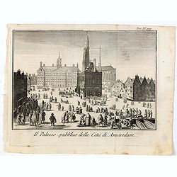
Il Palazzo pubblico della Citta di Amsterdam.
Fine panoramic views of the Dam square in Amsterdam, taken from Storia moderna di tutti I popoli del mondo , edited by Thomas Salmon. A Italian edition of this famous wor...
- $75 / ≈ €70
Place & Date: Venice, 1740-1756
DESCRIPTION DE TOUT LE PAIS BAS Autrement dict La Germanie Inferieure, ou Basse-Allemaigne…
First French edition. Illustrated with a coat of arms and portrait of Philips II, with a folding map of The Netherlands and maps and views of Brabant, Louvain, Brussel, A...
- $4500 / ≈ €4211
Place & Date: Anvers. Guillaume Silvius, 1567
![Description de tovts les Pays-Bas, autrement appellez, la Germanie Inferieure, ov Basse Allemagne / par Messire Loys Gvicciardin [...]](/uploads/cache/48781-250x250.jpg)
Description de tovts les Pays-Bas, autrement appellez, la Germanie Inferieure, ov Basse Allemagne / par Messire Loys Gvicciardin [...]
Fine early edition of the French oblong edition of this famous description of the Low Countries. For the French edition most plates are newly engraved by Petrus Kaerius.....
- $3500 / ≈ €3275
Place & Date: Arnhem, Janssonius, J.,1613
Zeelandiae Comitatus. . .
Scarce map of Zeeland, this is the state published by Tobias Conrad Lotter, previously published by Matthäus Seutter.Impressive cartouche with coat of arms of Zeeland to...
- $400 / ≈ €374
Place & Date: Augsburg, c.1760
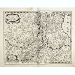
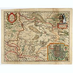
Ducatus Geldriae novissima. . .
Early map of Gelderland, but also including Utrecht, and parts of Brabant. Shows many cities (like Nijmegen, Eindhoven, Zutphen, Zwolle, etc), roads, rivers, woods, regio...
- $350 / ≈ €328
Place & Date: Amsterdam, 1629-1630
Chorographie des Pays Bas Hollandois et Autrichiens. . .
Fine detailed and uncommon map of the modern Netherlands, Belgium and Luxembourg. Prepared by Etienne André Philippe de Pretot (1708-1787) after sources according to the...
- $200 / ≈ €187
Place & Date: Paris, 1772
Septendecm. Provinciae Germaniae Inferior. . .
A general map of the Netherlands, Luxembourg and Belgium. Fine title cartouche showing Mercury, Neptune, globe, etc. Lower right coat of arms of 17 Provinces.
- $225 / ≈ €211
Place & Date: Amsterdam, 1700
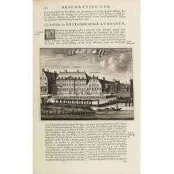
s'Lands en Oost-Indische Lynbanen.
A decorative print of the Lynbanen a place were V.O.C. ship riggings and ropes were produced and kept.From J.Wagenaar: Amsterdam in zijne opkomst, aanwas, geschiedenisse....
- $100 / ≈ €94
Place & Date: Amsterdam, 1760-1767
Duché de Brabant et ses Annexes . . .
Scarce and detailed map of the duchy of Brabant now divided between Belgium and the Netherlands. Dated 1668. A later edition with the date 1676 also exists.More about Pie...
- $300 / ≈ €281
Place & Date: Paris, 1665
Descriptio Germaniae Inferioris.
The oval map is surrounded by a strapwork frame and the title, adorned with ribbons, is held aloft by two winged cherubs.According to P. Meurer based on de Jode's 12 shee...
- $550 / ≈ €515
Place & Date: Antwerp, 1587
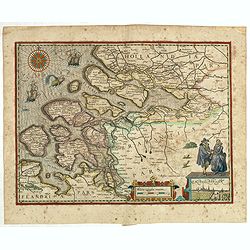
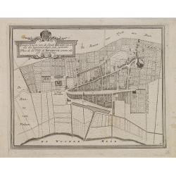
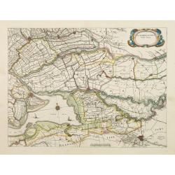
Zuydhollandia stricte sumta.
The count ship of Holland was subdivided into a number of bailiwicks. The most southerly bailiwick, bordering on Brabant was named Zuid-Holland. Many floods changed the a...
- $350 / ≈ €328
Place & Date: Amsterdam, 1645

Transisalania vulgo Over-Yssel auct. N. ten Have. . .
Map of the central part of the Netherlands, prepared by N. ten Have with a decorative cartouche lower left.Joachim Ottens (1663 - 1719) and his sons Renier and Joshua wer...
- $225 / ≈ €211
Place & Date: Amsterdam, ca. 1750
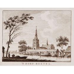
't dorp Boxtel.
Rare print of a view on the town of Boxtel (near Eindhoven), from Vaderlandsche gezichten of afbeeldingen.. by J.Bulthuis, printed by H.Gartman in Amsterdam.
- $150 / ≈ €140
Place & Date: Amsterdam, 1786-1792
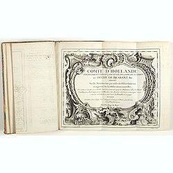
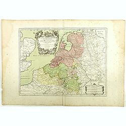
Comté d'Hollande, seigneurie d'Utrecht, comtés de Zelande, de Zutphen et duché de Brabant &c. Dressés sur les Mémoires faits par ordre des Estats Généraux et augmentés sur les Observations nouvelles.
Pocket atlas illustrated with a folded engraved title, a general map and 34 folded maps, including maps of the Netherlands, Belgium and parts of Germany.Provenance : Ex-l...
- $2400 / ≈ €2246
Place & Date: Paris, Crépy, ca. 1748
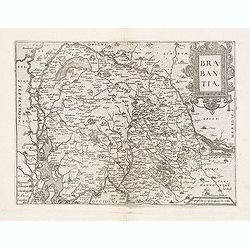
Brabantia.
Map of Brabant from Guicciardini's "Description de touts les Pais-Bais" edited by Plantin in 1582. The map drawn after Ortelius' map of Brabant, and after the l...
- $275 / ≈ €257
Place & Date: Antwerp, 1582
La Boucherie de Haarlem.
Uncommon and decorative lithography of "het slachthuis" in Haarlem, published by Carl Johan Billmark and printed by Lemercier in Paris, 55 rue de Seine, the lea...
- $50 / ≈ €47
Place & Date: Paris, c.1859
Dordrecht.
Attractive lithography showing a Dutch street scene, printed by C.W.Mieling and lithographed by Jan Weissenbruch. Published in Kunst Kroniek .
- $50 / ≈ €47
Place & Date: The Hague 1850
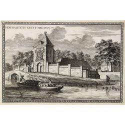
Generaliteits Kruyt-Magasyn.
The print depicts the gunpowder storage in Rotterdam. A most decorative item.
- $50 / ≈ €47
Place & Date: Amsterdam, 1703
Brabantia.
Decorative regional map of northern Belgium and the Dutch province Brabant, extending north to Breda and south to Namur, with Antwerp and Brussels near the center.Oriente...
- $150 / ≈ €140
Place & Date: Amsterdam, 1608
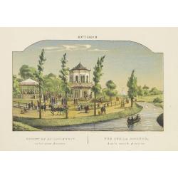
ROTTERDAM Gezigt op de Societeit in het nieuwe. . .
Decorative view of the society of Rotterdam. Decorated with personages in typical dress watching a concert.
- $75 / ≈ €70
Place & Date: Amsterdam, 1860
ROTTERDAM De beurs - La Bourse.
Decorative view of the exchange of Rotterdam. Printed by the master printer François Buffa of Amsterdam.
- $75 / ≈ €70
Place & Date: Amsterdam, 1860
The Hague
Attractive lithography showing a street scene in The Hague. Lithographed by Jan Weissenbruch, published by K.Fuhri, included in Kunst Kroniek.
- $40 / ≈ €37
Place & Date: The Hague, 1848
Arnhem
Attractive lithography showing a street scene in Arnhem. Lithographed by Jan Weissenbruch, published by C.W. Mieling, included in Kunst Kroniek.
- $65 / ≈ €61
Place & Date: The Hague, 1851
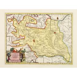
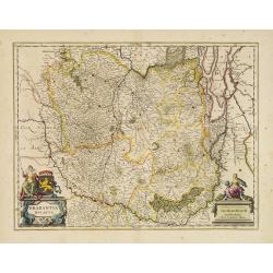
Le Limbourg ou font le duche de Limbourg. . .
Fine map of the Limburg with a decorative title and scale cartouche.Alexis-Hubert Jaillot (1632-1712), was a French cartographer. He joined the Sanson heirs and redrew Ni...
- $200 / ≈ €187
Place & Date: Amsterdam, 1692
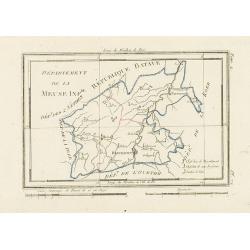
Département de la Meuse Inf.re.
Map representing the area around Maastricht, with a short key list in the lower right corner.From Atlas de la Géographie de toutes les parties du monde .. Ouvrage destin...
- $40 / ≈ €37
Place & Date: Paris, Prudhomme, Levrault, Debray, 1806
Prospectus Castelli Boxmerce / Prospectus Castelli Asten.
Early view of the castle of Boxmeer, engraved by H. Causé after a design by J. van Croes and published in "Vermakelykheden van Brabant en deszelfs onderhoorige land...
- $35 / ≈ €33
Place & Date: Amsterdam, 1696
Les Dix-Sept Provinces des Pays-Bas. . .
Map of the present-day Benelux by L.C. Desnos. Engraved by Cordier.
- $100 / ≈ €94
Place & Date: Paris, 1784
![[France - The Netherlands - Belgium].](/uploads/cache/46168-250x250.jpg)
[France - The Netherlands - Belgium].
Alexey Afinogenovich Ilyin was a lieutenant general and cartographer (1832-1889). In 1856, after graduating from the Academy of the General Staff, he was at the military ...
- $50 / ≈ €47
Place & Date: St. Petersburg, 1899
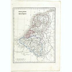
Hollande et Belgique.
Detailed Holland and Belgium map, prepared by Charles V. Monin (fl.1830-1880) a French cartographer of Caen and Paris. Published in Atlas Universel de Géographie Ancienn...
- $50 / ≈ €47
Place & Date: Paris, 1845
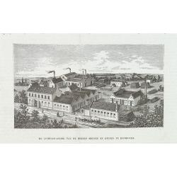
De luciferfabriek van de Heeren Mennen en Krunen te Eindhoven.
Wood engraving published in "Katholieke Illustratie", showing the match factories of Mennnen en Krunen in Eindhoven. Founded in 1870 by banker Christiaan Mennen...
- $40 / ≈ €37
Place & Date: s-Hertogenbosch, H.Bogaerts, ca. 1885
![Sint-Catharinakerk te Eindhoven [with plan]](/uploads/cache/28813-250x250.jpg)
Sint-Catharinakerk te Eindhoven [with plan]
Uncommon wood engraved print of St.Catharina church in Eindhoven, built by the well-known architect P.Cuijpers. Published in Kunstkronijk. This wood engraving is similar ...
- $85 / ≈ €80
Place & Date: Amsterdam, c.1880
s'Lants Zee-Magazyn en Scheeps Timmer-werf.
Decorative view of the back yard formerly the V.O.C. warehouse and arsenal for the Admiralty of Amsterdam, now-a-days the Scheepvaartmuseum (Maritime Museum).The print is...
- $250 / ≈ €234
Place & Date: Amsterdam, 1694
Le Brabant. Ou la Campagne du Roy de 1746. . .
Uncommon map of Dutch and Belgium Brabant by George Louis Le Rouge, who was active from 1740- till 1780 as a publisher and was appointed engineer for the King of France.D...
- $300 / ≈ €281
Place & Date: Paris, ca. 1750
Zuydhollandia stricte sumta.
The count ship of Holland was subdivided into a number of bailiwicks. The most southerly bailiwick, bordering on Brabant was named Zuid-Holland. Many floods changed the a...
- $400 / ≈ €374
Place & Date: Amsterdam, 1645
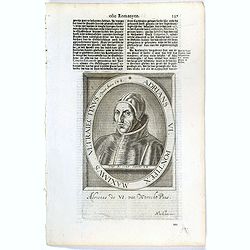
Adrians VI. Pontifex Maximus Ultraiectinus Vixit Annos 64 1/2.
The engraving depicts a half length oval portrait of Pope Adrian VI, born Adriaan Florensz (Boeyens) (1459 ? 1523), was born in the Prince-Bishopric of Utrecht in the Net...
- $25 / ≈ €23
Place & Date: Amsterdam, Cloppenburch, 1621
Carte du Brabant, suivant les Nouvelles Observations de Messrs de L'Academie Royale des Sciences etc. . .
Although not renowned for the originality of his work, Pieter van der Aa is highly thought of for the design and quality of his output. Showing the present-day Dutch and ...
- $300 / ≈ €281
Place & Date: Amsterdam, 1713
Karta öfver Nederland. / Karta öfver Danmark.
An very rare map of The Low Countries and Denmark with Swedish text. This is an updated version of his map of 1820 and is now dated 1832.From his atlas "Geographisk ...
- $110 / ≈ €103
Place & Date: A. Wiborgs förlag, Stockholm, ca. 1848
Tabula ducatus Limburch et comitatus Valckenburch. . .
The map describes the southern part of Limburg and reaches into Belgium (Liége, Verviers) and Germany. With two very decorative cartouches.
- $250 / ≈ €234
Place & Date: Amsterdam, 1690

Nouvelle et exacte Carte du Duche de Brabant. . .
A very rare example of a map of the duchy of Brabant. Title cartouche in the lower left-hand corner. A very rare issue of this map of Brabant. Cornelis Danckerts II. copi...
- $800 / ≈ €749
Place & Date: Amsterdam, 1635
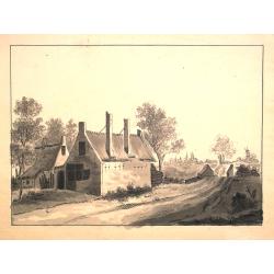
Dutch landscape.
Finely executed water color in pen and ink and gray wash color. Showing a Dutch landscape with farm house and windmills on the horizon.
- $60 / ≈ €56
Place & Date: Probably The Netherlands, ca. 1800

Die Republic Holland oder die Verenigte Niederlande..
Charming map of the Netherlands, with inset maps of Novi Belgium area in America and Indonesia. With a fine cartouche.
- $250 / ≈ €234
Place & Date: Leipzig 1749
Partie Septentrionale des Pays Bas..
"Detailed map covering the Low Countries, published by Jean Latré."
- $400 / ≈ €374
Place & Date: Paris 1760
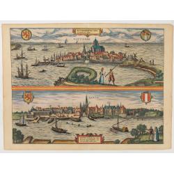
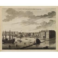
Roterodamum.. (Rotterdam) / Gouda.
One of the oldest panoramic views of the cities of Gouda and Rotterdam.From the greatest publication in this genre !. The ,Civitates, was compiled and written by George B...
- $500 / ≈ €468
Place & Date: Cologne 1580
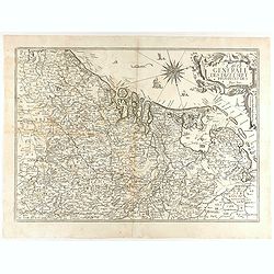
Carte Generale des Dixet Sept Provinces des Pays Bas.
Rare map of the Low Countries, including Belgium, the Netherlands and Luxembourg after Tassin and offered for sale by the publisher N. Berey.
- $750 / ≈ €702
Place & Date: Paris, 1634