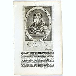
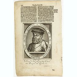
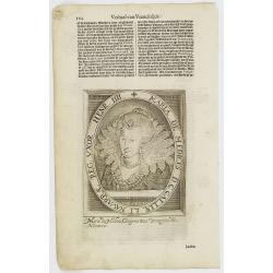
Leo X. Pontifex Maximus Florentinus Sedit Annos 8 Menses 8. / Paulus Quartus Neapolitanus Pontifex Maximus..
The engraving depicts a half length oval portrait of the Pope "Leo X", signed lower right corner N. de Cleck".On verso a half length oval portrait of "...
- $15 / ≈ €14
Place & Date: Amsterdam, Cloppenburch, 1621

Fredeicus II. EXVL, Rex eapoltanus XXI.
The engraving depicts a half length oval portrait of "Fredericus II" and on the verso a portrait of "Ferdinandus V".Nicolaes de Clerck (de Klerc) was ...
- $20 / ≈ €19
Place & Date: Amsterdam, Cloppenburch, 1621
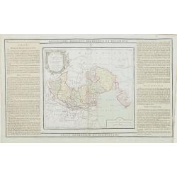
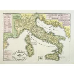
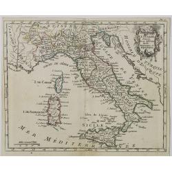
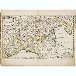
L'Etat de Venise et le Duché de Mantoue..
Attractive map covering the region centered on today region Veneto and its chief town Venice.Extending westwards to include part of Lombardy and eastward to Trieste and I...
- $100 / ≈ €94
Place & Date: Paris, 1790
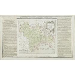
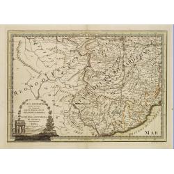
Partie de l' Italie, comprenant les Etats du Roy de Sardaigne. . .
Decorative map of northwest Italy and the Golfo di Genova. With ornamental title cartouche.Flanked by two columns of French text containing geographical information about...
- $100 / ≈ €94
Place & Date: Paris, 1790
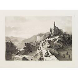
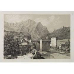
Sigmundskron (Tyrol, près de Bolzan).
Uncommon and decorative lithography published by Carl Johan Billmark and printed by Lemercier in Paris, 55 rue de Seine, the leading firm in Europe at that time. From: It...
- $60 / ≈ €56
Place & Date: Paris, c.1859
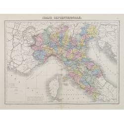
Italie Septentrionale.
A decorative map of northern Italy from Géographie Universelle, Atlas Migeon, published by J. Migeon.From one of the last decorative atlases published in the 19th centur...
- $25 / ≈ €23
Place & Date: Paris, 1874
Ionnes III. D. G. Portugaliae Algarbiae etc. Rex. Decimus- Quintus / Fredeicus. II. Exul, Rex Neapolitanus XXI.
The engraving depicts a half length oval portrait of Naples King Fredericus. II and Portuguese King Iohannes III..Nicolaes de Clerck (de Klerc) was active as engraver and...
- $45 / ≈ €42
Place & Date: Amsterdam, Cloppenburch, 1621
![[Title page] Album delle principali vedute di Venezia disegnate da Marco Moro. . .](/uploads/cache/32269-250x250.jpg)
[Title page] Album delle principali vedute di Venezia disegnate da Marco Moro. . .
Title page with a virgin and the lion of saint Mark sitting on an island with in the background the town of Venice.
- $65 / ≈ €61
Place & Date: Venice, G. Brizeghel, ca 1860
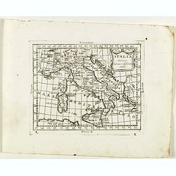
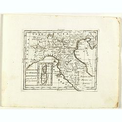
Italia divisa né suoi differenti stati.
Rare map of Italy, Sardinia and Corsica from "Atlante Novissimo ad uso Dei Giovani Studiosi Contenuto In Carte XXVII.", published by Giovanni Zempel in Rome, ca...
- $50 / ≈ €47
Place & Date: Rome, 1780
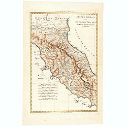
Etat de l'Eglise et Duché de Toscane.
Map of central Italy with Tuscany region by Rigobert Bonne.
- $75 / ≈ €70
Place & Date: Paris, 1771
Pont du Crevola au pied de Simplon (Italie).
Uncommon and picturesque lithography of the Crevola Bridge at the foot of the Simplon Mountain in Italy. Published by Carl Johan Billmark and printed by Lemercier in Pari...
Place & Date: Paris, ca.1859
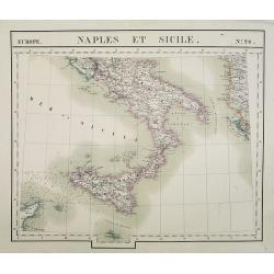
Europe. Naples et Sicile. N.26.
Detailed map including lower half of Italy with the island of Sicily.From his famous Atlas Universel . This atlas was one of the most remarkable world atlases ever produc...
Place & Date: Brussels, 1825-1827

Les Trois Temples de Pestum. Royaume de Naples.
Uncommon and decorative lithography of the Temples of Paestum near Naples. Published by Carl Johan Billmark and printed by Lemercier in Paris, 55 rue de Seine, the leadin...
Place & Date: Paris, c.1859
Maria De Medices D. G Galliae et Navarrae Reg. Uxor Henr. IIII.
The engraving depicts a half length oval portrait of Marie de' Medici, queen consort of France .Nicolaes de Clerck (de Klerc) was active as engraver and publisher in Delf...
Place & Date: Amsterdam, Cloppenburch, 1621

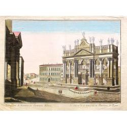
Rome. Les Trois colonnes de Grecostatis, et le Forum Romanum.
Uncommon and picturesque lithography of the Forum Romanum in Rome. On foreground the remains of the Temple of Castor and Pollux.Published by Carl Johan Billmark and print...
Place & Date: Paris, c.1859

La Rue des Tombeaux à Pompeia.
Uncommon and decorative lithography published by Carl Johan Billmark and printed by Lemercier in Paris, 55 rue de Seine, the leading firm in Europe at that time. From: ...
- $80 / ≈ €75
Place & Date: Paris, c.1859
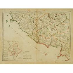
Regionum Italiae mediarum Tabula Geographica. . .
Fine historical map of central Italy with Tuscany, centered on Rome, in the south Pompeii, in the top the island of Giglio and the town Orbetello. Lower left inset plan o...
- $150 / ≈ €140
Place & Date: Paris, 1745
![[Lake Garda and its surroundings].](/uploads/cache/46166-250x250.jpg)
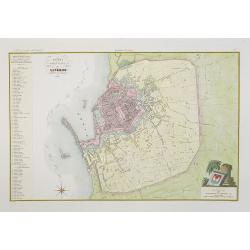
[Lake Garda and its surroundings].
Alexey Afinogenovich Ilyin was a lieutenant general and cartographer (1832-1889). In 1856, after graduating from the Academy of the General Staff, he was at the military ...
- $100 / ≈ €94
Place & Date: St. Petersburg, 1899
L'Italia antica-romana.
A rare and detailed double-page map of ancient Italy. According to the title cartouche, prepared by A de La Sage for l'Atlante Storico, Letterario, Biografico, Archeologi...
Place & Date: Venice, 1840

Combat de Palestro.
Showing the battle of Palestro lithographed by E.S. Walter and printed by De Becquet and published by Rousselot in Paris.The lithograph is part of a series of prints publ...
- $100 / ≈ €94
Place & Date: Paris, ca. 1860
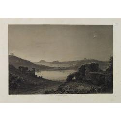
Lac d'Averne (Roye. De Naples).
Uncommon and picturesque lithography of the Lake Avernus (Lago d'Averno). It was believed to be the entrance to the underworld, and is portrayed as such in the Aeneid of ...
Place & Date: Paris, c.1859

Lac de Garda Vue prise à Teno.
Uncommon and picturesque view of the Garda lake from the town of Teno. Published by Carl Johan Billmark and printed by Lemercier in Paris, 55 rue de Seine, the leading fi...
Place & Date: Paris, c.1859

Rome (Ponte Rotto).
Uncommon and picturesque lithography of Rome with a view of the Rotto Bridge. Published by Carl Johan Billmark and printed by Lemercier in Paris, 55 rue de Seine, the lea...
Place & Date: Paris, c.1859

Lac de Nemi (environs de Rome).
Uncommon and picturesque lithography of Lake Nemi, a small circular volcanic lake in the Lazio region, 30 kilometers south of Rome. Published by Carl Johan Billmark and p...
Place & Date: Paris, c.1859
Portique d'Octavie à Rome.
Uncommon and decorative lithography of the Porticus Octaviae (portico of Octavia) in Rome. Published by Carl Johan Billmark and printed by Lemercier in Paris, 55 rue de S...
Place & Date: Paris, c.1859
Parte Occidentale del Regno Italico, Il Piemonte e Genovestato.
Rare map of Piemonte region in Italy, centered on Piemonte region, Genova and Milan, from "Atlante Novissimo ad uso Dei Giovani Studiosi Contenuto In Carte XXVII.&qu...
- $75 / ≈ €70
Place & Date: Rome, 1780
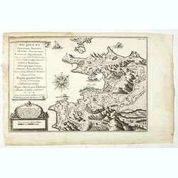
Hic Jacent Puteolorum Bajarum, Miseni Cumarium. . .
A bird's-eye view of Puzzoli and environs, depicting fascinating topographical and architectural features of interest. Title cartouche describes the map and area in Latin...
- $80 / ≈ €75
Place & Date: London, 1725-1744

Vue interieur de l'Eglise de S.Pierre de Rome.
So-called optical print of St. Pieter church of Rome. A well-known publisher of optical prints, established in Paris. In the eighteenth and nineteenth centuries there wer...
Place & Date: Paris, 1760

Vue des trois Gallerie, du Palais des Arts..Science a Rome.
So-called optical print. Daumont was a well-known publisher of optical prints, established in Paris. In the eighteenth and nineteenth centuries there were many popular sp...
Place & Date: Paris, 1760
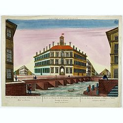
Prospect von Livorn. - Venduta del Palazo del Console D'Olanda in Venezia Nova in Livorne.
So called optical print published by Joseph Carmine showing the home of the Dutch consul in Livorno. Engraved after a design of Antonio Piemontesi. A well-known publisher...
- $100 / ≈ €94
Place & Date: Augsburg, ca. 1790
![VIII. Carte de l'Etat de Genes [. . .] Toscane.](/uploads/cache/24551-250x250.jpg)
VIII. Carte de l'Etat de Genes [. . .] Toscane.
Detailed small map showing an area straddling the provinces of Genoa, La Spezia, Parma and Massa Carrara, Tuscany.Relief shown pictorially. From Atlas Portatif Universel,...
Place & Date: Paris, later than 1748
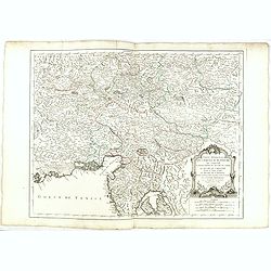
Partie Meridionale du Cercle d'Autriche qui comprend La basse partie du Duché de Strie, Le Duché de Carinthie, divisé en haute et basse, Le Duché de Carniole. . . Et l'Istrie Impériale. . .
Uncommon, finely and crisply engraved map with large decorative title cartouche.Very detailed sheet that is centered roughly on Trieste and extends in to the mouth of the...
- $100 / ≈ €94
Place & Date: Venice, 1784
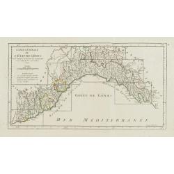
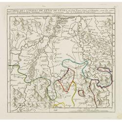
Carte Générale de l'Etat de Gênes.
Detailed map centered on the Gulf of Genoa. It shows the Italian region Liguria and extends westwards as far as Nice.Key map for the nine large-scale maps de Vaugondy mad...
- $100 / ≈ €94
Place & Date: Paris, ca. 1748

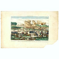
Bataille de Solferino. Pendant que ladivision Forey s'emparait du cimetiére et
Showing the battle of de Solfererino, in Italy. Lithographed by H.Jannin, rue des Bernardins, Paris.Underneath the print a explanation "Pendant que la division Forey...
- $100 / ≈ €94
Place & Date: Paris, ca. 1860
L'Italia Settentrionale presa da quella del Sig. Zannoni.
Rare map of Italy with inset map with Corsica and Sardinia, from "Atlante Novissimo ad uso Dei Giovani Studiosi Contenuto In Carte XXVII.", published by Giovann...
- $75 / ≈ €70
Place & Date: Rome, 1780
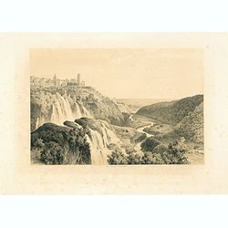
Cascatelles à Tivoli.
Uncommon and decorative lithography of the waterfalls near Tivoli.Published by Carl Johan Billmark and printed by Lemercier in Paris, 55 rue de Seine, the leading firm in...
- $100 / ≈ €94
Place & Date: Paris, c.1859
Carte d' Italie . . .
Map of Italy from Atlas moderne portatif composé de vingt-huit cartes sur toutes les parties du globe terrestre .. A l'usage des Colléges, des Pensions & des Maison...
Place & Date: Paris, Prudhomme, Levrault, Debray, 1806
L'alta Lombardia, Terzo Foglio Che comprende parte degli Stati del Re di Sardegna e parte della Repubblica di Genova.
Interesting map covering the border between France and Italy. In Nuovo Atlante Geografico Universale.
- $200 / ≈ €187
Place & Date: Rome, 1791
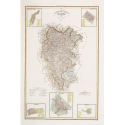
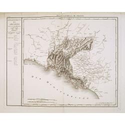
IV Compartimento Aretoni. . .
Very finely engraved and detailed map centered on Arezzo and Lago Trasimeno. Lower part three inset plans of Cortona, Arezzo and Chiusi. In upper corners plans of Montepu...
- $200 / ≈ €187
Place & Date: Rome, 1860
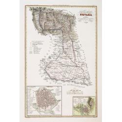
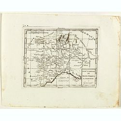
Divisione militaire di Novara. Provincie di Valsesia e di Vercelli.
Very finely engraved and detailed map centered on Vercelli and Varalio. Lower part two inset plans of Vercelli and Varallo and sacro Monte. Engraved by Pietro Manzoni and...
- $200 / ≈ €187
Place & Date: Rome, 1860
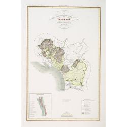
Compartimento Pisano.
Very finely engraved and detailed map of the territory of Pisa, including the region of Lucca and Estense. Lower left corner, an inset plan of Pontremoli. Lower right cor...
- $200 / ≈ €187
Place & Date: Rome, 1860
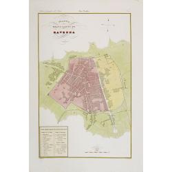
Pianta della citta di Ravenna.
Very finely engraved and detailed plan of Ravenna. Engraved by V.Angeli and included in: Atlante Geografico dell Italia. To the lower left a key to the principal building...
- $200 / ≈ €187
Place & Date: Rome, 1860
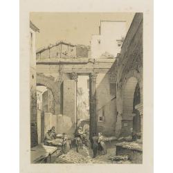
S. Maria della Spina (à Pise).
Uncommon lithography of the Church of S. Maria della Spina in Pisa. Published by Carl Johan Billmark and printed by Lemercier in Paris, 55 rue de Seine, the leading firm ...
Place & Date: Paris, c.1859
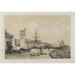
Savona Golfe de Gênes.
Uncommon and picturesque view of Sanova in the northern Italian region of Liguria in the Riviera di Ponente on the Mediterranean Sea. Published by Carl Johan Billmark and...
Place & Date: Paris, ca.1859
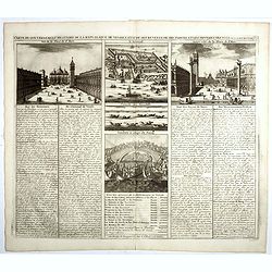
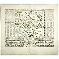
Carte du gouvernement militaire de la République de Venise . . .
Very decorative folio sheet with five engraved views in Venice: "Vue de la Palace de St. Marc" (Piazza San Marco), a birds-eye map of "L'Arcenal", &qu...
Place & Date: Amsterdam, 1720

Carte du Gouvernement Civil et Politique de la République de Venise . . .
This impressive engraving provides a detailed description of the infrastructure of the Venetian government.Ornamented with numerous vignettes illustrating sessions of par...
- $100 / ≈ €94
Place & Date: Amsterdam, 1720
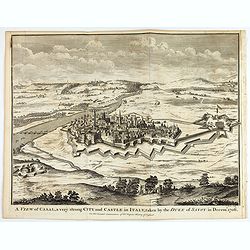
A view of Cassel, a very strong city in Italy, taken by the Duke of Savoy in Decem.r 1706
An interesting copper engraved plan of the Fortification of Cassel in Italy, with an attractive rococo cartouche, showing an overview of the battlefield and surrounding a...
Place & Date: London, 1743

Bataille sur la rive droite de la Brenta. gagnée par les Français de 22 fructidor an 4. Bonaparte Général en chef. . .
Uncommon optical print showing the siege of Bassano in 1795, during the French Revolutionary Wars, in the territory of the Republic of Venice, between a French army under...
- $150 / ≈ €140
Place & Date: Paris, ca. 1795

Subiaco. Environs de Rome.
Uncommon and picturesque view of Subiaco in the Province of Rome, in Lazio. Subiaco is famous as it was the first city in Italy where books were printed, in the 15th cent...
Place & Date: Paris, ca.1859

Eglise et place de Saint Andre dellavalle à Rome.
Perspective view of the church and place Sant'Andrea della Valle church in Rome. Sant'Andrea della Valle later became a model for the construction of other churches like ...
Place & Date: Paris, 1760

Rome. Vue prise du Mont Palatin.
Uncommon and picturesque lithography of Rome. View from Mount Palatin. Published by Carl Johan Billmark and printed by Lemercier in Paris, 55 rue de Seine, the leading fi...
Place & Date: Paris, c.1859
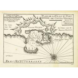
Plan de la Ville et Port de Civita-Vechia.
An attractive chart centered on Civitavecchia, a town and comune of the province of Rome in the central Italian region of Lazio.With scale and large compass-rose. Dated 1...
- $200 / ≈ €187
Place & Date: Marseille, 1730
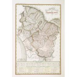
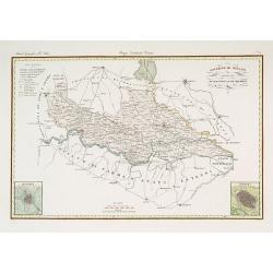
Governo di Venezia / Provincia di Udine.
Very finely engraved and detailed map of the area of Udine, with Trieste in lower right corner. Lower left corner an inset plan of Trieste : upper right corner, an inset ...
- $300 / ≈ €281
Place & Date: Rome, 1860

Maison de plaisance près de Parme.
So-called optical print of a country house near Parma, by the well-known publisher of optical prints, Basset, established in rue St.Jacques in Paris.In the eighteenth and...
- $150 / ≈ €140
Place & Date: Paris, 1760
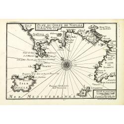
Plan du Golfe de Naples.
An attractive chart centered on the Gulf of Naples. Mount Vesuvius to the right. With scale and large compass-rose. Dated 1727, with the privilege of the King. From : Rec...
- $150 / ≈ €140
Place & Date: Marseille, 1730
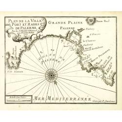
Plan de la Ville, Port et rades de Palerme. . .
An attractive chart centered on Palermo. With scale and large compass-rose. Dated 1727, with the privilege of the King. From : Recueil des Plusieurs plans des ports et ra...
- $250 / ≈ €234
Place & Date: Marseille, 1730
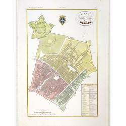
Pianta della citta di Modena.
Very finely engraved and detailed plan of Modena. Coat of arms of the town centred on the upper part. Engraved by V.Angeli and included in: Atlante Geografico dell Italia...
- $150 / ≈ €140
Place & Date: Rome, 1860
Bataille sur la rive droite de la Brenta. gagnée par les Francais de 22 fructidor an 4. Bonaparte Général en chef. . .
Uncommon print showing the siege of Bassano in 1795, during the French Revolutionary Wars, in the territory of the Republic of Venice, between a French army under Napoleo...
- $150 / ≈ €140
Place & Date: Paris, ca. 1795
VI. Carte des Confins de l'Etat de Gênes où sont Novi, Gavi, et Ottagio..
Detailed small map encompassing the part of Piedmont between Alessandria, Tortona and Novi Ligure.Relief shown pictorially. From Atlas Portatif Universel, by Robert de Va...
- $150 / ≈ €140
Place & Date: Paris, later than 1748
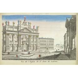
Vue de l'eglise de St Jean de Latran.
So-called optical print of the church Saint Jean de Latran, by Basset a well-known publisher of optical prints, established in rue St.Jacques in Paris. With brief key lis...
- $150 / ≈ €140
Place & Date: Paris, 1760
Tempum S.Joannis in Laterano Romae. . .
A so-called optical print. In the eighteenth and nineteenth centuries there were many popular specialty establishments in Paris, Augsburg and London which produced optica...
- $150 / ≈ €140
Place & Date: Italy, ca.1780
Pianta della citta di Livorno.
Very finely engraved and detailed plan of Livorno. Engraved by V.Angeli and included in: Atlante Geografico dell Italia . To the left, a key to the principal buildings a...
- $150 / ≈ €140
Place & Date: Rome, 1860
L'Italie dans son Premier Etablissement sous la Republique Romaine. . .
Map of Italy when first established under the Roman Republic after the division by Ayuguste Caesar, its various Papal governments: ancient Rome and its surround dings, a ...
Place & Date: Amsterdam, 1728
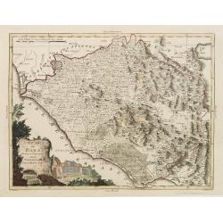
V. Compartimento Grossetano. . .
Very finely engraved and detailed map of Tuscany, centered on Grosseto. The island of Elba in left part.. In the corners insets of Sovana, Massa, Piombino, Orbetello and ...
- $200 / ≈ €187
Place & Date: Rome, 1860
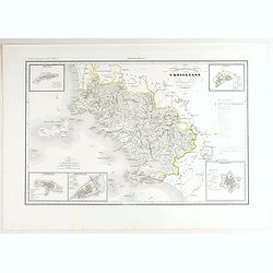
Ducato di Lucca.
Very finely engraved and detailed map of the region around Lucca. Lower part of the map, two inset lists of the mountains height and the local minerals. Engraved by Vetto...
- $200 / ≈ €187
Place & Date: Rome, 1860
Carta degla Stati Estensi avanti il domino dei Romani Sotto Il governo dei Medesimi.
Very finely engraved and detailed map of the Duchy of Lucca before the dominion of the Romans under the rule of the same and in the Middle AgesWith a key on the right par...
- $200 / ≈ €187
Place & Date: Rome, 1860
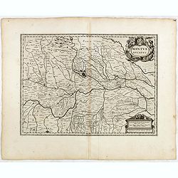
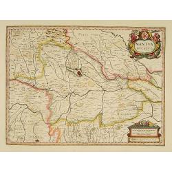
Mantua ducatus.
Originally engraved for Jodocus Hondius II, at his death in August 1629 this map was, among 39 other copper plates, purchased by Willem Blaeu who deleted Hondius' name an...
- $300 / ≈ €281
Place & Date: Amsterdam, 1634
Divisione Militare di Genova. Albenga / Savona.
Very finely engraved and detailed map covering the Mediterranean coast from Oneglia, Albenga, Noli until Savona. Upper corners, two inset plans of Savona and Albenga. Key...
- $150 / ≈ €140
Place & Date: Rome, 1860
Département des Apennins Divisé en 3 Arrondissemens et en 18 cantons.
Published in the "Atlas National de France" at Chanlaire. Engraved by P.A.F. Tardieu. Represents the department of Apennines which was under French administrati...
Place & Date: Paris, 1790-1811
Governo di Milano / Provincia di Mantova e Cremona.
Very finely engraved and detailed map centered on Mantua, including Cremona. Lower corners two inset plans of Mantua and Cremona. Upper left corner, a key. Engraved by Ve...
- $150 / ≈ €140
Place & Date: Rome, 1860

Quita Etas Mundi. Folium.LXVIII (Verona)
The Latin text page is illustrated with an imaginary of Verona, Italy. VERSO are portraits of poets and teachers.Page from the richest illustrated Incunable, the famous:...
Place & Date: Nuremberg, 12 July 1493
![[ View of Ragusi]](/uploads/cache/45206-250x250.jpg)
[ View of Ragusi]
Very rare view of Ragusa published in the first edition of "Viaggio da Venetia, a Costantinopoli. Per Mare, e per Terra, & infieme quello di Terra Santa. Da Gios...
Place & Date: Venice, Giacomo Franco, 1598
![[ View of Cruzola]](/uploads/cache/45205-250x250.jpg)
[ View of Cruzola]
Very rare view of Tremite Islands Island published in the first edition of "Viaggio da Venetia, a Costantinopoli. Per Mare, e per Terra, & infieme quello di Terr...
Place & Date: Venice, Giacomo Franco, 1598
Carte Générale de Lombardie.
Fine map of Northern and middle part of Italy, engraved by A Peyrouin. According to the credit in the cartouche the map has been prepared by Pierre Duval.
- $300 / ≈ €281
Place & Date: Paris, ca. 1650
Prospect der Gebäude beij der Realte in Venedig. - Vuës des Edifices du Realte de Venisi. (Buildings near Rialto Bridge in Venice)
Rare so-called optical print illustrating buildings close to the Ponte di Rialto (Rialto Bridge) in Venice. Engraved by Fredrich Leizelt after Joseph Baudin who was an im...
- $300 / ≈ €281
Place & Date: Augsburg, 1760
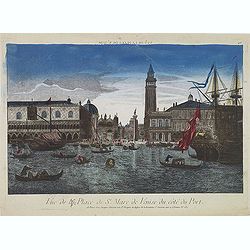
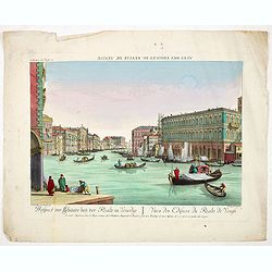
Vue de la Place de St Marc de Venise du côté du port.
Optical print showing the Doge's Palace (Palazzo Ducale), San Marco Square, and Saint Mark's Basilica (Basilica di San Marco in Venice, as seen from the waterside. The im...
- $150 / ≈ €140
Place & Date: Paris, ca. 1750
Campagna di Roma Di nuova Projezione. . .
A very striking map of the area south east of Rome, engraved by G.Pitteri embellished with an colored pictorial title cartouche.
Place & Date: Venice, 1798
Selling price: $200
Sold in 2015
Mantua ducatus.
Important map of northern Italy centered on the dramatic fortress of Mantua.
- $300 / ≈ €281
Place & Date: Amsterdam, 1635
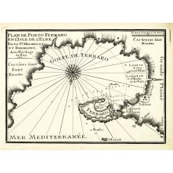
Plan de Porto Ferraro en l'isle de l'Elbe.
An attractive chart centered on the Mediterranean. With scale and large compass-rose. Dated 1727, with the privilege of the King. From : Recueil des Plusieurs plans des p...
- $200 / ≈ €187
Place & Date: Marseille, 1730
Compartimento Pisano.
Very finely engraved and detailed map centered on Pisa, including Livorno. Centered on the lower part, an inset plan of Pisa. Lower left corner, a key. Engraved by Vetto...
- $200 / ≈ €187
Place & Date: Rome, 1860