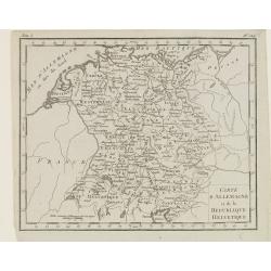
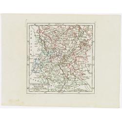
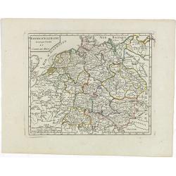
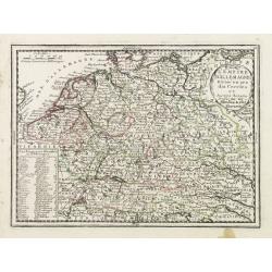
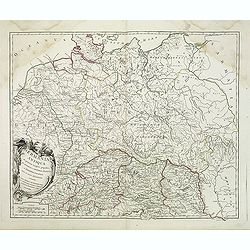
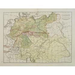
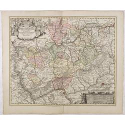
Carte d'Allemagne et de la Republique Helvetique.
Map of central Europe centered on Germany, extending southwards and eastwards to include Poland, the Czech Republic, Austria, Switzerland, Slovenia and part of Italy.From...
Place & Date: Paris, Prudhomme, Levrault, Debray, 1806
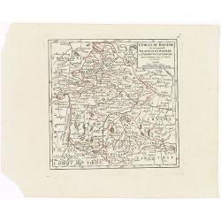
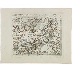
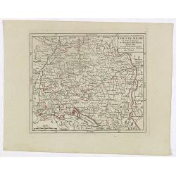
Cercle de Baviere où se trouvent le Palatinat de Baviere et l'Archev. De Saltzbourg.
Small detailed map of the southeastern part of Bavaria, including part of Austria. From Atlas Portatif Universel, by Robert de Vaugondy.Edited by : "Au dépôt de G�...
- $30 / ≈ €28
Place & Date: Paris, 1799
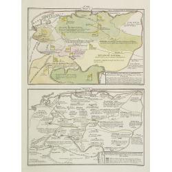
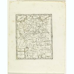
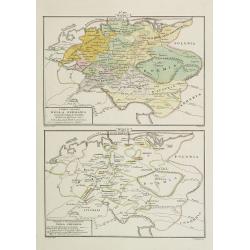
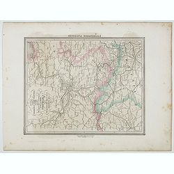
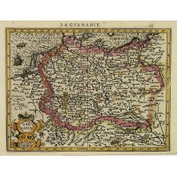
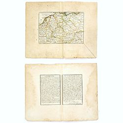
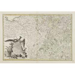
La Germania, suoi ducati e dependenze . . . /Origine e derivazione de principali stati . . .
Two rare maps of ancient Germany: Top map: 160 x 235mm. Bottom map: 160 x 235mm.Prepared by Las Casas for l'Atlante Storico, Letterario, Biografico, Archeologico. . . wi...
- $25 / ≈ €23
Place & Date: Venice, 1840
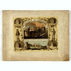
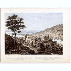
(Title page) Souvenir de Heidelberg.
Cover for a souvenir album with chromolithographed design and entitled: Souvenir de Heidelberg prepared by Louis Charles François. He emigrated with his family in May 17...
- $50 / ≈ €47
Place & Date: Graimberg, Heidelberg, ca. 1840
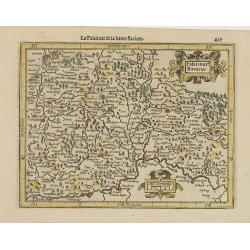
Cercle des quatre Electeurs.
Small detailed map of part of western Germany, centered on Frankfurt. From Atlas Portatif Universel, by Robert de Vaugondy.Edited by : "Au dépôt de Géographie, Ru...
- $25 / ≈ €23
Place & Date: Paris, 1799
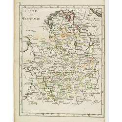
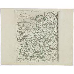
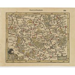
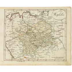
Cercle de Westphalie.
Fine map of North Rhine-Westphalia. George Louis Le Rouge was active from 1740 till 1780 as a publisher, and was appointed engineer for the King of France. From his Atlas...
- $30 / ≈ €28
Place & Date: Paris 1756
La Germania divisa ne' suoi differenti stati
Rare map of Germany, from "Atlante Novissimo ad uso Dei Giovani Studiosi Contenuto In Carte XXVII.", published by Giovanni Zempel in Rome, ca. 1780.The map is b...
- $25 / ≈ €23
Place & Date: Rome, 1780
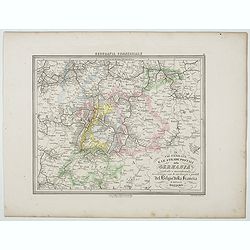
Le Vie Ferrate e le Strade Postali della Germania centrale e meridionale . . .
Uncommon map of Germany and part of France and Switzerland prepared by Francesco Costantino Marmocchi. Above the map "Geografia Commerciale". From "Il Glob...
- $25 / ≈ €23
Place & Date: Genova, Paolo Rivara fu Giacomo, 1858
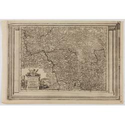
VII. Cours du Rhin où sont les environs de Philisbourg, Spire Landaw &c.
Small detailed map illustrating the stretch of the Rhine which flows between Germersheim and Speyer.From Atlas Portatif Universel, by Robert de Vaugondy. Edited by : &quo...
- $25 / ≈ €23
Place & Date: Paris, 1799
Le Marquisat et Electorat de Branderbourg.
Fine map of Brandenburg, with decorative title cartouche. George Louis Le Rouge was active from 1740- till 1780 as a publisher, and was appointed engineer for the King of...
- $30 / ≈ €28
Place & Date: Paris 1756
I dieci circoli Della Germania . . . / Permute e Secolarizzazioni Nella Germania . . .
Two rare maps of Germany: Top map: 160 x 235mm. Bottom map: 160 x 235mm.Prepared by Las Casas for l'Atlante Storico, Letterario, Biografico, Archeologico. . . with attri...
- $30 / ≈ €28
Place & Date: Venice, 1840
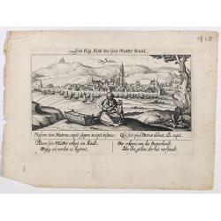
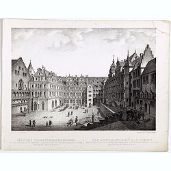
Sontra.
A panoramic view of the city Sontra in Hessen . With motto "ein klug Kind das sein Mutter kennt". On the foreground, a woman with two children and a crypt. With...
- $60 / ≈ €56
Place & Date: Frankfurt, 1623-1778
![Merla in Ob. Hessen. [Merlau]](/uploads/cache/13826-250x250.jpg)
Merla in Ob. Hessen. [Merlau]
A panoramic view of the castle and town of Merlau in Hessen. In the foreground, two men fighting each other are depicted. With a verse in two languages underneath the pic...
- $40 / ≈ €37
Place & Date: Frankfurt, 1623-1678
Le Vie Ferrate e le Strade Postali della Germania orientale . . .
Uncommon map of Germany and part of Poland, Hungary and Italy prepared by Francesco Costantino Marmocchi. Above the map "Geografia Commerciale". From "Il G...
- $25 / ≈ €23
Place & Date: Genova, Paolo Rivara fu Giacomo, 1858
L'Archeveché de Mayence, suivant les nouvelles observations..
With decorative title cartouche lower left corner. Including river Rhine. This example is unusual in having the additional separately engraved decorative framework border...
- $100 / ≈ €94
Place & Date: Amsterdam, 1728
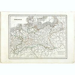
Prusse.
Detailed map of Prussia, prepared by Charles V. Monin (fl.1830-1880) a French cartographer of Caen and Paris. Published in Atlas Universel de Géographie Ancienne &c ...
- $40 / ≈ €37
Place & Date: Paris, 1845
Populorum Germaniae . . .
Two maps of historical Germany on a single sheet. The two maps appear identical at first glance, but actually are a comparison of the region during the reigns of differen...
- $50 / ≈ €47
Place & Date: Amsterdam, 1661
Empire d'Allemagne divisé par Cercles et Cours du Rhin.
Small detailed map of Germany, the Low Countries, Switzerland, Austria, Czechoslovakia and part of Poland.From Atlas Portatif Universel, by Robert de Vaugondy. Edited by ...
- $40 / ≈ €37
Place & Date: Paris, 1799
Cercle de Westphalie, divisé suivant ses différentes Principautés.
Small detailed map of the north western part of Germany, centred on Münster. From Atlas Portatif Universel, by Robert de Vaugondy.Edited by : "Au dépôt de Géogra...
- $30 / ≈ €28
Place & Date: Paris, 1799
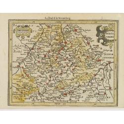
Wirtenberg.
Detailed map centered on Baden-Württemberg. With major cities of the area named.From the first French-text edition of Jodocus Hondius' Atlas Minor. Shortly after the p...
- $40 / ≈ €37
Place & Date: Amsterdam, 1608
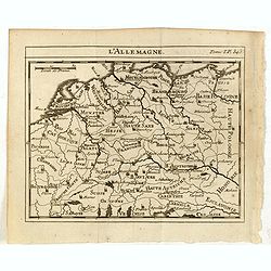
La Germanie.
Small map of Germany, including Austria and part of Poland. Strap work title cartouche in the lower left.From the first French-text edition of Jodocus Hondius' Atlas Mino...
- $75 / ≈ €70
Place & Date: Amsterdam, 1608
Nördlicher Theil des Heidelberg schlosses. Vue de la partie du nord du château de Heidelberg.
Early lithographs after Louis Charles François de Graimberg-Belleau. Lithographed by C.F Müller.French artist. Son of Gilles-François Belleau Graimberg. Louis Charles ...
Place & Date: Graimberg, Heidelberg, ca. 1840
Palatinat. Bavariae.
Detailed map showing part of Bavaria. It covers the area between Ingolstadt, Nuremberg and Regensburg.From the first French-text edition of Jodocus Hondius' Atlas Minor.S...
- $50 / ≈ €47
Place & Date: Amsterdam, 1608
L'Empire D'Allemagne Divisé en ses dix Cercles et Autres Estats..
Map centered on Germany, including Switzerland, Austria, part of France, Northern Italy and Eastern Europe. With title cartouche and a panel in the lower left corner list...
- $60 / ≈ €56
Place & Date: Paris 1719
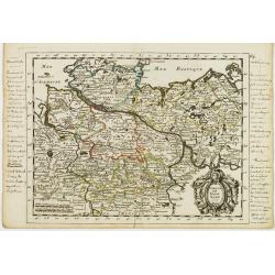
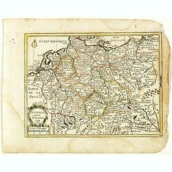
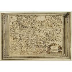
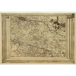
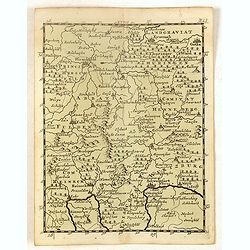
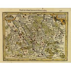
Cercle de la Basse Saxe, divisée par ses Principautés.
Small detailed map of the northern part of Germany. From Atlas Portatif Universel, by Robert de Vaugondy.Unrecorded state with erased date. Page 22 outside border top rig...
- $50 / ≈ €47
Place & Date: Paris, later than 1749
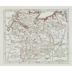
Cercle de Basse Saxe.
Fine map of Lower Saxony, with decorative title cartouche. With manuscript notes in left and right margins giving some historical information about the region. George Lou...
- $50 / ≈ €47
Place & Date: Paris, 1756
Brauswik et Meydburg com confinijs.
Detailed map showing the region around Brunswick and Magdeburg. With major cities of the area named.From the first French-text edition of Jodocus Hondius' Atlas Minor.Sho...
- $50 / ≈ €47
Place & Date: Amsterdam, 1608
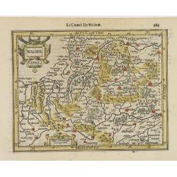
Waldek Comit.
Early map of the region surrounding Waldeck, northern Hessen. From the first French-text edition of Jodocus Hondius' Atlas Minor.Shortly after the publication of the big ...
- $45 / ≈ €42
Place & Date: Amsterdam, 1608
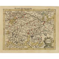
Bavaria.
Detailed map showing part of Bavaria. It covers the area between Ingolstadt and Salzburg.From the first French-text edition of Jodocus Hondius' Atlas Minor.Shortly after ...
- $50 / ≈ €47
Place & Date: Amsterdam, 1608
Westphalen.
Nice small map of Westphalia in Germany by Johannes Walch in his rare Allgemeiner Atlas Nach den bewährsten Hülfsmitteln und astronomischen Ortsbestimungen…, edition ...
- $50 / ≈ €47
Place & Date: Augsburg, 1812
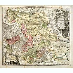
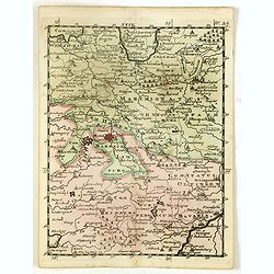
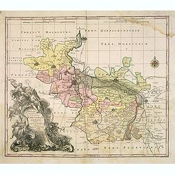
Cercles de Baviere et d'Autriche.
Map of the South east of Germany and Austria. By C. F. Delamarche, successor of Robert de Vaugondy, Geographer.
- $35 / ≈ €33
Place & Date: Paris, 1794 - 1806
Nouvelle Carte d'Allemagne 1651. (29).
Scarce map of Germany, Poland and the Low Countries, published by Antoine de Fer in 1661 or 1662 in "Cartes de géographie revues et augmentées". With number 2...
- $50 / ≈ €47
Place & Date: Paris, Antoine de Fer, 1657 but 1661 or 1662
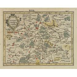
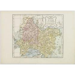
Hassia Landgraviatus.
Detailed map showing the region around Kassel. With major cities of the area named.From the first French-text edition of Jodocus Hondius' Atlas Minor.Shortly after the pu...
- $50 / ≈ €47
Place & Date: Amsterdam, 1608
Germania Antiqua. . .
A fine map of ancient Germany, Poland and the Netherlands from his "Atlas Universel".Gilles Robert de Vaugondy (1688–1766), also known as Le Sieur or Monsieur...
- $50 / ≈ €47
Place & Date: Paris, 1756
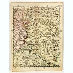
Principatus Halberstadiensis, abbat : Quedlinburgens cum Comitatu Wernigerodano, ad hodiernum verum statum ex acta prodiit ex officina geogr. . .
Detailed map showing principality Halberstadt, Abtei Quedlinburg and the county Wernigerode. Including the towns of Osterwieck, Stollberg, Aschersleben and Oschersleben.
Place & Date: Augsburg, 1750
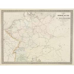
Carte des Chemins de Fer de l'Allemagne.
Fine map of Germany, The Netherlands and Eastern Europe, showing the early railway system of the area. From Atlas des Chemins de Fer published by Napoléon Chaix and pri...
Place & Date: Paris, 1863
Selling price: $2
Sold in 2011
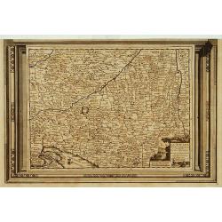
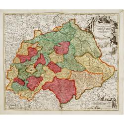
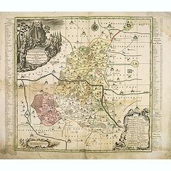
Cercle de Haute Saxe.
Finely and crisply engraved map of Germany, centered on Leipzig. From Atlas Universel printed in 1776-84.With ornamental title cartouche and noteworthy topographical deta...
- $75 / ≈ €70
Place & Date: Venice, 1776 - 1784

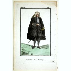
Femme d'Ausbourg.
Originally hand-colored mezzotint from 'Costumes civils actuels de tous les peuples connus'. After Jacques Grasset de Saint-Sauveur. As an etcher, drawer and writer, Gras...
- $50 / ≈ €47
Place & Date: Paris,1806
L'Allemagne divisée en dix cercles . . .
An interesting small map of Germany and Poland by Nicolas de Fer. From his rare "Petit et Nouveau Atlas". The first edition was published in 1697 and was republ...
- $75 / ≈ €70
Place & Date: Paris, 1704
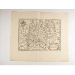
Erpach.
The town of Heidelberg is in most southern point on the map, including the rivers Rhine, Necker and Main.Rare issue published in Oxford. In 1680 the copper plates of Jans...
- $100 / ≈ €94
Place & Date: Oxford, 1680

Vue de la porte Charles. . . Ansicht ded Karlthors . . .
Early aquatint after Louis Charles François de Graimberg-Belleau. Engraved by J.J Tanner.French artist. Son of Gilles-François Belleau Graimberg. Louis Charles Françoi...
Place & Date: Graimberg, Heidelberg, ca. 1840
L'Alemagna . . .
A rare double-page map of Germany and Poland. Prepared by Las Casas and engraved by G.V.Pasquali for l'Atlante Storico, Letterario, Biografico, Archeologico. . . with at...
- $50 / ≈ €47
Place & Date: Venice, 1840
Praefecturae Principatus Querfurtensis Dahmiana et Iüterboccensis cum vicinia oppidis, vicis, pagis accurate distincta. . .
Showing the region of Ämter Dahme, Jüterbog, Baruth. With in the north Potsdam and in the south Schönwalde, in the west Brück/ Zahna and in the east Buchholz/ Luckau.
- $50 / ≈ €47
Place & Date: Augsburg, ca. 1740
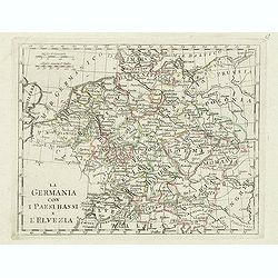
La germania con i paesi bassi e l'elvezia.
Charming map of Germany, Netherlands, Switzerland, Austria from the rare atlas Atlante Tascabile o sia Serie di Num. XXI Cartine Geografiche nelle quali si rappresenta in...
- $65 / ≈ €61
Place & Date: Rome, 1823
Cercle de Haute Saxe.
Finely and crisply engraved map of Germany, centered on Leipzig .Venetian edition of Giles Didier Robert De Vaugondy's map from Atlas Universel printed in 1776-84.Ornamen...
- $150 / ≈ €140
Place & Date: Venice, 1776 - 1784
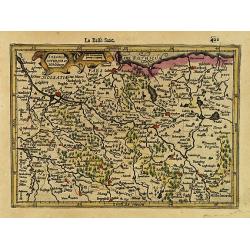
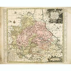
Cercle de la Basse Saxe, suivant les nouvelles observations..
Uncommon edition of this map of a province of Germany, including Hamburg, Bremen, etc. With decorative title cartouche lower right corner.This example is unusual in havin...
- $90 / ≈ €84
Place & Date: Amsterdam 1728
L'Allemagne.
Scarce small map of Germany, Poland and Low Countries based on cartography of Guillaume Delisle (. Published in "Nouveau traité de geographie par M**** ", publ...
- $50 / ≈ €47
Place & Date: Paris, 1752
Le Duché de Lunebourg, suivant les nouvelles observations?
Uncommon edition of this map of a province of Germany. With decorative title cartouche upper right corner.This example is unusual in having the additional separately engr...
- $80 / ≈ €75
Place & Date: Amsterdam, 1728
Saxonia Inferior et Mekleburg.
Detailed map showing part of northern Germany. With major cities of the area named.From the first French-text edition of Jodocus Hondius' Atlas Minor.Shortly after the pu...
- $80 / ≈ €75
Place & Date: Amsterdam, 1608
Estats de la Succession de Cleves/ Iuliers..
Fine map of western Germany.This edition carries the date 1650 and the publishers address A PARIS chez l'Autheur aux Galleries du Louvre. Nicolas Sanson was to bring abou...
- $60 / ≈ €56
Place & Date: Paris 1650
La Souabe meridionale, suivant les nouvelles observations..
Uncommon edition of this map of Southern Germany. With decorative title cartouche lower right corner.This example is unusual in having the additional separately engraved ...
- $90 / ≈ €84
Place & Date: Amsterdam 1728
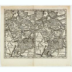
(Ochfenfurt, Hall, Bavaria, etc.)
Rare miniature map of Bavaria including the towns of Ochfenfurt, Hall, etc. From "Le theatre De Bellone, Contenant 48. nouvelles Cartes Geographiques, Des Païs-Bas ...
- $60 / ≈ €56
Place & Date: Amsterdam, 1710
(Schweinfurt, Reineck, Hirschfeld, etc.)
Rare miniature map including the towns of Schweinfurt, Reineck, Hirschfeld, etc. From "Le theatre De Bellone, Contenant 48. nouvelles Cartes Geographiques, Des Païs...
- $60 / ≈ €56
Place & Date: Amsterdam, 1710
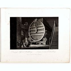
Das grofse Fafs au Heidelberg . Le gros tonneau de Heidelberg.
Engraving after Louis Charles François de Graimberg-Belleau. Engraved by J.J Tanner.French artist. Son of Gilles-François Belleau Graimberg. Louis Charles François emi...
Place & Date: Graimberg, Heidelberg, ca. 1840
Homme d'Ausbourg.
Originally hand-colored mezzotint from 'Costumes civils actuels de tous les peuples connus'. After Jacques Grasset de Saint-Sauveur. As an etcher, drawer and writer, Gras...
- $50 / ≈ €47
Place & Date: Paris,1806
(Hildesheim, Munden, Steinbrugge, Grubenhagen, etc.)
Rare miniature map including the towns of Hildesheim, Munden, Steinbrugge, Grubenhagen, etc. From "Le theatre De Bellone, Contenant 48. nouvelles Cartes Geographique...
- $60 / ≈ €56
Place & Date: Amsterdam, 1710
Cercle de Souabe où sont distingués les Enclaves de la Maison d'Autriche.
Small detailed map showing the state Baden-Württemberg, part of Bavaria and part of Austria.From Atlas Portatif Universel, by Robert de Vaugondy. Edited by : "Au d�...
- $70 / ≈ €66
Place & Date: Paris, 1799
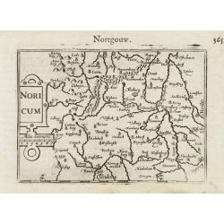
Noricum.
A miniature map showing a part of Bavaria, including the cities of Bamberg and Nuremberg. Title cartouche on the left side.First published in 1598 in his Caert-Thresoor, ...
- $50 / ≈ €47
Place & Date: Amsterdam / Frankfurt, 1609
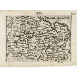
Hassiae Descriptio / Hesse.
A miniature map centered on the province of Hessen. The title cartouche on the upper right corner.First published in 1598 in his Caert-Thresoor, the plates were executed ...
- $50 / ≈ €47
Place & Date: Amsterdam / Frankfurt, 1609
Saxoniae Superioris Lusatiae..
Detailed map of Saxony. With Prague at the bottom. From the first French-text edition of Jodocus Hondius' Atlas Minor.Shortly after the publication of the big folio-atlas...
- $50 / ≈ €47
Place & Date: Amsterdam, 1608
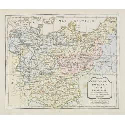
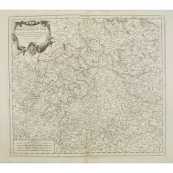
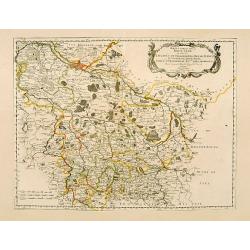
Cercle de Haute Saxe et de Basse Saxe. . .
Map of the duchies of Saxony (upper & lower). By C. F. Delamarche, successor of Robert de Vaugondy, Geographer.
- $50 / ≈ €47
Place & Date: Paris, 1794 - 1806
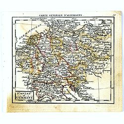
Empire of Germany.
Uncommon miniature map of Germany, Poland, the Low Countries and Eastern Europe, engraved by Thomas Kitching for "A New General and Universal Atlas Containing Forty ...
- $40 / ≈ €37
Place & Date: London, 1761-1763
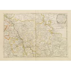
Electoratus saxonici praefecturae annaburgensis pretzschens torgaviensis schweinicensis. . .
Highly detailed map showing the regions of Annaburg, Pretzsch, Schweinitz in Sachsen-Anhalt, Torgau in Sachen and Mühlberg an der Elbe in Brandenburg. In the center of t...
- $60 / ≈ €56
Place & Date: Augsburg, 1750
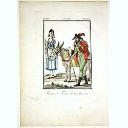
Homme & Femme de la Baviere.
Originally hand-colored mezzotint from 'Costumes civils actuels de tous les peuples connus'. Engraved by Félix Mixelle after Jacques Grasset de Saint-Sauveur.As an etche...
- $50 / ≈ €47
Place & Date: Paris,1806

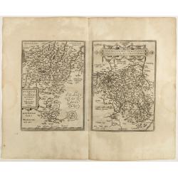
Cercle de Franconie.. Reineck d' Erpach.
Finely and crisply engraved map, centered on Schweinfurt, Bamberg and Nuremberg.Venetian edition of Giles Didier Robert De Vaugondy's map from Atlas Universel printed in ...
- $100 / ≈ €94
Place & Date: Venice, 1776 - 1784
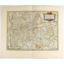
Monasteriensis Episcopatus.
A very detailed map of Germany centered on Linge. Showing Wessel to the top of the map, and Oldenburg to the right. North is oriented to the right. The map is further ado...
- $80 / ≈ €75
Place & Date: Amsterdam 1645
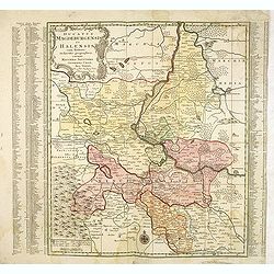
Ducatus Magdeburgensis Et Halensis cum finitimis Delineatio geographica. . .
Very decorative map centered on Magdeburg with Elbe river. With a key to the left and right of the map.
- $75 / ≈ €70
Place & Date: Augsburg, ca. 1740
L'Allemagne . . .
Map of Germany, from Atlas moderne portatif composé de vingt-huit cartes sur toutes les parties du globe terrestre .. A l'usage des Colléges, des Pensions & des Mai...
- $50 / ≈ €47
Place & Date: Paris, Prudhomme, Levrault, Debray, 1806
Ansicht des Heidelberger schlosses . . . Vue du château de Heidelberg . . .
Early lithographs after Louis Charles François de Graimberg-Belleau. Lithographed by Salathé.French artist. Son of Gilles-François Belleau Graimberg. Louis Charles Fra...
Place & Date: Graimberg, Heidelberg, ca. 1840
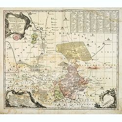
Nassovia Principatus Cum omnibus ei pertinentibus Comitatibus Dominiis ac Praefecturis ut et Confiniis intra Lahnun, Rhenum, et Moenum Flumina, ad situm verum exacte delineatus a Joh. Jac. Stetter. U.J.L. Idstenio-Nassovio . . .
Decorative map of the area between the rivers Rhine and Meuse, including Mainz, Koblenz, Frankfurt, Saarbrucken, etc.Includes an elaborate cartouche and coat of arms.The ...
- $150 / ≈ €140
Place & Date: Amsterdam, 1720
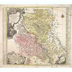
Saxoniae Superioris
Impressive title cartouche with miniature panoramic view of Leipzig, coat of arms, putti and Mercury.Johann Baptist Homann born in Kammlach (1663). He was engraver, map-s...
- $150 / ≈ €140
Place & Date: Augsburg, 1720
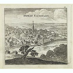
Donau Eschingen. / Der donaü stränd.
Two views pasted on recto and verso of a larger sheet of paper. On recto panoramic view of Donaueschingen a German town in the Black Forest.On verso a map of the Danube a...
- $75 / ≈ €70
Place & Date: Nuremberg, Jacob Sandrart, 1684
Delineatio geographica praefecturarum Wittebergensis, et Graefenhaynichen. . .
Showing Amt Wittenberge with the river Elbe. Wittenberge is a town of eighteen thousand people on the middle Elbe in the district of Prignitz, Brandenburg.
- $75 / ≈ €70
Place & Date: Augsburg, 1740
Buchaviae / Waldeccensis Comitatus.
Two maps on one sheet. The map on the left is based on Wolfgang Regerwyl's 1574 single fulda map. The map of Waldeck is based on Joist Moers map of 1572. Abraham Ortelius...
- $100 / ≈ €94
Place & Date: Antwerp, 1598
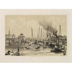
Hambourg.
Uncommon and decorative lithography of the harbor of Hamburg, published by Carl Johan Billmark and printed by Lemercier in Paris, 55 rue de Seine, the leading firm in Eur...
- $90 / ≈ €84
Place & Date: Paris, c.1859
Delineatio geographica praefecturarum Wittebergensis et Graefenhaynichen; in circulo electorali sitarum. . .
Very decorative map of Mansfeld Land, a region in the southwestern corner of the German state of Saxony-Anhalt. The region derives its name from the counts of Mansfeld, w...
- $75 / ≈ €70
Place & Date: Augsburg, ca. 1740
Delineatio Geographica Ditionis Martisburgensis hodie regiis et electoralibus auspiciis florentis edita. . .
Map shows the surrounding of the city of Halle. With a very large title cartouche occupying the lower left corner. Engraved by Tobias Conrad Lotter.
- $75 / ≈ €70
Place & Date: Augsburg, 1740
Haute Partie de la Basse Saxe..
Fine map of the northeastern part of Germany, including Hamburg and the rivers Wesel and Elbe. This edition carries the date 1679. Nicolas Sanson was to bring about th...
- $75 / ≈ €70
Place & Date: Paris, 1679

Vue du château de Heidelberg . . . Ansicht des Heidelberger schlosses . . .
Engraving after Louis Charles François de Graimberg-Belleau. Engraved by Charles Haldenwang.French artist. Son of Gilles-François Belleau Graimberg. Louis Charles Fran�...
Place & Date: Graimberg, Heidelberg, ca. 1840
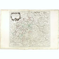
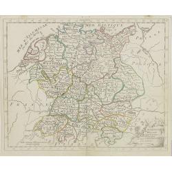
Carte de L'Empire D'Alemagne avec les Etats de Bohême..
Attractive map centered on the southwestern part of Germany, including Switzerland, Luxembourg and part of Austria.Decorative title cartouche with wine grapes, musical in...
- $75 / ≈ €70
Place & Date: Paris ca 1783