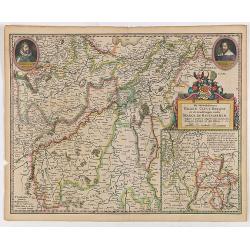
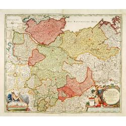
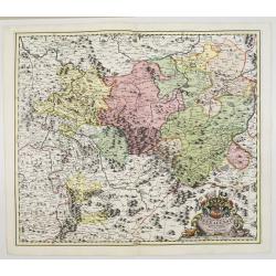
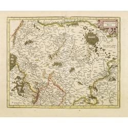
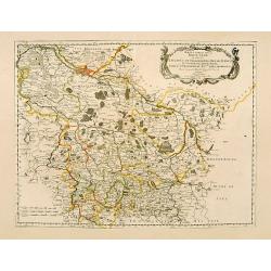
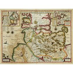
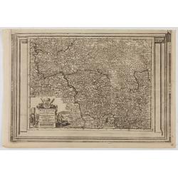
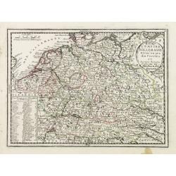
De Hertochdommen Gulick Cleve Berghe en de Graefschappen...
It is one of Blaeu's early maps: It was only published between 1630 and 1635 in three editions of the "Appendix" and one of the "Theatrum". In the lef...
Place & Date: Amsterdam, 1635

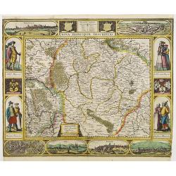
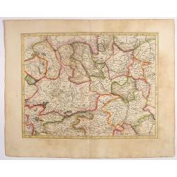
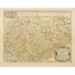
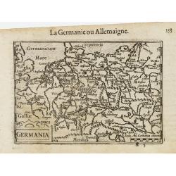
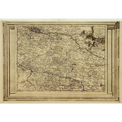
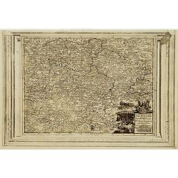
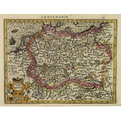
Germaniae Nova ac Accurata Descriptio.
This "carte à figures"- map covers the Low Countries, Germany, Poland, Switzerland and Austria. Overall a very good copy of this excellently engraved, uncommon...
Place & Date: Amsterdam, 1642

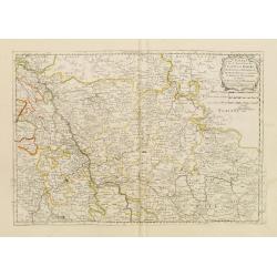
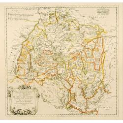
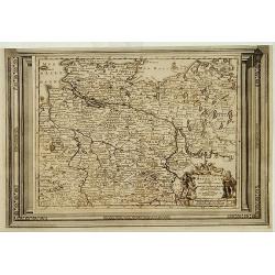
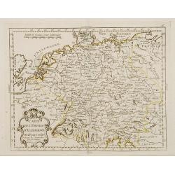
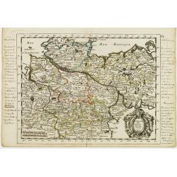
Palatinatus Rheni Nova et Accurata Descriptio.
Early state (1630) of Visscher's "carte à figures"- map of the German Rhine River Valley. Inset views of Frankfurt am Main, Mainz, Speyer, Worms and Heidelberg...
Place & Date: Amsterdam, 1630

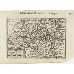
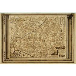
Coloniensis Archiepisscopatus.
Extremely rare first edition of this beautiful map of Cologne and Dusseldorff.Jodocus Hondius Jr. planned to produce a new modern atlas less dependent on the Mercator pla...
Place & Date: Amsterdam, 1629
Monasteriensis Episcopatus.
The extremely rare first edition of this beautiful map of Munster.Jodocus Hondius Jr. planned to produce a new modern atlas less dependent on the Mercator plates that his...
Place & Date: Amsterdam, 1629
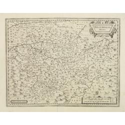
Westphalia Ducatus.
Extremely rare first edition of this beautiful map of Westphalia.Jodocus Hondius Jr. planned to produce a new modern atlas less dependent on the Mercator plates that his ...
Place & Date: Amsterdam, 1629
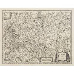
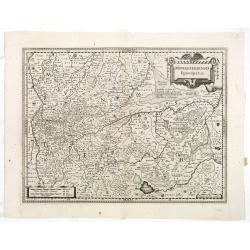
Sueviae Nova Tabula.
Extremely rare first edition of this beautiful map of Swaben, including Ulm, Augsburg, Stuttgart, Zurich, Lucerne and Lake Constance.Jodocus Hondius Jr. planned to produc...
Place & Date: Amsterdam, 1629
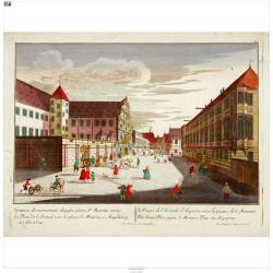
Der Zeug=Platz gegen S.Morizen Plaz zu Augspurg.
A well-known publisher of optical prints, established in Augsburg.In the eighteenth and nineteenth centuries there were many popular speciality establishments in Paris, A...
- $200 / ≈ €187
Place & Date: Augsburg, 1760
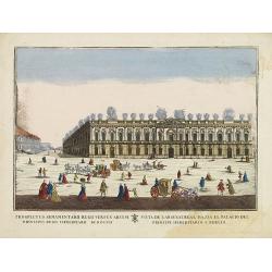
(Berlin) Prospectus Armamentarii regnii versus arcem principis regis haereditarii Berolini.
A square in Berlin. In the eighteenth and nineteenth centuries there were many popular speciality establishments in Paris, Augsburg and London which produced optical view...
- $300 / ≈ €281
Place & Date: Italy, 1770
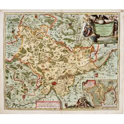
Nova Totius Westphaliae descriptio.
Map of the northern provinces of Germany, including the Wad islands. West to the top. Including Bremen, Hildesheim, Kassel, Düsseldorf, etc. Also including the Dutch pro...
Place & Date: Amsterdam, 1680

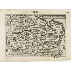
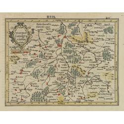
Hassia Landgraviatus.
Centered on the town of Kassel.
Place & Date: Amsterdam, 1650
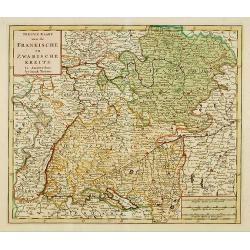
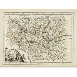
Nieuwe Kaart van de Frankische en Zwabische Kreits.
Deatailed map of the Southern part of Germany. Isaak Tirion was born in Utrecht ca. 1705. He came to Amsterdam ca. 1725. Tirion published a number of important books, m...
- $100 / ≈ €94
Place & Date: Amsterdam, 1745

Nieuwe Kaart van de Westfaalse Kreits..
Isaac Tirion was born in Utrecht ca. 1705. He came to Amsterdam ca. 1725. Tirion published a number of important books, many of which are still in demand for their intere...
Place & Date: Amsterdam, 1745
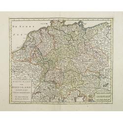
Nieuwe Kaart van Duitsland..
Detailed map of Germany, including The Netherlands, Belgium, Luxembourg, Switzerland and Austria. Isaac Tirion was born in Utrecht ca. 1705. He came to Amsterdam ca. 1725...
- $120 / ≈ €112
Place & Date: Amsterdam, 1747
Circulus Saxoniae inferioris.
Detailed map of Saxen, including Bremen, Berlin, Lübeck, etc. Johann Baptist Homann (1663-1724) was a German engraver and publisher, who established himself and his fami...
- $200 / ≈ €187
Place & Date: Nuremberg 1740
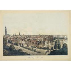
Hamburg im Jahre 1813
Decorative lithographed view of Hamburg. The print is issued in colors but finished by hand.
- $150 / ≈ €140
Place & Date: Germany,1820

Alssleben.
The engraver and publisher of prints, Mrs. Anna Beek of the Hague, enlarged the print and mounted it on larger paper: she colored it in pastel colors, adding extensive cl...
Place & Date: The Hague, ca. 1700
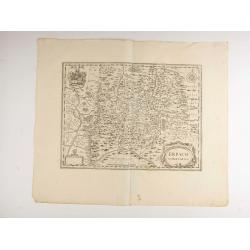
Erpach.
The town of Heidelberg is in most southern point on the map, including the rivers Rhine, Necker and Main.Rare issue published in Oxford. In 1680 the copper plates of Jans...
- $100 / ≈ €94
Place & Date: Oxford, 1680
Nova Franconiae Descriptio.
In 1626 Abraham Goos engraved a single-sheet "carte à figures"- map of Franconia with decorative borders for Joannes Janssonius. In the center part of the top ...
- $3000 / ≈ €2807
Place & Date: Amsterdam, 1626
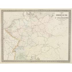
Carte des Chemins de Fer de l'Allemagne.
Fine map of Germany, The Netherlands and Eastern Europe, showing the early railway system of the area. From Atlas des Chemins de Fer published by Napoléon Chaix and pri...
Place & Date: Paris, 1863
Selling price: $2
Sold in 2011
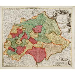
Nova Territorii Erfordien in suas praefecturas..
"Showing the area of Erfurt. In the lower part, there is a panoramic view of the town. Lower left and right splendid cartouches.The cartouches are painted in a stron...
- $300 / ≈ €281
Place & Date: Nurenberg, 1740
Nova et accurata Territorii Ulmensis cum dominio Wainensi..
"Showing the area of Ulm. In lower part inset map of property ""zu Wein"". Upper right splendid title cartouche.The map is painted in strong and ...
- $500 / ≈ €468
Place & Date: Nurenberg 1720
Principatus Isenacensis cum adjacentibus. . .
Detailed map centered on Gotha and Erfurt. Lower right splendid title cartouche.The map is painted in strong colors. Clearly from an show-piece atlas produced for a wealt...
- $300 / ≈ €281
Place & Date: Nurenberg, 1710
Saxoniae Superioris
Impressive title cartouche with miniature panoramic view of Leipzig, coat of arms, putti and Mercury.Johann Baptist Homann born in Kammlach (1663). He was engraver, map-s...
- $150 / ≈ €140
Place & Date: Augsburg, 1720

Landgraviatus Alsatiae tam superioris..
Alsace, in the far north-eastern corner of France, stands out from other French wine regions thanks to its strong Franco-Germanic influences. Alsace is the only French wi...
Place & Date: Nurenberg, 1710
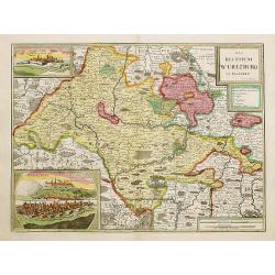
Das Bisthum Wurtzburg in Francken.
Rare map of Würzburg. With inset panoramic views of Würzburg and Köningshofen.The map is painted in strong colors. Clearly from an show-piece atlas produced for a weal...
- $1000 / ≈ €936
Place & Date: Nurenberg 1698
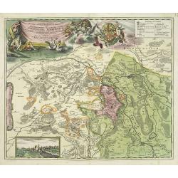
Geographica descriptio Montani cujusdam districtus in ..
Detailed map including the towns of Thurnau, Bayreuth, Culmbach, etc. With fine panoramic view of Thurnau. Upper left and right splendid title cartouches.The map is paint...
Place & Date: Nurenberg, 1710
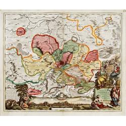
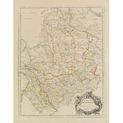
Palatinatus Rheni.
Map depicting part of Germany provinces.
Place & Date: Amsterdam, 1630
![Madeburga [ Maagdenburg Folio CLXXX ]](/uploads/cache/12338-250x250.jpg)
Madeburga [ Maagdenburg Folio CLXXX ]
Double-page panoramic view of Magdeburg. A imaginary view, however the earliest obtainable view of this period.Two page from the richest illustrated Incunable, the famous...
Place & Date: Nuremberg, 12 July 1493
Westfaliae.
A nice map showing the province of Westphalia.Mercator was born in Rupelmonde in Flanders and studied in Louvain under Gemma Frisius, Dutch writer, astronomer and mathema...
- $100 / ≈ €94
Place & Date: Amsterdam, 1630
Estats de la Succession de Cleves/ Iuliers..
Fine map of western Germany.This edition carries the date 1650 and the publishers address A PARIS chez l'Autheur aux Galleries du Louvre. Nicolas Sanson was to bring abou...
- $60 / ≈ €56
Place & Date: Paris 1650
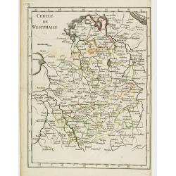
Cercle de Westphalie.
Fine map of Westphalia. The address is much re-worked, now with the address Chez L'Autheur aux Galleries du Louvre , dated 1690.This edition carries the date 1690 and the...
- $100 / ≈ €94
Place & Date: Paris 1690
Haute Partie de la Basse Saxe..
Fine map of the northeastern part of Germany, including Hamburg and the rivers Wesel and Elbe. This edition carries the date 1679. Nicolas Sanson was to bring about th...
- $75 / ≈ €70
Place & Date: Paris, 1679
Haute Saxe.. Duche de Saxe... / Marquisat de Misnie..
Fine map of Saxony.This edition carries the date 1655. Engraved by R.Cordier Abbauil.Nicolas Sanson was to bring about the rise of French cartography, although the fierce...
- $100 / ≈ €94
Place & Date: Paris, 1655
La Souabe.
Fine map of Swabia.This edition carries the date 1674 and the publishers address A PARIS chez l'Autheur aux Galleries du Louvre. Nicolas Sanson was to bring about the ris...
- $75 / ≈ €70
Place & Date: Paris, 1674
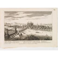
Nuremberg.
A very RARE panoramic view of the city of Nuremberg. The plate is numbered in red pencil in the upper right corner.Engraved by Pierre Aveline (Paris, c.1656 - 23 May 1722...
- $200 / ≈ €187
Place & Date: Paris, 1690-1720
Ausbourg Ville Impériale d'Allemagne dans la Suabe.
A very RARE panoramic of the city of Augsburg. The plate is numbered in red pencil in the upper right corner.Engraved by Pierre Aveline (Paris, c.1656 - 23 May 1722). He ...
- $250 / ≈ €234
Place & Date: Paris, 1690-1720
![Mayence Mentz en allemand .. [Metz]](/uploads/cache/13109-250x250.jpg)
Mayence Mentz en allemand .. [Metz]
A very RARE panoramic view of the city of Metz, including a numbered legend in the lower corners. The plate is numbered in red pencil in the upper right corner.Engraved b...
- $200 / ≈ €187
Place & Date: Paris 1690-1720
Treves en Allemend Trier.
A very RARE panoramic view of the city of Trier. The plate is numbered in red pencil in the upper right corner.Engraved by Pierre Aveline (Paris, c.1656 - 23 May 1722). H...
- $200 / ≈ €187
Place & Date: Paris, 1690-1720
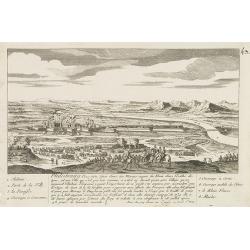
Philisbourg.
A very RARE panoramic view of the city of Philipsburg, including a numbered legend in both lower corners. The plate is numbered in black pencil in the upper right corner....
- $150 / ≈ €140
Place & Date: Paris c.1720
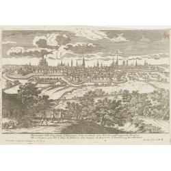
Ratisbonne.
A very RARE panoramic town view of the city of Ratisbonne, including a numbered legend in both lower corners. The plate is numbered in black pencil in the upper right cor...
- $200 / ≈ €187
Place & Date: Paris c.1720
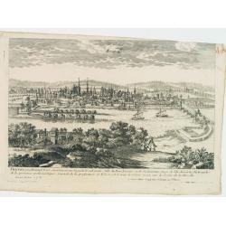
Breme.
A rare panoramic view of the city of Bremen, including a numbered legend in both lower corners.Published by the brothers Chéreau, active in Paris at rue st.Jacques au Gr...
- $200 / ≈ €187
Place & Date: Paris c.1720
Germania.
A miniature map of Germany. The title cartouche on the lower left corner. First published in 1598 in his Caert-Thresoor, the plates were executed by the most famous engra...
- $75 / ≈ €70
Place & Date: Amsterdam/Frankfurt, 1609
Coloniensis Diocesis.
A miniature map centered on Cologne. Title cartouche on the lower left corner.First published in 1598 in his Caert-Thresoor, the plates were executed by the most famous e...
- $80 / ≈ €75
Place & Date: Amsterdam / Frankfurt, 1609
Hassiae Descriptio / Hesse.
A miniature map centered on the province of Hessen. The title cartouche on the upper right corner.First published in 1598 in his Caert-Thresoor, the plates were executed ...
- $50 / ≈ €47
Place & Date: Amsterdam / Frankfurt, 1609
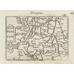
Noricum.
A miniature map showing a part of Bavaria, including the cities of Bamberg and Nuremberg. Title cartouche on the left side.First published in 1598 in his Caert-Thresoor, ...
- $50 / ≈ €47
Place & Date: Amsterdam / Frankfurt, 1609
![Sexta Etas Mundi. Ratisbonna. [Ratisbonne]](/uploads/cache/13549-250x250.jpg)
Sexta Etas Mundi. Ratisbonna. [Ratisbonne]
A very fine presentation of the city of Ratisbon, in Germany, centered on the cathedral (Dim. : 191 mm W : 525 mm).Overleaf a very nice view of Vienna, with two swans on ...
Place & Date: Nuremberg, 12 July 1493
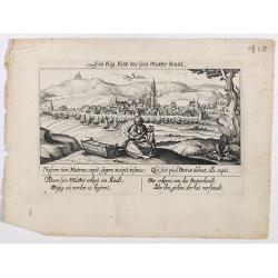
Sontra.
A panoramic view of the city Sontra in Hessen . With motto "ein klug Kind das sein Mutter kennt". On the foreground, a woman with two children and a crypt. With...
- $60 / ≈ €56
Place & Date: Frankfurt, 1623-1778
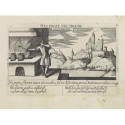
Croneburg.
A very nice picture representing the castle of Croneburg, of the German town of Kronenburg (now part of Dahlem). On the foreground, a man entertaining a fire is depicted....
- $75 / ≈ €70
Place & Date: Frankfurt, 1623-1678
![Merla in Ob. Hessen. [Merlau]](/uploads/cache/13826-250x250.jpg)
Merla in Ob. Hessen. [Merlau]
A panoramic view of the castle and town of Merlau in Hessen. In the foreground, two men fighting each other are depicted. With a verse in two languages underneath the pic...
- $40 / ≈ €37
Place & Date: Frankfurt, 1623-1678
Carte Generalle de la Germanie.
A rare map of the whole Germany. Very decorative title cartouche on the lower left-hand corner.With the mention A Paris chez Nicolas Berey Enlumineur de la Reine, Demeura...
- $1000 / ≈ €936
Place & Date: Paris, 1638
![Monacum. [Munich Folio CCXXVI ]](/uploads/cache/14365-250x250.jpg)
Monacum. [Munich Folio CCXXVI ]
A very fine representation of the city of Munich.Page from the richest illustrated Incunable, the famous: Nuremberg Chronicle, published the year that Columbus returned t...
- $2500 / ≈ €2339
Place & Date: Nuremberg, 12 July 1493
Ducatus Holsatiae nova tabula.
Finely engraved map centered on the area north of Hamburg and Lubeck with two insets. This is a second state of a map initially made by Jodocus Hondius.
- $250 / ≈ €234
Place & Date: Amsterdam, 1635
Le Duché de Lunebourg, suivant les nouvelles observations?
Uncommon edition of this map of a province of Germany. With decorative title cartouche upper right corner.This example is unusual in having the additional separately engr...
- $80 / ≈ €75
Place & Date: Amsterdam, 1728
Cercle de la Basse Saxe, suivant les nouvelles observations..
Uncommon edition of this map of a province of Germany, including Hamburg, Bremen, etc. With decorative title cartouche lower right corner.This example is unusual in havin...
- $90 / ≈ €84
Place & Date: Amsterdam 1728
La Souabe meridionale, suivant les nouvelles observations..
Uncommon edition of this map of Southern Germany. With decorative title cartouche lower right corner.This example is unusual in having the additional separately engraved ...
- $90 / ≈ €84
Place & Date: Amsterdam 1728
L'Archeveché de Mayence, suivant les nouvelles observations..
With decorative title cartouche lower left corner. Including river Rhine. This example is unusual in having the additional separately engraved decorative framework border...
- $100 / ≈ €94
Place & Date: Amsterdam, 1728
Landgraviat de Hesse, suivant les nouvelles observations..
With decorative title cartouche lower right corner.This example is unusual in having the additional separately engraved decorative framework border around the map, the re...
- $90 / ≈ €84
Place & Date: Amsterdam 1728
Carte de l'Empire d'Allemagne Divisé par Cercles..
Rare map of Germany and the Low Countries prepared by J.B.Nolin and published by Monhare for his Atlas Général a l'usage des colleges et maisons d'education.Louis Josep...
- $100 / ≈ €94
Place & Date: Paris, 1783
L' Allemagne par Postes.
Fine map of Germany. George Louis Le Rouge was active from 1740 to 1780 as a publisher and was appointed engineer for the King of France. From his "Atlas Nouveau Por...
- $60 / ≈ €56
Place & Date: Paris 1756
Le Marquisat et Electorat de Branderbourg.
Fine map of Brandenburg, with decorative title cartouche. George Louis Le Rouge was active from 1740- till 1780 as a publisher, and was appointed engineer for the King of...
- $30 / ≈ €28
Place & Date: Paris 1756
Cercle de Basse Saxe.
Fine map of Lower Saxony, with decorative title cartouche. With manuscript notes in left and right margins giving some historical information about the region. George Lou...
- $50 / ≈ €47
Place & Date: Paris, 1756
Cercle de Westphalie.
Fine map of North Rhine-Westphalia. George Louis Le Rouge was active from 1740 till 1780 as a publisher, and was appointed engineer for the King of France. From his Atlas...
- $30 / ≈ €28
Place & Date: Paris 1756
![Partie Septentrionale de la Souabe [and] Partie Meridionale de la Souabe. (2 maps)](/uploads/cache/21468-250x250.jpg)
Partie Septentrionale de la Souabe [and] Partie Meridionale de la Souabe. (2 maps)
Pair of maps forms a large, detailed view of Swabia, one of the ten circles of the Holy Roman Empire and containing some of the historically most interesting and cultural...
- $250 / ≈ €234
Place & Date: Amsterdam c. 1745
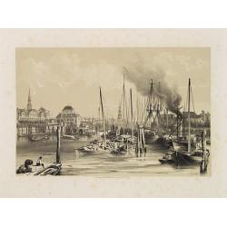
Hambourg.
Uncommon and decorative lithography of the harbor of Hamburg, published by Carl Johan Billmark and printed by Lemercier in Paris, 55 rue de Seine, the leading firm in Eur...
- $90 / ≈ €84
Place & Date: Paris, c.1859
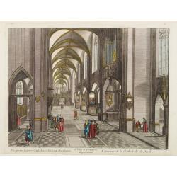
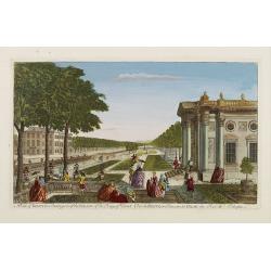
13e. Vüe d'Optique Representant L'Interieur de la Cathedralle de Dorth.
Optical view representing the interior of a Cathedral in Dörth, near Wiesbaden. Published by Daumont, a well-known publisher of optical prints, established in Paris.In t...
- $200 / ≈ €187
Place & Date: Paris, 1760
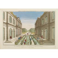
Vue perspective de l'Entrée du Parc du Prince de Manheim en Allemagne.
Perspective view of the Royal Park in Manheim by Basset, a well-known publisher of optical prints, established in rue St.Jacques in Paris. With brief key list.In the eigh...
- $200 / ≈ €187
Place & Date: Paris, 1760
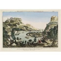
Vue perspective de la Ville et Forteresse Electorale de Koningstein, et de la Montagne de Lilienstein avec ses environs du côté du Couchant, dépendant des Etats de Saxe, appartenant à Sa Majesté le Roy de Pologne.
Perspective view of Königstein fortress, situated near to Dresden in Saxony. To the left the Fortress and in the foreground the river Elbe. The castle was inhabited by A...
Place & Date: Paris, 1760
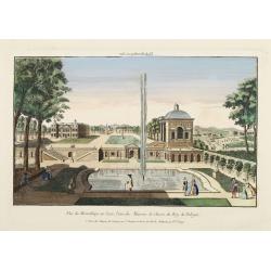
Vüe de Morestburg en Saxe, l'une des Maisons de Chasse du Roy de Pologne. (Castle Moritzburg)
So-called optical print illustrating a perspective view of the Castle Moritzburg, a Baroque Germanic castle in the small town of Moritzburg in the German state of Saxony....
- $250 / ≈ €234
Place & Date: Paris, 1760
A view of BILNITZ in Saxony one of the palaces of the King of Poland. / Vüe de Bilnitz, en Saxe, un des Palais du Roi de Pologne.
So-called optical print illustrating a perspective view of Pillnitz Castle, a restored Baroque castle at the eastern end of the city of Dresden. The castle was once the s...
- $300 / ≈ €281
Place & Date: Paris, 1760
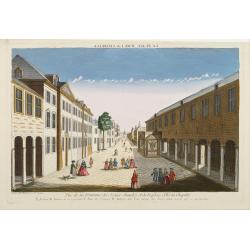
Vue de la Fontaine des Eaux chaudes et de la place d'Aix la Chapelle.
So-called optical print illustrating a perspective view of Aachen, in Nordrhein Westphalia, and namely the Elisa Fountain which contains two fountains with thermal water....
- $250 / ≈ €234
Place & Date: Paris, 1760

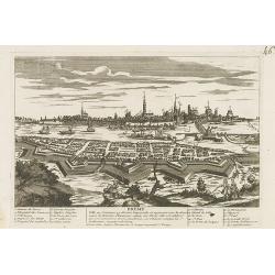
(Lübeck) Lvbeca vrbs. imperialis libera. civitatvm. Wandalicarvm. . . .
Impressive more than 3 meters wide panoramic town view after a woodblock engraving from Elias Diebel, initially made in 1552. Of this original woodblock, Bachmann mention...
- $4500 / ≈ €4211
Place & Date: Germany, c. 1855
L'Empire D'Allemagne Divisé en ses dix Cercles et Autres Estats..
Map centered on Germany, including Switzerland, Austria, part of France, Northern Italy and Eastern Europe. With title cartouche and a panel in the lower left corner list...
- $60 / ≈ €56
Place & Date: Paris 1719

Franciae orientalis../ Monasteriensis et osnaburgensis..
From 'Theatrum Orbis Terrarum [Atlas of the Whole World]' published in Antwerp. French text on verso.The map of Frankenland is prepared by Sebastian Rotenhan (1478-1532) ...
Place & Date: Antwerp, c.1574
La Germanie.
Small map of Germany, including Austria and part of Poland. Strap work title cartouche in the lower left.From the first French-text edition of Jodocus Hondius' Atlas Mino...
- $75 / ≈ €70
Place & Date: Amsterdam, 1608
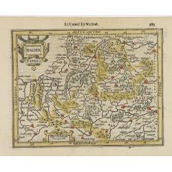
Waldek Comit.
Early map of the region surrounding Waldeck, northern Hessen. From the first French-text edition of Jodocus Hondius' Atlas Minor.Shortly after the publication of the big ...
- $45 / ≈ €42
Place & Date: Amsterdam, 1608
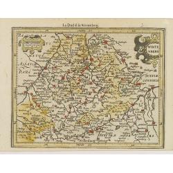
Wirtenberg.
Detailed map centered on Baden-Württemberg. With major cities of the area named.From the first French-text edition of Jodocus Hondius' Atlas Minor. Shortly after the p...
- $40 / ≈ €37
Place & Date: Amsterdam, 1608
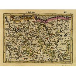
Saxonia Inferior et Mekleburg.
Detailed map showing part of northern Germany. With major cities of the area named.From the first French-text edition of Jodocus Hondius' Atlas Minor.Shortly after the pu...
- $80 / ≈ €75
Place & Date: Amsterdam, 1608
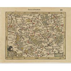
Brauswik et Meydburg com confinijs.
Detailed map showing the region around Brunswick and Magdeburg. With major cities of the area named.From the first French-text edition of Jodocus Hondius' Atlas Minor.Sho...
- $50 / ≈ €47
Place & Date: Amsterdam, 1608
Hassia Landgraviatus.
Detailed map showing the region around Kassel. With major cities of the area named.From the first French-text edition of Jodocus Hondius' Atlas Minor.Shortly after the pu...
- $50 / ≈ €47
Place & Date: Amsterdam, 1608