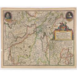
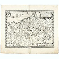
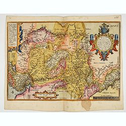
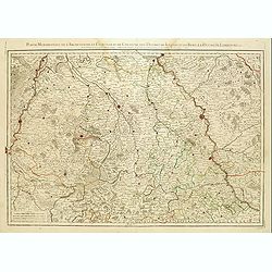
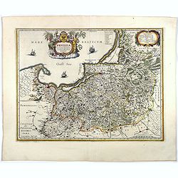
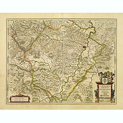
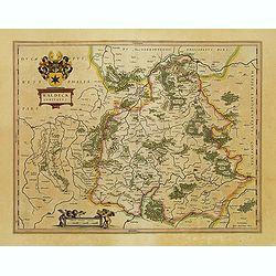
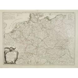
De Hertochdommen Gulick Cleve Berghe en de Graefschappen...
It is one of Blaeu's early maps: It was only published between 1630 and 1635 in three editions of the "Appendix" and one of the "Theatrum". In the lef...
Place & Date: Amsterdam, 1635
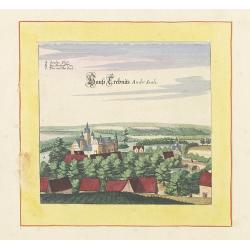
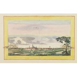
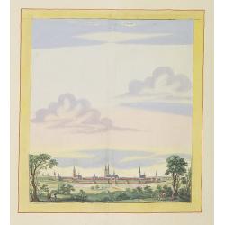
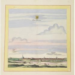
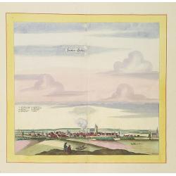
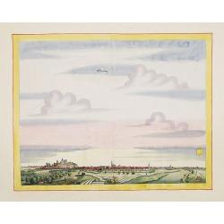
Haus trebnits an der saale.
Very decorative and rare panoramic of Trebnitz a.d Saale , Bez. Halle.The engraver and publisher of prints, Mrs. Anna Beek of the Hague, enlarged the print and mounted i...
Place & Date: The Hague, ca. 1642
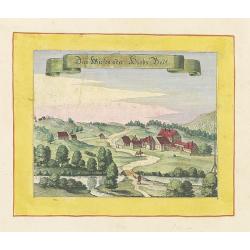
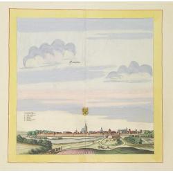
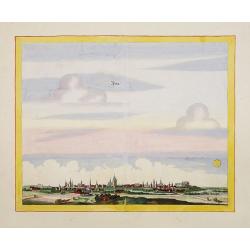
Das Wiesen oder Hiobs Badt.
Very decorative and rare panoramic town view of Wiensenbad near Annaberg im Erzgebirge.The engraver and publisher of prints, Mrs. Anna Beek of the Hague, enlarged the pri...
Place & Date: The Hague, ca. 1642
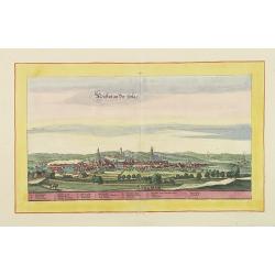
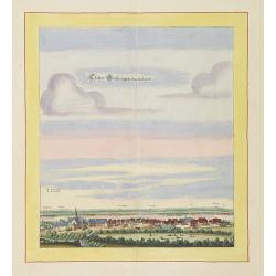
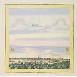
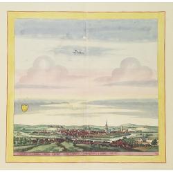
Weissensee.
Very decorative and rare panoramic town view of Weissensee in Thürigen, Bez. Erfurt.The engraver and publisher of prints, Mrs. Anna Beek of the Hague, enlarged the print...
Place & Date: The Hague, ca. 1642
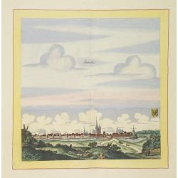
Hertzberg.
Very decorative and rare panoramic town view of Herzberg a.d. Schwarzen Elster, Bez. Cootbus.The engraver and publisher of prints, Mrs. Anna Beek of the Hague, enlarged t...
Place & Date: The Hague, ca. 1642
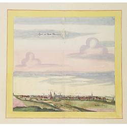
Newstatt an der Orla.
Very decorative and rare panoramic of Neustadt a.d. Donau, Kr. Kelheim, Ndb.The engraver and publisher of prints, Mrs. Anna Beek of the Hague, enlarged the print and mou...
Place & Date: The Hague, ca. 1642

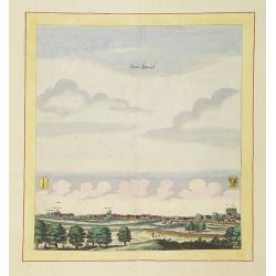
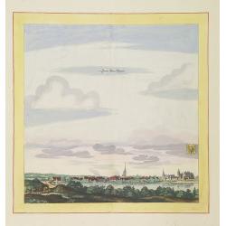
Greüssen.
Very decorative and rare panoramic town view of Greussen (Thür.),Bez. Erfurt .The engraver and publisher of prints, Mrs. Anna Beek of the Hague, enlarged the print and m...
Place & Date: The Hague, ca. 1642
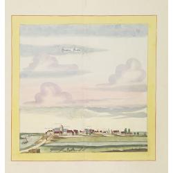
Schweet.
Very decorative and rare panoramic town view of Schwedt a.d Oder, Bez. Frankfurt a.d. Oder.The engraver and publisher of prints, Mrs. Anna Beek of the Hague, enlarged the...
Place & Date: The Hague, ca. 1642
Statt und Ambtt Wantzleben.
Very decorative and rare panoramic town view of Wanzleben, Bez. Magdeburg.The engraver and publisher of prints, Mrs. Anna Beek of the Hague, enlarged the print and mounte...
Place & Date: The Hague, ca. 1642
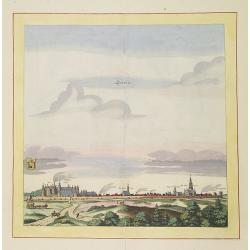
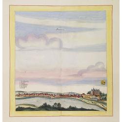
Stendalia Stendel
Very decorative and rare panoramic town view of Stendal, Bez. Magdeburg.The engraver and publisher of prints, Mrs. Anna Beek of the Hague, enlarged the print and mounted ...
Place & Date: The Hague, ca. 1700
Gloster Brüningen bei Halberstatt.
Very decorative and rare panoramic town view of Halberstatt.The engraver and publisher of prints, Mrs. Anna Beek of the Hague, enlarged the print and mounted it on larger...
Place & Date: The Hague, ca. 1700
Stättl Zedenick.
Very decorative and rare panoramic town view of Zedenick a.d. Havel, Bez. potsdam.The engraver and publisher of prints, Mrs. Anna Beek of the Hague, enlarged the print an...
Place & Date: The Hague, ca. 1700
Newenwedel.
Very decorative and rare panoramic town view of Newenwedel i.d. Neumark .The engraver and publisher of prints, Mrs. Anna Beek of the Hague, enlarged the print and mounted...
Place & Date: The Hague, ca. 1700
Statt Garleben.
Very decorative and rare panoramic town view of Gardelegen in Altmark.The engraver and publisher of prints, Mrs. Anna Beek of the Hague, enlarged the print and mounted it...
Place & Date: The Hague, ca. 1700
Templin
Very decorative and rare panoramic town view of Templin in Uckermark.The engraver and publisher of prints, Mrs. Anna Beek of the Hague, enlarged the print and mounted it ...
Place & Date: The Hague, ca. 1700
Calvorde.
Very decorative and rare panoramic of Calvörde, Bez. Magdeburg.The engraver and publisher of prints, Mrs. Anna Beek of the Hague, enlarged the print and mounted it on l...
Place & Date: The Hague, ca. 1700
Seehaüsen.
Very decorative and rare panoramic of Seehausen, Altmark, Bez. Magdeburg .The engraver and publisher of prints, Mrs. Anna Beek of the Hague, enlarged the print and mount...
Place & Date: The Hague, ca. 1700
Stättlein Saltza.
Very decorative and rare panoramic town view of Salzelmen Bad Salzemen, Bez. Magdeburg. The engraver and publisher of prints, Mrs. Anna Beek of the Hague, enlarged the pr...
Place & Date: The Hague, ca. 1700
Döblen.
Very decorative and rare panoramic of Döblen in Sachsen.The engraver and publisher of prints, Mrs. Anna Beek of the Hague, enlarged the print and mounted it on larger p...
Place & Date: The Hague, ca. 1700
Stättlein Frohsa.
Very decorative and rare panoramic town view of Frohse a.d. Elbe, Bez. Magdeburg.The engraver and publisher of prints, Mrs. Anna Beek of the Hague, enlarged the print and...
Place & Date: The Hague, ca. 1700
Statt Alten Rüppin.
Very decorative and rare panoramic town-view of Statt Alten Rüppin.The engraver and publisher of prints, Mrs. Anna Beek of the Hague, enlarged the print and mounted it o...
Place & Date: The Hague, ca. 1700
Eilenburg.
Very decorative and rare panoramic view of Eilenburg a.d. Mulde.The engraver and publisher of prints, Mrs. Anna Beek of the Hague, enlarged the print and mounted it on la...
Place & Date: The Hague, ca. 1700
Zerbst.
Very decorative and rare panoramic town view of Zerbst in Bez, Magdeburg.The engraver and publisher of prints, Mrs. Anna Beek of the Hague, enlarged the print and mounted...
Place & Date: The Hague, ca. 1700
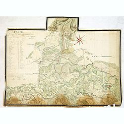
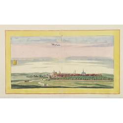
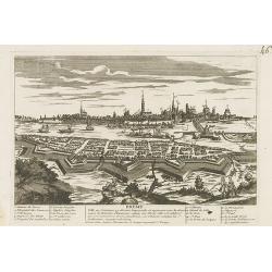
Carte du cours du Rhin dpuis le fort de Schengen jusqu'à Lauterbourg. . .
Beautiful manuscript map of the region around Rastatt and the siege of 1714 signed with the French emperor Charles VI of Habsburg. In top with a small extension of the ma...
Place & Date: Germany, France, c. 1714
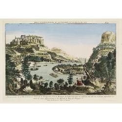
Vue perspective de la Ville et Forteresse Electorale de Koningstein, et de la Montagne de Lilienstein avec ses environs du côté du Couchant, dépendant des Etats de Saxe, appartenant à Sa Majesté le Roy de Pologne.
Perspective view of Königstein fortress, situated near to Dresden in Saxony. To the left the Fortress and in the foreground the river Elbe. The castle was inhabited by A...
Place & Date: Paris, 1760
Meklenburg Ducatus.
Very detailed map of the northern part of Germany decorated with a coat of arms, a windrose and two saling ships.From the rare atlas Appendix, published in a very small n...
Place & Date: Amsterdam, 1629-1630
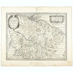
Ducatus Luneburgensis
Very detailed map centered on Albis river and the cities of Hamburg and Lunburg to the north. Also showing Bremen.
Place & Date: Amsterdam, 1629-1630
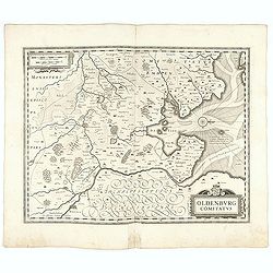
Oldenburg Comitatus
A map of the northern part of Germany centered on Oldenburg. Also showing Bremen. North to the right. The decoration consists with a windrose and a title cartouche surmou...
Place & Date: Amsterdam, 1629-1630
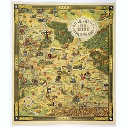
US ZONE. Bavaria, Hesse, Wurtemberg, Baden.
An unusual decorative pictorial map, from the years immediately following World War II, depicting the American Zone of Occupation in southern Germany. It portrays rural ...
Place & Date: Munich, 1940
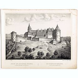
Ansicht der Heidelberger Schlosses. . .
Early lithograph published by Louis Charles François de Graimberg-Belleau. Lithographed by C.F Müller.French artist. Son of Gilles-François Belleau Graimberg. Louis Ch...
Place & Date: Graimberg, Heidelberg, ca. 1840
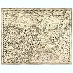
Westphaliae Totius, Finitimarumque Regionum Accurata Descriptio.
A very beautiful hand colored copper engraved map of North Rhein-Westphalia by A. Ortelius. This is a general map of Westphalia and the surrounding regions in northwest G...
Place & Date: Antwerp, ca 1584
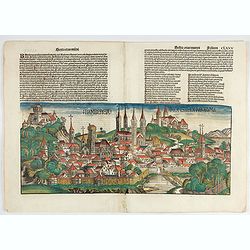
Bamberga. Folium CLXXV
Double page panoramic view of Bamberg. One of the earliest obtainable view of this period.Two page from the richest illustrated Incunable, the famous: Nuremberg Chronicl...
Place & Date: Nuremberg, 12 July 1493
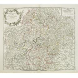
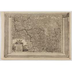
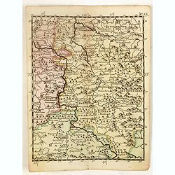
Cercle de Franconie . . .
Finely and crisply engraved map of part of Germany. Map by Giles Didier Robert De Vaugondy with erased title cartouche. Ornamental title cartouche in the upper part of ma...
- $80 / ≈ €75
Place & Date: Paris, 1752
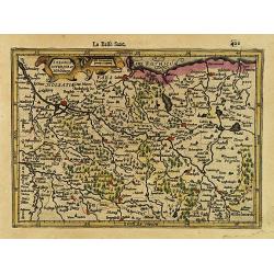
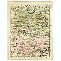
Partie Méridionale de l'Archevesché et Eslectorat de Cologne. . .
Fine map of the Westphalia, the area in-between the Rivers Maas and Rhine.
- $50 / ≈ €47
Place & Date: Paris, 1707
![[Breisach] Profil de la ville de Brisac scituée sur le Rhin dans le Brisgau prise par l'armée du Roy commandée par Monseign.r le duc de Bourgogne le 6.e septembre 1703.](/uploads/cache/43496-250x250.jpg)
[Breisach] Profil de la ville de Brisac scituée sur le Rhin dans le Brisgau prise par l'armée du Roy commandée par Monseign.r le duc de Bourgogne le 6.e septembre 1703.
Scene of the siege of Breisach in 1703 by Marshal Tallard during the Spanish Succession War.
- $200 / ≈ €187
Place & Date: Paris, 1703
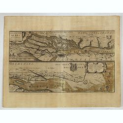
Celeberrimi Fluvis Albis nova delineatio. . .
A decorative map from a 1640's Latin text edition of Blaeu's "Theatrum Orbis Terrarum, Sive Atlas Novis." The River Elbe is depicted in two sections from the mo...
- $80 / ≈ €75
Place & Date: Amsterdam, 1644
Ducatus Westphaliae Cum annexis.
Extremely rare map of Westphalia sold separately and later included in the first Regional Atlas "Prodomus Geographicus, hoc est archiepiscopatus Coloniensis annexaru...
- $1000 / ≈ €936
Place & Date: Cologne, F. Hogenberg, ca. 1620
Saxonia Inferior et Mekleburg.
Detailed map showing part of northern Germany. With major cities of the area named.From the first French-text edition of Jodocus Hondius' Atlas Minor.Shortly after the pu...
- $80 / ≈ €75
Place & Date: Amsterdam, 1608
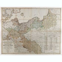
General Charte der Preussischen Monarchie in zwey Blattern. . .
Uncommon and detailed map of Kingdom of Prussia with present day Poland and Germany. Uncommon map engraved by Ludwig Hess and published in Weimar by Fr. Wilhelm Streit.
- $1000 / ≈ €936
Place & Date: Weimar, 1812

US ZONE. Bavaria, Hesse, Wurtemberg, Baden.
An unusual decorative pictorial map, from the years immediately following World War II, depicting the American Zone of Occupation in southern Germany. It portrays rural ...
- $450 / ≈ €421
Place & Date: Munich, 1940
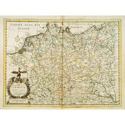
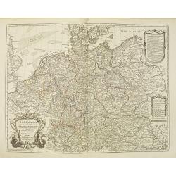
Carte Generalle de la Germanie.
A rare map of the whole Germany. Very decorative title cartouche on the lower left-hand corner.With the mention A Paris chez Nicolas Berey Enlumineur de la Reine, Demeura...
- $1000 / ≈ €936
Place & Date: Paris, 1638
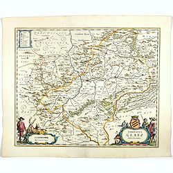
Comitatus Stolbergici ad Hercyniam. . .
The County of Stolberg (Grafschaft Stolberg) was a county of the Holy Roman Empire located in the Harz mountain range in present-day Saxony-Anhalt, Germany. It was ruled ...
- $100 / ≈ €94
Place & Date: Nuremberg, ca 1740
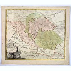
Comitatus Glatz.
Nice map by Willem Blaeu of the Silesia region with Glatz (Klodzko) at center. The forested region was renowned for its wild game and the map includes tiny illustrations ...
- $450 / ≈ €421
Place & Date: Amsterdam, 1644
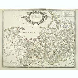
Prussia accurate descriptia a Gasparo Henneberg Erlichensi.
Prussia and the Baltic Region, with two large decorative cartouches, coat of arms, and three sailing ships. As indicated in the title cartouche, the map was prepared by t...
Place & Date: Amsterdam, 1644
Selling price: $500
Sold in 2017
La Germania divisa ne' suoi differenti stati
Rare map of Germany, from "Atlante Novissimo ad uso Dei Giovani Studiosi Contenuto In Carte XXVII.", published by Giovanni Zempel in Rome, ca. 1780.The map is b...
- $25 / ≈ €23
Place & Date: Rome, 1780
L'Archeveché de Mayence, suivant les nouvelles observations..
With decorative title cartouche lower left corner. Including river Rhine. This example is unusual in having the additional separately engraved decorative framework border...
- $100 / ≈ €94
Place & Date: Amsterdam, 1728
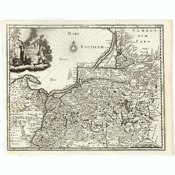
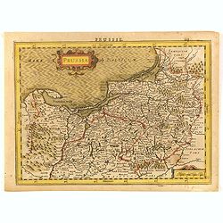
Prussiae nova tabula.
Rare map of Prussia with nowadays Poland. The map features a bold title cartouche, a ship, compass rose, and a sea monster in the Baltic Sea. The map was prepared by the ...
- $550 / ≈ €515
Place & Date: Amsterdam, 1647
Mansfeldiae Comitatus.
A very fine map centered on the city of Mansfelt . A very nice title cartouche in the upper right corner. Signed by the engraver Franz Hogenberg lower left. Abraham Ortel...
- $75 / ≈ €70
Place & Date: Antwerp, 1598
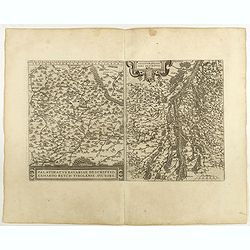
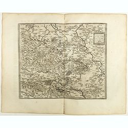
Palatinatvs Bavariae . . . / Argentoratensis agri . . .
From 'Theatrum Orbis Terrarum [Atlas of the Whole World]. The left-hand map of Bavaria is after Erhart Reych's 4-sheet map of 1540. Including the towns of Regensburg, Nü...
- $100 / ≈ €94
Place & Date: Antwerp, 1598
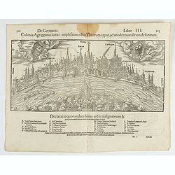
Colonia Agrippina civitas…
A wood block printed early panoramic view of Cologne (Germany). A lettered key A-Z beneath the view. The 1552 Latin text edition of Münster's Cosmographia is a short and...
- $70 / ≈ €66
Place & Date: Basel, 1552
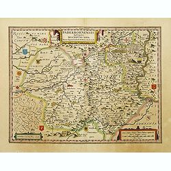
Paderbornensis Episscopatus Descriptio Nova.
Detailed map by Willem Blaeu., centered on Paderborn. Embellished with several coats of arms. Prepared by Joannes Michael Gigas (1580-1650+), a doctor, mathematician and ...
- $175 / ≈ €164
Place & Date: Amsterdam, 1640
Territorium Abbatiae Herefeldensis - 't Stift Hirszfeldt.
Detailed map centered on Hirschfelt. Title cartouche embellished with two cherubs.
- $250 / ≈ €234
Place & Date: Amsterdam, 1647
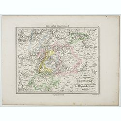
Le Vie Ferrate e le Strade Postali della Germania centrale e meridionale . . .
Uncommon map of Germany and part of France and Switzerland prepared by Francesco Costantino Marmocchi. Above the map "Geografia Commerciale". From "Il Glob...
- $25 / ≈ €23
Place & Date: Genova, Paolo Rivara fu Giacomo, 1858
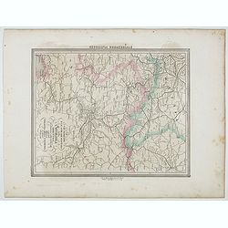
Le Vie Ferrate e le Strade Postali della Germania orientale . . .
Uncommon map of Germany and part of Poland, Hungary and Italy prepared by Francesco Costantino Marmocchi. Above the map "Geografia Commerciale". From "Il G...
- $25 / ≈ €23
Place & Date: Genova, Paolo Rivara fu Giacomo, 1858
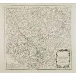
Carte des Cercle du Haut et du Bas Rhin.. avec leurs enclaves.
Finely and crisply engraved map of Germany showing the river Rhine, including Duisburg, Spire, Mannheim, etc.Venetian edition of Giles Didier Robert De Vaugondy's map fro...
- $100 / ≈ €94
Place & Date: Venice, 1776 - 1784
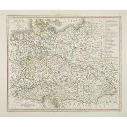
L'Allemagne dressée sur les observations. . .
Map of Germany, Low Countries, Poland, Switzerland, Northern Italy. Prepared by G.De L'Isle after observations by Kepler and Tycho Brahe.Engraved by Jean Batiste Liébaux...
- $300 / ≈ €281
Place & Date: Paris, 1788
Allemagne . . .
Detailed map of Germany and Austria, prepared by A. H. Basset, rue Saint-Jacques, no. 64, Paris and published in Atlas classique et Universel de Géographie . . . .The en...
- $80 / ≈ €75
Place & Date: Paris, A.H. Basset, 1828
L'Alemagna . . .
A rare double-page map of Germany and Poland. Prepared by Las Casas and engraved by G.V.Pasquali for l'Atlante Storico, Letterario, Biografico, Archeologico. . . with at...
- $50 / ≈ €47
Place & Date: Venice, 1840
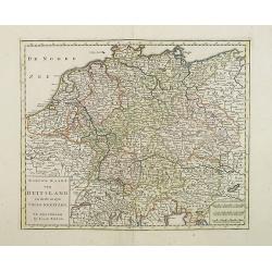
Nieuwe Kaart van Duitsland..
Detailed map of Germany, including The Netherlands, Belgium, Luxembourg, Switzerland and Austria. Isaac Tirion was born in Utrecht ca. 1705. He came to Amsterdam ca. 1725...
- $120 / ≈ €112
Place & Date: Amsterdam, 1747
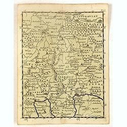
La Prusse divisée en Prusse royale, et Prusse Ducale. . .
Finely and crisply engraved map of Prussia including The Bay of Danzig. Ornamental title cartouche in the upper part of the map from his "Atlas Universel".Gille...
- $300 / ≈ €281
Place & Date: Paris, 1750
La Prussia Divisa in Reale Che Appartiene al Ré Di Polonia et in Ducale Che Spetta all'Elettore Di Brandeburgo. Da Giacomo Cantelli Da ...
In the upper left-hand corner a large title cartouche with a dedication to Cardinal Denhoff. The map is dated 1689.The cartographer was Giacomo Cantelli (1643-1695) who w...
- $1000 / ≈ €936
Place & Date: Rome, 1689
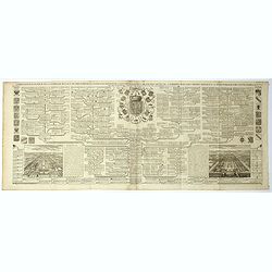
Carte genealogique de la famille Royale de Brunswick . .
A very detailed composite sheet with a genealogical table of the German royal families of Brunswick, Luneburg and Hanover, with descriptive French textZacharie Chatelain ...
- $50 / ≈ €47
Place & Date: Amsterdam, ca. 1720
(Schweinfurt, Reineck, Hirschfeld, etc.)
Rare miniature map including the towns of Schweinfurt, Reineck, Hirschfeld, etc. From "Le theatre De Bellone, Contenant 48. nouvelles Cartes Geographiques, Des Païs...
- $60 / ≈ €56
Place & Date: Amsterdam, 1710
(Hildesheim, Munden, Steinbrugge, Grubenhagen, etc.)
Rare miniature map including the towns of Hildesheim, Munden, Steinbrugge, Grubenhagen, etc. From "Le theatre De Bellone, Contenant 48. nouvelles Cartes Geographique...
- $60 / ≈ €56
Place & Date: Amsterdam, 1710
(Ochfenfurt, Hall, Bavaria, etc.)
Rare miniature map of Bavaria including the towns of Ochfenfurt, Hall, etc. From "Le theatre De Bellone, Contenant 48. nouvelles Cartes Geographiques, Des Païs-Bas ...
- $60 / ≈ €56
Place & Date: Amsterdam, 1710
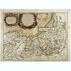
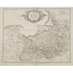
Prussia.
An attractive, detailed and early map of present-day Poland and Lithuania. From the Cloppenburg edition slightly larger format and more scarce edition of the Mercator/Hon...
- $450 / ≈ €421
Place & Date: Amsterdam, 1630

Magnae Prussiae Ducatus Tabula denuo correcta et in lucem edita per Nicolaum Visscher.
Striking old color example of Visscher's map of Prussia and part of the Baltic region. Includes a gorgeous cartouche and banner key held aloft by 2 cherubs, plus 4 sailin...
- $1500 / ≈ €1404
Place & Date: Amsterdam, 1690
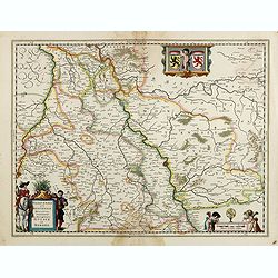
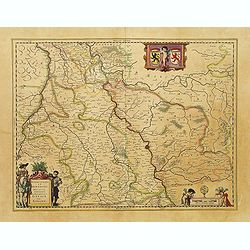
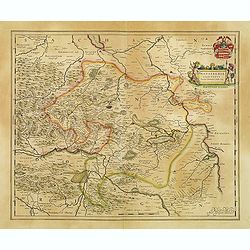
Juliacensis et Montensis Ducatus/ De Hertoghdomen Gulick. . .
Map of the area to both sides of the Rhine between Bonn and Wesel, centered on Düsseldorf and reaching to Maastricht in the west and Altena/Westfalen in the east.Decorat...
- $100 / ≈ €94
Place & Date: Amsterdam, 1638
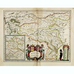
Comitatus Marchia et Ravensberg.
With an inset of Ravensberg comitatus. Decorative title cartouche with coats of arms. Scale cartouche with a surveyor.As Willem Blaeu died in 1638 most of his maps are ac...
- $80 / ≈ €75
Place & Date: Amsterdam, 1638
Carte générale d'Alemagne divisée par les cercles ou provinces d'icelle.
Rare and detailed map of Germany, Poland and Austria, engraved by H. le Roy in 1643 or 1666 for Jacques L'Agniet. Published by François Jollain (ca. 1641 – 18 April 17...
- $450 / ≈ €421
Place & Date: Paris, 1689
Carte de l'Empire d' Allemagne . . .
Scarce map of Germany prepared by de la Fosse and published by L.J. Mondhare for his Atlas Général a l'usage des colleges et maisons d'education.. Louis Joseph Mondhare...
- $50 / ≈ €47
Place & Date: Paris, 1783
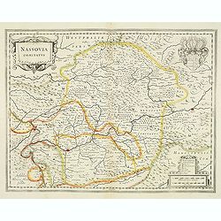
Nassovia comitatus.
Elegantly engraved map of the region including Koblenz Sigen and Dillenburg. The mountainous topography is graphically depicted and there is a coats of arms in the corner...
- $75 / ≈ €70
Place & Date: Amsterdam, after 1633
Breme.
A rare panoramic view of the city of Bremen, including a numbered legend in both lower corners.Published by the brothers Chéreau, active in Paris at rue st.Jacques au Gr...
- $200 / ≈ €187
Place & Date: Paris c.1720
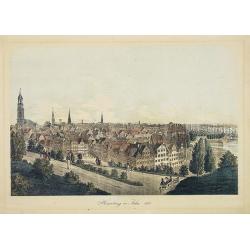
Hamburg im Jahre 1813
Decorative lithographed view of Hamburg. The print is issued in colors but finished by hand.
- $150 / ≈ €140
Place & Date: Germany,1820
Waldeck Comitatus.
Map centered on Waldeck, Korbach, etc.
- $100 / ≈ €94
Place & Date: Amsterdam, 1640
Juliacensis et Montensis Ducatus / De Hertoghdomen Gulick en Berghe.
Detailed map centered on Cologne. Embellished with scale cartouche with cherubs, a cartouche with a putti inside holding two coats of arms. Lower left corner, the title c...
- $150 / ≈ €140
Place & Date: Amsterdam, 1645
L'Empire d'Allemagne..
Detailed map encompassing Germany, the Netherlands, Belgium, Austria, and part of Poland.Venetian edition of the map by Bellin, to whom Santini gives credit in the cartou...
- $100 / ≈ €94
Place & Date: Venice, 1776 - 1784
La Prusse divisée en Prusse Royale et Prusse Ducale. . .
Finely and crisply engraved map of Prussia including The Bay of Danzig. Folio map by Giles Didier Robert De Vaugondy.Ornamental title cartouche in the upper part of the m...
- $350 / ≈ €328
Place & Date: Paris, 1751
Mansfeldia Comitatus..
Centered on Mansfeld and prepared by Tilemano Stella (1527-1589) a German cartographer who made maps of Germany and the Holy Land.
- $100 / ≈ €94
Place & Date: Amsterdam, 1640
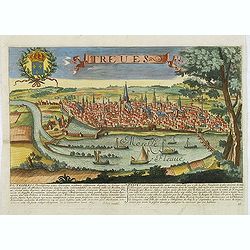
Treves. (Trier)
Rare and decorative view of Tier with the river Meuse in the foreground. Underneath a historical description of the town in Latin and French. The description mentions abo...
- $1000 / ≈ €936
Place & Date: Paris, 1680