Browse Listings in Europe > British Isles
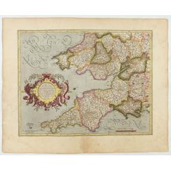
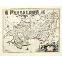
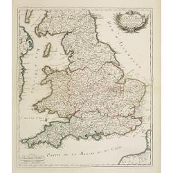
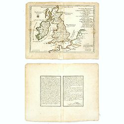
Cornubia, Devonia, Somersetus, . . .
A very nice map showing the south-western part of England. Mercator was born in Rupelmonde in Flanders and studied in Louvain under Gemma Frisius, Dutch writer, astronome...
Place & Date: Amsterdam, 1630
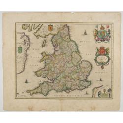
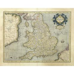
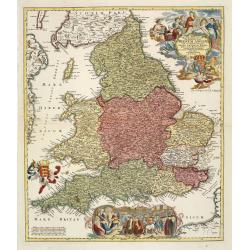
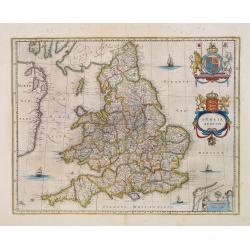
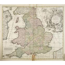
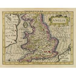
Anglia Regnum.
Janssonius' map of England and Wales was one of the new maps prepared by him in 1636. His map closely copies the similar map issued two years earlier by Willem Blaeu.. Th...
Place & Date: Amsterdam, 1642
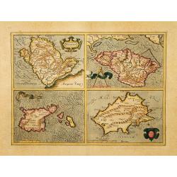
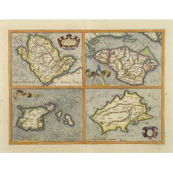
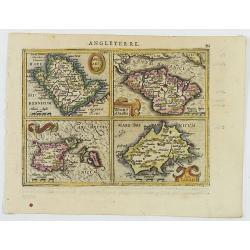
Anglesey. / Iarsay. / Carnesay. / Wight Vectis Olim.
Four maps on one sheet depicting the English islands Jersey, Guernsey, Wright and Alderney.
Place & Date: Amsterdam, 1630
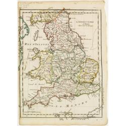
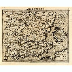
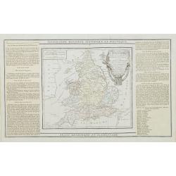
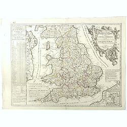
L'Angleterre.
Fine map of England and Wales. George Louis Le Rouge was active from 1740- till 1780 as a publisher, and was appointed engineer for the King of France. From his Atlas Nou...
Place & Date: Paris 1756
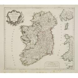
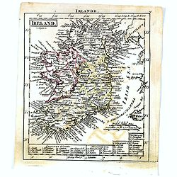
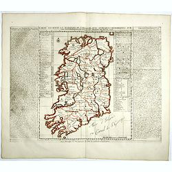
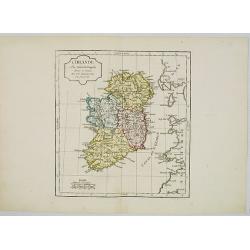
Royaume d'Irelande.. et subdivisé en Comtés.
Finely and crisply engraved map of Ireland.Venetian edition of Giles Didier Robert De Vaugondy's map from Atlas Universel printed in 1776-84.Ornamental title cartouche in...
Place & Date: Venice, 1776 - 1784
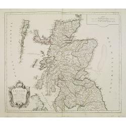
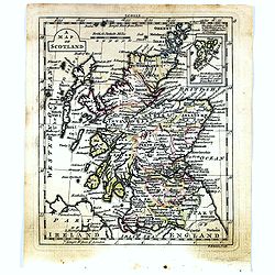
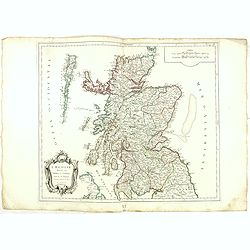
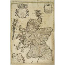
L'Ecosse divisée en Shires et Comtés.
Finely and crisply engraved map of Scotland.Venetian edition of Giles Didier Robert De Vaugondy's map from Atlas Universel printed in 1776-84.Ornamental title cartouche i...
Place & Date: Venice, 1776 - 1784
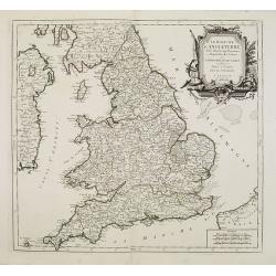
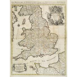
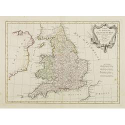
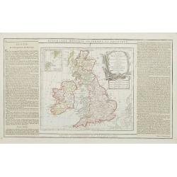
Le royaume d'Angleterre..subdivisé en Shires ou Comtés.
Finely and crisply engraved map of British Isles including the coasts of France and Ireland.Venetian edition of Giles Didier Robert De Vaugondy's map from Atlas Universel...
Place & Date: Venice, 1778 - 1784
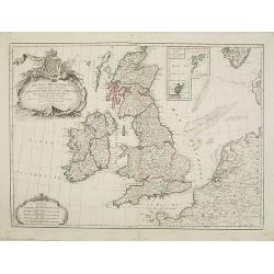
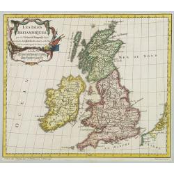
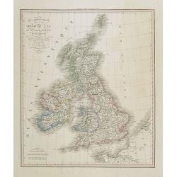
Les Isles Britanniques. . .
Detailed map encompassing present day British Isles.Venetian edition of the map by Bellin, to whom Santini gives credit in the cartouche.From "Atlas Universel" ...
Place & Date: Venice, 1776 - 1784
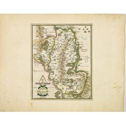
Penbrochia Comitatus et Comitatus Caermaridunum.
Attractive map of the country of Pembroke shire in UK by J. Blaeu. From a Dutch edition of "Atlas Maior" in beautiful color. With 13 coats of arms, the feathere...
Place & Date: Amsterdam, 1648
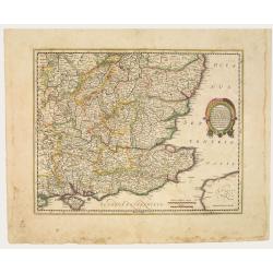
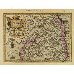
Warwicum Northamtonia Huntingdonia Cantabrigia..
Showing the south-eastern part of England.
Place & Date: Amsterdam, 1642
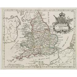
Carte du Royaume d' Angleterre . . .
Map of England and its counties, from Atlas moderne portatif composé de vingt-huit cartes sur toutes les parties du globe terrestre .. A l'usage des Colléges, des Pensi...
Place & Date: Paris, Prudhomme, Levrault, Debray, 1806
Anglesey. / Iarsay. / Carnesay. / Wight Vectis Olim.
Four maps on one sheet depicting the English islands Jersey, Guernsey, Wright and Alderney.
Place & Date: Amsterdam, 1629
Les Isles Britanniques..
A first state (of 2) dated 1762. Fine map of the British Isles, engraved by E.Dussy. Fine title cartouche upper left engraved by Arrivet. From his Nouvel Atlas Portatif .
Place & Date: Paris, 1762
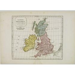
Anglia regnum.
Counties are shown in outline and named. The coast of Ireland is shown across the Irish Sea.Mercator was born in Rupelmonde in Flanders and studied in Louvain under Gemma...
Place & Date: Amsterdam, 1630
Le Royaume d'Angleterre distingué en ses provinces.
Fine map of England and Wales that is fully and richly engraved. Large and extremely decorative cartouche with angels, flags, seal of England, etc. Six distance scales wi...
Place & Date: Amsterdam, 1693
Les Isles Britanniques ou sont le Rme. D'Angleterre . . . Par G. De L'Isle. . . A Paris Chez Dezauche. . .
Uncommon late edition, (dated An 8, 1800 ) of this map of the British Isles prepared by DeL'Isle and published during the French Revolution by Dezauche / Buache. The bott...
Place & Date: Paris, 1800
Magnae Britanniae pars meridionalis in qua regnum Angliae. . .
Johann Baptist Homann's well-engraved map has a large decorative cartouche at top right and a large scene at bottom center showing a throned ruler, presumably George I, h...
Place & Date: Nuremberg, 1740
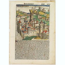
Tercia Etas Mundi. Folium.XLVI (A English town view)
Large woodcut depicting an imaginary English town (235x223mm.) and on verso the genealogy of King David.Page from the richest illustrated Incunable, the famous: Chronicle...
Place & Date: Nuremberg, 12 July 1493
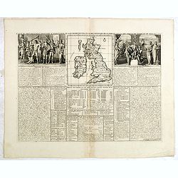
Carte du gouvernement militaire d'Angleterre où l'on représente l'état des officiers de guerre et celui des forces de terre et de mer.
Interesting sheet with a decorative map on the British Isles, with idyllic scenes showing councils of the various military officers of the British Isles, with descriptive...
Place & Date: Amsterdam, 1720
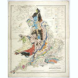
The Inland Navigation, Rail Roads, Geology and Minerals of England & Wales.
A beautifully color-coded and robustly labelled map describes the geology of England and Wales. The colors indicate particular rock materials in accordance with a key at ...
Place & Date: London, 1834
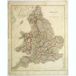
England.
A large and detailed steel engraved map of England, with each county divided by a different color. Many place names and physical features shown - it shows how densely pop...
Place & Date: London, 1839
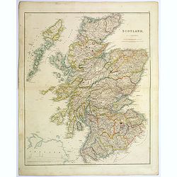
Scotland.
An attractive steel engraved map of Scotland, with each county divided by a different color. Many place names and physical features shown.The Arrowsmith family members we...
Place & Date: London, 1839
![[L'Hermite's fleet moors in the Solent for repairs.]](/uploads/cache/40472-250x250.jpg)
[L'Hermite's fleet moors in the Solent for repairs.]
In March 1623, a heavily armed fleet of 11 ships, under the command of Jacob l’Hermite, sailed from Holland with the ambitious hope of ‘destroying the Spanish in Amer...
Place & Date: Frankfurt, M.Merian, 1633

Angliae Regni florentissimi nova descriptio..
Fine general map of England derived from Mercator's 1564 map of the British Isles in 8 sheets.Dare to go in Black. All early maps were printed in black and white; many we...
Place & Date: Antwerp, 1598

Angliae, scotiae, et Hiberniae, sive Britannicar:insularum.
Fine general map of the British Isles and Ireland on horizontal projection with north to right of page. Derived from Mercator's 1564 map of the British Isles.Dare to go i...
Place & Date: Anwerp, 1598
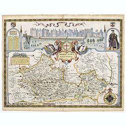
Berkshire Described.
A lovely map of Berkshire from the first Sudbury & Humble edition of John Speed’s “Theatre of the Empire of Great Britain”. The top of the map shows a panoramic...
Place & Date: London, 1612

Pascaart van de west cust van Engeland en Wales Van S. Davids Point tot de Moul van Dalway.
Rare Doncker's sea chart of the Irish Sea with the west Coast of England (Liverpool), the Island of Man and the western-most tip of Northern Ireland (Bangor) and Souther...
Place & Date: Amsterdam, 1660-1668
Parte settentrionale del regno d'inghilterra. . ./ Parte meridioçnale des regno d'inghilterra. . .
A beautiful and flamboyantly engraved two sheet map of British Isles, including four large cartouches and table of counties, towns, etc. Shows towns, mountains, rivers, l...
- $500 / ≈ €468
Place & Date: Venice, 1698
Ireland.
Uncommon miniature map of Ireland, engraved by J. Bayly for "A New General and Universal Atlas Containing Forty five Maps by Andrew Dury".This miniature atlas p...
- $50 / ≈ €47
Place & Date: London, 1761-1763
A map of Scotland.
Uncommon miniature map of Scotland, engraved by Thomas Kitching for "A New General and Universal Atlas Containing Forty five Maps by Andrew Dury".This miniature...
- $50 / ≈ €47
Place & Date: London, 1761-1763
Le royaume d'Angleterre..
Fine map of England and Wales. As well as country details, including the main post roads. Le Rouge was active from 1740- till 1780 as a publisher, and was appointed engin...
- $250 / ≈ €234
Place & Date: Paris, 1745
Carte Du Royame D'Angleterre..
Attractive map of England, ornated with a rococo title cartouche. Boundaries outlined in hand color.From theAtlas moderne ou collection de cartes sur toutes les parties d...
- $250 / ≈ €234
Place & Date: Paris, ca 1783
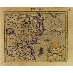
Ultonia Oriental.
Map depicting part of Ulster, with the south-western tip of Scotland in the upper right. From the first French-text edition of Jodocus Hondius' Atlas Minor.Shortly after ...
- $75 / ≈ €70
Place & Date: Amsterdam, 1608
Northumbr. Cumberladia Dunelm. Episcop.
A map of the most northern part of England, from the first French-text edition of Jodocus Hondius' Atlas Minor.Shortly after the publication of the big folio-atlases the ...
- $100 / ≈ €94
Place & Date: Amsterdam, 1608
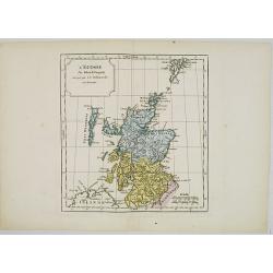
L' Ecosse.
Map of Scotland. By C. F. Delamarche, successor of Robert de Vaugondy, Geographer.
- $50 / ≈ €47
Place & Date: Paris, 1794 - 1806
Northumbria, Cumberlandia et Dunelmensis Episcopatus..
Showing the most northern part of England, including Sunderland.
- $400 / ≈ €374
Place & Date: Amsterdam, 1642
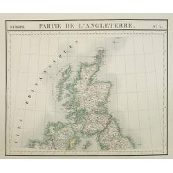
Europe. Partie de l'Angleterre. N°7.
Detailed map including Northern part of England.From his famous Atlas Universel . This atlas was one of the most remarkable world atlases ever produced, anticipating the ...
- $100 / ≈ €94
Place & Date: Brussels, 1825-1827
Udrone Irlandiae in Catherlagh Baronia.
A detailed map of the Barony of Udrone (modern Idrone) in County Carlow, Ireland The title is surrounded by a strapwork design cartouche topped with calipers & a mile...
- $200 / ≈ €187
Place & Date: Amsterdam, 1630

Udrone.
Map depicting present-day County Carlow in Leinster Province & Catherlaugh which is now Carlow. From the first French-text edition of Jodocus Hondius' Atlas Minor.Sho...
- $150 / ≈ €140
Place & Date: Amsterdam, 1608
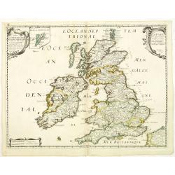
Carte Generale des Royaume d'Angleterre Escosse et Irlande Avecq les Isles circonvoisines Conues toutes soubs le nom de Britanniques / Nouvellement dressee et tiree de Cambdene Spede & autres Par N. Sanson geogr.e Ord.re du Roy
Fine map of the British Isles. The map was first published by Tavernier and later by Mariette. This edition carries the date 1640 and the address of Pierre Mariette: rue ...
- $350 / ≈ €328
Place & Date: Paris, 1640-1657
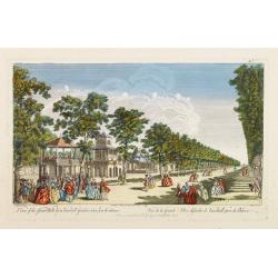
A View of the Grand Walk &c in Vauxhall gardens taken from the Entrance. Publish'd according to Act of Parliament..
So-called optical print illustrating Vauxhall gardens.In the eighteenth and nineteenth centuries, there were many popular specialty establishments in Paris, Augsburg and ...
- $200 / ≈ €187
Place & Date: London, 1759
Anglia Regnum.
Willem Blaeu was the first publisher to bring out a new map of England and Wales. The outline and place names are taken from Speed with county boundaries marked but no bo...
- $500 / ≈ €468
Place & Date: Amsterdam, 1650
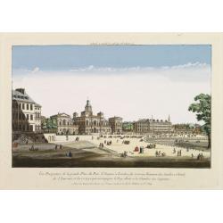
Vüe Perspective de la grande Place du Parc St. Jacques à Londres, du nouveau Batiment des Gardes a Cheval, de l'Amirauté..
So-called optical print illustrating a cortege of subjects accompanying the king to the House of Lords along the Horse guards Road in St. James's Park, in London.The Old ...
- $200 / ≈ €187
Place & Date: Paris, 1760
Warwicum Northampton, Huntingdon Cantabr etc.
Showing the south-eastern part of England. From his Atlas Minor. French text on verso.
- $100 / ≈ €94
Place & Date: Amsterdam, c.1630
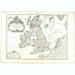
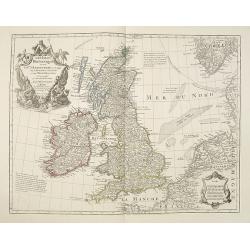
Les Isles Britanniques Comprenant les Royaumes D'Angleterre, D'Ecosse et D'Irlande divisée en grands provinces. . .
Detailed map encompassing present day British Isles. An inset in the upper right details the Shetland and Orkney Islands. Venetian edition of the map by Janvier, to whom ...
- $200 / ≈ €187
Place & Date: Venice, 1776 - 1784
L'Ecosse divisée en Shires et Comtés.
Finely and crisply engraved map of Scotland.Venetian edition of Giles Didier Robert De Vaugondy's map from Atlas Universel printed in 1776-84.Ornamental title cartouche i...
- $250 / ≈ €234
Place & Date: Venice, 1776 - 1784

Itinera Varia Auctoris.
From A Natural History of Uncommon Birds, and of some other rare and undescribed Animals, Quadrupeds, Reptiles, fishes, insects, &c.. The map shows Edwards' journeys ...
- $300 / ≈ €281
Place & Date: London, 1746
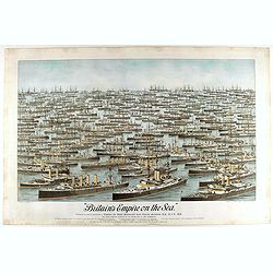
Britain's Empire on the Sea. Dedicated to Captain the Right Honourable Lord Charles Beresford...
A very decorative and large chromolithographed plate showing all the effective strength of the British navy with the name and class of each ship shown beneath, except for...
- $750 / ≈ €702
Place & Date: Portsea, ca. 1897
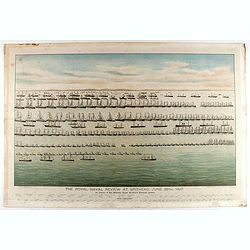
The Royal Naval review at Spithead, June 26th, 1897. In Honour of Her Majesty Queen Victoria's Diamond Jubilee.
A very decorative and large chromolithographed plate showing a line up of international vessels at Spithead, June 26th, 1897 In Honour of her Majesty Queen Victoria'a Dia...
- $750 / ≈ €702
Place & Date: Portsea, ca. 1897

The Wonderground Map of London.
A large and pictorially striking 'Wonderland' advertising poster on behalf of the London Underground, published in the late 1920s. The poster was very popular, and ran fo...
- $4000 / ≈ €3743
Place & Date: London, ca 1927
Les Isles Britanniques..
An attractive map of the British Isles including an inset of the Orkney and Shetland Islands. Finely embellished with a large title cartouche.The map is flanked by two co...
- $90 / ≈ €84
Place & Date: Paris, 1790
L'Angleterre divisée en 5 grandes Parties. . .
A very attractive map of England and Wales showing its 52 counties and the major cities as well as five large regional divisions.Finely embellished with a large title car...
- $100 / ≈ €94
Place & Date: Paris, 1790
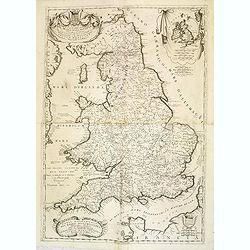
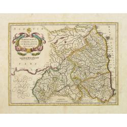
Regni Angliae et Wallae principatus Tabula, divisa in LII Regiones. . .
A detailed and decorative map of England, with an attractive uncolored title cartouche. The map is a re-issue of Carolus Allard's map. The elaborate title cartouche in th...
- $400 / ≈ €374
Place & Date: Amsterdam c. 1744
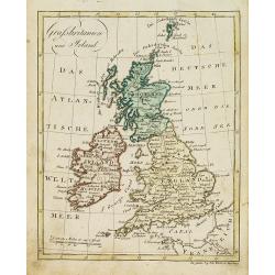
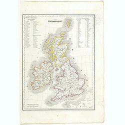
Grossbritanien und Irland.
Nice small map of the British isles and Ireland by Johannes Walch in his rare Allgemeiner Atlas Nach den bewährsten Hülfsmitteln und astronomischen Ortsbestimungen…, ...
- $50 / ≈ €47
Place & Date: Augsburg, 1812

Pascaert van Engelant Van t'Voorlandt tot aen Blakeney waer in te sien is de mont vande Teemse.
Two charts on one sheet. One decorative sea chart of the southeast coast of England with an inset of the Thames till London, embellished with two title cartouches, a ship...
- $750 / ≈ €702
Place & Date: Amsterdam, 1666
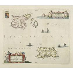
Sarnia Insula vulgo Garnsey et Insula Caesarea venacule Jarsey
Fine map depicting the English islands of Jersey and Guernsey is entitled : "Sarnica Insulavulgo Garnsey et Insula Caesarea vernacule Jarsey". In the cartouche...
- $475 / ≈ €444
Place & Date: Amsterdam, 1660
Le Royaume d'escosse divise en partie septentrionale et meridionale. . .
Fine map of Scotland with a decorative title and scale cartouche.Alexis-Hubert Jaillot (1632-1712), was a French cartographer. He joined the Sanson heirs and redrew Nicol...
- $500 / ≈ €468
Place & Date: Amsterdam, 1692

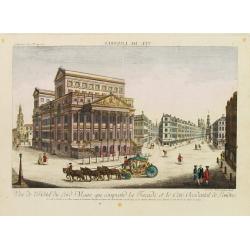
Vue de l Hotel du Lord Maire, qui comprend la Façade, et le Cot' Occidental de Londres.
Shows the famous Lord Mayor's coach driving through London. The Lord Mayor's coach is famous for its role in the Lord Mayor's Show, which is one of the longest establishe...
- $100 / ≈ €94
Place & Date: Augsburg, 1750
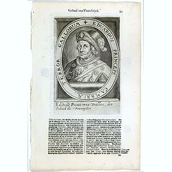
Eduardus Princeps Cambriae, Terror Gallorum.
The engraving depicts a half length oval portrait of Edward Prince of Wales. Nicolaes de Clerck (de Klerc) was active as engraver and publisher in Delft from 1599-1621.In...
- $25 / ≈ €23
Place & Date: Amsterdam, Cloppenburch, 1621
Le Royaume d'Angleterre.
An attractive map centered on England, Wales and the southern part of Scotland. The very decorative cartouche includes a dedication to Jacques II Roy d'Angleterre, d'Esco...
- $650 / ≈ €608
Place & Date: Paris, 1689
Carte ancienne et moderne de l'Irlande, avec quelques remarques sur son gouvernement . . .
Map of Ireland, based upon the ancient and modern cartographic information as of the beginning of the 18th Century. From Chatelain's monumental 7 volume "Atlas Histo...
- $200 / ≈ €187
Place & Date: Amsterdam, 1720
Iles Britanniques.
Detailed British Islands map, prepared by Charles V. Monin (fl.1830-1880) a French cartographer of Caen and Paris. Published in Atlas Universel de Géographie Ancienne &a...
- $25 / ≈ €23
Place & Date: Paris, 1845
![[The United Kingdom - Sweden, Norway, Denmark].](/uploads/cache/46169-250x250.jpg)
[The United Kingdom - Sweden, Norway, Denmark].
Alexey Afinogenovich Ilyin was a lieutenant general and cartographer (1832-1889). In 1856, after graduating from the Academy of the General Staff, he was at the military ...
- $50 / ≈ €47
Place & Date: St. Petersburg, 1899
Anglia.
Map of England, from the first French-text edition of Jodocus Hondius'' Atlas Minor.Shortly after the publication of the big folio-atlases the need was apparently felt fo...
- $150 / ≈ €140
Place & Date: Amsterdam, 1608
Anglesey Ins. / Wight.. / Ins. Garnesey. / Ins. Iarsey.
A reduced version of Mercator's folio map with four maps on one sheet depicting the English islands of Jersey, Guernsey, Wright and Alderney.Each map is embellished with ...
- $150 / ≈ €140
Place & Date: Amsterdam, 1608
L' Irlande.
Map of Ireland. By C. F. Delamarche, successor of Robert de Vaugondy, Geographer.
- $90 / ≈ €84
Place & Date: Paris, 1794 - 1806
Les Isles Britanniques.
Map of British Isles. By C. F. Delamarche, successor of Robert de Vaugondy, Geographer.
- $80 / ≈ €75
Place & Date: Paris, 1794 - 1806
Iles Britanniques ou Royaume-Uni de la Grande Bretagne . . .
Detailed map of United Kingdom, prepared by A. H. Basset, rue Saint-Jacques, no. 64, Paris and published in Atlas classique et Universel de Géographie . . . .The engrave...
- $90 / ≈ €84
Place & Date: Paris, A.H. Basset, 1828
Vue et perspective d'un Jardin du Roy d'Angleterre aux environs de Londres.
So-called optical print of one of the King's Royal Gardens in the London vicinities.Published by the brothers Chéreau, active in Paris at rue St. Jacques au dessus de la...
- $150 / ≈ €140
Place & Date: Paris, 1760
Prospectus Purfleet ad Tamesim in Comitatu Essex Representant le Purfleet sur la Tamise dans le Comté d'Essex. 21e VUE d'Optique.
A so-called optical print of the vessel Purfleet navigating on the River Thames in Essex, England. Published by the brothers Chéreau, active in Paris at rue St. Jacques...
- $300 / ≈ €281
Place & Date: Paris, 1760
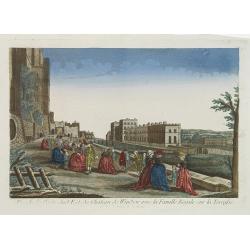
Vue de la Partie Sud Est du Château de Windsor avec la Famille Royale sur la Terrasse. Et vue du Palais de la Reine.
A so-called optical print view of the Royal family at the terrace of the South East wing of Windsor Castle as well as the Queen's Palace. Published by the brothers Chére...
- $200 / ≈ €187
Place & Date: Paris, 1760
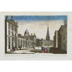
Universatis ae Reginae Collegiorum prospectus Oxfordiae Représentant le College de l'Université, et celui de la Reine a Oxford. 63 Vue d'optique.
A so-called optical print of Queens College on High Street in Oxford. As most optical prints, due to the fact that they are used to be looked at in a mirror, the subject ...
- $275 / ≈ €257
Place & Date: Paris, 1760
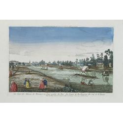
Vue d'une des Maison de Plaisance et d'une partie du Parc du Comte de Burlington du Coté de la Tamise.
A so-called optical print of Burlington County and the River Thames. Published by the brothers Chéreau, active in Paris at rue St. Jacques au dessus de la Fontaine St. S...
- $225 / ≈ €211
Place & Date: Paris, 1760
Vue de l'Hotel du Lord Maire, qui comprend.. (London)
In the eighteenth and nineteenth centuries there were many popular speciality establishments in Paris, Augsburg and London which produced optical viewing devices and spec...
- $300 / ≈ €281
Place & Date: Augsburg 1750
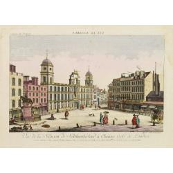
Vue de la Maison de Northumberland a Charing Cross. . .
In the eighteenth and nineteenth centuries there were many popular speciality establishments in Paris, Augsburg and London which produced optical viewing devices and spec...
- $300 / ≈ €281
Place & Date: Augsburg 1750
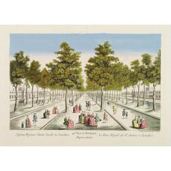
40e Vue d'Optique Representant Le Parc Royal de St. James a Londres.
So-called optical print illustrating a perspective view of Saint James Park, in London.In the eighteenth and nineteenth centuries there were many popular speciality estab...
- $250 / ≈ €234
Place & Date: Paris, 1760
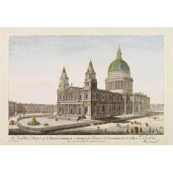
The North West Prospect of S. Pauls Cathedral in London.
Uncommon optical print illustrating a view of St. Paul's Cathedral in London.In the eighteenth and nineteenth centuries there were many popular speciality establishments ...
- $275 / ≈ €257
Place & Date: Paris, 1760
Les Isles Britanniques ou sont les Royaumes . . .
An interesting small map of the British islands by Nicolas de Fer. From his rare "Petit et Nouveau Atlas". The first edition was published in 1697 and was repub...
- $75 / ≈ €70
Place & Date: Paris, 1705
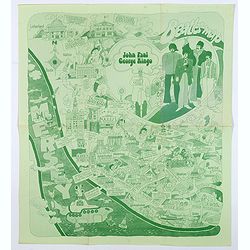
Beatles Map.
A lovely example of the scarce 'Beatles Map' of Liverpool, published in 1974 to commemorate the buildings and places where the Beatles started their stellar careers. The ...
- $750 / ≈ €702
Place & Date: Liverpool, 1974
Provincia ecclesiastica di Westminster Londra in Inghilterra (Tav LXXXIV)
A large-format map of the British Isles with its different dioceses. The map is finely engraved and beautifully colored and was prepared by Girolamo Petri, a lawyer who s...
- $300 / ≈ €281
Place & Date: Rome, 1858