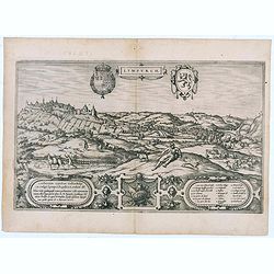
Lympurch. (Limburg)
Very desirable and early town-plan of the city of Limburg in Belgium with its fortifications at the end of the 16th century.From volume one of the greatest publication in...
- $250 / ≈ €234
Place & Date: Cologne, 1575
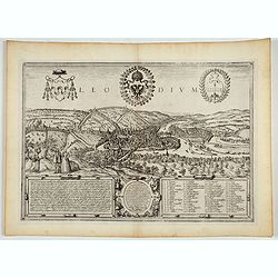
Leodium. (Luik or Liège)
Very desirable and early town-view of Liège, which shows the city with the Meuse flowing in its favorable location amongst gentle hills, sturdy trees and fertile fields....
- $300 / ≈ €281
Place & Date: Cologne, (1572) 1577
![Anverpia, nobile in Barbantia oppidum, parrim maritimum . . . [Antwerp]](/uploads/cache/26518-250x250.jpg)
Anverpia, nobile in Barbantia oppidum, parrim maritimum . . . [Antwerp]
The bird's-eye plan provides an excellent view of the citadel, city, docks and fortifications. The city was defended by a line of fortification and a moat constructed und...
Place & Date: Cologne, 1585
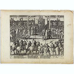
Wie ist das gluck so gar ungleich . . . Plate 18.
Early print showing a hanging in Brabant on 11 February 1620.Plate from the series about the " Eighty Years' War" or the independence war of Holland against Spa...
- $80 / ≈ €75
Place & Date: Cologne, ca. 1590
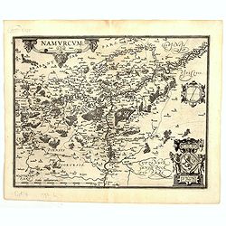
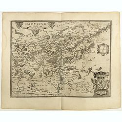
Namurcum Comitatus.
Prepared by Jacques Surhon in 1555. His manuscript map was for security reason not published. Only in 1579, when Antwerp was independent for a short time, Ortelius used a...
Place & Date: Antwerp, 1598
Namurcum Comitatus.
Prepared by Jacques Surhon in 1555. His manuscript map was, for security reasons not published. Only in 1579, when Antwerp was independent for a short time, Ortelius used...
Place & Date: Antwerp, 1598
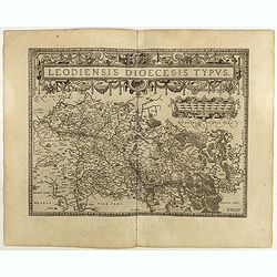
Leodiensis Diocesis Typus.
East to the top. Centered on Liege, including the southern part of Dutch Limburg. Prepared by Jan van Schille.Dare to go in Black. All early maps were printed in black an...
Place & Date: Antwerp, 1598
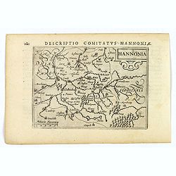
Hannonia.
An attractive miniature map of the Belgian, region of Hainaut, published by Petrus Bertius, in Amsterdam at the beginning of the seventeenth century. It features a small ...
Place & Date: Amsterdam, 1606
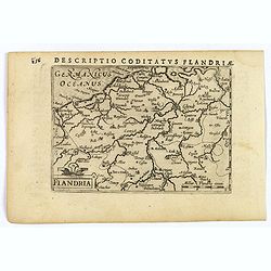
Flandria.
A lovely set of miniature map of Flanders. With an attractive strap-work title, and with detailed topography and information. Bertius (1565-1629) was a Flemish cartograph...
Place & Date: Amsterdam, 1606
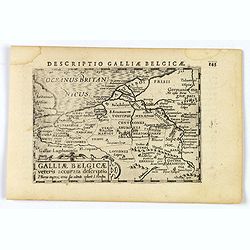
Descriptio Galliae Belgicae.
A decorative miniature map of a section of ancient France, and that of Belgium. Features a nice strap-work title, shows rivers and settlements. From the Bertius atlas Tab...
- $100 / ≈ €94
Place & Date: Amsterdam, 1606