
Plan de Constantinople, non compris ses faubourgs. Grave d'apres les documents du ministere de la Guerre par E. Olivier.
A very rare lithographic town-plan of Istanbul, Scale 98 yards to one inch., printed in Pera, Istanbul by E. Olivier. The ornate design on the top of the title is a tugh...
Place & Date: Péra, Istanbul, 1851
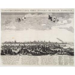
Constantinopolitanae urbis effigies ad vivum expressa.
A rare panoramic town-view of Istanbul with over the whole length of the lower part 3 columns of poems in Latin, Dutch and French and a numbered key 1-29 to the principal...
Place & Date: Amsterdam, 1660

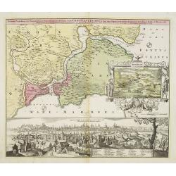
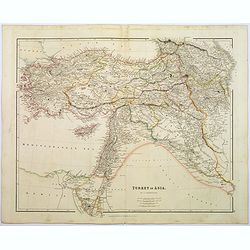
A Map of the Environs of Constantinople Drawn from a great number of accurate astronomical & geographical manuscripts and printed documents, by A. Arrowsmith 1801 and 1804.
Arrowsmith’s large and detailed map of the Ottoman Empire and the Black Sea, with Cyprus, Crete and the Greek Islands in the Mediterranean Sea, Albania, Bosnia and Herz...
Place & Date: London, No.10 Soho Square, 4th September 1804
Constantinople ville de Romanie et capitale de l'Empire des Turcs.
A very decorative and extremely rare of Istanbul, including a numbered legend in lower part. Published by Jacques Chéreau, (1688 - 1776). Engraved by Aveline and first ...
Place & Date: Paris, ca.1750

Constantinopolis.
A spectacular woodcut panorama of the ancient city of Constantinople, proporting to show the pre-Turk city (for example naming St Sophia). (235x522mm).One of the earliest...
Place & Date: Nuremberg, 12 July 1493
Constantinopolis.
Extremely rare panoramic town-view of Istanbul published by Frederick de Wit. With a numbered key (1-17) to principal places in town and a poem in Latin, Dutch, English a...
- $4000 / ≈ €3743
Place & Date: Amsterdam, 1680

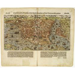
Constantinopolitanae urbis effigies ad vivum expressa, quam Turcae Stampoldam vocant. A° MDCXXXV.
Large, decorative view of the city of Constantinople, with legend across the bottom. It is beautifully engraved with quaint scenes of everyday life, including hunters wit...
Place & Date: Frankfurt, 1635
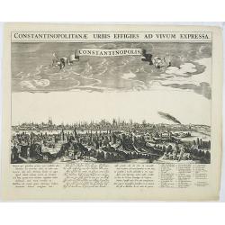
Constantinopolitanae urbis effigies ad vivum expressa.
Extremely rare panoramic view of Istanbul published by Rombout van den Hoeye. With a numbered key (1-29) to principal places in town and a Latin, Dutch, and French poem. ...
- $3500 / ≈ €3275
Place & Date: Amsterdam, 1650
Constantinopolis Constantinopel.
Very rare and decorative panoramic view of Istanbul prepared by Friedrich Berhard Werner and published by Martin Engelbrecht. The engraving is done by Johann Georg Ringli...
- $3500 / ≈ €3275
Place & Date: Augsburg, M.Engelbrecht, ca.1730-1740

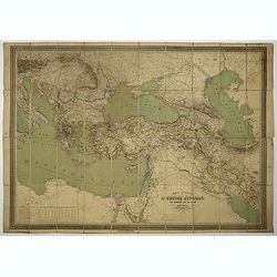
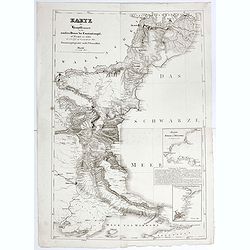
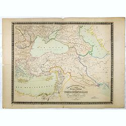
Carte générale de L'Empire Ottoman en Europe et en Asie dressée par Henri Kiepert . . .
Large School wall map of Turkish Empire printed in chromo-lithography. Published by Dieter Reimer and printed by Ferdind Barth in Berlin. This rare map has two insets in ...
Place & Date: Berlin, Verlag von Dietrich Reimer, 1867

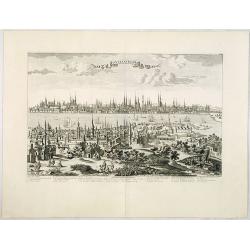
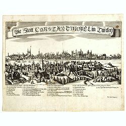
(Untitled view from Scutari with a view of Constantinople)
Panoramic view from Scutari with a view of Constantinople in the distance, after a design by Johann Schranz. Published by J. Missiriè.
Place & Date: Paris, 1860
![Veduta di Istambul. [Gouache]](/uploads/cache/45368-250x250.jpg)
Veduta di Istambul. [Gouache]
Very decorative view depicting Istanbul, in the style of Neapolitan gouaches. Features different Mosques and the shores of the Bosporus. Many ships, small and large, are ...
Place & Date: Italy ?, ca. 1870
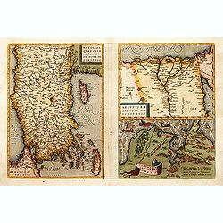
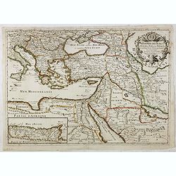
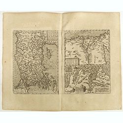
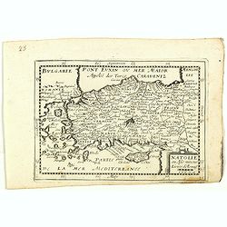
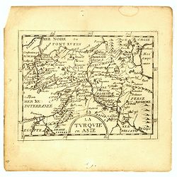
1) Natoliae,.. 2) Aegypti recentior.. 3) Carthaginis..
To the left a map of Turkey. Oriented with west at bottom. Right side of sheet contains a map of northern Egypt showing the Nile River delta, and a map the vicinity of Tu...
Place & Date: Antwerp, 1570-1609
Constantinopolitanae urbis effigies ad vivum expressa.
Extremely rare panoramic view of Istanbul published by Jacob Koppmayr. With a numbered key (1-29) to principal places in town. Jacob Koppmayr was a printer and publisher ...
- $900 / ≈ €842
Place & Date: Augsburg, 1689
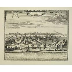
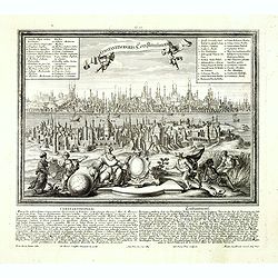
Accurate Vorstellung der Orientalisch Kayserlichen Haupt- und Residenz-Stadt Constantinopel samt ihrer Gegend und Zweyen . . .
The upper part shows Constantinople with adjoining regions. The view shows the former Christian church Hagia-Sophia, the Blue Mosque, three Egyptian obelisks, Sultan Sule...
- $1250 / ≈ €1170
Place & Date: Nuremberg 1720

Natoliae.. Aegypti recentior.. Carthaginis ( 3 maps on 1 sheet)
Three maps on one sheet. Map to the left east to the top. Detailed map Turkey, including Cyprus and Crete. Also map of the Nile delta and another map of Tunis. From "...
- $750 / ≈ €702
Place & Date: Antwerp, 1587
Carte général de L'Empire Ottoman en Europe et en Asie. . . dressée par Henri Kiepert.
Large School wall map of Turkish Empire printed in chromo-lithography. Published by Dieter Reimer and printed by Ferdind Barth in Berlin.This rare map has two insets in l...
- $700 / ≈ €655
Place & Date: Berlin, Dieter Reimer, 1867
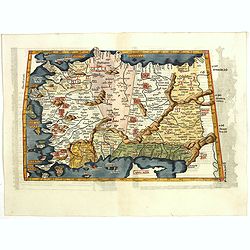
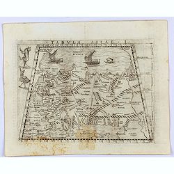
Tabula I Asiae.
Ptolemaic map of Turkey.From Lorenz Fries' edition of Ptolemy's Geographia, largely based on the 1513 map by Waldseemuller. "The elaborate Renaissance woodcut panels...
- $750 / ≈ €702
Place & Date: Vienna, 1490, 1535
![Constatinopolis. [Istanbul]](/uploads/cache/26996-250x250.jpg)
Constatinopolis. [Istanbul]
Panoramic town-view of Constantinople (Istanbul). Woodcut published in the so-called pirate edition of the "small Schedel" in Augsburg, 1497, Latin edition. Ori...
Place & Date: Augsburg, Johann Schönsperger, 1497
Selling price: $500
Sold in 2009
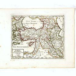
L'Empire des Turcs en Europe, en Asie et en Afrique.
A nice map showing the Turkish Empire, including an inset map of kingdom of Alger. Extending from Italy and the Eastern Mediterranean in the west to the Caspian Sea and P...
- $550 / ≈ €515
Place & Date: Paris, 1686
Natoliae Sive Asia Minor.
Map of Turkey, also depicting Cyprus.
- $750 / ≈ €702
Place & Date: Amsterdam, 1610

Vue du sperbe Temple de St.Sophie .. a Constantinople.
A fanciful depiction of the Aya Sofya in Istanbul. In the eighteenth and nineteenth centuries there were many popular speciality establishments in Paris, Augsburg and Lon...
Place & Date: Paris, 1800
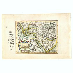
Turcicum Imperium.
Early map of Turkey, the Arabian peninsula and eastern part of the Mediterranean.From the English edition of Mercator's Atlas Minor. This edition 1635. English text on ve...
- $400 / ≈ €374
Place & Date: Amsterdam, 1635
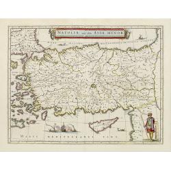
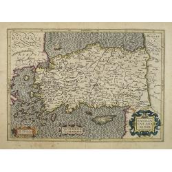
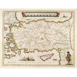
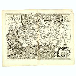
Natolia, quae olim Asia minor.
A finely designed map of Turkey and Cyprus from the great Blaeu family of Amsterdam. The decoration consist of a colored title cartouche, sea monsters, a naval engagement...
- $450 / ≈ €421
Place & Date: Amsterdam, 1658
Constantinopel des Griechischen Keijserthumbs Hauptstatt im Lande Thracia am Meere gelegen.
Detailed town view of the Golden Horn of Constantinople. The city plan depicts the markets, homes, palaces and churches, including the famous Hagia Sophia, shown prior to...
Place & Date: Basle, 1550-1580
Selling price: $550
Sold in 2015
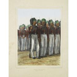
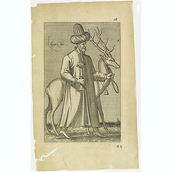
Infanterie Turque (chasseurs). 7 novembre 1837.
Beautiful lithography by Auguste Raffet (1804 -1860 ) and printed by Auguste Bry.
Place & Date: Paris, Gihaut frères, 1848
Karte der Hauptstraßen von der niederen Donau bis Constantinopel … / Spezialkarte des Meerbusens von Burgas . ..
Uncommon map of the routes of the eastern part of the Balkan Peninsula. prepared by C. Zirbeck The map has two insets "Meerbusen von Burgas oder Mesambri" (Bay ...
- $550 / ≈ €515
Place & Date: 1820
Natoliae Quae Olim Asia Minor, Nova de Scriptio / Carthaginis Celeberrimi Sinus Typus / Aegypti re Centior de Scriptio
Three detailed regional maps by Ortelius from his "Theatrum Orbis Terrarum", the world's first modern atlas.The first map covers Asia Minor, Cyprus and the East...
Place & Date: Antwerp, 1598
Natolia, quae olim Asia minor.
A finely designed map of Turkey and Cyprus from the great Blaeu family of Amsterdam. The decoration consist of a colored title cartouche, sea monsters, a naval engagement...
Place & Date: Amsterdam, 1635
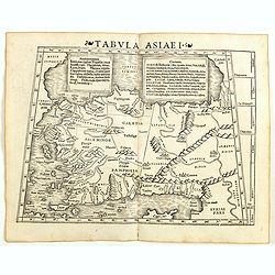
Tabula Asiae I.
Gastaldi's map of Asia Minor and the Bosporus Straits, based upon Ptolemy.It is one of the earliest obtainable maps of the region .From Giacomo Gastaldi's Atlas of 1548 w...
- $400 / ≈ €374
Place & Date: Venice, 1548
Natoliae Sive Asia Minor.
From the first edition. Map of Turkey, also depicting Cyprus.
- $350 / ≈ €328
Place & Date: Amsterdam, 1606
Natoliae.. Aegypti recentior.. Carthaginis (3 maps on 1 sheet)
Map to the left east to the top. Detailed map Turkey, including Cyprus and Crete. Also map of the Nile delta and another map of Tunis. From "Theatrum Orbis Terrarum&...
- $500 / ≈ €468
Place & Date: Antwerp, 1609-1641
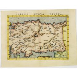
Natolia nuova tavola.
Uncommon first edition of this early map of Turkey.Girolamo Ruscelli's edition of Ptolemy's Geographia included newly engraved copperplates by Giulio and Livio Sanuto. Th...
- $375 / ≈ €351
Place & Date: Venice, 1561
Tabula Asiae I (Turkey)
The first edition of Munster's map of Turkey, based upon Claudius Ptolemy which appeared in his "Geographia Universalis", first published in 1540. The Geographi...
- $500 / ≈ €468
Place & Date: Basel, Heinrich Petri, 1545
![[Map of Turkey]](/uploads/cache/31502-250x250.jpg)
[Map of Turkey]
Page with an early representation of Turkey with Cyprus and Syria. This text page with a fine wood block printed map is from the rare work "C. Iulii Solini Polyhisto...
- $275 / ≈ €257
Place & Date: Basle, Michael Isengrin, 1544
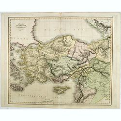
Turkey in Asia.
A lovely looking steel engraved map of Turkey in Asia. Map extent is Asia Minor, Syria, Holy Land, across to the Caucasian peoples that inhabit the lands between the Blac...
Place & Date: London, 1839
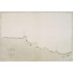
Carte de la Mer Noire. (1e Feuille). Du Bosphore à Mangalia et du Bosphore au Cap Kerempeh.
Very detailed chart of the Turkish part of the Black Sea including the towns of Constantinople (Istanbul) , Bourgas. Showing soundings in meters, lighthouses are marked w...
Place & Date: Paris, 1860, updated for 1870
Natolie ou Asie mineur, Lieües d'Alemag.
Rare map of Turkey and Cyprus published by Jollain in 1667. Published in "Trésor Des Cartes Geographiques Des Principaux Estats de Lunivers".This atlas is base...
- $250 / ≈ €234
Place & Date: Paris, 1667
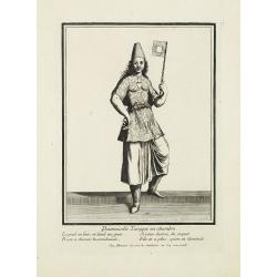
Damoiselle Turcque en chambre. . .
Beautiful engraving by Henri Bonnart (1642?-1711) vis-à-vis les Mathurins au Coq. Printed with the privilege of the King.
- $200 / ≈ €187
Place & Date: Paris, 1690
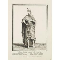
Femme Turque vestue a la moresque.
Beautiful engraving by Henri Bonnart (1642?-1711) vis-à-vis les Mathurins au Coq. Printed with the privilege of the King.
- $200 / ≈ €187
Place & Date: Paris, 1690
Das Osmanische asien oder die Asiatische Türkey. . .
Decorative map showing 'Asia Minor' with its neighboring countries. Prepared by Karl Ferdinand Weiland The eastern part of the Mediterranean Sea with Cyprus is as well sh...
- $200 / ≈ €187
Place & Date: Weimar, 1836-1838
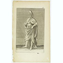
(Grand dame Turque. 45)
Sought-after copper engraved plate of a woman from Turkey. Plate from Laonikos Chalcocondyle’s "L'histoire de la décadence de l'empire grec et establissement de c...
Place & Date: Paris, Mathieu Guillemot, 1650
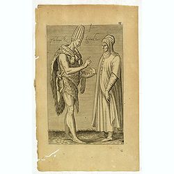
Torlaqui Religieux Turc. ( 25 )
Sought-after copper engraved plate taken from Laonikos Chalcocondyle’s "L'histoire de la décadence de l'empire grec et establissement de celuy des Turcs." by...
Place & Date: Paris, Mathieu Guillemot, 1650
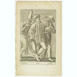
Les Yurongnes. (18)
Sought-after copper engraved plate taken from Laonikos Chalcocondyle’s "L'histoire de la décadence de l'empire grec et establissement de celuy des Turcs." by...
Place & Date: Paris, Mathieu Guillemot, 1650

Azamoglan Rustique .(12)
Sought-after copper engraved plate taken from Laonikos Chalcocondyle’s "L'histoire de la décadence de l'empire grec et establissement de celuy des Turcs." by...
Place & Date: Paris, Mathieu Guillemot, 1650
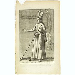
Habit et Manière ancienne des Peiches ou Laquais du Grand Seigneur. (14)
Sought-after copper engraved plate taken from Laonikos Chalcocondyle’s "L'histoire de la décadence de l'empire grec et establissement de celuy des Turcs." by...
Place & Date: Paris, Mathieu Guillemot, 1650

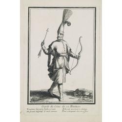
Iannissaire Allant à la Guerre. (9)
Sought-after copper engraved plate from Laonikos Chalcocondyle’s "L'histoire de la décadence de l'empire grec et establissement de celuy des Turcs." by Thoma...
Place & Date: Paris, Mathieu Guillemot, 1650
Iannissaire ou Ianissarler Soudart a Pied de la Garde Ordinaire du Grand Seigneur. (8)
Sought-after copper engraved plate from Laonikos Chalcocondyle’s "L'histoire de la décadence de l'empire grec et establissement de celuy des Turcs." by Thoma...
Place & Date: Paris, Mathieu Guillemot, 1650
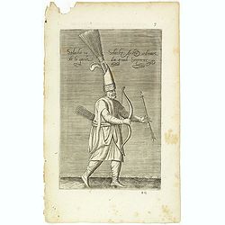
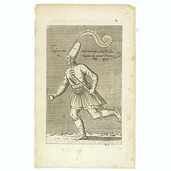
Solachi ou Solacler, Archer Ordinaire de la Garde du Grand Seigneur. (7)
Sought-after copper engraved plate taken from Laonikos Chalcocondyle’s "L'histoire de la décadence de l'empire grec et establissement de celuy des Turcs." by...
Place & Date: Paris, Mathieu Guillemot, 1650
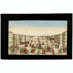
Imaginary view of a square with Muslims festival.
Imaginary view of a square with Muslims festival. A so called optical print.
- $200 / ≈ €187
Place & Date: Paris, ca. 1750
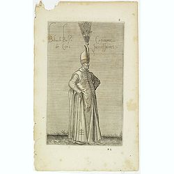
Boluch Bassi Capitaine de Cent Janissaires. (6)
Sought-after copper engraved plate from Laonikos Chalcocondyle’s "L'histoire de la décadence de l'empire grec et establissement de celuy des Turcs." by Thoma...
Place & Date: Paris, Mathieu Guillemot, 1650
Die Asiatische Turkey begreift in sich Natolien, Georgien, Armenien, Mesopotamien Syrien, und Arabien. . .
Map of Turkey bordered by the Black Sea to the north, Syria and Sinai Peninsula to the south, Turkey in Europe to the west, with a small title cartouche. Explanatory text...
- $200 / ≈ €187
Place & Date: Augsburg, 1789
Turquie en Asie, suivant les nouvelles observations..
Uncommon edition of this map of Turkey, Holy Land, Armenia, including Cyprus. With decorative title cartouche lower left corner.This example is unusual in having the addi...
- $200 / ≈ €187
Place & Date: Leiden, 1728
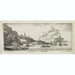
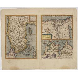
Satalia nel arcipelago. (Antalya)
Magnificent bird's eye-town-view of Antalya. Engraved by Lucas Vostermans II, who was born in 1624, in the same year when the family moved to England for six years. He wa...
- $150 / ≈ €140
Place & Date: Antwerp, c.1690
Turkey in Asia: or Asia Minor &c.
Herman Moll's map of the Turkish Empire in Asia, published in London during the first half of the eighteenth century. It shows the eastern Mediterranean, including Crete ...
- $150 / ≈ €140
Place & Date: London, ca 1729
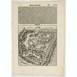
Sexta Etas Mudi. (With view of Sabatz.) Folio CCLIII
A imaginary view of Sabatz, Turkey: however the earliest obtainable view of this period.Further including presentations of the popes Sixtus IV and Innocentius VIII. Pag...
- $200 / ≈ €187
Place & Date: Nuremberg, 12 July 1493
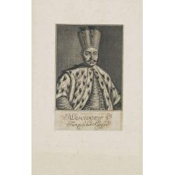
Mahomet V. Türkischer Kayser.
Portrait of Mahomet V. son of Mustapha II. succeeded in 1730, on the deposition of his uncle, Achmet III.Mahomet was more respectable for his pacific disposition, than hi...
- $150 / ≈ €140
Place & Date: Germany, c. 1720

Turckschemoniken die onder den goddelycken. . .
Decorative picture of three dervishes dancers. Their whirling dance, also known as the sema, is a serious religious ritual performed by Muslim priests in a prayer trance ...
Place & Date: Antwerpen, Michiel Cnobbaert, 1673
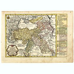
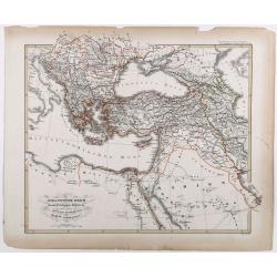
Carte physique et politique de la Turquie d'Europe et d'Asie contenant la Syrie, une partie de l'Egypte . . .
A detailed map including Turkey, Greece, Black Sea, Holy Land, Georgie, Iran, Iraq, Armenia.
Place & Date: Brussels, 1840
Das osmannische Reich und dessen Schutz-Staaten, nach seiner grossten Ausdehnung im XVIIten Jahrhundert.
Karl von Spruner's historical map of the Ottoman empire at the end of the 17th century. Showing Bosnia to Egypt and as far east as Persia. Including northern part of the ...
- $175 / ≈ €164
Place & Date: Gotha, J.Perthes, ca. 1854
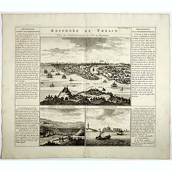
Bosphore de Thrace.
This handsome folio sheet present three views of the strategically important Bosporus. At top is a large decorative bird's-eye view of Istanbul as viewed from across the ...
Place & Date: Amsterdam, 1720
Garde du corps de sa Hautesse. . .
Beautiful engraving by Henri Bonnart (1642?-1711) vis-à-vis les Mathurins au Coq. Printed with the privilege of the King.
- $150 / ≈ €140
Place & Date: Paris, c. 1690
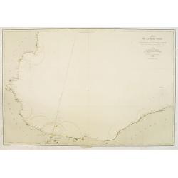
Carte de la Mer Noire. (5e Feuille). Du Cap Zefiros au Cap Kerempeh. . .
Very detailed chart of the Turkish part of the Black Sea including the towns of Sinop, Samsun, etc. Showing soundings in meters, lighthouses are marked with yellow and re...
- $200 / ≈ €187
Place & Date: Paris, 1860

Anamu Buru to Latakia including Iskenderun Körfezi.
A highly corrected version of Admiralty chart 2632 originally published 25 November 1955 under the Superintendence of Captain K.SB. Collins. Edition Date 1984 Detailed ch...
- $100 / ≈ €94
Place & Date: London, 1955 - 1984

Bataille de Zenta, Donnée le 11 de Septembre 1697.
Decorative etching of the siege by Prince Eugène de Savoie of Zenta in Serbia by the French on 11 September 1697. The town, river Tisza and the Ottoman troupes are shown...
Place & Date: Amsterdam, ca. 1700
Selling price: $200
Sold in 2010

Ibraim Pascia Visiragha di Giannizzari. (Portrait of Ibrahim Pasha)
Fine, decorative and very scarce copper engraved portrait of Ibrahim Pasha, Pargali Ibrahim Pasha (1493 or 1494–1536), also known as Frenk Ibrahim Pasha (the "West...
Place & Date: Vienna, Gio. Battista Hacque, 1670
Selling price: $95
Sold in 2010
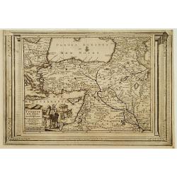
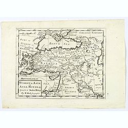
La Turquie en Asie.
Uncommon miniature map of Turkey, Cyprus, Palestine, Iran, Iraq. From Pierre Duval's "La Geographie Universeille" dated 1676. Following his "Cartes de geog...
- $100 / ≈ €94
Place & Date: Paris,1676
Modern Asia Minor. Drawn & Engraved for Dr. Playfair's Geography.
Detailed map of Black Sea, Cyprus and Turkey engraved by Samuel John Neele (1758-1824) and published by Alexander Macredie. Originally engraved for James Playfair's "...
- $175 / ≈ €164
Place & Date: London / Edinburgh, 1824
Ladimistri nel arcipelago. (Edremit)
Magnificent bird's eye-town-view of Edremit on the west coast of Turkey, not far from the Greek island Lesbos. It is situated at the tip of the gulf with the same name (G...
- $150 / ≈ €140
Place & Date: Antwerp, c.1690
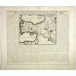
Carte De L'Asie Inferieure Selon Les Auteurs Anciens, Enrichie de Remarques Historiques sur les Changemens qui y sont arrivez.
Text page with inset map (220x269.mm.) of Turkey, including Cyprus from Chatelain's monumental 7 volume "Atlas Historique". Henri Abraham Chatelain (1684 – 17...
- $200 / ≈ €187
Place & Date: Amsterdam, 1720
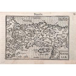
Natolia.
A miniature map of the Arabian peninsula, including Cyprus. The title cartouche on the lower right corner.First published in 1598 in his Caert-Thresoor, the plates were e...
- $200 / ≈ €187
Place & Date: Amsterdam / Frankfurt, 1609
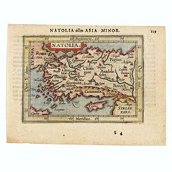
Natolia olim Asia Minor.
Genuine antique map "Natolia" by Abraham Ortelius from Epitome Theatri Orbis Terrarum, published in Antwerp in 1609. This charming 400-year-old miniature copper...
- $200 / ≈ €187
Place & Date: Antwerp, 1609
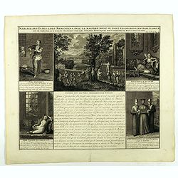
Mariage des Turcs & des Armeniens, avec la ma niere dont se font les demonstrations d'amour . . .
Showing the marriage rituals and lives of Turks and Armenians. Five engravings set round a text panel in French. From Chatelain's monumental 7 volume "Atlas Historiq...
- $150 / ≈ €140
Place & Date: Amsterdam, 1720

Tschanibei Ally Bassa. Türckischer Gross-Böthschafter um Kayserl.
Engraving by Johann Martin Bernigeroth (1713-1767) showing a full portrait of the Turkish ambassador in Vienna Ally Bassa.
Place & Date: Leipzig, c. 1750
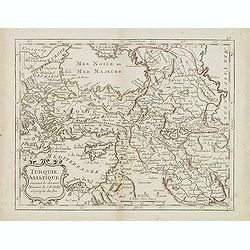
Turquie Asiatique. . .
Scarce map of Turkey prepared by Nolin and published by L.J. Mondhare for his Atlas Général a l'usage des colleges et maisons d'education.. Louis Joseph Mondhare was ac...
- $100 / ≈ €94
Place & Date: Paris, 1783
La Turquie en Asie.
Uncommon miniature map of Turkey, Cyprus, Palestine, Armenia, Iran and Iraq. From Pierre Duval's La Geographie Universeille dated 1676. Following his Cartes de geographie...
- $90 / ≈ €84
Place & Date: Paris, 1676
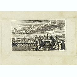
Adrianopel. (Edirne)
Panoramic view of Adrianopel or its modern name Edirne in European Turkey, near the border with Greece and Bulgaria. Published in "Der Donau-Strand Mit allen seinen ...
- $75 / ≈ €70
Place & Date: Nuremberg, Jacob Sandrart, 1684
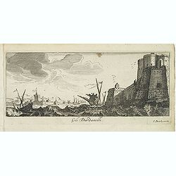
Gli Dardanelli.
Magnificent bird's eye- of Dardanelle street at the Aegean Sea. Etched by Gaspar Bouttats (1640-1695).The Antwerp based publisher Jacques Peeters published ca. 1690 a ser...
- $150 / ≈ €140
Place & Date: Antwerp, c.1690
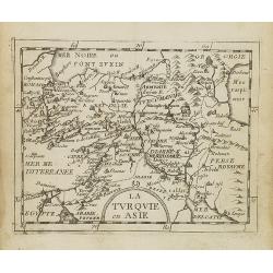
Turquie Asiatique. Par le Sr. Robert Geog. Ord du Roi avec Privilege 1748.
Small detailed map of Turkey. From Atlas Portatif Universel, by Robert de Vaugondy.Page 161 outside border top right. First and only state.
- $80 / ≈ €75
Place & Date: Paris, 1754
Religieux Turc. (26)
Sought-after copper engraved plate taken from Laonikos Chalcocondyle’s "L'histoire de la décadence de l'empire grec et establissement de celuy des Turcs." by...
Place & Date: Paris, Mathieu Guillemot, 1650