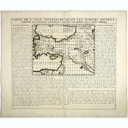
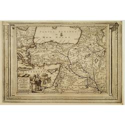
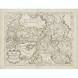
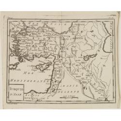
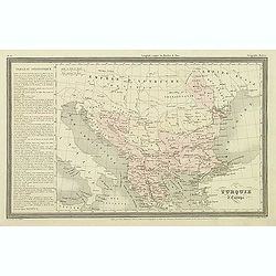
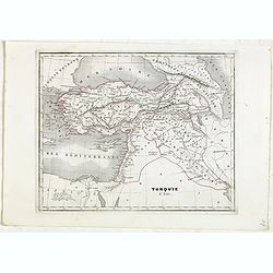
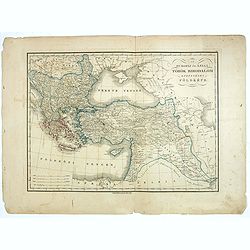
Carte De L'Asie Inferieure Selon Les Auteurs Anciens, Enrichie de Remarques Historiques sur les Changemens qui y sont arrivez.
Text page with inset map (220x269.mm.) of Turkey, including Cyprus from Chatelain's monumental 7 volume "Atlas Historique". Henri Abraham Chatelain (1684 – 17...
Date: Amsterdam, 1720
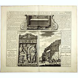
Antiquez curieuses qui se trouvent aux environs de Smyrne, et sur le chemin d'Ephese.
Folio sheet describing and depicting ancient Greek monuments and ruins in Smyrna (Izmir). From Chatelain's monumental 7 volume "Atlas Historique". Henri Abraham...
Date: Amsterdam, 1720
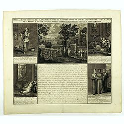
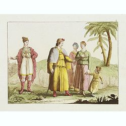
Mariage des Turcs & des Armeniens, avec la ma niere dont se font les demonstrations d'amour . . .
Showing the marriage rituals and lives of Turks and Armenians. Five engravings set round a text panel in French. From Chatelain's monumental 7 volume "Atlas Historiq...
- $150 / ≈ €130
Date: Amsterdam, 1720
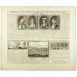
Habillement des femmes de Smyrnes, des Grecques et des Juifs de cette ville.
Four portraits of Smirne women in typical dress, each with a descriptive engraved text. From Chatelain's monumental 7 volume "Atlas Historique".Henri Abraham Ch...
Date: Amsterdam, 1720

Osmann der altiste sohn Achmats der Ersten.
Portrait of Osmann (1605-1622) by Franz Christoph Khevenhiller, from Annales Ferdinandei, oder warhaffte Beschreibung Käysers Ferdinandi des anderen, mildesten Gedächtn...
Date: Leipzig, Weidmann 1721-1726
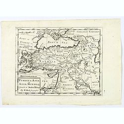
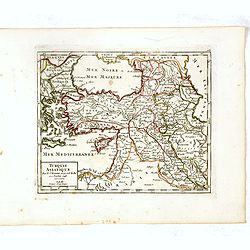
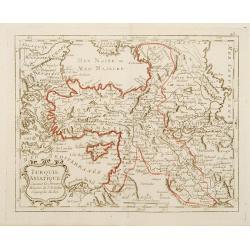
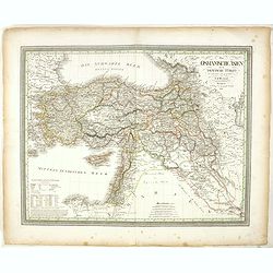
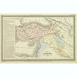
Turquie en Asie, suivant les nouvelles observations..
Uncommon edition of this map of Turkey, Holy Land, Armenia, including Cyprus. With decorative title cartouche lower left corner.This example is unusual in having the addi...
Date: Leiden, 1728
Turkey in Asia: or Asia Minor &c.
Herman Moll's map of the Turkish Empire in Asia, published in London during the first half of the eighteenth century. It shows the eastern Mediterranean, including Crete ...
Date: London, ca 1729
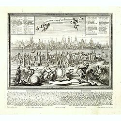
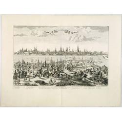
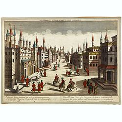
Constantinopolis Constantinopel.
Very rare and decorative panoramic view of Istanbul prepared by Friedrich Berhard Werner and published by Martin Engelbrecht. The engraving is done by Johann Georg Ringli...
Date: Augsburg, M.Engelbrecht, ca.1730-1740
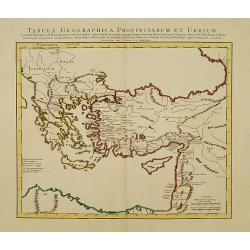
Tabula Geographica Provinciarum et Urbium Colonia Romana. .
Covens and Mortier's Map of the Roman World is a copperplate engraving based on an earlier map by Guillelmo De L'Isle (1675-1726), Geographer to the King of France.Engrav...
Date: Amsterdam c. 1745
Constantinople ville de Romanie et capitale de l'Empire des Turcs.
A very decorative and extremely rare of Istanbul, including a numbered legend in lower part. Published by Jacques Chéreau, (1688 - 1776). Engraved by Aveline and first ...
Date: Paris, ca.1750
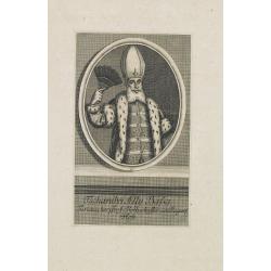
Tschanibei Ally Bassa. Türckischer Gross-Böthschafter um Kayserl.
Engraving by Johann Martin Bernigeroth (1713-1767) showing a full portrait of the Turkish ambassador in Vienna Ally Bassa.
Date: Leipzig, c. 1750
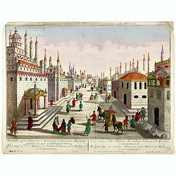
Prospectus, quem Solimanni et Mohameti. . . - Vue aupres de la Mosquee du Sultan Soliman, et de Mohamet . . .
Imaginary view inside Istanbul showing Sultan Soliman in his carriage , a so-called optical print.
Date: Augsburg 1750
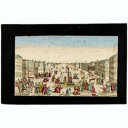
Imaginary view of a square with Muslims festival.
Imaginary view of a square with Muslims festival. A so called optical print.
Date: Paris, ca. 1750
Prospectus septem turrium in urbe Constantinopolitana / Vüe des sept Tours ou Prisons d'etat à Constantinople. . .
Imaginary view inside Istanbul showing the State prison, the seven towers to Constantinople, a so-called optical print.
Date: Augsburg 1750
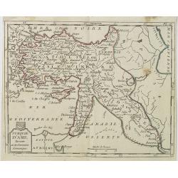
Turquie Asiatique. Par le Sr. Robert Geog. Ord du Roi avec Privilege 1748.
Small detailed map of Turkey. From Atlas Portatif Universel, by Robert de Vaugondy.Page 161 outside border top right. First and only state.
Date: Paris, 1754
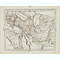
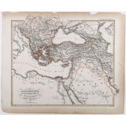
Alexandri magni imperium et expeditio per Africam. . .
Scarce map of the Imperium of Alexander the Great, centered on Turkey, Armenia, Uzbekistan, etc., prepared by Nolin and published by L.J. Mondhare for his Atlas Généra...
Date: Paris, 1781
Turquie Asiatique Suivant des derniers Mémoires de J.B.Nolin Géographe du Roi.
Rare map of Turkey, prepared by J.B.Nolin and published by Monhare for his Atlas Général a l'usage des colleges et maisons d'education.Louis Joseph Mondhare published s...
- $125 / ≈ €108
Date: Paris, 1783
Turquie Asiatique. . .
Scarce map of Turkey prepared by Nolin and published by L.J. Mondhare for his Atlas Général a l'usage des colleges et maisons d'education.. Louis Joseph Mondhare was ac...
- $100 / ≈ €86
Date: Paris, 1783
![[Manuscript] Plan du siege de la forteresse d'Oczakow avec les détails... aux ordres du Prince Potemkin, le 17 Decemb: 1788.](/uploads/cache/34599-250x250.jpg)
[Manuscript] Plan du siege de la forteresse d'Oczakow avec les détails... aux ordres du Prince Potemkin, le 17 Decemb: 1788.
Very detailed well executed manuscript plan of the Turkish Fortress Ochakov captured by Russian Troops on December 17, 1788 by the Maréchal Prince Potemkin. In lower lef...
Date: ca. 1788
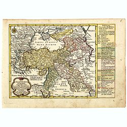
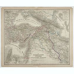
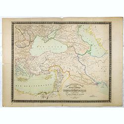
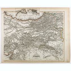
Die Asiatische Turkey begreift in sich Natolien, Georgien, Armenien, Mesopotamien Syrien, und Arabien. . .
Map of Turkey bordered by the Black Sea to the north, Syria and Sinai Peninsula to the south, Turkey in Europe to the west, with a small title cartouche. Explanatory text...
- $200 / ≈ €173
Date: Augsburg, 1789
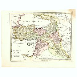
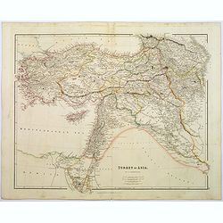
Turkey in Asia.
An attractive map covering Asia Minor, Syria, Armenia, Georgia, Kurdistan, Iraq, Syria, Cyprus and the Black Sea. Shows towns, rivers, mountains, lakes, etc. In pretty or...
- $65 / ≈ €56
Date: London, 1794

Vue du sperbe Temple de St.Sophie .. a Constantinople.
A fanciful depiction of the Aya Sofya in Istanbul. In the eighteenth and nineteenth centuries there were many popular speciality establishments in Paris, Augsburg and Lon...
Date: Paris, 1800
Turquie d'Asie . . .
Map of Turkey, including Cyprus, Palestine, etc. , from Atlas moderne portatif composé de vingt-huit cartes sur toutes les parties du globe terrestre .. A l'usage des Co...
- $100 / ≈ €86
Date: Paris, Prudhomme, Levrault, Debray, 1806
Turquie d'Asie.
Map of Turkey, including Cyprus and part of the Near East. From Atlas de la Géographie de toutes les parties du monde.. Ouvrage destiné pour l'education, et nécessaire...
Date: Paris, Prudhomme, Levrault, Debray, 1806
![Femme de la Carie [together with] Pretre Indous.](/uploads/cache/36926-250x250.jpg)
Femme de la Carie [together with] Pretre Indous.
Set of two originally hand-colored mezzotints of a woman from the region of Bodrum in Turkey and an Hindu Priest engraved by Félix Mixelle and Lachaussée Jeune after Ja...
- $50 / ≈ €43
Date: Paris,1801-1806
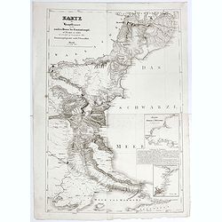
Karte der Hauptstraßen von der niederen Donau bis Constantinopel … / Spezialkarte des Meerbusens von Burgas . ..
Uncommon map of the routes of the eastern part of the Balkan Peninsula. prepared by C. Zirbeck The map has two insets "Meerbusen von Burgas oder Mesambri" (Bay ...
- $550 / ≈ €475
Date: 1820
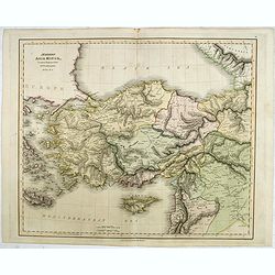
Modern Asia Minor. Drawn & Engraved for Dr. Playfair's Geography.
Detailed map of Black Sea, Cyprus and Turkey engraved by Samuel John Neele (1758-1824) and published by Alexander Macredie. Originally engraved for James Playfair's "...
- $175 / ≈ €151
Date: London / Edinburgh, 1824
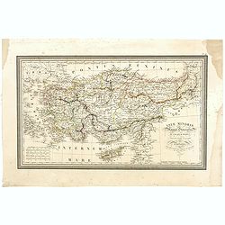
Asiae Minoris Stappa generalis ad Caesarum tempus.
A lovely steel engraved map of Turkey, Cyprus and Minor Asia. From Louis de Saint-Martin Vivien's Atlas Universel. Engraved by Giraldon-Bovinet.
Date: Paris, 1826
[Gyap, father of the young Teschou Lama
Aquatint print with Gyap, father of the young Teschou Lama and his wife and the portrait of the Grand Lama. - Tibet. Plate N° 8. This is from Giulio Ferrario's work Le ...
- $80 / ≈ €69
Date: Milan, 1827
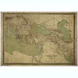
Das Osmanische asien oder die Asiatische Türkey. . .
Decorative map showing 'Asia Minor' with its neighboring countries. Prepared by Karl Ferdinand Weiland The eastern part of the Mediterranean Sea with Cyprus is as well sh...
- $200 / ≈ €173
Date: Weimar, 1836-1838
Die Asiatische Türkei. Die Kaukasusländer und West Persien.
Detailed map of Ottoman Asia or the Asian Turkey. Below the title a colored key to Turkish, Iran, Kurd, Caucasus and Russian possessions.Map prepared by H. Kiepert.
- $75 / ≈ €65
Date: Weimar, 1836-1838
Turkey in Asia.
A lovely looking steel engraved map of Turkey in Asia. Map extent is Asia Minor, Syria, Holy Land, across to the Caucasian peoples that inhabit the lands between the Blac...
Date: London, 1839
Turquie d'Asie.
Finely engraved map of Turkey, Cyprus, Palestine, Kurdistan and Iraq, prepared by A.H.Dufour and engraved by Giraldon-Bovinet. Published by Jules Renouard in his uncommon...
- $50 / ≈ €43
Date: Paris, Jules Renouard, ca.1840
Carte physique et politique de la Turquie d'Europe et d'Asie contenant la Syrie, une partie de l'Egypte . . .
A detailed map including Turkey, Greece, Black Sea, Holy Land, Georgie, Iran, Iraq, Armenia.
Date: Brussels, 1840
Turquie d'Europe.
Finely engraved map of Greece, Bulgaria, Romania, Albania and the east coast of the Black Sea, prepared by A.H.Dufour and engraved by Giraldon-Bovinet. Published by Jules...
Date: Paris, Jules Renouard, ca.1840
Geognostische Karte des Taurus und seiner Nebenzweige in den Paschaliken Adana und Marasch…
Complete title : "Geognostische Karte des Taurus und seiner Nebenzweige in den Paschaliken Adana und Marasch, nebst dem angrenzenden Theile des Paschalikes von Alepp...
Date: Militärisch - geographischen Institute zu Wien, 1842
Turquie d'Asie.
Detailed map of Asian Turkey with Cyprus, prepared by Charles V. Monin (fl.1830-1880) a French cartographer of Caen and Paris. Published in Atlas Universel de Géographie...
- $45 / ≈ €39
Date: Paris, 1845
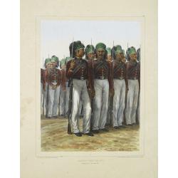
Infanterie Turque (chasseurs). 7 novembre 1837.
Beautiful lithography by Auguste Raffet (1804 -1860 ) and printed by Auguste Bry.
Date: Paris, Gihaut frères, 1848

Plan de Constantinople, non compris ses faubourgs. Grave d'apres les documents du ministere de la Guerre par E. Olivier.
A very rare lithographic large-scale town-plan of Istanbul, Scale 98 yards to one inch., printed in Pera, Istanbul by E. Olivier. The ornate design on the top of the...
Date: Péra, Istanbul, 1851
Die Asiatische Turkey 1854.
Steel engraved map, hand colored in outline when it was published. The detailed map shows the Asian part of Turkey, most of Syria, Iraq, Cyprus and the southern reaches o...
- $70 / ≈ €61
Date: Hildburghausen, Bibliograph Institut,1854
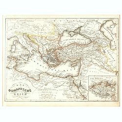
Das Osmanische Reich 1854.
From Meyer's Neuester Zeitungs Atlas. The map is well engraved in the German style with plenty of detail but minimal decoration. Inset map of the Nile Delta.
- $40 / ≈ €35
Date: Heidelberg, 1854
Das osmannische Reich und dessen Schutz-Staaten, nach seiner grossten Ausdehnung im XVIIten Jahrhundert.
Karl von Spruner's historical map of the Ottoman empire at the end of the 17th century. Showing Bosnia to Egypt and as far east as Persia. Including northern part of the ...
- $175 / ≈ €151
Date: Gotha, J.Perthes, ca. 1854
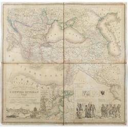
Carte du theatre de la guerre L'Empire Ottoman ..
Very detailed and decorative map of the Ottoman Empire. Lower left a fine panoramic inset (185x80mm) with a view of Istanbul. Next to it a inset map of the Baltic Sea and...
Date: Rouen/ Paris, 1854
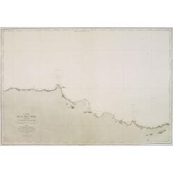
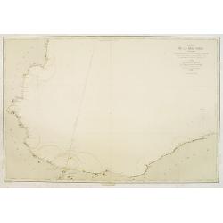
Carte de la Mer Noire. (5e Feuille). Du Cap Zefiros au Cap Kerempeh. . .
Very detailed chart of the Turkish part of the Black Sea including the towns of Sinop, Samsun, etc. Showing soundings in meters, lighthouses are marked with yellow and re...
Date: Paris, 1860

(Untitled view from Scutari with a view of Constantinople)
Panoramic view from Scutari with a view of Constantinople in the distance, after a design by Johann Schranz. Published by J. Missiriè.
Date: Paris, 1860
Specialkarte der Asiatischen Turkey : 1. Blatt Anadoli (Klein - Asien)
Steel engraved map of western part of Turkey, engraved by Ifslieb and J. Grassl.
- $75 / ≈ €65
Date: Hildburghausen, 1860
Az Europai és Asiai Torok Birodalom Kozonséges Foldképe
Hungarian map of Turkey, including Greece, Cyprus, etc.
- $150 / ≈ €130
Date: Pesten, 1864

Carte générale de L'Empire Ottoman en Europe et en Asie dressée par Henri Kiepert . . .
Large School wall map of Turkish Empire printed in chromo-lithography. Published by Dieter Reimer and printed by Ferdind Barth in Berlin. This rare map has two insets in ...
Date: Berlin, Verlag von Dietrich Reimer, 1867
Carte général de L'Empire Ottoman en Europe et en Asie. . . dressée par Henri Kiepert.
Large School wall map of Turkish Empire printed in chromo-lithography. Published by Dieter Reimer and printed by Ferdind Barth in Berlin.This rare map has two insets in l...
- $700 / ≈ €605
Date: Berlin, Dieter Reimer, 1867
Carte de la Mer Noire. (1e Feuille). Du Bosphore à Mangalia et du Bosphore au Cap Kerempeh.
Very detailed chart of the Turkish part of the Black Sea including the towns of Constantinople (Istanbul) , Bourgas. Showing soundings in meters, lighthouses are marked w...
Date: Paris, 1860, updated for 1870
![Veduta di Istambul. [Gouache]](/uploads/cache/45368-250x250.jpg)
Veduta di Istambul. [Gouache]
Very decorative view depicting Istanbul, in the style of Neapolitan gouaches. Features different Mosques and the shores of the Bosporus. Many ships, small and large, are ...
Date: Italy ?, ca. 1870
![[Constantinople]](/uploads/cache/46659-250x250.jpg)
[Constantinople]
The lower half only of a larger map titled 'Turkey Central Mediterranean Regions' by Archibald Fullarton, published in his The Royal Illustrated Atlas of Modern Geography...
Date: London, Edinburgh, 1879
![[Map of Turkey in Ottoman script]](/uploads/cache/40765-250x250.jpg)
[Map of Turkey in Ottoman script]
Map of Turkey, including Cyprus, with text in Ottoman script. In the bottom a color key to the different regions. Published by Elbemühl Graphische Industrie in Vienna (f...
Date: Vienna, ca. 1915

Anamu Buru to Latakia including Iskenderun Körfezi.
A highly corrected version of Admiralty chart 2632 originally published 25 November 1955 under the Superintendence of Captain K.SB. Collins. Edition Date 1984 Detailed ch...
- $100 / ≈ €86
Date: London, 1955 - 1984
