Browse Listings in Asia > Tartary / Siberia
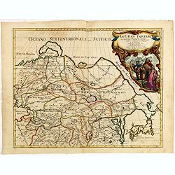
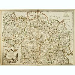
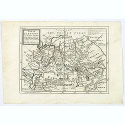
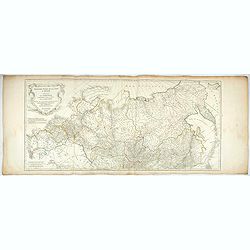
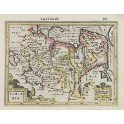
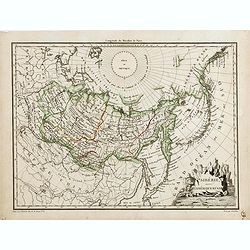
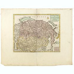
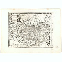
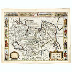
La Gran Tartaria divisa nelle sue parti pricipali da Giacomo Cantelli. . .
In upper right hand corner a large title cartouche with dedication to Tavernier and Thévenot. The cartographer was Giacomo Cantelli (1643-1695) who was active in Modena ...
Place & Date: Rome, 1683
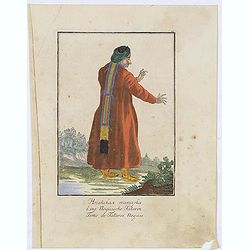
Femme de Tatares Nogais.
Uncommon copper engraved costume plate from the French translation of Johann Gottlieb Georgi "Beschreibung aller Nationen des Russischen Reichs" (1776), the wor...
Place & Date: St. Petersbourg, C.G. Müller, 1776-1777
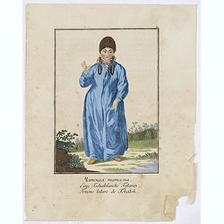
Femme tatares de Tchatsk.
Uncommon copper engraved costume plate from the French translation of Johann Gottlieb Georgi "Beschreibung aller Nationen des Russischen Reichs" (1776), the wor...
Place & Date: St. Petersbourg, C.G. Müller, 1776-1777
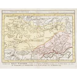
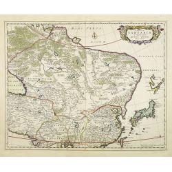
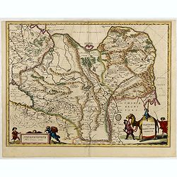
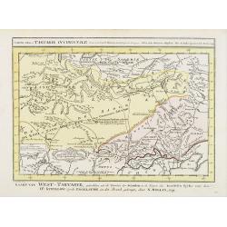
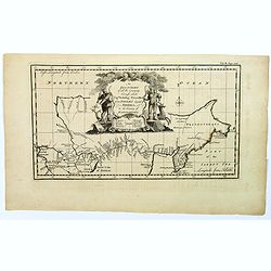
Carte de la Tartarie Occidentale.
Uncommon issue of this finely engraved map showing China's capital city of Peking inland from the Gulf of Lyau-tong. The map locates northeastern China to the border of R...
- $150 / ≈ €140
Place & Date: Amsterdam, 1749
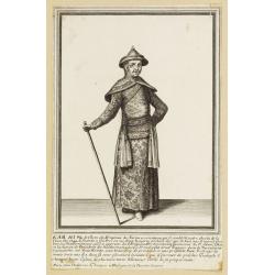
Kam Hi Fils de Chien chi Empereur des Tartares orientaux?.plusieurs titres d'honneur Ecrits de sa propre main.
Very rare and decorative costume plate. Underneath the plate a descriptive text in French. Bears the address AParis Chez Nolin rue St. Jacques à l'Enseigne de la Place d...
- $300 / ≈ €281
Place & Date: Paris ca. 1690
![[Fauna and flora - Siberia].](/uploads/cache/25815-250x250.jpg)
[Fauna and flora - Siberia].
Aquatint depicting a donkey, a weasel and a squirrel, and three botanical plants in Siberia engraved by C.A.Raineri, after drawings by C. Bottigella. Plate N° 22.From Gi...
- $50 / ≈ €47
Place & Date: Milan, 1827
![[Tartares Katschins ].](/uploads/cache/25818-250x250.jpg)
[Tartares Katschins ].
Aquatint depicting people from Tartary engraved by Cantelli, after drawings by C. Bottigella. Plate N° 26.From Giulio Ferrario's work Le Costume Ancien et Moderne ou His...
- $50 / ≈ €47
Place & Date: Milan, 1827
![[Ostiaks ].](/uploads/cache/25822-250x250.jpg)
[Ostiaks ].
Aquatint depicting a Ostiaks people engraved by D.K. Bonatti, after drawings by C. Bottigella.The Ostiak people are a tribe who inhabit the basin of the Ob in western Sib...
- $50 / ≈ €47
Place & Date: Milan, 1827
![[Samoyedes ].](/uploads/cache/25823-250x250.jpg)
[Samoyedes ].
Aquatint depicting Samoyedes warming up around a camp fire engraved by D.K. Bonatti, after drawings by C. Bottigella. The Samoyedes is a tribe of the Ural-Altaic group, s...
- $50 / ≈ €47
Place & Date: Milan, 1827
![[Yakuts ].](/uploads/cache/25825-250x250.jpg)
[Yakuts ].
Aquatint depicting Yakuts in traditional dress engraved by D.K. Bonatti, after drawings by C. Bottigella.The Yakuts live in the Republic of Sakha (YakutiaYakutia), Khabar...
- $75 / ≈ €70
Place & Date: Milan, 1827
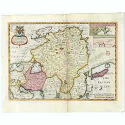
Tabula Tartariae et majoris partis regni Chinae.
Stretching from the Caspian Sea in the west to Formosa in the south-east. Including the peninsula of Korea, Japan, Taiwan and the east coast of Yedso. Decorated with fine...
- $900 / ≈ €842
Place & Date: Amsterdam, 1680
Nieuwe kaart van Tartarie.
A map of Tartary, Korea and part of Japan. The map is most notable for the confusion between Kamchatka and Iesso.Engraved by J.Keyser in 1731.
- $250 / ≈ €234
Place & Date: Amsterdam, 1731 / 1750

Noordoost Cust van Asia van Japan tot Nova Zemla.
An eye-catching chart of Japan, Hokkaido and the Islands to the North of Japan. In the lower left Korea and part of northern China. Korea has three names mentioned: "...
- $2000 / ≈ €1871
Place & Date: Amsterdam, 1666
Tartaria sive Magni Chami imperium.
Detailed and decorative map of Tartary and Northern part of China. Northern tip of Korea included. The Chinese Great Wall is depicted, with Central Asia, extending from M...
- $500 / ≈ €468
Place & Date: Amsterdam, 1638
Carte de Tartarie..
Uncommon Amsterdam edition covering north east Asia, Korea and part of "Terre d'Eso". Nova Zembla joined with the mainland.
- $500 / ≈ €468
Place & Date: Amsterdam, 1706
Carte de Tartarie.
Rare first edition "Chez l'Auteur Rue des Canettes préz de St. Sulpice". The "Rue des Canettes" address appears on the original versions of maps date...
- $600 / ≈ €561
Place & Date: Paris, 1706
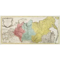
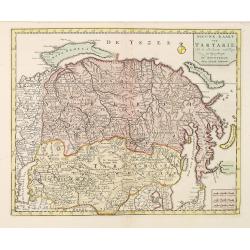
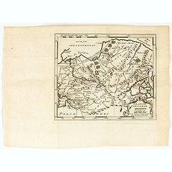
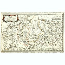
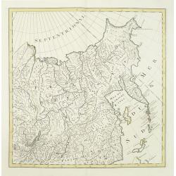
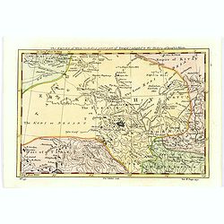
Carte géographique contenant le Royaume de Siberie . . .
Very rare and highly detailed map of Siberia subdivided in three provinces, namely Tobolsk, Jenissejesk, Irkutsk, and outer parts of the Tartary. In upper right corner in...
- $800 / ≈ €749
Place & Date: Augsburg, 1770- 1780
![Une Chamane ou devineresse de Krasnojarsk par derrière.[together with] Une Chamane ou devineresse de Krasnojarsk.](/uploads/cache/33007-250x250.jpg)
Une Chamane ou devineresse de Krasnojarsk par derrière.[together with] Une Chamane ou devineresse de Krasnojarsk.
Uncommon copper engraved costume plate from Johann Gottlieb Georgi "Beschreibung aller Nationen des russischen Reichs" (1776), the work stands out for the hand-...
- $100 / ≈ €94
Place & Date: St. Petersbourg, C.G. Müller, 1776-1780
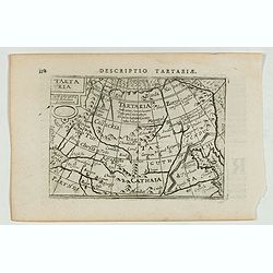
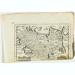
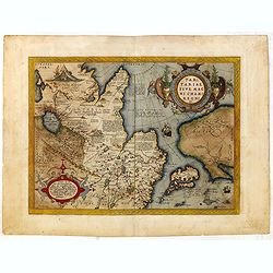
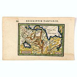
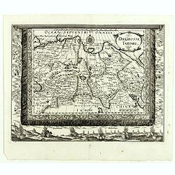
Descriptio Tartariae / Tartaria.
A rare miniature map of Tartary and China, showing the Great Wall. Title cartouche on the upper left corner.First published in 1598 in his Caert-Thresoor, the plates were...
- $300 / ≈ €281
Place & Date: Amsterdam, Cornelis Claes, 1606
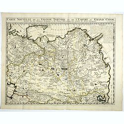
Carte Nouvelle de la Grande Tartarie ou de l'Empire du du Grand Cham. . .
Very detailed map of Northern China, Korea, Russia in the north the Murmansk Sea. Including the western coast of Nova Zembla. Zacharie Chatelain (d.1723) was the father o...
- $250 / ≈ €234
Place & Date: Amsterdam, 1728
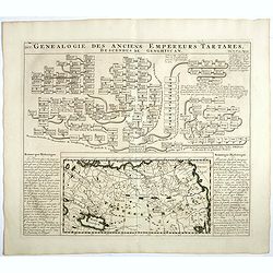
Genealogie des anciens empereurs Tartares,. . .
In lower part a map Russia including Tartary and Korea (158 x 290mm.), flanked by text in French. In top a family tree of the descendants of Genghis Khan.From Chatelain's...
- $75 / ≈ €70
Place & Date: Amsterdam, 1719
Tartariae sive Magni Chami Imperium.
Fine map of Tartary, including northern part of China, and tip of Korea.
- $500 / ≈ €468
Place & Date: Amsterdam, 1645
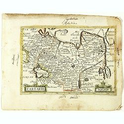
Tartarie.
Rare map of Tartary published by Jollain in 1667. In lower right corner Korea as a peninsular and part of America in upper right corner. Published in "Trésor Des Ca...
- $150 / ≈ €140
Place & Date: Paris, 1667
Great Tartary, with the tract of the Moscovite Ambassador's Travels from Moscow to Pekin in China.
An interesting map illustrating the route taken by the Russian Ambassador on his travels east to Beijing. Shows the Great Wall, "Somer Houses" and "parts u...
- $125 / ≈ €117
Place & Date: London, 1732
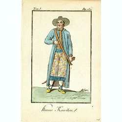
Homme Kouritien.
Originally hand-colored mezzotint of Siberian man dressed in native garb engraved by Félix Mixelle and Lachaussée Jeune after Jacques Grasset de Saint-Sauveur.As an etc...
- $25 / ≈ €23
Place & Date: Paris,1801-1806
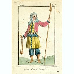
Homme Tschoukotske.
Originally hand-colored mezzotint of a man from Tschukotka, Syberia engraved by Félix Mixelle and Lachaussée Jeune after Jacques Grasset de Saint-Sauveur.As an etcher, ...
- $25 / ≈ €23
Place & Date: Paris,1801-1806
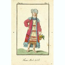
Femme Kamls chadalle.
Originally hand-colored mezzotint of native woman from Kams, Siberia, Russland engraved by Félix Mixelle and Lachaussée Jeune after Jacques Grasset de Saint-Sauveur.As ...
- $50 / ≈ €47
Place & Date: Paris,1801-1806
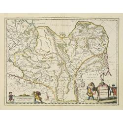
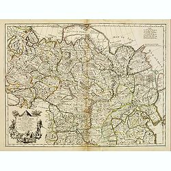
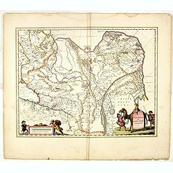
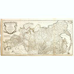
Troisième partie de la carte d'Asie, contenant la Sibérie, et quelques autres parties de la Tartarie. . .
Engraved map of Tartary on two sheets, with country boundaries in out line color. Includes geographic notes and ornamental cartouche by "H. Gravelot, invenit., DeLaf...
- $450 / ≈ €421
Place & Date: Paris, 1753
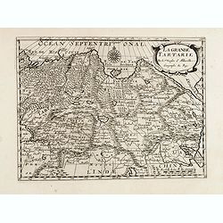
Grande Tartarie.
A very nice map of Tartaria extending from the Caspian Sea to the Pacific Ocean. From Francisco Giustiniani for El Atlas abreviado o el nuevo compendio de la Geografia un...
- $150 / ≈ €140
Place & Date: Leon de Francia (Lyon), Jaime Certa, 1739
Karte von den N.W. Amerikanischen und N.OE. Asiatischen Kusten nach den Untersuchungen des Kapit. Cook...
A detailed large-scale map showing the Bering Strait, Kamchatka, Alaska and much of North America. While the Russian coastline is shown with reasonable accuracy. Showin...
- $450 / ≈ €421
Place & Date: Vienna, 1788
Grande Tartarie et Isles du Japon Suivant les rélations les plus authentiques. . .
Attractive map of Russia, northern Asia, China, Tibet, Turkistan, and Japan, with decorative rococo-style cartouche.Flanked by two columns of French text containing geogr...
- $150 / ≈ €140
Place & Date: Paris, 1790
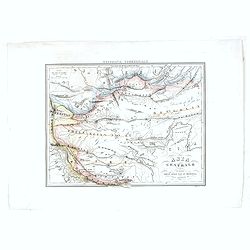
Carte de la Tartarie Occidentale.
Uncommon issue of this finely engraved map shows China's capital city of Peking, inland from the Gulf of Lyau-tong.The map locates in northeastern China to the border of ...
- $100 / ≈ €94
Place & Date: Amsterdam, 1749
Tartaria.
Very fine and decorative engraving showing China, Korea and the northern Pacific coast of America.The two continents are separated by the Straits of Anian. From the first...
- $100 / ≈ €94
Place & Date: Amsterdam, 1608
![Fille Jakoute par derrière [together with] Fille Jakoute par devant.](/uploads/cache/32984-250x250.jpg)
Fille Jakoute par derrière [together with] Fille Jakoute par devant.
Uncommon copper-engraved costume plate from Johann Gottlieb Georgi "Beschreibung aller Nationen des russischen Reichs" (1776), the work stands out for the hand-...
- $75 / ≈ €70
Place & Date: St. Petersbourg, C.G. Müller, 1776-1780
![Fille Jakoute par derrière [together with] Fille Jakoute par devant.](/uploads/cache/32985-250x250.jpg)
Fille Jakoute par derrière [together with] Fille Jakoute par devant.
Uncommon copper-engraved costume plate from Johann Gottlieb Georgi "Beschreibung aller Nationen des russischen Reichs" (1776), the work stands out for the hand-...
- $75 / ≈ €70
Place & Date: St. Petersbourg, C.G. Müller, 1776-1780
![Un Jacout en habit de chasse par devant [together with] Un Jakout en habit de chasse par derriére.](/uploads/cache/32986-250x250.jpg)
Un Jacout en habit de chasse par devant [together with] Un Jakout en habit de chasse par derriére.
Uncommon copper-engraved costume plate from Johann Gottlieb Georgi "Beschreibung aller Nationen des russischen Reichs" (1776), the work stands out for the hand-...
- $75 / ≈ €70
Place & Date: St. Petersbourg, C.G. Müller, 1776-1780
![Fille tatare à Kousnetsk par devant. [together with] Fille tatare Kousnetsk par derriere.](/uploads/cache/32988-250x250.jpg)
Fille tatare à Kousnetsk par devant. [together with] Fille tatare Kousnetsk par derriere.
Uncommon copper-engraved costume plate from Johann Gottlieb Georgi "Beschreibung aller Nationen des russischen Reichs" (1776), the work stands out for the hand-...
- $75 / ≈ €70
Place & Date: St. Petersbourg, C.G. Müller, 1776-1780
![Femme tatare à Kousnetsk par devant. [together with] Femme tatare à Kousnetsk par derriere.](/uploads/cache/32990-250x250.jpg)
Femme tatare à Kousnetsk par devant. [together with] Femme tatare à Kousnetsk par derriere.
Uncommon copper-engraved costume plate from Johann Gottlieb Georgi "Beschreibung aller Nationen des russischen Reichs" (1776), the work stands out for the hand-...
- $75 / ≈ €70
Place & Date: St. Petersbourg, C.G. Müller, 1776-1780
![Une Kirguisiene par devant. [together with] Une Kirguisienne par derriere.](/uploads/cache/32991-250x250.jpg)
Une Kirguisiene par devant. [together with] Une Kirguisienne par derriere.
Uncommon copper-engraved costume plate showing two natives of Kyrgyzstan, a Central Asian country along the Silk Road, the ancient trade route between China and the Medit...
- $75 / ≈ €70
Place & Date: St. Petersbourg, C.G. Müller, 1776-1780
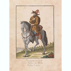
Kirgise à cheval.
Uncommon copper-engraved costume plate from Johann Gottlieb Georgi "Beschreibung aller Nationen des russischen Reichs" (1776), the work stands out for the hand-...
- $50 / ≈ €47
Place & Date: St. Petersbourg, C.G. Müller, 1776-1780
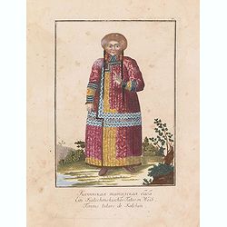
Femme tatare de Katchin.
Uncommon copper-engraved costume plate from Johann Gottlieb Georgi "Beschreibung aller Nationen des russischen Reichs" (1776), the work stands out for the hand-...
- $50 / ≈ €47
Place & Date: St. Petersbourg, C.G. Müller, 1776-1780
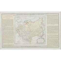
Sibérie avec l'Amérique Russe.
Prepared by Pierre Lapie and published by François Buisson and included in "Atlas Complet Du Precis De La Geographie Universelle De M. Malte-Brun". Engraved by...
- $120 / ≈ €112
Place & Date: Paris, 1812
La grande Tartarie.
Map of Central Asia showing major cities, places and water bodies. Relief shown pictorially. Engraved by Anthony de Winter.
- $150 / ≈ €140
Place & Date: Amsterdam, Utrecht, ca. 1653
Suite de la carte de La Sibérie et le pays de Kamtschatka...
An interesting map of Siberia, with a view on Ochozk Sea. Prepared by Jacques Nicolas Bellin after Dutch sources and included in Prévost d' Exile's "Histoire des Vo...
- $75 / ≈ €70
Place & Date: Paris, 1738-1775
Description de la Tartarie. . .
Detailed map of Tartary, northern China and Korea as an island. The Caspian Sea in the utmost left. Numerous place-names of counties, cities, towns, physical features.Ala...
- $250 / ≈ €234
Place & Date: Paris, 1679
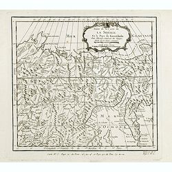
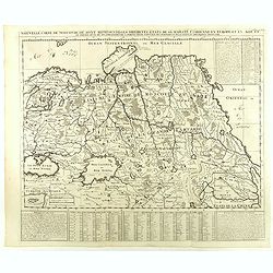
Carte de la sibérie et des Pays voisins.
An interesting detailed map of Siberia, extending from the White Sea and the Caspian Sea in the west to Irkuckoi Province .Prepared by Jacques Nicolas Bellin after Dutch ...
- $50 / ≈ €47
Place & Date: Paris, 1738-1775
Tartaria sive Magni Chami Imperium.
Detailed and decorative map of Tartary and Northern part of China. Northern tip of Korea included. The Chinese Great Wall is depicted, with Central Asia, extending from M...
- $550 / ≈ €515
Place & Date: Amsterdam, 1645
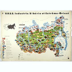
U.R.S.S. Industrie. Sibérie et Extreme-Orient. (4)
Map of Siberia. Propaganda poster for Russia's in and export of industrial goods from Siberia. Editions de l'Agence de presse Novosti".More about War Maps & Prop...
- $150 / ≈ €140
Place & Date: USSR, 1978
A New Map of Great Tartary and China with the adjoining parts of Asia...
Two insets showing the land to the north-east of China according to the Jesuits. Map stretches from northern Russia and Nova Zemlya in the north-west to Formosa in the so...
- $650 / ≈ €608
Place & Date: Oxford, 1700
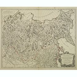
No title (Carte générale de l'empire de Russie).
The right hand sheet of a map of the Empire of Peter the Great.This important map is based on maps from the Bering expedition and on De L'Isle's Akademiia nauk Atlas of 1...
- $800 / ≈ €749
Place & Date: Amsterdam, ca.1748

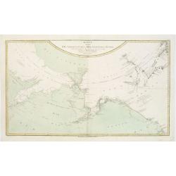
Noordoost Cust van Asia van Japan tot Nova Zembla.
Important for its early depiction of Hokkaido and the Islands to the North of Japan. Ships navigate the seas around the Siberian, Chinese and Japanese coast extending as ...
- $3000 / ≈ €2807
Place & Date: Amsterdam, 1666
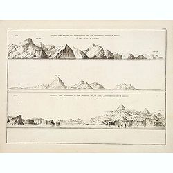
Ansicht der Küste von Kamtschatka vom Cap Poworotnoy Nordlich hinauf - Ansicht der Einfahrt in die Awatscha Bay, in einer entfernung von 4 meilen.
An original view in imperial folio size, originating from the original first edition (Russian & German) of Krusenstern's atlas to his voyage around the world: Atlas k...
- $1500 / ≈ €1404
Place & Date: St.Petersburg, 1824
Nieuwe kaart van Tartarie.
A map of Tartary, Korea and part of Japan. The map is most notable for the confusion between Kamchatka and Iesso. Hokkaido labelled Compagnie LandReflecting the recent di...
- $250 / ≈ €234
Place & Date: Amsterdam, 1750
Tartariae sive Magni Chami Imperium.
This is a very early depiction of the northern Pacific, with the first mapping of Northwest Coast of America and probably the first map to name California 'C. Califormio'...
- $1750 / ≈ €1638
Place & Date: Antwerp, c. 1590
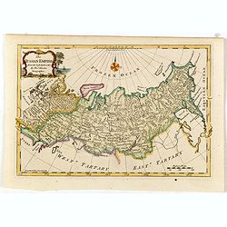
The Russian Empire, from the Best Authorities, by Thos. Kitchin, Geographer.
Showing the Asian part of Russia, with interesting note to a coast line north of Siberia "Land seen in 1723", likely referring to Vitus Bering (1681–1741), wh...
- $150 / ≈ €140
Place & Date: London, c. 1773
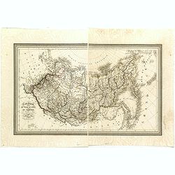
Carte Generale de la Russie d'Asie ou Siberie. Par L. Vivien, Geographe . . .
First edition, with a second edition in 1834 listed by Phillips. The map is well done, slightly smaller than the contemporary Brue and Lapie maps. Showing Asian part of R...
- $230 / ≈ €215
Place & Date: Paris, Ménard et Desenne, 1825
Tartaria.
An original early 17th century copper engraved miniature antique map of Tartary, China and part of America by Petrus Bertius.The title is displayed in a strap work cartou...
- $150 / ≈ €140
Place & Date: Amsterdam, J.Hondius, 1618
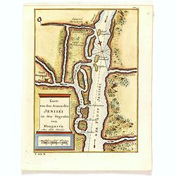
Karte von den Armen des Jeniséi in den Gegenden von Mangaséa Aus dem Gmélin.
Attractive and detailed map of Jenisëi River with the town of Mangasea in Siberia. The composition is nicely balanced with a large title and scale cartouche.
- $75 / ≈ €70
Place & Date: Leipzig, Arkstee & Merkus, 1746
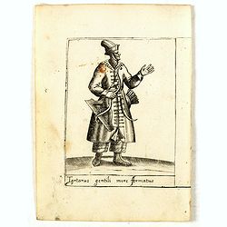
Tartarus gentili more Armatus.
Costume plate published by Pietro Bertelli in his "Diversarum nationum habitus", a sixteenth-century Italian costume book. The work was published with fold-out ...
- $60 / ≈ €56
Place & Date: Padua, 1589
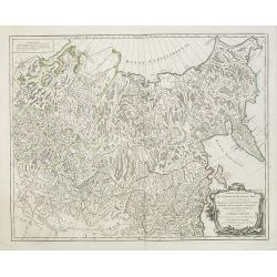
Troisième partie de la carte d'Asie, contenant la Sibérie, et quelques autres parties de la Tartarie. . .
Engraved map of Tartary on two sheets, with country boundaries in out line color. Includes geographic notes and ornamental cartouche by "H. Gravelot, invenit., DeLaf...
- $750 / ≈ €702
Place & Date: Paris, 1754
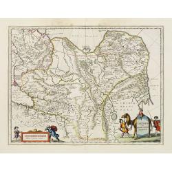
Partie Orientale de l'Empire de Russie en Asie.. et les Confins de la Tatarie Chinoise. . .
Large map with mostly topographical detail of mountains, deserts, rivers and forests. Covers the region from Tomsk eastward and includes Sakhal from his "Atlas Unive...
- $120 / ≈ €112
Place & Date: Paris, 1750
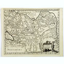
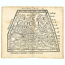
Scythia et Tartaria Asiatica.
A decorative and interesting eighteenth century map of Tartary and Scythia from an atlas first published in Leiden in 1624. Philipp Clüverius (1580–1623) was virtually...
- $125 / ≈ €117
Place & Date: Leiden, 1697
An exact chart of the countries through wich Capt. Behring travelled from Tobolsky capital of Siberia ti the country of Kamtschatka.
The earliest English language map to show Vitus Behring's Route.After retiring from a tour as Captain in the Czar's Navy, Behring, originally from Denmark, settled in Vyb...
- $200 / ≈ €187
Place & Date: London, 1744
The Empire of Hya (including grear part of Tangul)...
Uncommon map of the Gobi Desert.Engraved by Thomas Kitchin - with his signature in lower bottom.From Astley, Thomas, "A New General Collections of Voyages and Travel...
- $100 / ≈ €94
Place & Date: London, 1745-1747
Nouvelle Carte de Moscovie où sont representés les differents etats de sa Maiesté Czarienne. . .
Map of Russia Tartary and part of China with key tables to the towns. Depicting the different states belonging to the Czar in Asia and Europe, showing the path of one of ...
- $250 / ≈ €234
Place & Date: Amsterdam, ca. 1732
Tartarie. (20).
Scarce map of Tartary published by Antoine de Fer in 1661 or 1662 in "Cartes de géographie revues et augmentées". With number 20 in lower right bottom of the ...
- $100 / ≈ €94
Place & Date: Paris, Antoine de Fer, 1657 but 1661 or 1662
Tartaria sive Magni Chami imperium.
Detailed and decorative map of Tartary and Northern part of China. Northern tip of Korea included. The Chinese Great Wall is depicted.
- $120 / ≈ €112
Place & Date: Amsterdam, 1683
Scythia.
Woodblock engraved map covering the region between the Caspian and the Sea of China, much of which is Terra Incognita in the North and East. In 1546 Honter’s Cosmograph...
- $190 / ≈ €178
Place & Date: Zürich, 1546
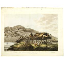
Balagans or summer habitations, with the method of drying fish at St. Peter and Paul, Kamtschatka.
Balagans or summer habitations, with the method of drying fish at St. Peter and Paul, Kamtschatka, taken from "Views in the South Seas" being a very important a...
Place & Date: London, Boydell and Co., 1808
Selling price: $1200
Sold in 2017
Partie Orientale De L'Empire De Russie En Asie, ou trouvent les Provinces de Jakuckskoy, Kransnojarskoy, Selinginskoy, Ilimskoy, Krasnojarskoy, Narimskoy, Jenisseiskoy, Mangajeiskoy, & c. et les Confins de la Tatarie Chinoise. . . .1750
Map of the Northeastern portion of Asia, including Russia, China, the Gobi Desert, etc..
- $250 / ≈ €234
Place & Date: Paris, 1750

Carte des parties Nord et est de l'Asie.. (5 maps on one sheet)
Five maps on one sheet, showing California, Alaska and Syberia, Korea and Japan. South to Korea the island "Quelpaerts".The map is from Diderot's "Encyclop...
- $200 / ≈ €187
Place & Date: Paris, 1772
A newe mape of Tartary.
One of the most decorative maps of Tartary, known for its figured borders with costume figures, while above are vignettes of the cities of Astrakhan, Samarkand and Cambal...
- $2000 / ≈ €1871
Place & Date: London, Bassett & Chiswell, 1627-1676
Asia Centrale, Tibet Thian - Scian - Nan - Lu, Mongolia Grand Deserto &.
From the "Geografia Commerciale". Steel engraving with attractive original outline color, printed on thick paper with wide margins. Engraved by C. Magrini.
- $300 / ≈ €281
Place & Date: Genova, 1860
Carte générale de l'empire des Russes et de la Tatarie Universelle Par le Sr. Robert de Vaugondy fils de Mr. Robert Geog. Ord du Roi avec Privilege 1749.
Small detailed map of Tartary, including China, Corea, Japan and Taiwan. Caspian Sea to the west. From Atlas Portatif Universel, by Robert de Vaugondy.Page 167 outside bo...
- $100 / ≈ €94
Place & Date: Paris, 1749
Die Grosse Tartari.
Rare map showing Siberia, Korea with part of the Caspian Sea to the West, as well as India and North Russia. The title in an oval cartouche in upper right cornerThe map r...
- $1000 / ≈ €936
Place & Date: Augsburg, 1689
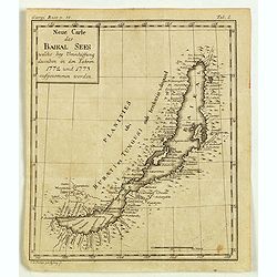
Neue Carte des Baikal Sees welche bey Umschiffung desselben in den Iahren 1773 und 1773 aufgenommen worden.
Rare engraved map by Johanna Dorothea Sysang, showing Lake Baikal. Johanna Dorothea Sysang (1729 - 1791) was a copper engraver from and was a daughter of Johann Christoph...
- $500 / ≈ €468
Place & Date: 1777
![[Tartary - Russia]](/uploads/cache/44310-250x250.jpg)
[Tartary - Russia]
Postcard size map in Ottoman script showing Siberia prepared by Mehmet EŞREF in a small atlas : عمومولاياةىشهانيىحاوىكوچكاطلاس [Umum-i vil...
- $75 / ≈ €70
Place & Date: Istanbul, 1325 or 1909
![КАРТА ТАТАРИ КИТАЙСКОЙ [Map of Tartary in Cyrillic ].](/uploads/cache/44336-250x250.jpg)
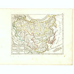
КАРТА ТАТАРИ КИТАЙСКОЙ [Map of Tartary in Cyrillic ].
A rare map of Tartary, including Korea, China and Tibet.This Cyrillic version of the map appeared in one of the first world atlases published in Russia "Novy Atlas, ...
- $750 / ≈ €702
Place & Date: Paris / St.Petersburg, ca. 1790

Tartariae sive Magni Chami Imperium.
This is a very early depiction of the northern Pacific, with the first mapping of Northwest Coast of America and probably the first map to name California 'C. Califormio...
- $2500 / ≈ €2339
Place & Date: Antwerp, c. 1608-1612
Tartaria sive Magni Chami imperium.
Detailed and decorative map of Tartary and Northern part of China, and the Chinese Great Wall is depicted. Including the Caspian Sea and the Volga River east as far as th...
- $575 / ≈ €538
Place & Date: Amsterdam, 1658