Browse Listings in Asia > Philippines
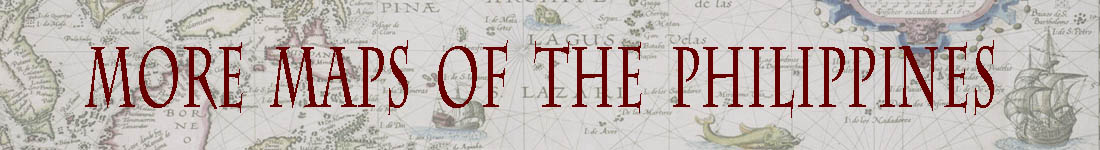
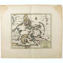
Les Isles Philippines Molucques et de la Sonde.
Sanson's important mid-seventeenth-century map of the East Indies covers modern Indonesia, the Philippines, Malaysia and parts of Southeast Asia and New Guinea. At a scal...
- $1200 / ≈ €1123
Place & Date: Paris, 1654
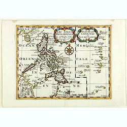
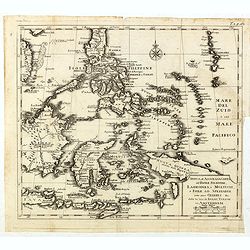
L'india.
This small Italian map of of South East Asia, with Indonesia, , Malacca is based on the cartography of Guillaume Delisle. Japan is shown attached to Ter di Yesso (Hokkai...
Place & Date: Venice, c.1722
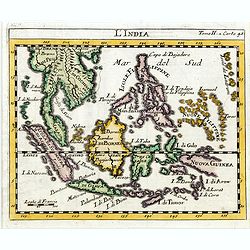
Insulae Palaos seu Novae Philippinae 87 Alias Archipelagus S. Lazari ven Carolinae . . .
Map of Philippine archipelago. Stöcklein's work is a compound of letters of the Jesuit missionaries from all over the world and here particularly the ones stationed at t...
- $1200 / ≈ €1123
Place & Date: Augsburg, 1726
Nieuwe kaart van de Filippynsche, Ladrones, Moluccos of Specery Eilanden als mede Celebes etc.
Shows the western islands of the archipelago, Borneo, Java and Sumatra, up to and including New Guinea. With very good detail to Philippines.Read more Early maps of South...
Place & Date: Amsterdam, 1740
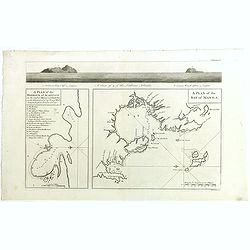
A plan of the Bay of MANILA. A plan of the harbour of Acapulco. A view of 2 of the Ladrone Islands.
The maps show two of the principal harbors of the Manila Galleon Trade, along with a profile view of the Ladrone Islands.In lower right corner "A plan of the Bay of ...
- $450 / ≈ €421
Place & Date: London, Paul Knapton, 1748
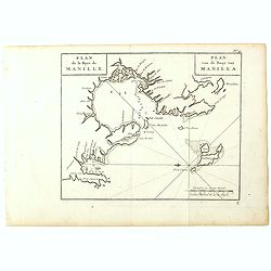
Plan de la Baye de Manille. / Plan van de Baay van Manilla.
Detailed plan of Manila Bay after George Anson's key plan of the Bay of Manila. With a compass rose and soundings in the Bay. East to the top.This is the rare Dutch editi...
- $350 / ≈ €328
Place & Date: Amsterdam, Arkstee and Merkus, 1751
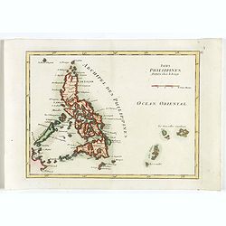
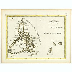
Isles Philippines.
Fine map of the Philippines. George Louis Le Rouge was active from 1740- till 1780 as a publisher, and was appointed engineer for the King of France. From his Atlas Nouve...
- $600 / ≈ €561
Place & Date: Paris, 1756
Isles Philippines.
Fine map of the Philippines. George Louis Le Rouge was active from 1740- till 1780 as a publisher, and was appointed engineer for the King of France. From his Atlas Nouve...
- $750 / ≈ €702
Place & Date: Paris, 1756
Nuova et Accurata Carta dell' Isole Filippine, Ladrones, a Moluccos o Isole della Speziarie come anco Celebes &c.
The map has been prepared by Isaac Tirion for his Nieuwe en beknopte Handatlas (New and concise hand-atlas) of which Albrizzi made an imitation and used in the Italian ed...
- $400 / ≈ €374
Place & Date: Venice, 1740-1762
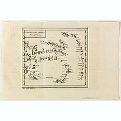
Karte von den neuen philippinen.
Small map of the southern Philippines. In: "Allgemeine Historie der Reisen zur Wasser und zu Lande: oder Sammlung aller Reisebeschreibungen.. in Englischen zusammen ...
- $200 / ≈ €187
Place & Date: Leipzig, Arkstee und Merkus, 1764