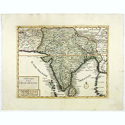
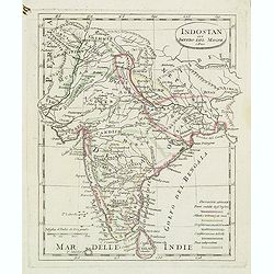
Impero del Gran Mogol.
A very fine map showing India divided into its regions with major towns and cities marked and also parts of its neighbouring kingdoms.
Place & Date: Venice, 1740
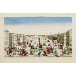
La Feste du Poids au Mogol qui se célebre chez ses Peuples avec grande vénération.
So-called optical print illustrating a perspective view of a square in Mongolia.Mondhare, active at rue St.Jacques a l'Hotel Saumur, was a well-known publisher of optical...
- $230 / ≈ €215
Place & Date: Paris, 1760
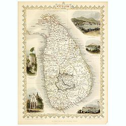
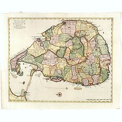
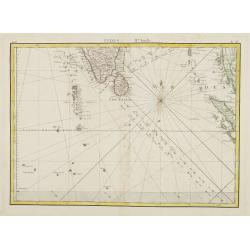
Ceylon.
Decorative steel engraved map of the Ceylon. The Illustrations and engraving by J Rapkin and H.Winckles. The Map was drawn and engraved by John Rapkin.John Tallis a Londo...
- $150 / ≈ €140
Place & Date: London, 1858
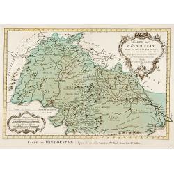
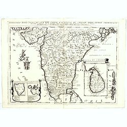
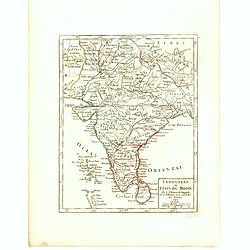
Carte de L'Indoustan. . .
Uncommon edition of this fine map of the northern part of India.From Atlas Portatif pour servir a l'intelligence de l'Histoire Philosophique et Politique des etablissemen...
- $150 / ≈ €140
Place & Date: Amsterdam, 1773
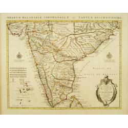
Carte des Côtes de Malabar et de Coromandel Presentée au Roy. . .
Large and attractive map of the Indian coasts of Malabar and Coromandel, embellished with title cartouche and 2 compass roses. It shows the most northern part of Ceylon.T...
- $500 / ≈ €468
Place & Date: Amsterdam c. 1745
![Bay of Bengal, compiled chiefly from government survey.. [2 sheets]](/uploads/cache/23495-250x250.jpg)
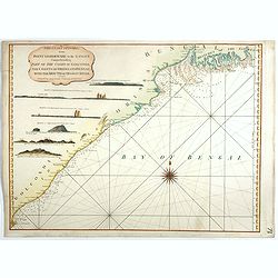
Bay of Bengal, compiled chiefly from government survey.. [2 sheets]
Large scale chart in 2 sheets focused on the Bay of Bengal.It covers Sri Lanka, the whole Indian eastern coast, the seacoast of Bangladesh, Myanmar and Thailand as far as...
- $1200 / ≈ €1123
Place & Date: London (1863), corrections to 1871
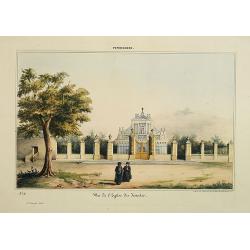
Pondichery - Vue de l'Eglise des Jésuites.
Lithography representing a view of a church belonging to the Jesuit order. Plate N° 11.From Souvenirs d'un voyage dans l'Inde, exécuté de 1834 à 1839, by A. Delessert...
- $300 / ≈ €281
Place & Date: Paris, 1843
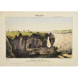
Southern - Concan.. - Nalkind or Kates Point..
Lithography representing a rocky landscape in the Western Ghats. Plate N° 12. From Souvenirs d'un voyage dans l'Inde, exécuté de 1834 à 1839, by A. Delessert.Adolphe ...
- $300 / ≈ €281
Place & Date: Paris, 1843
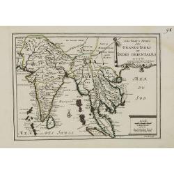
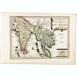
Les Vrays Indes dits Grands Indes ou Indes Orientales Par N. de Fer. Geographe de Sa Majeste Catoliques et de Monseigneur le Dauphin.
Detailed map on India, Thailand, the Malay Peninsular and the south coast of China up to Macao. The map was engraved by C. Inselin.
- $500 / ≈ €468
Place & Date: Paris, 1703
![(2 charts of Shri Lanka) Mer des Indes - Ile de Ceylan - Partie Nord. Détroit de Palk et Golfe de Manaar.. [with] Partrie Sud...](/uploads/cache/23493-250x250.jpg)
(2 charts of Shri Lanka) Mer des Indes - Ile de Ceylan - Partie Nord. Détroit de Palk et Golfe de Manaar.. [with] Partrie Sud...
Two very large charts representing the northern and southern part of Sri Lanka and giving details about the Indian seacoast around the Gulf of Mannar and the Palk Strait....
- $750 / ≈ €702
Place & Date: Paris, 1866
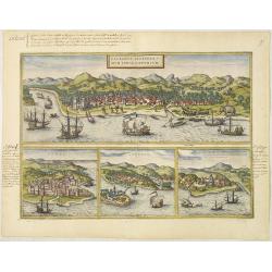
Calechut Celeberri mum Indiae Emporium/ Ormus/ Canonor, St.Georgii.
Four panoramic town-views on one sheet: The upper approximately two-thirds of this double page sheet contains a fine panoramic view of Calicut which is on the west coast ...
- $750 / ≈ €702
Place & Date: Cologne, 1580
Colombo Harbour From Surveys supplied by Sir. John Coode. . .
Sir John Coode's highly detailed map of the Harbour at Colombo (Sri Lanka), with manuscript notations and corrections in pencil. With red pencil "INCORRECT".The...
- $500 / ≈ €468
Place & Date: London, 1885 -1896
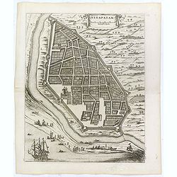
Negapatam.
Bird's-eye view of Nagapattinam or Negapatam, India, printed for the first Dutch edition of Baldaeus' work "A true and exact description of the most celebrated East-...
- $200 / ≈ €187
Place & Date: Amsterdam, 1672
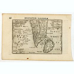
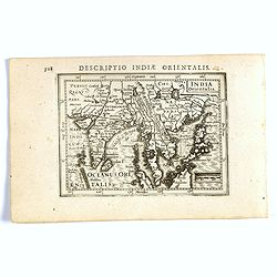
Descriptio Narsingae / Narsinga et Ceylon.
A rare miniature map of the southern part of India with Sri Lanka. The title cartouche on the upper right corner.First published in 1598 in his Caert-Thresoor, the plates...
- $350 / ≈ €328
Place & Date: Amsterdam, Cornelis Claes, 1606
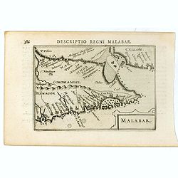
Malabar.
Very fine early miniature map of southern part of India and a part of Ceylon island. Title cartouche on the lower right corner.First published in 1598 in his Caert-Threso...
- $200 / ≈ €187
Place & Date: Amsterdam, Cornelis Claes, 1606
The Coast of India, from Point Gordeware to the Ganges Comprehending Part of the Coast of Golconda . . .
Detailed sea chart of the coast of India, from the mouths of the Ganges Rivers in the northeast to Point Gordeware in the south west. Includes numerous sailing channels a...
- $400 / ≈ €374
Place & Date: London, 1794
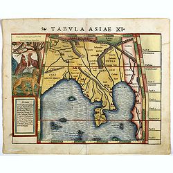
Tabula Asiae XI.
Attractive early woodblock map of the Indian Ocean, extending from Southeast Asia to the Ganges River and north to the Himalayas.In upper left inset panel of tiger, cocke...
- $600 / ≈ €561
Place & Date: Basle, H. Petri, c. 1552
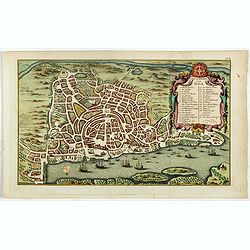
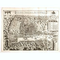
Grundriss von Goa.
A beautifully detailed and engraved town-plan of the Portuguese colony of Goa in India, with a number key (1-29) to the city's major monuments and sites, enclosed in a de...
- $450 / ≈ €421
Place & Date: Amsterdam, 1752
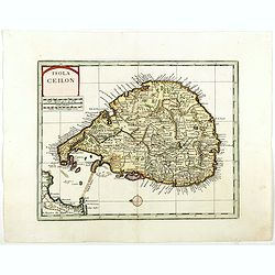
Isola Ceilon.
Attractive copper engraved map of Sri Lanka showing mountains, Towns and the Rama's Bridge (Ponte di Adamo). Included in "Atlante Novissimo che Contiene Tutte le Par...
- $500 / ≈ €468
Place & Date: Venice, 1740
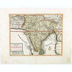
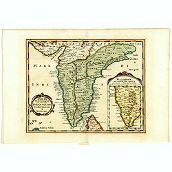
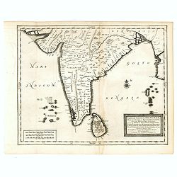
Impero del Gran Mogol.
Attractive copper engraved map of India with Sri Lanka. Showing mountains, towns and the Rama's Bridge (Ponte di Adamo). Included in "Atlante Novissimo che Contiene ...
- $450 / ≈ €421
Place & Date: Venice, 1740
Les Vrays Indes dits Grands Indes ou Indes Orientales Par N. de Fer. Geographe de Sa Majeste Catoliques et de Monseigneur le Dauphin.
Detailed map on India, Thailand, the Malay Peninsular and the south coast of China up to Macao. The map was engraved by C. Inselin.
- $600 / ≈ €561
Place & Date: Paris, 1705
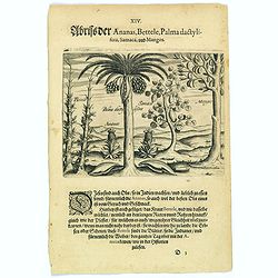
Pineapple, Bettel, palma dactylifera, Samaca & Mango.
These are all Indian fruits, of which the pineapple has the best flavour and aroma. The Bettel plant is also shown here climbing up long rods and canes, just as the peppe...
- $100 / ≈ €94
Place & Date: Frankfurt, 1598
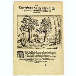
The trees that bear Cayus and Jambos and other plants.
Here are shown two trees that produce good fruits but it is the Jambos that is the best and most beautiful according to written accounts. Also shown is how the Perrer pla...
- $80 / ≈ €75
Place & Date: Frankfurt, 1598
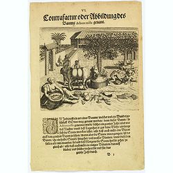
The bamboo, the tree of roots and the Durian fruit.
In India there is a kind of cane, known as Bambus, which has a stem as thick as a human leg. This is used for many things as it is light and yet strong. There is also a k...
- $80 / ≈ €75
Place & Date: Frankfurt, 1598
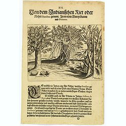
The extraordinary 'Abore Triste' tree of India.
In India there is an extraordinary tree, known as the 'Abore Triste', which is regarded as one of God's miracles. This tree flowers for a whole year but only at night tim...
- $80 / ≈ €75
Place & Date: Frankfurt, 1598
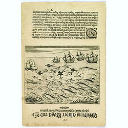
Birds and fish seen during the voyage to India.
During their voyage to India many strange birds were seen, for example, the 'Garayos' that were the size of a chicken, the 'Rabos de Juncos' that are white and about the ...
- $100 / ≈ €94
Place & Date: Frankfurt, 1598
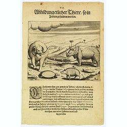
The bird called 'Eeme' and other creatures of India.
Especially on the island of Java and in India, is found a strange bird, called an 'Eeme'. It is almost as large as an ostrich with strong and sturdy legs but it has no to...
- $90 / ≈ €84
Place & Date: Frankfurt, 1598
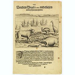
Some of the animals that are found in India.
Although most elephants are found in Ethiopia, there are also many in India too. They are called 'Caffres' by the inhabitants and are slaughtered for their tusks, which t...
- $100 / ≈ €94
Place & Date: Frankfurt, 1598
![[Afghanistan].](/uploads/cache/44611-250x250.jpg)
[Afghanistan].
A scarce Russian relief map (in Russian) of Afghanistan published in Moscow during the Soviet occupation of the country during the early 1980s. Complete with a separate b...
- $250 / ≈ €234
Place & Date: Moscow, 1982
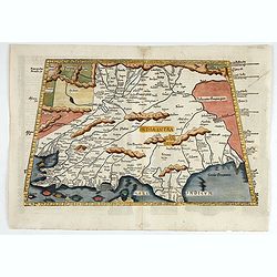
Tabula X. Asiae hae sunt e cognitis totius orbis.
The earliest printed representation of India west of the Ganges River in Ptolemy's time. Considerable detail of river systems and mountain ranges.The first issue of this...
- $1000 / ≈ €936
Place & Date: Lyons, M. Servetus, 1525
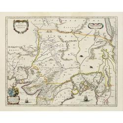
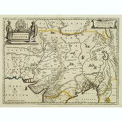
Magni Mogolis Imperium.
An attractive map of the northern part of India, Tibet, Iran to Burma. The travel route from Kabul to Surat is the most prominent feature of the map. Richly decorated wit...
- $650 / ≈ €608
Place & Date: Amsterdam, 1658
Magni Mogolis Imperium.
An attractive map of northern part of India, Tibet, Iran to Burma. The travel route from Kabul to Surat is the most prominent feature of the map. Richly decorated with st...
- $500 / ≈ €468
Place & Date: Amsterdam, after 1638
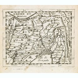
Empire du Mogol.
Uncommon miniature map of the Mongol empire from Pierre Duval's La Geographie Universeille dated 1676. Following his Cartes de geographie in 1657, Pierre Duval published ...
- $150 / ≈ €140
Place & Date: Paris, 1676
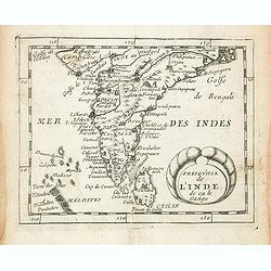
Presqu''isle de L'Inde de ça le Gange.
Uncommon miniature map of India from Pierre Duval's La Geographie Universeille dated 1676. Following his Cartes de geographie in 1657, Pierre Duval published this smaller...
- $150 / ≈ €140
Place & Date: Paris, 1676
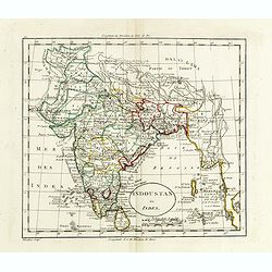
Indoustan ou Inde.
Map of India. The map is based on the Paris Meridian, only in 1884, at the International Meridian Conference in Washington DC, the Greenwich Meridian was accepted.Engrave...
- $100 / ≈ €94
Place & Date: Paris, c. 1810
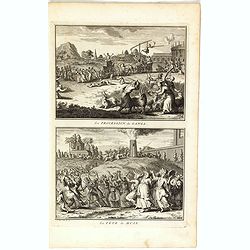
La procession de Ganga/ La fête de Huly.
Two scenes on one page showing religious scenes, in Japan. Fine copper engraving by Bernard Picart and taken from Bernard Picart's famous Céréonies et costumes religieu...
- $30 / ≈ €28
Place & Date: Amsterdam, 1743
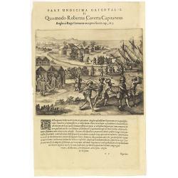
Pars Undecima Orientalis II. Quomodo Robertus, Caverta Capitaneus.
Fine engraving showing the arrest of the English captain Robert Caverta. Below an explanation in Latin that Caverta was arrested and killed by order of the king of the Co...
- $100 / ≈ €94
Place & Date: Frankfurt, 1609
Goa.
A finely engraved, detailed plan of Goa. It also appeared in Gottfried’s Archontologia (1649). There is a cartouche identifying 43 buildings and the plan includes the h...
- $300 / ≈ €281
Place & Date: Frankfurt, 1680
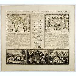
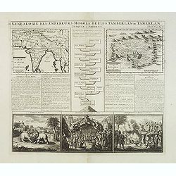
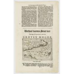
Genealogie des empereurs Mogols . . .
Text sheet with two inset maps of "Carte de l'empire du grand Mogol (122x158mm.) and inset map of Kahsmire "carte nouvelle du royaume de Kachemire" (120x15...
- $150 / ≈ €140
Place & Date: Amsterdam, 1728
India extra Gangem . . .
Map covering the subcontinent from the Bay of Bengal and the Gulf of Cambay to Ceylon (Sri Lanka) and offers impressive detail given that the interior of India was largel...
- $300 / ≈ €281
Place & Date: Utrecht / Amsterdam, J.Halma, 1683
Penisola dell'Indo di qua del Gange, e l isola di Ceilan..
India below the Tropic of Cancer, with an inset of Ceylon and Trincomalee.The remarkable Vincenzo Coronelli (1650-1718), encyclopaedist, geographer, inventor and Doctor o...
- $800 / ≈ €749
Place & Date: Venice, 1698

Carte réduite de l'Océan Oriental, depuis Le Cap de Bonne Espérance jusqu'à l'Isle Formose.
French chart covering the seas between the Cape of Good Hope until Taiwan and the West Coast of Australia. Prepared by Jacques-François L'Abbé Dicquemare (1733-1789). L...
- $1000 / ≈ €936
Place & Date: Paris, Brest, chez Demonville, 1775
![[Mongolian pipe smoking ].](/uploads/cache/26258-250x250.jpg)
[Mongolian pipe smoking ].
Aquatint depicting a group of Mongolians in traditional attire during a pipe smoking ceremony. Chinese and Mongolian tradition had tobacco smoking from pipes with small m...
- $80 / ≈ €75
Place & Date: Milan, 1827
Genealogie des anciens empereurs mogols,. . .
Text sheet with two inset maps of "Carte de l'empire du grand Mogol (122x158mm.) and inset map of Kahsmire "carte nouvelle du royaume de Kachemire" (120x15...
- $150 / ≈ €140
Place & Date: Amsterdam, 1728

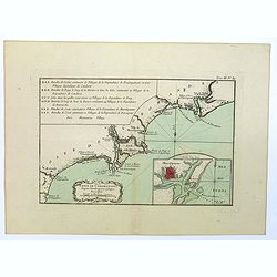
Carte de la Baye et du Port de Trinquemalay dans L'Isle de Ceylan.
Chart showing the bay of Trincomalee, Ceylon (Sri Lanka). Trincomalee is natural deep water port on the east coast of Sri Lanka, about 110 miles northeast of Kandy. It is...
- $450 / ≈ €421
Place & Date: Paris, 1775
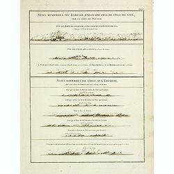
Vues diverses du fort de l'Agouade pres de l'isle de Goa . . . Sumatra . . .
French sea sea chart with 9 coastal views near Goa in India and Sumatra. The titles above the main profiles reading as following : Vues diverses du fort de l'Agouade pre...
- $200 / ≈ €187
Place & Date: Paris, Brest, Demonville, 1775
Nieuwe kaart van het Eyland Ceylon. . .
Fine map depicting the Island of Ceylon/Sri Lanka, oriented with north to the left.. Good interior detail is given with settlements, roads, etc. An attractive early map, ...
- $850 / ≈ €795
Place & Date: Amsterdam, 1726
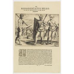
VI. Repraesentatio Bellorum, et Quomodo se ad Illa praeparent. (How the natives fight each other)
This shows how the men go to war and which weapons they use. They hold large square shields, about six feet high and four feet wide, made of cane and fortified with ox-hi...
- $90 / ≈ €84
Place & Date: Frankfurt, 1609

Carte de la Baye et du Port de Trinquemalay Dans L'Isle de Ceylan.
French chart of the harbor of Trinquemalay on the island of Ceylon. Prepared after Samuel Cornish who was a vice admiral for the English East India company.Latitude and l...
- $350 / ≈ €328
Place & Date: Paris, Brest, chez Demonville, 1775
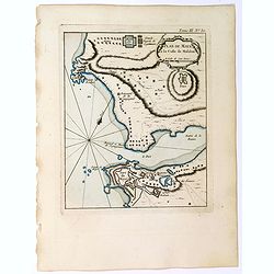
Plan de Maye a la Coste de Malabar.
From Bellin's "Le Petit Atlas Maritime", a plan of the bay of Maye, off the Malabar coast of southern India. Map relief shown pictorially. Shows settlements, po...
- $100 / ≈ €94
Place & Date: Paris, 1764
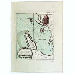
Baye Ville et Forts d'Andarajapour a la Coste de Malabar.
From Bellin's popular "La Petit Atlas Maritime", showing the bay, fort and town of Andarajapour in the Malabar region of India. The map is furnished with a comp...
- $110 / ≈ €103
Place & Date: Paris, 1764
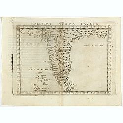
Calecut Nuova Tavola.
Early map of India, extending from west of the Gujarat peninsula eastward to Bengal and south as far as northern Ceylon (“Ceilam”). Girolamo Ruscelli first published ...
- $350 / ≈ €328
Place & Date: Venice, 1564
![Repraesentatio Aedificiorum in Benyn, et Quid Praeterea notatu dignum ibi occurrat. [Execution of criminals in Benin.]](/uploads/cache/29834-250x250.jpg)
Repraesentatio Aedificiorum in Benyn, et Quid Praeterea notatu dignum ibi occurrat. [Execution of criminals in Benin.]
Execution of criminals in Benin. According to the text: The town of Benin is quite large and comprises homes with no windows, only open roofs. The more distinguished hous...
- $100 / ≈ €94
Place & Date: Frankfurt, 1609

Vicariati E prefetture apostoliche nelle Indie Orientalis
Map showing the boundaries of Catholic dioceses in South and Southeast Asia in 1850s, with some detail of India, Malacca, Thailand and Hainan. This finely engraved and be...
- $500 / ≈ €468
Place & Date: Rome, 1858-1859
Presqu Isle de L'Inde. deca la Gange.. .
Two maps together on one sheet. General map showing the southern part of India, including the northern part of Shri Lanka. In an inset a detailed map of the most southern...
- $150 / ≈ €140
Place & Date: Amsterdam, 1700
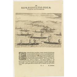
IX. Repraesentatio Piscationum Diurnarum.
Fishing offshore at the coasts of Guinea. Theodore de Bry, a German engraver and book dealer, began a compilation of early voyages in 1590 and had published six parts at ...
- $75 / ≈ €70
Place & Date: Frankfurt, 1609
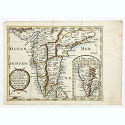
Suite de la Carte des L'Indoustan, Iie Feuille..
Uncommon edition of this fine map of India.From Atlas Portatif pour servir a l'intelligence de l'Histoire Philosophique et Politique des etablissements et du commerce des...
- $200 / ≈ €187
Place & Date: Amsterdam, 1773
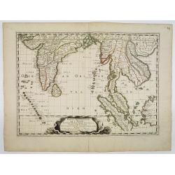
Carte du Golfe de Bengale, Mer de Indes, et Riviere du Gange, Avec les Pais et Iles d'alentour, Savoir les Cotes de Malabar, Cormandel, Ile de Ceylon, Les Maldives . . .
Detailed map of the Southern part of India with Ceylon. Good detail along the coasts of Malabar, Coromandel, the Maldives islands and the Kingdoms of Visipour, Golconda, ...
- $375 / ≈ €351
Place & Date: Leiden, 1719
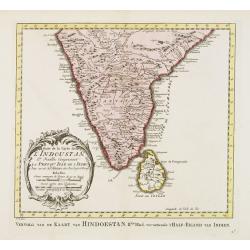
Indoustan ou Etats du Mogol Par le Sr. Robert de Vaugondy fils de Mr. Robert Geog. Ord du Roi avec Privilege 1749.
Small detailed map of India with Ceylon. From Atlas Portatif Universel, by Robert de Vaugondy.Page 188 outside border top right. First and only state.
- $100 / ≈ €94
Place & Date: Paris, 1749
Karte von den Bengaslishen Meerbussen . . .
Manuscript map including Ceylon, south of India, Bengal gulf with Burma (Myanmar), Thailand and northern tip of Sumatra. Very decorative and colorful compass rose in cent...
- $1750 / ≈ €1638
Place & Date: Germany, ca. 1760
India Orientalis.
FIRST IMPRINT FROM THE NEWLY ENGRAVED PLATES IN 1616. - A rare miniature map of the East Indies.First published in 1598 in his Caert-Thresoor, the plates were executed by...
- $400 / ≈ €374
Place & Date: Amsterdam, J. Hondius, 1616
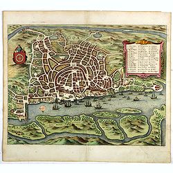
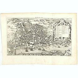
Goa Indiae orientalis metropolis.
A fine example of a rare plan of this important Indian city and port, the focal point for Portuguese trading activity in southern Asia. Pictorial map by Pieter Boudewyn v...
- $600 / ≈ €561
Place & Date: Leiden, 1719
![[No title] Mongol.](/uploads/cache/39729-250x250.jpg)
[No title] Mongol.
Interesting sheet with four detailed engravings illustrating Mongol's life scenes. In upper right margin: 'Tom. V. No 43. Pag: 116.Henri Abraham Chatelain (1684 – 1743)...
- $150 / ≈ €140
Place & Date: Amsterdam, 1728
![[No title] Hindou](/uploads/cache/39730-250x250.jpg)
[No title] Hindou
Interesting sheet with four detailed engravings illustrating Hindou's life scenes. In upper right margin: 'Tom. V. No 42. Pag: 116.Henri Abraham Chatelain (1684 – 1743)...
- $100 / ≈ €94
Place & Date: Amsterdam, 1728
![Calechut Celeberrimum Indiae Emporium [on sheet with] Ormus [and] Canonor [and] S. Georgii Oppidum Mina.](/uploads/cache/41525-250x250.jpg)
Calechut Celeberrimum Indiae Emporium [on sheet with] Ormus [and] Canonor [and] S. Georgii Oppidum Mina.
Four very desirable and early town-plans of Kozhikode, Hormuz, Kannur and Almina. "KOZHIKODE (CALICUT) : "The city is viewed from the sea, just as it would hav...
- $800 / ≈ €749
Place & Date: Cologne, (1572) 1577
Plan de Goa.
A beautifully detailed and engraved town-plan of the Portuguese colony of Goa in India, with a number key (1-29) to the city's major monuments and sites, enclosed in a de...
- $250 / ≈ €234
Place & Date: Paris, 1750
![Plan de Gingy, ville et forteresse d'Asie . . . [An Early Manuscript Map of Pondicherry Prior To Its Reconstruction After The Seven Years War.]](/uploads/cache/43006-250x250.jpg)
Plan de Gingy, ville et forteresse d'Asie . . . [An Early Manuscript Map of Pondicherry Prior To Its Reconstruction After The Seven Years War.]
An early manuscript map of Gingy shortly after The Seven Years War, when the French took possession of large part of India.With an extensive key to the left.Gingee Fort o...
- $1500 / ≈ €1404
Place & Date: Paris, 1765
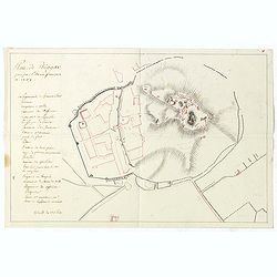
Plan de Thiagar, prise par l'arméé française en 1759.
An early manuscript map of Thiagar. With an extensive unfinished key to the left. The map was drawn shortly after the end of the Seven Years War, when the French took pos...
- $750 / ≈ €702
Place & Date: Paris, 1769
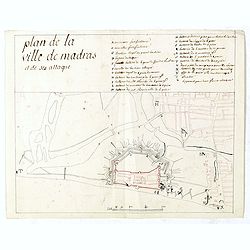
Plan de la ville de Madras et de ses attaques.
Manuscript map, in black, brown and red ink, showing the fortifications of the city of Madras, now Chennai, on the east coast of India, north of Pondicherry.Showing the c...
- $2000 / ≈ €1871
Place & Date: Paris, ca 1760

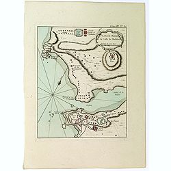
De Zuydwest-Kust van Het Eyland Ceylon.
A finely engraved and detailed chart of Punta Gala harbour.Very rare: only included in 6th volume (so-called secret atlas) of Van Keulen's. A lettered key in upper left c...
- $1000 / ≈ €936
Place & Date: Amsterdam, 1753
![ИНДIИ [Map of India in Cyrillic].](/uploads/cache/44340-250x250.jpg)
ИНДIИ [Map of India in Cyrillic].
A map of India. This Cyrillic version of the map appeared in one of the first world atlases published in Russia, "Novy Atlas, ili sobranie kart ..." which trans...
- $750 / ≈ €702
Place & Date: Paris / St.Petersburg, ca. 1790
Indes. IIe. Feuille.
Attractive map of the southmost tip of India and Sri Lanka, including the Maldives and part of Sumatra. Boundaries are outlined in hand color.From the "Atlas moderne...
- $200 / ≈ €187
Place & Date: Paris ca 1783
Malabar.
Small map illustrating the southwestern sea coast of India. Oriented with East on top, surrounded by text in Dutch.Included in the rare book : Wereld Spiegel, waer in ver...
- $200 / ≈ €187
Place & Date: Amsterdam, Cloppenburch, 1621
Southern - Concan.. - The falls of Gokank..
Hand colored lithography representing a view of the Gokak Falls, located on the Ghataprabha river. Plate N° 14. From Souvenirs d'un voyage dans l'Inde, exécuté de 1834...
- $250 / ≈ €234
Place & Date: Paris, 1843
Partie Meridionale De L'Inde En deux Presqu'Isles l'une deca et l'autre Gange . . . 1654
Sanson's important mid-seventeenth-century map of India and Southeast Asia. At a scale of about 1:9,000,000, it covers most of modern India, Bangladesh and Burma, the who...
- $600 / ≈ €561
Place & Date: Paris, 1654
Indostan gia impero del mogol. . .
Charming map of India with Ceylon from the rare atlas Atlante Tascabile o sia Serie di Num. XXI Cartine Geografiche nelle quali si rappresenta in ristretto lo Stato Attua...
- $150 / ≈ €140
Place & Date: Rome, 1823

Calecuty Regnum
A rare and unusual depiction of the Indian Ocean between Madagascar, Ethiopia, southern Arabia, and south India and Ceylon.The calligraphy is florid and decorative. The e...
- $2000 / ≈ €1871
Place & Date: Cologne, 1596
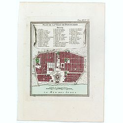
Plan de la ville de Pondicheri.
The first detailed French plan of Pondicherry. In the lower part, a lettered and numbered key and the coat of arms of Mr. Joseph-François Dupleix.The Compagnie des Indes...
- $120 / ≈ €112
Place & Date: Paris, 1800
Coste de Coromandel depuis Gondagamas jusqu'a Narzapour.
This map is taken from Bellin'spopular 'Petit atlas maritime'. It shows a portion of the Indian coastline in the region of Coromandel from Montepdly through Mazulipatam o...
- $110 / ≈ €103
Place & Date: Paris, 1764
Plan de Maye a la Coste de Malabar.
From Bellin's 'Le Petit Atlas Maritime', a plan of the bay of Maye, off the Malabar coast of southern India. Relief shown pictorially. It shows settlements, ports, and ma...
- $85 / ≈ €80
Place & Date: Paris, 1764