Browse Listings in Asia > Holy Land & Jerusalem
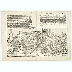
Destruccio Iherosolime.
The view shows the destruction of Jerusalem. Major points in the city are identified with Latin notations. Of interest, in the upper left of the image are two figures...
- $2000 / ≈ €1871
Place & Date: Nuremberg, 12 July 1493
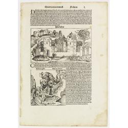
Quarta etas mundi Folium L. ( Jericho, The Prophet Elijah Ascending to Heaven...)
Panoramic view of Jericho. An imaginary view: however, the earliest obtainable view of this period. Underneath The Prophet Elijah Ascending to Heaven in a Fiery Chariot, ...
- $350 / ≈ €328
Place & Date: Nuremberg, 12 July 1493
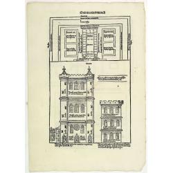
Quinta Etas Mundi. Folium. LXVI. (Visionary Temple of Ezekiel.)
The Latin text page is illustrated with recto and verso depictions of the visionary Temple of Ezekiel. Kings.Page from the richest illustrated Incunable, the famous: Chro...
- $200 / ≈ €187
Place & Date: Nuremberg, 12 July 1493
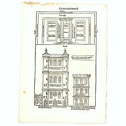
Quinta Etas Mundi. Folium. LXVI. (Visionary Temple of Ezekiel.)
The Latin text page is illustrated with on recto and verso depictions of the visionary Temple of Ezekiel. Kings.Page from the richest illustrated Incunable, the famous: N...
- $200 / ≈ €187
Place & Date: Nuremberg, 12 July 1493
![[Map of Palestine ]](/uploads/cache/42176-250x250.jpg)
[Map of Palestine ]
Map of Palestine from "La Mer des Hystoires" published by Dupré, Paris, 1536 "La Mer des Hystoires" is a translation into French of the famous "...
Place & Date: Dupre, Paris, 1536
![.[Near east with Cyprus]](/uploads/cache/33857-250x250.jpg)
.[Near east with Cyprus]
Wood block printed map and one of earliest printed representation of Near east with Cyprus prepared by Martin Waldseemüller. Based on the slightly larger map from 1513 p...
Place & Date: Vienna, 1525 -1541

Tabula Asiae IIII. (Cyprus, Holy Land, Syria, Jordan, Iraq)
Gastaldi's map showing Cyprus, the Holy Land, Syria, Jordan and Iraq, based upon Ptolemy's map It is one of the earliest obtainable maps of the region.From Giacomo Gastal...
- $350 / ≈ €328
Place & Date: Venice, 1548
![[Lot of 8 leaves relating to the Holy Land]](/uploads/cache/48279-250x250.jpg)
[Lot of 8 leaves relating to the Holy Land]
Eight printed text leaves with maps and views relating to the Holy Land. From the 1552 Latin text edition of Münster's Cosmographia, which is a short and complete summar...
- $100 / ≈ €94
Place & Date: Basel, 1552
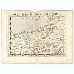
Tavola nuova di Prussia et di Livonia.
Uncommon first edition of this early map of the region from Pomerania to Livonia, includes a portion of Estonia, and coastal detail on the Baltic Sea with a small section...
- $400 / ≈ €374
Place & Date: Venice, Vincenzo Valgrisi, 1561
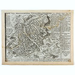
Novae Urbis Hierosolymitanae topographica delineatio . . .
A very rare plan of modern Jerusalem oriented to the east, according to a note on the map the map was drawn after a map by Peter Laicstain. A lettered key to the right.Up...
- $2500 / ≈ €2339
Place & Date: Antwerp, 1571