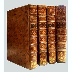
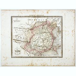
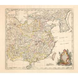
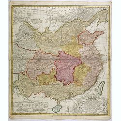
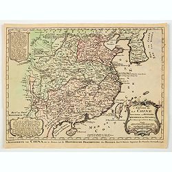
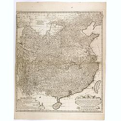
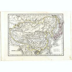
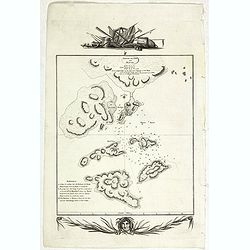
Description geographique, historique, chronologique, politique, et physique de l'empire de la Chine et de la Tartarie chinoise.
First edition of this cornerstone of any collection of books on China, which is also among the rarest and most desirable of important Americana, included in Rare American...
Place & Date: Paris, P. G. Le Mercier, 1735
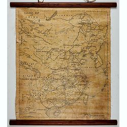
Railway map of China.
Railway map of China. Key in the left with keys to capital cities, Ocean cables, etc. Published by The Chinese Government Bureau of Economic Information, which was a nonp...
- $350 / ≈ €328
Place & Date: China, ca. 1928
![[Lot of 6] Carte de la Baye d'Hocsieu. Fukin. (3 Maps + 3 Gravure of China)](/uploads/cache/IMG_2524-250x250.jpg)
[Lot of 6] Carte de la Baye d'Hocsieu. Fukin. (3 Maps + 3 Gravure of China)
[Lot of 6 items]. (3 Maps +3 gravure )- Carte de la Baye d'Hocsieu et des Entrees de la Riviere de Chang Situees dans la Province de Fokyen. J.N.Berlin 1748- Carte de l�...
Place & Date: Amsterdam, 1759
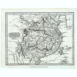
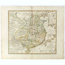
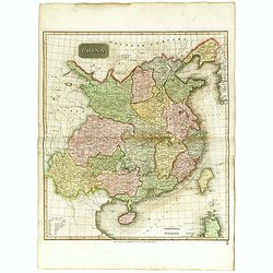
China.
From the atlas the 'Universal Geography' by Thos. Kelly, and engraved by Finlay. This copper plate maps shows the mainland of China, together with the islands of Formosa ...
Place & Date: London, ca. 1817
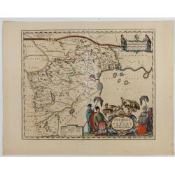
Pecheli sive Peking imperii sinarum provincia prima.
The map of the province of Peking from Joan Blaeu's Novus Atlas Sinensis , the first atlas of China with maps by the hand of the Italian Jesuit Martino Martini. A beautif...
Place & Date: Amsterdam, 1640
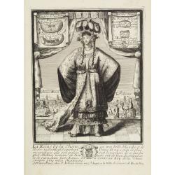
La Reine de la chine.
Very rare and decorative costume plate. In the background : Palais Royal Peking. Beneath the plate a descriptive text about the Queen of China.Bears the address : Se vend...
Place & Date: Paris, ca. 1685
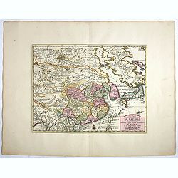
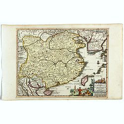
Quantung Imperii Sinarum Provincia duodecima.
A beautifully engraved map of Southern China covers Hainan, the Pearl River Delta, and Greater Hong Kong.A legend at left identifies cities and towns of various sizes, fo...
Place & Date: Amsterdam, 1660
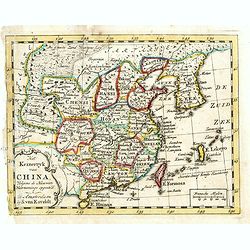
China-Propria oder das eigentliche China.
Map number 48 from Meyer's 'Zeitung's Atlas', a popular German 'pocket atlas', published during the mid nineteenth century. This map of China shows the mainland, and the ...
Place & Date: Hildburghausen / Philadelphia, 1849
China.
Map of China, Taiwan and Korea. This map by the nephew of Aaron Arrowsmith first appeared in 1832 and was reissued several times. The present issue appeared in Arrowsmith...
Place & Date: London, 1838
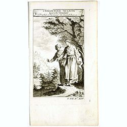
1. Seigneure Delassa tirés de Grueber. 2. Trophée à l'honneur du Grand Lama. (Tibet).
Fanciful European depiction of people from Tibet and Lhassa. A somewhat larger image appeared in "Abbe A.F. Prévost, Histoire Generale des Voyages".
Place & Date: Paris, ca. 1750
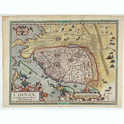
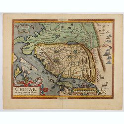
Chinae, olim Sinarum regionis. . .
The first printed map of China. It is signed by Ludovico Georgio, whose real name was Luis Jorge de Barbuda. He was a Portuguese Jesuit cartographer and besides that a sp...
Place & Date: Antwerp, 1598
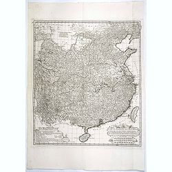
Carte Generale de la Chine Dressée sur les Cartes Particulieres Que l' Empereur Chang-Hi a fait lever sur les lieux..
Large map showing the traditional limits of China, including Hainan and Formosa in the South, and Quantong and parts of the Gobi Desert in the North.As the title notes, t...
Place & Date: Paris, Ph.-D. Pierres, Clousier [- Moutard], 1785
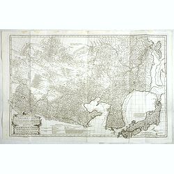
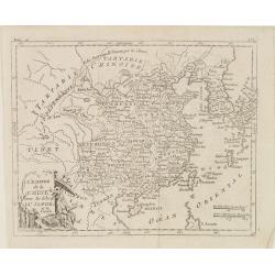
Carte Generale De La Tartarie Chinoise Dressee sur les Cartes Particulieres Faits Sur Les Lieux Par Les R.R. P.P. Jesuites . . . .MDCCXXXII
Very detailed map of Northern China, Japan and Korea. Jean Baptiste Bourguignon d' Anville (1697-1782), French cartographer. d'Anville used maps prepared by Jesuit missi...
Place & Date: Paris, Ph.-D. Pierres, Clousier [- Moutard], 1785
La Cina propriamente detta e sue isole.
Uncommon map of China prepared by Francesco Costantino Marmocchi. Above the map "Geografia Commerciale". From "Il Globo Atlante di carte Geografiche compil...
Place & Date: Genova, Paolo Rivara fu Giacomo, 1858
Charte von China nach Murdochischer Projection entworfen. ... Berichtiget, und gezeichnet von H.F.A. Stieler. . .
Uncommon map of China prepared by H.F.A.Stieler, with parts of Taiwan, Tibet, Mongolia and the Korean peninsula, with a great many place names, a key to (and brief explan...
Place & Date: Augsburg, 1820
Nouvelle Carte de L'Empire De La Chine et les Pais circonvoisins - Nieuwe Kaart van t Keizerryk China en de aangrensende Landen.
Finely engraved map of China and Korea, with titles in both French and Dutch.The map extends west to the Gobi Desert and Tibet and shows Macao and Canton, among other cit...
Place & Date: Amsterdam, 1750
L'Empire de la Chine, avec les Isles du Japon, et la Corée.
Map of south eastern China, including Taiwan, Korea and Japan. From Atlas de la Géographie de toutes les parties du monde .. Ouvrage destiné pour l'education, et néces...
Place & Date: Paris, Prudhomme, Levrault, Debray, 1806
China as surveyed by the Jesuit Misionaries between the years 1708 & 1717 with Korea & the adjoining parts of Tartary.
The map is of interest for the use of Eastern Sea or Sea of China, the sea south of Korea. In the sea along the coast line of Korea : "Kau-Li-Qua or King:m of Korea&...
Place & Date: London, c. 1760
Selling price: $500
Sold in 2014
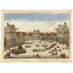
Le dedans du Palais de l'Empereur de Chine à Peking.
This so called optical print shows the imperial palace, the Forbidden City in Peking, China. In the foreground a large courtyard is depicted, surrounded by buildings. Thr...
Place & Date: Augsburg, 1760
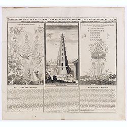
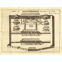
Description d'un des plus fameux temples des Chinois..
This impressive engraving is a wonderful example of Chatelain’s elegant plates.Divided in 3 panels, respectively showing the most important gods in the Chinese deities ...
Place & Date: Amsterdam, ca. 1720
China.
Highly detailed map of China including Formosa (Taiwan), Hainan, and part of Luzon in the Philippines. The map show the Tract of the Hindoostan and Lion with the British ...
Place & Date: Edinburgh, 1815
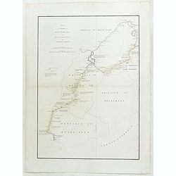
Sketch of A Journey from Hang-Tchoo-Foo To Quang-Tchoo-Foo or Canton in China.
A detailed map taken from, from Staunton's 'An Authentic Account of an Embassy from the King of Great Britain to the Emperor of China'.The map shows the second part of Ma...
Place & Date: London, 1796
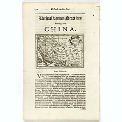
La Chine Royaume. . .
An important and attractive French map of the whole of China, northern tip of the Philippines, with a strangely curved Korea and an under-sized Taiwan here called "Y...
Place & Date: Paris, 1656
Carte de la Chine et du Japon..
Engraved by Tardieu for L'Intelligence de l'histoire generale des Voyages de Laharpe .Rare and detailed map of China, Korea, Japan and Taiwan (I.Formose ou Pekan).
- $100 / ≈ €94
Place & Date: Paris, 1821
![[8 sheets - Partie du THIBET]](/uploads/cache/36629-250x250.jpg)
[8 sheets - Partie du THIBET]
A set of 8 maps covering Tibet region and the Himalayas.From his famous Atlas Universel . This atlas was one of the most remarkable world atlases ever produced, anticipat...
- $1000 / ≈ €936
Place & Date: Brussels, 1825-1827
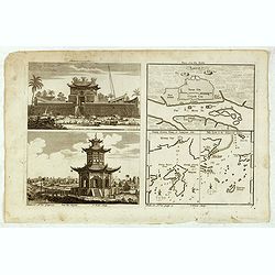
Chinese Temples. Sin-Ko-Tsyen. Canton, Sancian Isle. Ma-Kao.
An attractive print divided into four areas, two depicting Chinese temples and the other two with maps of the city of Canton, the island of Sancian and the island of Ma-K...
- $75 / ≈ €70
Place & Date: London, 1745-1747
Regni Sinae vel Sinae propriae. . .
General map of China extending to the Gobi Desert in the North, including the islands of Taiwan and Hainan. The map is based on the work of du Halde. An appealing title c...
- $750 / ≈ €702
Place & Date: Nuremberg, 1760
Nouvelle Carte de L'Empire De La Chine et les Pais circonvoisins - Nieuwe Kaart van t Keizerryk China en de aangrensende Landen.
Finely engraved map of China and Korea, with titles in both French and Dutch.The map extends west to the Gobi Desert and Tibet and shows Macao and Canton, among other cit...
- $500 / ≈ €468
Place & Date: Amsterdam, 1750
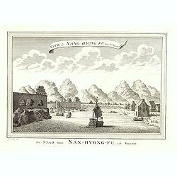
Cité de Nang Hyong Fu, tiree the Nieuhof. De Stad van Nan-Hyong-Fu, uit Nieuhof.
Interesting view of Nan-Hyong-Fu with harbour and fort.Prepared by Jacques Nicolas Bellin and included in a Dutch edition of Prévost d' Exile's "Histoire des Voyage...
- $50 / ≈ €47
Place & Date: The Hague, Pieter de Hondt, 1747-1767
![Plans de Quelques Villes de la Province de Hou-Quang. / Grondtekening [floor plan] van eenige Steden van't Landschap Hu-Quang.](/uploads/cache/34078-250x250.jpg)
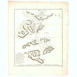
Plans de Quelques Villes de la Province de Hou-Quang. / Grondtekening [floor plan] van eenige Steden van't Landschap Hu-Quang.
Interesting set of three local town plans each with extensive titles :"Yong Chew Fu, ou Yong Tcheou Fou." Centre: "Vu Chang Fu, ou Vou-Tchang-Fou Capitale:...
- $90 / ≈ €84
Place & Date: The Hague, Pieter de Hondt, 1747-1767
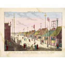
Vue de la Rue des Marchands Chinoises a Nankin.
So-called optical print illustrating a parade of vessels. Engraved by F.X. Habermann (1721-1796). The Academie Imperiale was a well-known publisher of optical prints, est...
- $500 / ≈ €468
Place & Date: Augsburg, 1760
L'Empire de La Chine../ 't Keizerryk van China..
An attractive map of China with Korea and Taiwan (I.Tay-wan, ou Formosa) and "Mer de Coree'. There are decorative title cartouches in three corners of the map. The u...
- $200 / ≈ €187
Place & Date: The Hague, 1773
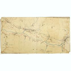
Boucle du Pei-Ho.
Manuscript map of Boucle du Pei-Ho (Taku Forts) showing the river Pei-ho, along with the projected railway lines were to be built, including bridges, installations, villa...
- $750 / ≈ €702
Place & Date: China ?, ca.1910
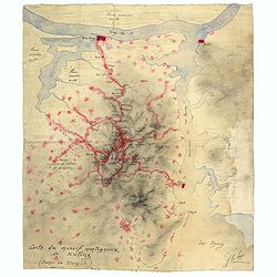
Carte du massif montagneux de Kuling (Province de Kiand-Si).
Manuscript map of the Kuling mountain range, showing the YangTze River, Lake Poyang, villages, etc. in French. Signed J.Volaz (?).Guling (or Kuling), is a resort town in ...
- $1500 / ≈ €1404
Place & Date: China ?, ca.1930
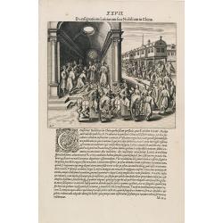
A Parade of Noblemen in China.
This famous and desirable scene from Linschoten's famous voyages to the East of 1583-92 here published by De Bry the year after they first appeared as a separate book. Fr...
- $150 / ≈ €140
Place & Date: Frankfurt, 1599
Naves Chinensibus usitatae velis arundineis & anchoris ligneis.
A Chinese vessel. Print taken from Linschoten's famous voyages to the East of 1583-92 here published by De Bry the year after they first appeared as a separate book. Fro...
- $200 / ≈ €187
Place & Date: Frankfurt, 1599
Plan du Typa, ou de Macao.
A pleasant copper engraving of Typa, Macao. By Rigobert Bonne from his ATLAS ENCYCLOPEDIQUE published in 1780. Engraved by Andre.Rigobert Bonne (1727-1795) was one of the...
- $100 / ≈ €94
Place & Date: Paris, 1780
Vue de la Côte du Japon lorsque nous la vimespour la 1ere fois La Coline A restant dans l'O à 3 Millerc.
A pleasant copper engraving of Japan coasts. By Rigobert Bonne from his ATLAS ENCYCLOPEDIQUE published in 1780. Engraved by Andre.Rigobert Bonne (1727-1795) was one of th...
- $100 / ≈ €94
Place & Date: Paris, 1780
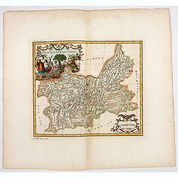
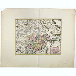
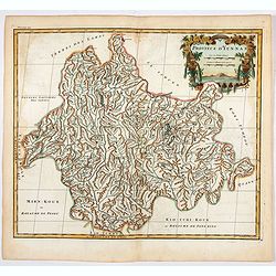
Province de Koei-Tcheou.
An important map of Koei-tcheou 贵州 [Guizhou]. With a quite elaborately pictorial cartouche featuring a rococo chinoiserie ornamentation engraved by Guélard, the map ...
- $100 / ≈ €94
Place & Date: Paris, P.G. Le Mercier, 1735
Province d'Yun-Nan.
Important map of Yun-nan 云南 [Yunnan] province. With a quite elaborately pictorial cartouche featuring a rococo chinoiserie ornamentation, engraved by Delahaye. Jean B...
- $75 / ≈ €70
Place & Date: Paris, P.G. Le Mercier, 1735
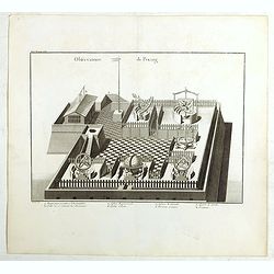
Observatoire de Peking.
The observatory of Mateo Rizzi in Peking, in which there are very large instruments, an Equinoctial Sphere, a Celestial Globe, a Zodiacal Sphere, Azimuthal Horizona, Quad...
- $200 / ≈ €187
Place & Date: Paris, GROSIER Jean-Baptiste, 1785
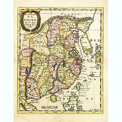
La Chine suivant les nouvelles observations...
Uncommon edition of this map of China. From Le Nouveau Theatre du Monde, ou la Geographie Royale.Curious shape of South Korea.
- $1100 / ≈ €1029
Place & Date: Amsterdam, 1728
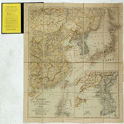
Stanford's Map of Eastern China, Japan and Korea. 1898.
Charming, folding map of the east coast of China, Korea and Japan. In the lower right corner inset map of Korea (265x512mm.). In the lower left, a key to Treaty Ports, Su...
- $750 / ≈ €702
Place & Date: London, ca. 1898
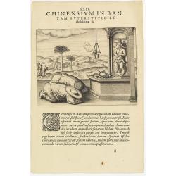
Chinensium in Bantam Superstitio et idololatria. 18. ( How the Chinese worship their idols in Bantam)
How the Chinese worship their idols in Bantam. As can be seen here, the Chinese worship their idol, which takes the form of a devil. They lay offerings of fruit on an alt...
- $100 / ≈ €94
Place & Date: Frankfurt, 1609
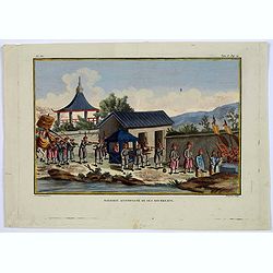
Mandarin accompagne de ses Bourreaux.
A copperplate taken from volume 2 of the work by Sonnerat titled: 'Voyage aux Indies Orientales et a Chine, fait par ordre du Roi, depuis 1774-1781…'.This colored coppe...
- $125 / ≈ €117
Place & Date: Paris, ca. 1782
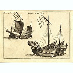
Jonques de la Chine.
A depiction of two Chinese junks. Tome 3 Page 377. From the French reissue of the account of early Dutch voyages first published in 1608 by Commelin. The French translati...
- $75 / ≈ €70
Place & Date: Amsterdam, J.F. Bernard, 1725
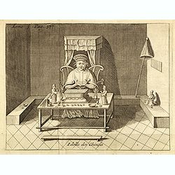
Idolle des Chinois.
Print of a Chinese divinity. Tome 3 Page 377 in upper left corner. From the French reissue of the account of early Dutch voyages first published in 1608 by Commelin. The ...
- $75 / ≈ €70
Place & Date: Amsterdam, J.F. Bernard, 1725
Palais de Lamthau à la Chine.
View of a Mandarin's Palace at Lantau Island, showing the palace wall, 3 gates and guards in the inner palace where the Mandarin meets with the officers.. Tome 3 Page 392...
- $75 / ≈ €70
Place & Date: Amsterdam, J.F. Bernard, 1725
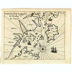
Embouchure de la rivière de Chincheo à la Chine.
This map is a view of Quanzhou Bay. Quanzhou was established in 718 during the Tang Dynasty (618–907). In those days, Guangzhou was China's greatest seaport, but this s...
Place & Date: Amsterdam, F. Bernard, 1725
Selling price: $110
Sold in 2014
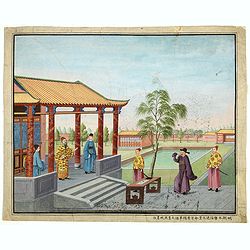
Chinese Export watercolor.
Chinese watercolor with in lower margin Chinese text : Chinese watercolor - " A farmer's thief, a book, a big manuscipt, a filial piety, a martial art. " [Googl...
- $1000 / ≈ €936
Place & Date: China, ca. 1850
Chinae, olim Sinarum Regionis, nova descriptio. Auctore Ludovico Georgio.
The first map of China ever to appear in a Western atlas, west to the top. The second state with "Las Philipinas" somewhere in 1587 added to the plate. When thi...
- $6000 / ≈ €5614
Place & Date: Antwerp, 1592
Carte générale de la Chine Dressée sur les Cartes particulières que l'Empereur Cang-hi a fait lever sur les lieux par les RR. PP. Jésuites missionaires dans cet empire / Par le Sr d'Anville.
Important and very detailed map of Southern part of China, including a detailed Taiwan. Jean Baptiste Bourguignon d' Anville (1697-1782) was a French cartographer and com...
- $1000 / ≈ €936
Place & Date: The Hague, H. Scheurleer, 1737
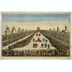
Vue perspective de la grande Ceremonie du Couronnement de l'Empereur de la Chine.
So-called optical print illustrating the crowning of the Chinese emperor. It shows the throne at the center.Mondhare was a well-known publisher of optical prints, establi...
- $450 / ≈ €421
Place & Date: Paris, 1761
Het Keizerryk van China, volgens de Nieuwste Waarneminge opgesteld.
A scarce and uncommon miniature map of China, Korea and Taiwan. The map is of interest for the use of De Zuid Zee for the sea between Korea and Japan.
- $300 / ≈ €281
Place & Date: Amsterdam, 1745
Royaume de la Chine. . .
Detailed map of China. Engraved by A.Winter. Attractive miniature map, depicting Korea as an island and parts of Japan, i.e. western part of Honshu and Kyushu.
- $450 / ≈ €421
Place & Date: Utrecht, 1683
![[assorted Chinese musical instruments].](/uploads/cache/37968-250x250.jpg)
[assorted Chinese musical instruments].
A delightful copperplate print of 15 assorted Chinese musical instruments including gong, bell, drum, cymbals etc.
- $35 / ≈ €33
Place & Date: Germany, ca. 1812
![[XL. Sepolcro di un Grande].](/uploads/cache/34993-250x250.jpg)
[XL. Sepolcro di un Grande].
Aquatint depicting the tomb engraved by L. Rolsi. Plate N°40.From Giulio Ferrario's work Le Costume Ancien et Moderne ou Histoire du gouvernement, de la milice, de la re...
- $40 / ≈ €37
Place & Date: Milan, 1827
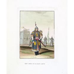
Soldato nel suo compito uniforme (Chinese soldier in full battle dress)
Aquatint with original coloring by Antonio Rancati, taken from Giulio Ferrario's work Le Costume ancien et moderne ou histoire du gouvernement, de la milice, de la religi...
- $80 / ≈ €75
Place & Date: Milan, 1827
Tende, Stendardi (Chinese Military Equipment)
Aquatint with original coloring by Antonio Rancati, taken from Giulio Ferrario's work Le Costume ancien et moderne ou histoire du gouvernement, de la milice, de la religi...
- $80 / ≈ €75
Place & Date: Milan, 1827
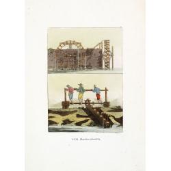
Macchine idrauliche. (Chinese hydraulic machines)
Aquatint with original coloring by G. Rossi, taken from Giulio Ferrario's work Le Costume ancien et moderne ou histoire du gouvernement, de la milice, de la religion, des...
- $50 / ≈ €47
Place & Date: Milan, 1827
![[XXXII. Dio Quante-Cong].](/uploads/cache/34992-250x250.jpg)
[XXXII. Dio Quante-Cong].
Aquatint depicting Chinese Idol Quantecong, who was the first Emperor, engraved by G Zancon, Plate N°32.From Giulio Ferrario's work Le Costume Ancien et Moderne ou Histo...
- $50 / ≈ €47
Place & Date: Milan, 1827
![[LXVIII. Abiti de' cittadini e de' contadini].](/uploads/cache/34991-250x250.jpg)
[LXVIII. Abiti de' cittadini e de' contadini].
Aquatint costume plate showing Chinese citizens and farmers engraved by G. Bigatti, Plate N°68.From Giulio Ferrario's work Le Costume Ancien et Moderne ou Histoire du go...
- $50 / ≈ €47
Place & Date: Milan, 1827
![[Antico Imperatore nel suo carro].](/uploads/cache/34990-250x250.jpg)
[Antico Imperatore nel suo carro].
Aquatint depicting an Emperor in his chariot engraved by G. Bigatti, Plate N°13.From Giulio Ferrario's work Le Costume Ancien et Moderne ou Histoire du gouvernement, de ...
- $50 / ≈ €47
Place & Date: Milan, 1827
![[LXXXIII. Nozze].](/uploads/cache/34987-250x250.jpg)
[LXXXIII. Nozze].
Aquatint depicting a Chinese wedding ceremony engraved by A. Rancati, Plate N°83.From Giulio Ferrario's work Le Costume Ancien et Moderne ou Histoire du gouvernement, de...
- $50 / ≈ €47
Place & Date: Milan, 1827
![[XIX. Principali persone componenti la marcia ec..].](/uploads/cache/34986-250x250.jpg)
[XIX. Principali persone componenti la marcia ec..].
Aquatint depicting a Chinese procession, engraved by G. Zacon, Plate N°16.From Giulio Ferrario's work Le Costume Ancien et Moderne ou Histoire du gouvernement, de la mil...
- $50 / ≈ €47
Place & Date: Milan, 1827
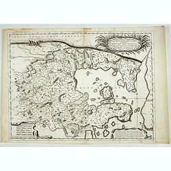
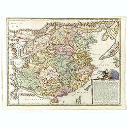
Xantung, e Peking provincie della china. . .
A beautiful map depicting the area of Beijing with decorative title cartouche and scale cartouche. Information about the area at the top of the map.To the right the west ...
- $350 / ≈ €328
Place & Date: Venice, 1698
![[LXXXI. Amida e Xaca ].](/uploads/cache/34985-250x250.jpg)
[LXXXI. Amida e Xaca ].
Aquatint depicting Amida (or Amideva who is a celestial Buddha) and the God Xaca, engraved by A.Rancati. Plate N°81.From Giulio Ferrario's work Le Costume Ancien et Mode...
- $40 / ≈ €37
Place & Date: Milan, 1827
![[LVI. Strada di Nan-King].](/uploads/cache/34984-250x250.jpg)
[LVI. Strada di Nan-King].
Aquatint depicting a street in Nanking (Nanjing) engraved by G Zancon, Plate N°56.From Giulio Ferrario's work Le Costume Ancien et Moderne ou Histoire du gouvernement, d...
- $50 / ≈ €47
Place & Date: Milan, 1827
![[XXV Cavalleria ].](/uploads/cache/34983-250x250.jpg)
[XXV Cavalleria ].
Aquatint depicting Chinese cavalry engraved by G Bigatti, Plate N°25.From Giulio Ferrario's work Le Costume Ancien et Moderne ou Histoire du gouvernement, de la milice, ...
- $50 / ≈ €47
Place & Date: Milan, 1827
![[XXIII Infanteria ].](/uploads/cache/34982-250x250.jpg)
[XXIII Infanteria ].
Aquatint depicting Chinese infantry engraved by G Bigatti, Plate N°23.From Giulio Ferrario's work Le Costume Ancien et Moderne ou Histoire du gouvernement, de la milice,...
- $50 / ≈ €47
Place & Date: Milan, 1827
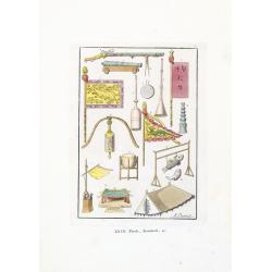
![[assorted Chinese musical instruments].](/uploads/cache/37969-250x250.jpg)
[assorted Chinese musical instruments].
A delightful copperplate print of 15 assorted Chinese musical instruments including violin, flute, trumpet, guitars, cymbals etc.
- $30 / ≈ €28
Place & Date: Germany, ca. 1812
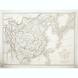
Chine et Japon.
Detailed map of China, Korea, Taiwan and Japan, prepared by Charles V. Monin (fl.1830-1880) a French cartographer of Caen and Paris. Published in Atlas Universel de Géog...
- $75 / ≈ €70
Place & Date: Paris, 1845
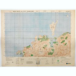
Hong Kong and New Territory - Tai O.
A third edition air survey map of this mainland portion of north west Hong Kong and New Territory, performed by the RAF. Originally published in 1931, then with minor cor...
- $400 / ≈ €374
Place & Date: London, 1945
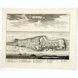
Platte Grond vande Stadt Macao.
A fine view of the city of Macao from Lappa Island showing in schematic blocks the structure of the town. With European vessels and junks in the surrounding water. With n...
- $750 / ≈ €702
Place & Date: Amsterdam, 1724
China.
Small map illustrating China with the Great Wall and Korea as an island, surrounded by text in Dutch.Nicolaes de Clerck (de Klerc) was active as engraver and publisher in...
- $200 / ≈ €187
Place & Date: Amsterdam, Cloppenburch, 1621
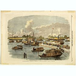
Sick and wounded embarking at Hong-Kong on Board the Steamer.
Large view of the harbour with numerous ships and people. From the Illustrated London News, October 23, 1858.
- $75 / ≈ €70
Place & Date: London, October 1858
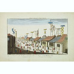
Vue perspective de la grande Rue de Nanquin ancienne Ville de la Chine.
So-called optical print of a street in Nanking. The wide boulevard is lined with merchants displaying their wares with colorful flags and signs. The street is filled with...
- $500 / ≈ €468
Place & Date: Paris, c.1780
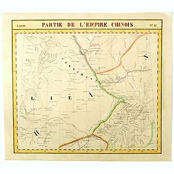
Partie de L'Empire Chinois - No.47.
One of Vandermaelen's 378 conjoined maps on a uniform scale to made up the total globe. This map features the Eastern Mongolia portion of China with Oloa Baytin. Interest...
- $75 / ≈ €70
Place & Date: Brussels, 1825-1827
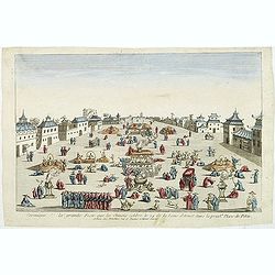
Ceremonie de la grande Feste que les Chinois celebre le 24 de la Lune d'Aoust dans la principale Place de Pekin.
So-called optical print illustrating the festivities on the 24th of August in Beijing.Mondhare was a well-known publisher of optical prints, established in Paris, at rue ...
- $500 / ≈ €468
Place & Date: Paris, c.1780
Sketch of the Typa and Macao.
A map of the environs of the Portuguese settlement of Macao in the Far East. The map shows a small town plan of Macao, nearby rocks, shoals depth soundings, and a few nav...
- $150 / ≈ €140
Place & Date: London, 1785