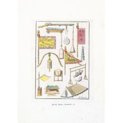
Tende, Stendardi (Chinese Military Equipment)
Aquatint with original coloring by Antonio Rancati, taken from Giulio Ferrario's work Le Costume ancien et moderne ou histoire du gouvernement, de la milice, de la religi...
- $80 / ≈ €70
Date: Milan, 1827
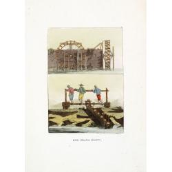
Macchine idrauliche. (Chinese hydraulic machines)
Aquatint with original coloring by G. Rossi, taken from Giulio Ferrario's work Le Costume ancien et moderne ou histoire du gouvernement, de la milice, de la religion, des...
- $50 / ≈ €44
Date: Milan, 1827
![[XXIII Infanteria ].](/uploads/cache/34982-250x250.jpg)
[XXIII Infanteria ].
Aquatint depicting Chinese infantry engraved by G Bigatti, Plate N°23.From Giulio Ferrario's work Le Costume Ancien et Moderne ou Histoire du gouvernement, de la milice,...
- $50 / ≈ €44
Date: Milan, 1827
![[XXV Cavalleria ].](/uploads/cache/34983-250x250.jpg)
[XXV Cavalleria ].
Aquatint depicting Chinese cavalry engraved by G Bigatti, Plate N°25.From Giulio Ferrario's work Le Costume Ancien et Moderne ou Histoire du gouvernement, de la milice, ...
- $50 / ≈ €44
Date: Milan, 1827
![[LVI. Strada di Nan-King].](/uploads/cache/34984-250x250.jpg)
[LVI. Strada di Nan-King].
Aquatint depicting a street in Nanking (Nanjing) engraved by G Zancon, Plate N°56.From Giulio Ferrario's work Le Costume Ancien et Moderne ou Histoire du gouvernement, d...
- $50 / ≈ €44
Date: Milan, 1827
![[LXXXI. Amida e Xaca ].](/uploads/cache/34985-250x250.jpg)
[LXXXI. Amida e Xaca ].
Aquatint depicting Amida (or Amideva who is a celestial Buddha) and the God Xaca, engraved by A.Rancati. Plate N°81.From Giulio Ferrario's work Le Costume Ancien et Mode...
- $40 / ≈ €35
Date: Milan, 1827
![[XIX. Principali persone componenti la marcia ec..].](/uploads/cache/34986-250x250.jpg)
[XIX. Principali persone componenti la marcia ec..].
Aquatint depicting a Chinese procession, engraved by G. Zacon, Plate N°16.From Giulio Ferrario's work Le Costume Ancien et Moderne ou Histoire du gouvernement, de la mil...
- $50 / ≈ €44
Date: Milan, 1827
![[LXXXIII. Nozze].](/uploads/cache/34987-250x250.jpg)
[LXXXIII. Nozze].
Aquatint depicting a Chinese wedding ceremony engraved by A. Rancati, Plate N°83.From Giulio Ferrario's work Le Costume Ancien et Moderne ou Histoire du gouvernement, de...
- $50 / ≈ €44
Date: Milan, 1827
![[Antico Imperatore nel suo carro].](/uploads/cache/34990-250x250.jpg)
[Antico Imperatore nel suo carro].
Aquatint depicting an Emperor in his chariot engraved by G. Bigatti, Plate N°13.From Giulio Ferrario's work Le Costume Ancien et Moderne ou Histoire du gouvernement, de ...
- $50 / ≈ €44
Date: Milan, 1827
![[LXVIII. Abiti de' cittadini e de' contadini].](/uploads/cache/34991-250x250.jpg)
[LXVIII. Abiti de' cittadini e de' contadini].
Aquatint costume plate showing Chinese citizens and farmers engraved by G. Bigatti, Plate N°68.From Giulio Ferrario's work Le Costume Ancien et Moderne ou Histoire du go...
- $50 / ≈ €44
Date: Milan, 1827
![[XXXII. Dio Quante-Cong].](/uploads/cache/34992-250x250.jpg)
[XXXII. Dio Quante-Cong].
Aquatint depicting Chinese Idol Quantecong, who was the first Emperor, engraved by G Zancon, Plate N°32.From Giulio Ferrario's work Le Costume Ancien et Moderne ou Histo...
- $50 / ≈ €44
Date: Milan, 1827
![[XL. Sepolcro di un Grande].](/uploads/cache/34993-250x250.jpg)
[XL. Sepolcro di un Grande].
Aquatint depicting the tomb engraved by L. Rolsi. Plate N°40.From Giulio Ferrario's work Le Costume Ancien et Moderne ou Histoire du gouvernement, de la milice, de la re...
- $40 / ≈ €35
Date: Milan, 1827
![[8 sheets - Partie du THIBET]](/uploads/cache/36629-250x250.jpg)
[8 sheets - Partie du THIBET]
A set of 8 maps covering Tibet region and the Himalayas.From his famous Atlas Universel . This atlas was one of the most remarkable world atlases ever produced, anticipat...
Date: Brussels, 1825-1827
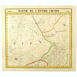
Partie de L'Empire Chinois - No.47.
One of Vandermaelen's 378 conjoined maps on a uniform scale to made up the total globe. This map features the Eastern Mongolia portion of China with Oloa Baytin. Interest...
- $75 / ≈ €65
Date: Brussels, 1825-1827
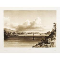
Macao.
Early view of Macao after Barthelemy Lauvergne (1805-1875) and engraved in aquatint technique by Sigismond Himely (1801-1872). Published as plate 28 in Voyage autour du m...
- $600 / ≈ €524
Date: Paris, Finot, 1835
China.
Map of China, Taiwan and Korea. This map by the nephew of Aaron Arrowsmith first appeared in 1832 and was reissued several times. The present issue appeared in Arrowsmith...
Date: London, 1838
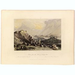
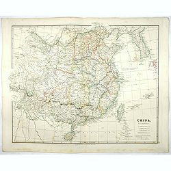
Macao from the Forts of Heang-shan.
A finely delineated view of the city of Macao as seen from one of its fortification areas. The foreground contains a group of religious worshipers. Engraved by S. Fisher....
- $150 / ≈ €131
Date: London, ca. 1840
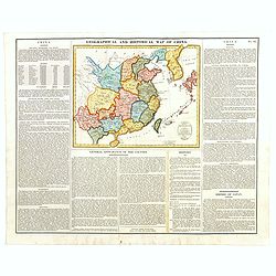
Geographical and Statistical Map of China. China and the Tributary Kingdom of Corea. For the Elucidation of Lavoisne's Genealogical, Historical, Chronological, & Geographical Atlas, by C. Gros, 1820. No. 64. Revised 1828.
Fine map of China and Korea, with a sub-title in top "Geographical and historical map of China.". The map is apparently a revised edition for 1828.The atlas was...
- $450 / ≈ €393
Date: London, 1842
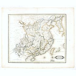
China.
This detailed map of China includes text giving measurements of "The Great Chinese Wall".The map was published in "Lizars' Edinburgh Geographical General A...
- $250 / ≈ €218
Date: Edinburg, 1842
Chine et Japon.
Detailed map of China, Korea, Taiwan and Japan, prepared by Charles V. Monin (fl.1830-1880) a French cartographer of Caen and Paris. Published in Atlas Universel de Géog...
- $75 / ≈ €65
Date: Paris, 1845
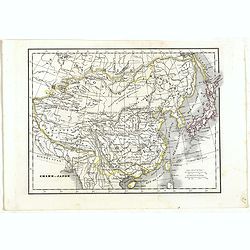
China-Propria oder das eigentliche China.
Map number 48 from Meyer's 'Zeitung's Atlas', a popular German 'pocket atlas', published during the mid nineteenth century. This map of China shows the mainland, and the ...
Date: Hildburghausen / Philadelphia, 1849
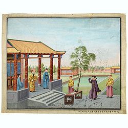
Chinese Export watercolor.
Chinese watercolor with in lower margin Chinese text : Chinese watercolor - " A farmer's thief, a book, a big manuscipt, a filial piety, a martial art. " [Googl...
- $1000 / ≈ €873
Date: China, ca. 1850
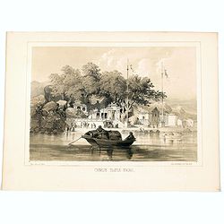
Chinese Temple, Macao.
A pleasant view of the important Chinese Temple in Macao, taken from the water with a junk in the foreground and many sampans and junks moored in front of it, with visito...
- $75 / ≈ €65
Date: Philadelphia, 1856
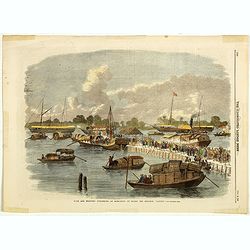
Sick and wounded embarking at Hong-Kong on Board the Steamer.
Large view of the harbour with numerous ships and people. From the Illustrated London News, October 23, 1858.
Date: London, October 1858
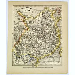
La Cina propriamente detta e sue isole.
Uncommon map of China prepared by Francesco Costantino Marmocchi. Above the map "Geografia Commerciale". From "Il Globo Atlante di carte Geografiche compil...
Date: Genova, Paolo Rivara fu Giacomo, 1858
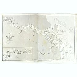
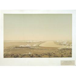
China, Sheet IX, Yang-Tse-Kiang from the sea to Nanking . . .
A fine, large-scale chart. This chart depicts the last stretch of the Yangtse River before it meets the sea. It gives soundings and notes on the tides, and includes an in...
- $750 / ≈ €655
Date: London, 1843-1859
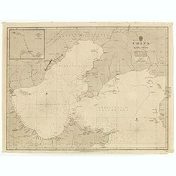
China east coast Yellow Sea and Gulf of Pechili
Very detailed chart of China's east coast with the Yellow Sea and Gulf of Pechili. Scale: circa 1:1m. Inscription: J & C Walker sculpt. One inset: Pekin to the Gulf o...
- $450 / ≈ €393
Date: London, 1840 - 1859

A fan combining views of Hong Kong (right), Canton (center), and Macau.
The fan shows nice images of Macau, Hong Kong and Canton on onside and on verso a garden with 45 characters welcoming a rider on his white horse. Their clothes are height...
Date: China, ca. 1850-1860
Militairy manuscript map of the end of Yangzi River across Shanghai, Jiangsu, and Zhejiang areas, with 3 red seals of the Ever-Victorious Army.
In the lower left corner, an inset plan of Songjiang District with Shanghai is shown with a grid, and the area is divided with red dotted border lines.The map has three r...
Date: China, ca 1862
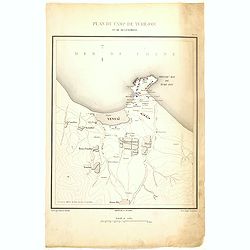
Plan de Camp de Tché-Fou et de ses environs.
A rare and detailed plan of Chefoo, which was a treaty port in Shantung province, near today's Yantai. Plate IV from "Atlas de l'expédition de Chine en 1860: rédig...
- $300 / ≈ €262
Date: Paris, 1862
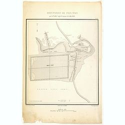
Occupation de Tien-Tsin par la Flottille Anglo-Française le 26 Mai 1859.
Plate III from "Atlas de l'expédition de Chine en 1860: rédigé au dépôt de la guerre d'après les documents officiels, étant directeur le général Blondel, so...
- $250 / ≈ €218
Date: Paris, 1862

Plan de la rade de Macao (chine) Levé d'après les ordres mr. Rocquemaurel.
Very detailed chart of Macao and several of the surrounding Islands, and features numerous depth soundings throughout. Prepared by captain, Gaston de Rocquemaurel. Logo o...
Date: Paris, c.1856 / 1863
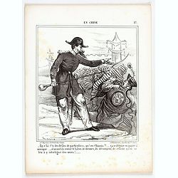
En Chine.
From the series "Caricatures du Prussien - Guerre des Duchés". Lithographed by Julés Pelcoq.
Date: Paris, 1864
Attaque & prise des forts du Pei-Ho Le 21 Août 1860, par les troupes Françaises et Anglaises.
In 1860, an Anglo-French force gathered at Hong Kong and then carried out a landing at Pei Tang on August 1, and a successful assault on the Taku Forts on August 21.This ...
- $500 / ≈ €436
Date: Paris, ca.1865

Carte du Kouy-Tchéou.
Detailed map of Guizhou Province prepared by Mgr. Faurie and other sources supplied by missionaries. Published in "Les Missions Catholique". Engraved by P. Méa...
Date: Lyon, c.1874
![Carte du Tche-Kiang. [ Zhejiang province ]](/uploads/cache/30921-250x250.jpg)
Carte du Tche-Kiang. [ Zhejiang province ]
Map of Tche Kiang, prepared by Bishop Edmond-François Guierry, C.M. (Vicar Apostolic of Zhejiang, China) after sources supplied by missionaries. Published in "Les M...
Date: Paris, 1874
(Set of 4 maps) Itinéraire de Pékin à Sartchy
Set of 4 geological maps from the "Nouvelle Archives du Museum" printed by Becquet.1) Route de Pekin a Suen-Hoa-Fou2) Route de Thae-Seu-Tchouang aux tentes mong...
Date: Paris, ca. 1880
![Hong Kong. [Queen's Road]](/uploads/cache/24362-250x250.jpg)
Hong Kong. [Queen's Road]
Finely executed watercolor made by Henri Dieth of a charming atmospheric street scene at Queen's Road in Hong Kong. The watercolor is made after Eduard Hildebrandt (1818-...
Date: Germany, 1882
![Hongkong Piratenstrasse. [Pirate Street]](/uploads/cache/24363-250x250.jpg)
Hongkong Piratenstrasse. [Pirate Street]
Finely executed watercolor made by Henri Dieth of a charming street scene at "Pirate Street" in Hong Kong. The watercolor is made after Eduard Hildebrandt (1818...
Date: Germany, 1882

Runde Strasse in Peking.
Finely executed watercolor made by Henri Dieth of a charming street scene in Peking. The watercolor is made after Eduard Hildebrandt (1818-1869). Hildebrandt, was born in...
Date: Germany, 1882
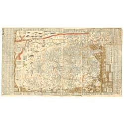
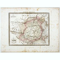
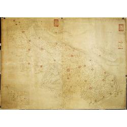
(Complete map of ancient and modern geography of China)
The second earliest edition of China’s first commercial map, Gujin di yu quan tu 《古今地輿全圖》(Complete map of ancient and modern geography of China) made du...
Date: Jingdu dashuntang, 1888
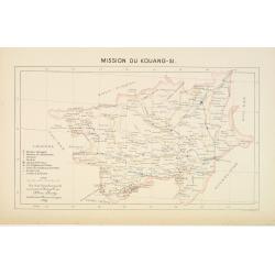
Mission du Kouang-Si.
Important missionary map showing part of China, prepared by Adrien Launay, who was a French Missionary and later chronicler of the history of the French Missions in Indo-...
Date: Lille, 1890
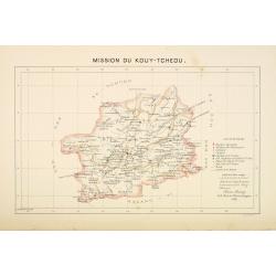
Mission du Kouy-Tcheou.
Important missionary map showing part of China, prepared by Adrien Launay, who was a French Missionary and later chronicler of the history of the French Missions in Indo-...
Date: Lille, 1890
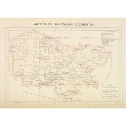
Mission du Sin-Tchuen occidental.
Important missionary map showing part of China, prepared by Adrien Launay, who was a French Missionary and later chronicler of the history of the French Missions in Indo-...
Date: Lille, 1890
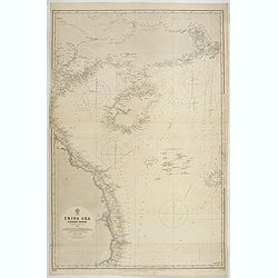
China Sea Nothern Porton compiled from the latest survey to 1884
A fine Survey chart no. 2680 showing Tong King Gulf, Hanan Island up to Hong Kong, Macao and Canto River up to Canton (Being)
- $800 / ≈ €698
Date: London, 1887, updated to 1897
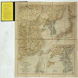
Stanford's Map of Eastern China, Japan and Korea. 1898.
Charming, folding map of the east coast of China, Korea and Japan. In the lower right corner inset map of Korea (265x512mm.). In the lower left, a key to Treaty Ports, Su...
- $750 / ≈ €655
Date: London, ca. 1898
![Nankin [Nanjing, Jiangsu]](/uploads/cache/30031-250x250.jpg)
Nankin [Nanjing, Jiangsu]
Very detailed (1:1.000.000) map showing the area north of Nanjing, Jiangsu. The French Service géographique des armées was founded in 1887 and provided the French milit...
Date: Paris, 1900
Peking. ( Pictorial map)
This pictorial map of this Game of the Goose, published at the time of the Boxer War, shows well the situation of Pei-Ho and Tientsin in relation to Peking. There are 42 ...
- $600 / ≈ €524
Date: France, ca.1901

COLLECTION OF HONG KONG MAPS, BOOKS & FLYERS. Including CHINA - HONGKONG surveyed by Captn. Sir Edward Belcher, in H.M.S. Sulphur 1841. Corrected to 1901.
A collection of 30 maps, prints, and publications relating to Hong Kong. Including : - BELCHER, E. Sir, An updated version of this most important nautical chart of Hong K...
Date: London, 1841 - 1901
![Wusung River or Hwang Pu. / Wusung River Entrance [With Shanhhai]](/uploads/cache/48595-250x250.jpg)
Wusung River or Hwang Pu. / Wusung River Entrance [With Shanhhai]
A fine Survey chart no. 1601 showing Wusung River or Hwang Pu. / Wusung River Entrance [With Shanghai]
- $800 / ≈ €698
Date: London, 1887 - 190, updated to 1903

CANTON Kong-Teheou.
Very detailed (1:1.000.000) map centered on Macao and Victoria Island, showing soundings, English, Australian, Danish telegraph lines reaching Hong Kong and extended to M...
Date: Paris, 1898 updated for june 1904
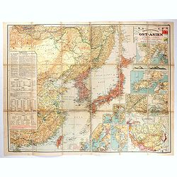
Übersichtskarte von Ost-Asien im Maßstabe 1: 5.000.000 mit 14 Beikarten in großen Maßstäben . . .
A large, uncommon map of East Asia prepared by Karl Peucker, and published by Ataria & Co. Striking and heavily annotated with information on China, Korea, Japan, and...
Date: Vienna, Artaria, 1904
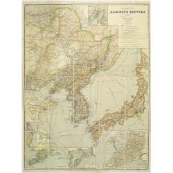
Map of the Far East
rare map including, Corea, Japan and China, prepared by Leonid Ivanovich Borodovsky, (1870-1906) and published in 1904. This folding map has several insets, one with Tai...
- $1000 / ≈ €873
Date: St. Petersburg, A.Ilyin, 1904
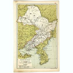
Manchuria.
Map of Manchuria and Korea. With in lower left corner scales in miles and kilometers, Protestant Mission Stations, railways both opened and in progress, canals and telegr...
- $75 / ≈ €65
Date: London, 1910
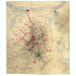
Boucle du Pei-Ho.
Manuscript map of Boucle du Pei-Ho (Taku Forts) showing the river Pei-ho, along with the projected railway lines were to be built, including bridges, installations, villa...
- $750 / ≈ €655
Date: China ?, ca.1910

Designs for porcelain plate with Chinese design.
In right hand side "Planche d'aquarelle N° 06502". And the numbers 11.153, 11.154, 11.155. Original design created by the Sevres artist Gabriel Fourmaintraux (...
Date: Desvres, 1905 - 1925

Designs for Porcelain ware with Chinese design.
In left hand side "Planche d'aquarelle N° 05501". Original design created by the Sevres artist Gabriel Fourmaintraux ( 1886 - ) at about 1910 to serve as guide...
Date: Desvres, 1905 - 1925

Designs for two porcelain bowls with Chinese design.
With numbers 4.601, 4.818. In top "Planche N° d'ordre : 03004.Original design created by the Sevres artist Gabriel Fourmaintraux ( 1886 - ) at about 1910 to serve a...
Date: Desvres, 1905 - 1925

Designs for porcelain vase with Chinese motif.
With attractive pattern of a classic Chinese motif. In top "Planche d'aquarelle N° 04510" and the numbers 2,198. Original design created by the Sevres artist G...
Date: Desvres, 1905 - 1925

Designs for porcelain vases with Chinese motif.
Hand colored design of 13 vases with attractive patterns of a classic Chinese motif. In right "Planche d'aquarelle N° 04004" and the numbers 7.404, 2.074, 8.93...
Date: Desvres, 1905 - 1925
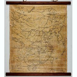
Railway map of China.
Railway map of China. Key in the left with keys to capital cities, Ocean cables, etc. Published by The Chinese Government Bureau of Economic Information, which was a nonp...
- $350 / ≈ €305
Date: China, ca. 1928
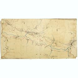
Carte du massif montagneux de Kuling (Province de Kiand-Si).
Manuscript map of the Kuling mountain range, showing the YangTze River, Lake Poyang, villages, etc. in French. Signed J.Volaz (?).Guling (or Kuling), is a resort town in ...
- $1500 / ≈ €1309
Date: China ?, ca.1930

A Map and History of Peiping; formerly known as Peking; capital of provinces, princedoms and kingdoms since 1121 B.C. . .
The uncommon second edition of this very decorative and informative pictorial map of Beijing and surrounding areas whimsically illustrates the Forbidden City, essential e...
Date: The Peiyang Press, Ltd. Tientsin-Peiping, 1936
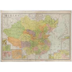
New China Map.
Very large and detailed map of China (1:6,000,000) printed in Shanghai, June 27th 1938 by JIN-SHIN GEOGRAPHICAL INSTITUTE.The title and place names in Chinese and Engli...
- $900 / ≈ €785
Date: Shanghai, June 27th 1938

China Southeast Coast.
A very large US Army and Naval map of the south east coast of China, published during the second world war. Map extent is from Kweichow Province in the west, to Kwangsi P...
- $1250 / ≈ €1091
Date: [New York], 1944
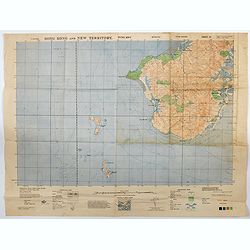
Hong Kong and New Territory - Tung Kwu.
A third edition air survey map of this portion of Lantau Island, to the west of Hong Kong, performed by the RAF. Originally published in 1931, then with minor corrections...
- $300 / ≈ €262
Date: London, 1945
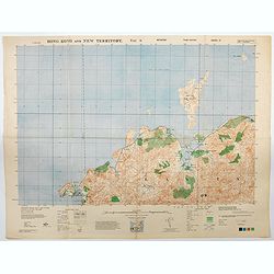
Hong Kong and New Territory - Tai O.
A third edition air survey map of this mainland portion of north west Hong Kong and New Territory, performed by the RAF. Originally published in 1931, then with minor cor...
- $400 / ≈ €349
Date: London, 1945

Key Map of Hong Kong Relative to Canton and Macao.
A nice folded map of Hong Kong and the surrounding areas. Produced by the British Crown Lands Survey Office just after WWII. Physical features are shown by contour. Railw...
Date: Hong Kong, 1948
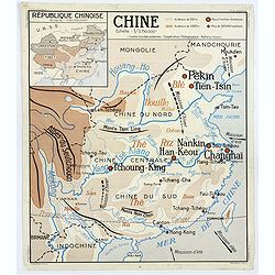
Chine - Angleterre.
A large, vintage French school poster map from the 1950s, showing China on one side and the United Kingdom on the reverse. As you would expect content and detail and basi...
Date: Nalliers, ca 1955
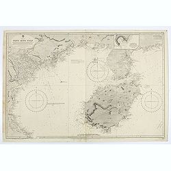
China sea. Tong King Gulf Compiled from the latest British and Foreign Government surveys to 1886. . .
Detailed Map of Chart of Annam Gulf or Tong King Gulf, in the China Sea. Chart with legend and scale. British Admiralty chart No. 2062, published June 1881, large correct...
- $400 / ≈ €349
Date: London, 1881 updated to 1957
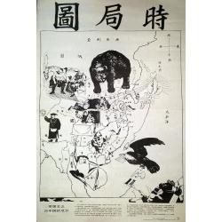
The Situation in the Far East. (時局圖)
An unusual rendering of Tse's "Situation in the Far East". Tse Tsan-tai (1872-1939), a Chinese patriot, drew the original political cartoon in Hong Kong in 1899...
Date: China, n.d. but ca. 1980/1990
