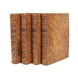
Description geographique, historique, chronologique, politique, et physique de l'empire de la Chine et de la Tartarie chinoise.
First edition of this cornerstone of any collection of books on China, which is also among the rarest and most desirable of important Americana, included in Rare American...
Date: Paris, P. G. Le Mercier, 1735
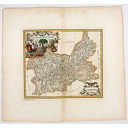
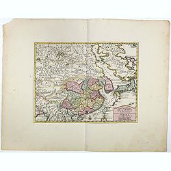
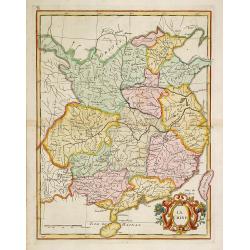
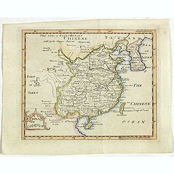
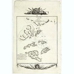
Province de Koei-Tcheou.
An important map of Koei-tcheou 贵州 [Guizhou]. With a quite elaborately pictorial cartouche featuring a rococo chinoiserie ornamentation engraved by Guélard, the map ...
- $100 / ≈ €86
Date: Paris, P.G. Le Mercier, 1735
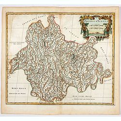
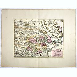
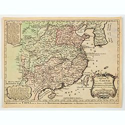
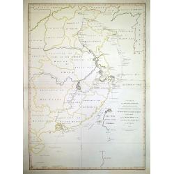
Province d'Yun-Nan.
Important map of Yun-nan 云南 [Yunnan] province. With a quite elaborately pictorial cartouche featuring a rococo chinoiserie ornamentation, engraved by Delahaye. Jean B...
- $100 / ≈ €86
Date: Paris, P.G. Le Mercier, 1735
Description geographique, historique, chronologique, politique, et physique de l'empire de la Chine et de la Tartarie chinoise.
Cornerstone of any collection of books on China, which is also among the rarest and most desirable of important Americana.This, "the first definitive European work o...
Date: Paris, P. G. Le Mercier, (vol. 1-3) 1770 / (vol.4),1735
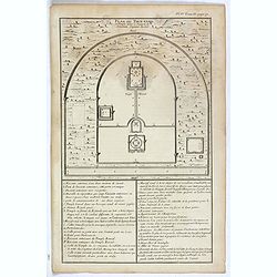
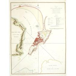
Plan du Tien-tang ou du temple, où l'empereur sacrifie à Chang-ti sous le titre de souverain seigneur de la terre.
Nice example of d'Anville's plan of Tien-tang temple, from "Atlas général de la Chine..."" prepared by Jesuit missionaries and commissioned by Emperor Ka...
Date: Paris, P.G. Le Mercier, 1735

Description geographique, historique, chronologique, politique, et physique de l'empire de la Chine et de la Tartarie chinoise . . . du Thibet, & de la Coree. . .
Without the separately published atlas. Lacking 2 plates in vol.2 (Obseques at p.149 and Gin seng at p.180), one plate torn without a loss (vol.1, p.230), d4 vol.1 with a...
Date: The Hague, H. Scheurleer, 1736
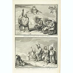
Charlatans qui se mêlent de vendre le vent de la Chine. Dévots mendiants de la Chine et charlatans qui se promènent sur des tigres apprivoisés, . . .
Two fascinating engraving on one sheet depicting Chinese charlatans. Engraved by Bernard Picart. Published in Jean Frederic Bernard's monumental "Cérémonies et cou...
- $150 / ≈ €130
Date: Amsterdam, J.F. Bernard c.1736
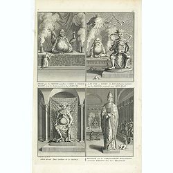
Idole que les chinois appellant, le dieu de l´immortalité, et qu´ils disent presider a leur Fortune. . .
Four fascinating engraving on one sheet depicting Chinese gods. "Idole que les chinois appellant, le dieu de l´immortalité, et qu´ils disent presider a leur Fortu...
- $150 / ≈ €130
Date: Amsterdam, J.F. Bernard c.1736

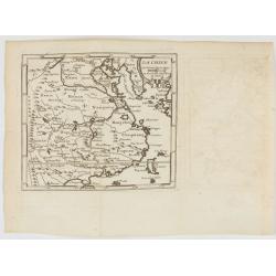
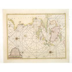
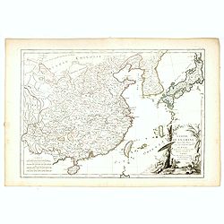
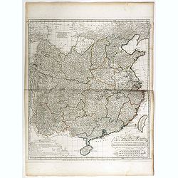
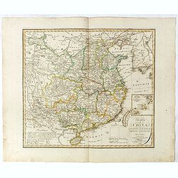
Carte la plus generale et qui comprend la Chine, la Tartarie chinoise et le Thibet. . .
It has a quite elaborate pictorial cartouche engraved by G. Kondet. It is a very detailed map of China, Tibet, and Korea.In the upper left corner is very good details of ...
Date: The Hague, 1737
Carte générale de la Chine Dressée sur les Cartes particulières que l'Empereur Cang-hi a fait lever sur les lieux par les RR. PP. Jésuites missionaires dans cet empire / Par le Sr d'Anville.
An essential and very detailed map of the Southern part of China, including a detailed map of Taiwan.Jean Baptiste Bourguignon d' Anville (1697-1782) was a French cartogr...
Date: The Hague, H. Scheurleer, 1737
![Province de Fo-Kien. [Includes West Coast of Taiwan]](/uploads/cache/43503-250x250.jpg)
Province de Fo-Kien. [Includes West Coast of Taiwan]
An important map of Fujian Province shows the East Coast of China and the West Coast of Taiwan. It shows that for the Manchu Qing, only the western half of Formosa was co...
Date: The Hague, H. Scheurleer, 1737

Nouvel atlas de la Chine, de la Tartarie chinoise, et du Thibet.
First edition of "the principal cartographic authority on China during the 18th century". It was the second major atlas of China produced in Europe following th...
Date: The Hague, H. Scheurleer, 1737
La Chine.
A very nice map of China, including Korea and Taiwan. From Francisco Giustiniani for El Atlas abreviado o el nuevo compendio de la Geografia universal, politica, historic...
- $300 / ≈ €259
Date: Leon de Francia (Lyon), Jaime Certa, 1739
![Carte de la coste orientale de la Chine depuis Amoy, jusqu'à Chusan avec une partie de l'Isle Formose [with] Plan du port d'Amoy ou Emouy.](/uploads/cache/33583-250x250.jpg)
Carte de la coste orientale de la Chine depuis Amoy, jusqu'à Chusan avec une partie de l'Isle Formose [with] Plan du port d'Amoy ou Emouy.
Important French chart of the China Sea with the coast of Northern China, including a large depiction of Formosa.Latitude and longitude scales, compass rose and system of...
Date: Paris, Jean-François Robustel, 1745
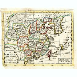
Het Keizerryk van China, volgens de Nieuwste Waarneminge opgesteld.
A scarce and uncommon miniature map of China, Korea and Taiwan. The map is of interest for the use of De Zuid Zee for the sea between Korea and Japan.
- $300 / ≈ €259
Date: Amsterdam, 1745

A view of the town and castle of Macao.
A nice engraving that shows the attack of the English ship "Centurion" on Macau, during which she captured a Portuguese ship that had sailed from Manila. In up...
Date: London, 1746
Das Kaiserthum China zur allgemeinen Historie der Reisen - entworfen von N. Bellin Ing. De la Mar. 1748.
Attractive and detailed map of China and Korea. The map is of interest for the use of Das Meer von Korea for the coast along the east coast of Korea. The composition is n...
- $500 / ≈ €432
Date: Leipzig, Arkstee & Merkus, 1746
Tabula chronologica historiae Sinicae connexa cum cyclo qui vulgo Kia Tse dictur.
A set of two sheets of colored copper engravings. First published in 1729 in Rome in three sheets. Timeline of China's history with a chronological overview of the dynast...
Date: Augsburg, 1746
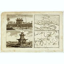
Chinese Temples. Sin-Ko-Tsyen. Canton, Sancian Isle. Ma-Kao.
An attractive print divided into four areas, two depicting Chinese temples and the other two with maps of the city of Canton, the island of Sancian and the island of Ma-K...
- $75 / ≈ €65
Date: London, 1745-1747
L'Empire de la Chine.
A fine map of China, Korea and Taiwan.Jacques Nicholas Bellin (1703-1772) was one of the most important and proficient French cartographers of the mid-eighteenth century....
- $450 / ≈ €389
Date: Paris, 1748
L'Empire de la Chine. . .
A fine map of China, Korea and Taiwan.Jacques Nicholas Bellin (1703-1772) was one of the most important and proficient French cartographers of the mid-eighteenth century....
- $450 / ≈ €389
Date: Paris, 1748
Empire de la Chine Par le Sr. Robert de Vaugondy fils de Mr. Robert Geog. Ord du Roi avec Privilege 1749.
Small detailed map of China, and Corea, including Taiwan. From Atlas Portatif Universel, by Robert de Vaugondy.Page 165 outside border top right. First and only state.The...
Date: Paris, 1749
![Kantong [The Dutch Folly Fort off Canton]](/uploads/cache/05714-250x250.jpg)
Kantong [The Dutch Folly Fort off Canton]
Charming 18th water color on paper depicting The Dutch "Folly Fort" off Canton. Probably made by a western artist visiting China.Forts were built in several pla...
Date: Canton?, c.1750

Kancheu.
Charming 18th water color on paper depicting Kancheu. Probably made by a western artist visiting China.
Date: c.1750
Nouvelle Carte de L'Empire De La Chine et les Pais circonvoisins - Nieuwe Kaart van t Keizerryk China en de aangrensende Landen.
Finely engraved map of China and Korea, with titles in both French and Dutch.The map extends west to the Gobi Desert and Tibet and shows Macao and Canton, among other cit...
- $500 / ≈ €432
Date: Amsterdam, 1750
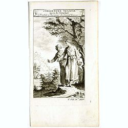
1. Seigneure Delassa tirés de Grueber. 2. Trophée à l'honneur du Grand Lama. (Tibet).
Fanciful European depiction of people from Tibet and Lhassa. A somewhat larger image appeared in "Abbe A.F. Prévost, Histoire Generale des Voyages".
Date: Paris, ca. 1750
Nouvelle Carte de L'Empire De La Chine et les Pais circonvoisins - Nieuwe Kaart van t Keizerryk China en de aangrensende Landen.
Finely engraved map of China and Korea, with titles in both French and Dutch.The map extends west to the Gobi Desert and Tibet and shows Macao and Canton, among other cit...
Date: Amsterdam, 1750
![[Lot of 13 prints of the Chinese court] Habillement de l' Empereur dela Chine & des Dames de son Palais aves quel...](/uploads/cache/IMG_0845-250x250.jpg)
[Lot of 13 prints of the Chinese court] Habillement de l' Empereur dela Chine & des Dames de son Palais aves quel...
Prints of the Chinese court.[Lot of 13 prints]- Salle Imperiale De L'Audience, tiree de Nieuhof (1760)- Pagodes ou Statues; Miniso ou la Volupté (1749- Pagodes ou sta...
- $400 / ≈ €346
Date: Amsterdam, c. 1750
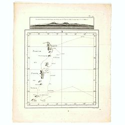
Paskaart van de Eijlanden Cheuxan Lowang en alle deselfs onderhoorige Eylande. . .
A rare and finely engraved and detailed chart of China's Zhejiang Province, including Ningbo, Zhoushan and Mount Putuo (Powto) and the mouth of the Yangtze Delta, just so...
Date: Amsterdam, 1753
![[Lot of 6] Carte de la Baye d'Hocsieu. Fukin. (3 Maps + 3 Gravure of China)](/uploads/cache/IMG_2524-250x250.jpg)
[Lot of 6] Carte de la Baye d'Hocsieu. Fukin. (3 Maps + 3 Gravure of China)
[Lot of 6 items]. (3 Maps +3 gravure )- Carte de la Baye d'Hocsieu et des Entrees de la Riviere de Chang Situees dans la Province de Fokyen. J.N.Berlin 1748- Carte de l�...
Date: Amsterdam, 1759

A new & accurate map of the Empire of China from the Sieur Robert's Atlas. With improvements.
An excellent early engraving of China and Korea that appeared in Sieur Robert de Vaugondy's Geographical Dictionary (London: 1759). Decorative title cartouche on the uppe...
Date: London, 1759
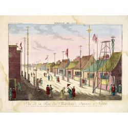
Vue de la Rue des Marchands Chinoises a Nankin.
So-called optical print illustrating a parade of vessels. Engraved by F.X. Habermann (1721-1796). The Academie Imperiale was a well-known publisher of optical prints, est...
- $450 / ≈ €389
Date: Augsburg, 1760
Vue d'une Rue Nanking.
A well-known publisher of optical prints, established in Augsburg. After a design by P.van Blankaert.In the eighteenth and nineteenth centuries, there were many popular s...
Date: Augsburg 1760
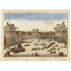
Le dedans du Palais de l'Empereur de Chine à Peking.
This so called optical print shows the imperial palace, the Forbidden City in Peking, China. In the foreground a large courtyard is depicted, surrounded by buildings. Thr...
Date: Augsburg, 1760

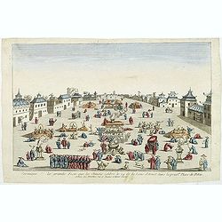
Vue perspective de la grande Ceremonie du Couronnement de l'Empereur de la Chine.
So-called optical print illustrating the crowning of the Chinese emperor. It shows the throne at the center.Mondhare was a well-known publisher of optical prints, establi...
Date: Paris, 1761
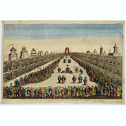
Vue perspective de la grande Ceremonie du Couronnement de l'Empereur de la Chine.
So-called optical print illustrating the crowning of the Chinese emperor. It shows the throne at the center.Mondhare was a well-known publisher of optical prints, establi...
- $450 / ≈ €389
Date: Paris, 1761
La Chine.
With decorative title cartouche lower right. Good detail of China's mainland with Taiwan and Hainan Province.
- $300 / ≈ €259
Date: Paris, 1767
![Plans de Quelques Villes de la Province de Hou-Quang. / Grondtekening [floor plan] van eenige Steden van't Landschap Hu-Quang.](/uploads/cache/34078-250x250.jpg)
Plans de Quelques Villes de la Province de Hou-Quang. / Grondtekening [floor plan] van eenige Steden van't Landschap Hu-Quang.
Interesting set of three local town plans each with extensive titles :"Yong Chew Fu, ou Yong Tcheou Fou." Centre: "Vu Chang Fu, ou Vou-Tchang-Fou Capitale:...
Date: The Hague, Pieter de Hondt, 1747-1767
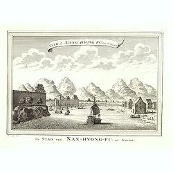
Cité de Nang Hyong Fu, tiree the Nieuhof. De Stad van Nan-Hyong-Fu, uit Nieuhof.
Interesting view of Nan-Hyong-Fu with harbour and fort.Prepared by Jacques Nicolas Bellin and included in a Dutch edition of Prévost d' Exile's "Histoire des Voyage...
Date: The Hague, Pieter de Hondt, 1747-1767
L'Empire de La Chine../ 't Keizerryk van China..
An attractive map of China with Korea and Taiwan (I.Tay-wan, ou Formosa) and "Mer de Coree'. There are decorative title cartouches in three corners of the map. The u...
- $200 / ≈ €173
Date: The Hague, 1773

A chart of the China Sea inscribed to Monsr. D'APRES de MANNEVILLETTE .. To A.Dalrymple.
This most important milestone chart is based upon the surveys made from navigational surveys by Alexander Dalrymple (1737-1808]. He was the first hydrographer of the Brit...
Date: Paris, ca 1775
A chart of the China Sea inscribed to Monsr. D'APRES de MANNEVILLETTE .. To A.Dalrymple.
Most important milestone sea chart is based upon the surveys made from navigational surveys by Alexander Dalrymple (1737-1808]. He was the first Hydrographer of the Briti...
Date: Paris, ca. 1775
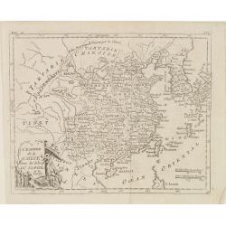
China.
A nice mid-eighteenth-century map of China, extending from the island of Hainan in the south, to the Kobi Desert in the north, from Lake Puka in Tibet in the west to Kore...
- $150 / ≈ €130
Date: Edinburgh, 1778
Ceremonie de la grande Feste que les Chinois celebre le 24 de la Lune d'Aoust dans la principale Place de Pekin.
So-called optical print illustrating the festivities on the 24th of August in Beijing.Mondhare was a well-known publisher of optical prints, established in Paris, at rue ...
Date: Paris, c.1780
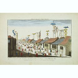
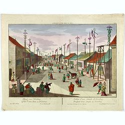
Vue perspective de la grande Rue de Nanquin ancienne Ville de la Chine.
So-called optical print of a street in Nanking. The wide boulevard is lined with merchants displaying their wares with colorful flags and signs. The street is filled with...
Date: Paris, c.1780
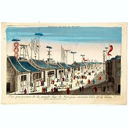
Vue perspective de la grande Rue de Nanquin ancienne Ville de la Chine.
So-called optical print of a street in Nanking. The wide boulevard is lined with merchants displaying their wares with colorful flags and signs. The street is filled with...
Date: Paris, c.1780
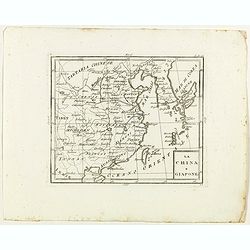
La China e Giapone.
Rare map of China, Korea and Japan, from "Atlante Novissimo ad uso Dei Giovani Studiosi Contenuto In Carte XXVII.", published by Giovanni Zempel in Rome, ca. 17...
- $300 / ≈ €259
Date: Rome, 1780
Plan du Typa, ou de Macao.
A pleasant copper engraving of Typa, Macao. By Rigobert Bonne from his ATLAS ENCYCLOPEDIQUE published in 1780. Engraved by Andre.Rigobert Bonne (1727-1795) was one of the...
- $100 / ≈ €86
Date: Paris, 1780
Vue de la Côte du Japon lorsque nous la vimespour la 1ere fois La Coline A restant dans l'O à 3 Millerc.
A pleasant copper engraving of Japan coasts. By Rigobert Bonne from his ATLAS ENCYCLOPEDIQUE published in 1780. Engraved by Andre.Rigobert Bonne (1727-1795) was one of th...
- $100 / ≈ €86
Date: Paris, 1780
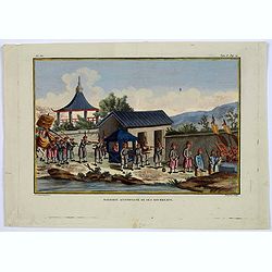
Mandarin accompagne de ses Bourreaux.
A copperplate taken from volume 2 of the work by Sonnerat titled: 'Voyage aux Indies Orientales et a Chine, fait par ordre du Roi, depuis 1774-1781…'.This colored coppe...
- $125 / ≈ €108
Date: Paris, ca. 1782
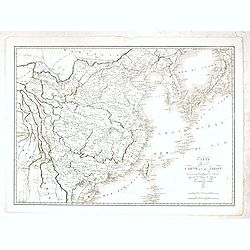
L'Empire de la Chine d'après l'Atlas Chinois, avec les Isles du Japon..
Attractive map of eastern part of China, including Taiwan, Korea and Japan. With ornamental title cartouche. Boundaries outlined in hand color.From theAtlas moderne ou co...
- $300 / ≈ €259
Date: Paris, ca 1783
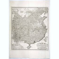
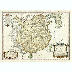
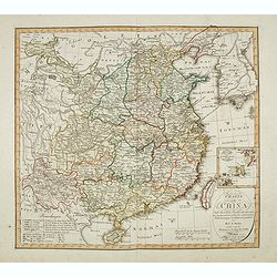
Carte Generale de la Chine Dressée sur les Cartes Particulieres Que l' Empereur Chang-Hi a fait lever sur les lieux..
Large map showing the traditional limits of China, including Hainan and Formosa in the South, and Quantong and parts of the Gobi Desert in the North.As the title notes, t...
Date: Paris, Ph.-D. Pierres, Clousier [- Moutard], 1785
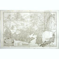
Carte Generale De La Tartarie Chinoise Dressee sur les Cartes Particulieres Faits Sur Les Lieux Par Les R.R. P.P. Jesuites . . . .MDCCXXXII
This is a very detailed map of the region from Japan to the Gobi Desert, centered on Mongolia and Korea, from D'Anville's Atlas of China. Jean Baptiste Bourguignon d' Anv...
Date: Paris, Ph.-D. Pierres, Clousier [- Moutard], 1785
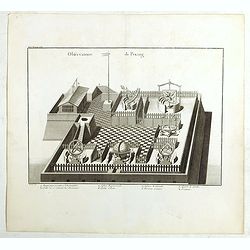
Observatoire de Peking.
The observatory of Mateo Rizzi in Peking, in which there are very large instruments, an Equinoctial Sphere, a Celestial Globe, a Zodiacal Sphere, Azimuthal Horizona, Quad...
Date: Paris, GROSIER Jean-Baptiste, 1785
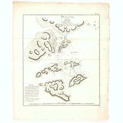
Sketch of the Typa and Macao.
A map of the environs of the Portuguese settlement of Macao in the Far East. The map shows a small town plan of Macao, nearby rocks, shoals depth soundings, and a few nav...
- $150 / ≈ €130
Date: London, 1785
A Plan of the city and harbour of Macao : a colony of the Portugueze, situated at the southern extremity of the Chinese Empire. . .
A large chart of Macao engraved by Benjamin Baker (fl. 1766-1824) and published by George Nicol. The town of Macao is shown in detail, with a 37-point key in English list...
Date: London, 1796
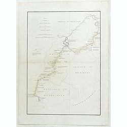
Sketch of A Journey from Hang-Tchoo-Foo To Quang-Tchoo-Foo or Canton in China.
A detailed map taken from, from Staunton's 'An Authentic Account of an Embassy from the King of Great Britain to the Emperor of China'.The map shows the second part of Ma...
Date: London, 1796
A Chart, on Mercator's Projection, Containing the Track and Soundings of the Lion, the Hindostan and Tenders, from Turon-Bay in Cochin-China. . .
A chart engraved by Baker and published by Nichol, this large chart traces the routes of the Lion, Hindostan, and Tenders with considerable detail. The chart was part of ...
Date: London, 1796
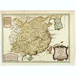
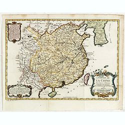
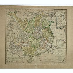
Carte Generale de la Chine Dressée sur les Cartes Particulieres Que l' Empereur Chang-Hi a fait lever sur les lieux. . . .
With a quite elaborately pictorial cartouche, engraved by the master engraver Guillaume-Nicolas de la Haye (1727 -1802). Large map showing the traditional limits of China...
- $750 / ≈ €648
Date: Paris, Dezauche, 1789–1799
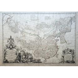
Carte la plus generale et qui comprend la Chine, la Tartarie chinoise et le Thibet. . .
With a quite elaborately pictorial cartouche, engraved by G.Kondet. Very detailed map of China, Tibet and Korea. Jean Baptiste Bourguignon d' Anville (1697-1782), French ...
- $2700 / ≈ €2334
Date: Paris, Dezauche, 1789–1799

Reis-kaart van het Britsche gezantschap van Hang-choe-foe naar Quang-choe-foe of Kanton in China.
Uncommon map of eastern part of China, showing a journey of the English Embassy from Hangzhou (south of Shanghai) to Guangzhou (Canton). The maps is giving a wealth of in...
Date: Netherlands, c.1800

La China e Giapone.
Uncommon map of China, Korea, Japan and Taiwan (I.Formosa), only one town labeled, Tayoan. Very strange shape for Japan.The map is of interest for the use of Mar di Corea...
Date: Italy, ca. 1800
Charte von China nach Murdochischer Projection entworfen. ... Berichtiget, und gezeichnet von H.F.A. Stieler. . .
Uncommon map of China prepared by H.F.A.Stieler, with parts of Taiwan, Tibet, Mongolia and the Korean peninsula, with a great many place names, a key to (and brief explan...
Date: Weimar, 1804
Charte von China nach Murdochischer Projection entworfen. ... Berichtiget, und gezeichnet von H.F.A. Stieler. . .
Uncommon map of China prepared by H.F.A.Stieler, with parts of Taiwan, Tibet, Mongolia and the Korean peninsula, with a great many place names, a key to (and brief explan...
- $600 / ≈ €519
Date: Weimar, 1804
![Morokoshi Meisho Zue [Illustrated Description of Famous Sites of China].](/uploads/cache/34118-250x250.jpg)
Morokoshi Meisho Zue [Illustrated Description of Famous Sites of China].
Published in Osaka, Kawachiya Genhichiro, et al. [8 book sellers], slightly later issue but apparently in Edo period, using all the same woodblocks of original first edit...
Date: Osaka, Edo, slightly later than Bunka 3, year of the tiger - 1806
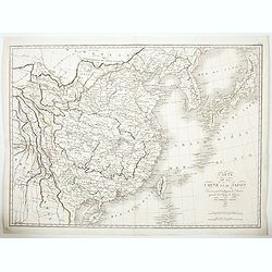
L'Empire de la Chine, avec les Isles du Japon, et la Corée.
Map of south eastern China, including Taiwan, Korea and Japan. From Atlas de la Géographie de toutes les parties du monde .. Ouvrage destiné pour l'education, et néces...
Date: Paris, Prudhomme, Levrault, Debray, 1806
![[assorted Chinese musical instruments].](/uploads/cache/37968-250x250.jpg)
[assorted Chinese musical instruments].
A delightful copperplate print of 15 assorted Chinese musical instruments including gong, bell, drum, cymbals etc.
- $35 / ≈ €30
Date: Germany, ca. 1812
![[assorted Chinese musical instruments].](/uploads/cache/37969-250x250.jpg)
[assorted Chinese musical instruments].
A delightful copperplate print of 15 assorted Chinese musical instruments including violin, flute, trumpet, guitars, cymbals etc.
- $30 / ≈ €26
Date: Germany, ca. 1812
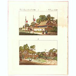
Verm Gegenstaende. CXIII. 1 Melandes CCXIII.
A Chinese Mandarin house and below a Chinese village scene with farmers.
- $50 / ≈ €43
Date: Germany, 1812
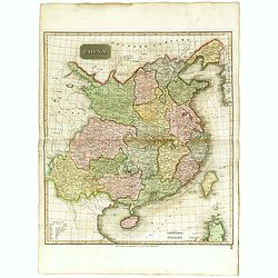
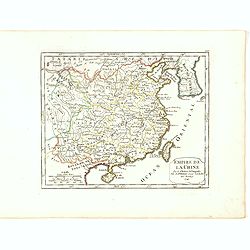
China.
Highly detailed map of China including Formosa (Taiwan), Hainan, and part of Luzon in the Philippines. The map show the Tract of the Hindoostan and Lion with the British ...
Date: Edinburgh, 1815
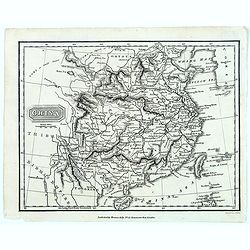
China.
From the atlas the 'Universal Geography' by Thos. Kelly, and engraved by Finlay. This copper plate maps shows the mainland of China, together with the islands of Formosa ...
Date: London, ca. 1817

Chungguk-do
Chungguk-do [Map of China] taken from a Korean printed Ch’onha chido [Atlas of all under Heaven] which is a 19th century version of the traditional Korean atlas produce...
Date: Korea, ca. 1820
Charte von China nach Murdochischer Projection entworfen. ... Berichtiget, und gezeichnet von H.F.A. Stieler. . .
Uncommon map of China prepared by H.F.A.Stieler, with parts of Taiwan, Tibet, Mongolia and the Korean peninsula, with a great many place names, a key to (and brief explan...
Date: Augsburg, 1820
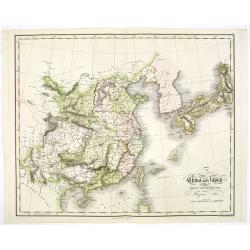
Carte de la Chine et du Japon. Dressée pour l'intelligence de l'histoire général des voyages de Laharpe. . .
Engraved by Tardieu for L'Intelligence de l'histoire generale des Voyages de Laharpe .Rare and detailed map of China, Korea, Japan and Taiwan (I.Formose ou Pekan).
Date: Paris, 1821
Carte de la Chine et du Japon..
Engraved by Tardieu for L'Intelligence de l'histoire generale des Voyages de Laharpe .Rare and detailed map of China, Korea, Japan and Taiwan (I.Formose ou Pekan).
- $100 / ≈ €86
Date: Paris, 1821
China and Japan drawn and engraved for Dr. Playfairs Atlas.
Detailed map of China, Korea, Japan and Taiwan engraved by H. Cooper and published by Alexander Macredie. Originally engraved for James Playfair's " A New General At...
- $700 / ≈ €605
Date: Edinburgh, 1824
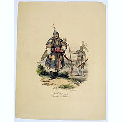
Garde Imperiale. Cavalier et Fantassin.
A decorative, colored lithograph of a Guard in the Chinese Imperial Army, and that of a Cavalier. From the work by Malpiere titled: " La Chine, Moeurs, Usages, Arts ...
- $50 / ≈ €43
Date: Paris, ca. 1825

Partie de la Chine. N°.74 (Including South Korea)
Covering the Mouth of the Yangtze area in Jiangsu and Zhejiang, and southwestern Korea with the island of Quelpart (Jeju-do). Shows explorers' routes, including La Perou...
Date: Brussels, 1825-1827

Partie de la Chine N°87. (Covers Jiangxi, Fujian and parts of Zhejiang, Guangdong, Hunan and Hubei.)
Covers Jiangxi, Fujian and parts of Zhejiang, Guangdong, Hunan and Hubei.From his famous Atlas Universel . This atlas was one of the most remarkable world atlases ever pr...
Date: Brussels, 1825-1827

Partie de la Chine N°86. (Covers Guizhou and parts of Yunnan, Guangxi, Hunan, Hubei and Sichuan.)
Covers Guizhou and parts of Yunnan, Guangxi, Hunan, Hubei and Sichuan.From his famous Atlas Universel . This atlas was one of the most remarkable world atlases ever produ...
Date: Brussels, 1825-1827
