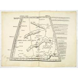
Octava Asie Tabula.
PTOLEMY, C. / WALDSEEMÜLLER, M. - The Silk Road Area.
Date: Strasburg, 1513

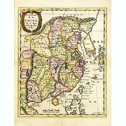
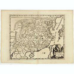
Tabula Superioris Indiae & Tartariae maioris. (Modern Map of China, Japan, etc.)
Important map extending from Tartary in the north, to "Prov. Bocat" (Cambodia) in the south. "Tebet" is shown prominently, as is "Zinpangri"...
Date: Vienne, 1541
![[India and China]](/uploads/cache/33875-250x250.jpg)
[India and China]
Wood block printed map and one of earliest printed representation of India and China prepared Martin Waldseemüller. Based on the slightly larger map from 1513 published ...
Date: Vienna, 1525 -1541
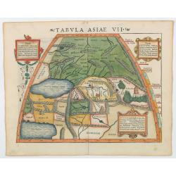
Tabula Asiae VII.
Attractive woodblock map, depicting the Caspian Sea, Black Sea and the Persian Gulf, extending to the Imaus Mountains. according to Ptolemy. In the center of the map is...
- $500 / ≈ €439
Date: Basle, 1542
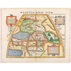
Tabula Asiae VII.
Attractive woodblock map, depicting the Caspian Sea, Black Sea and the Persian Gulf, extending to the Imaus Mountains, according to Ptolemy. In the center of the map is ...
Date: Basle, 1542

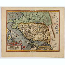
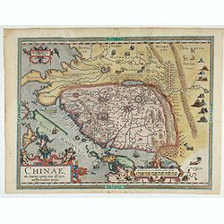
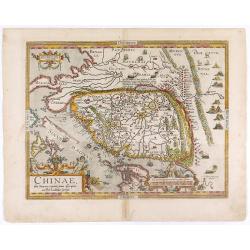
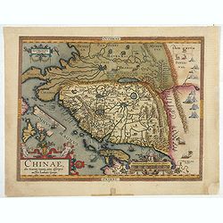
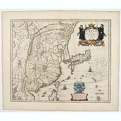
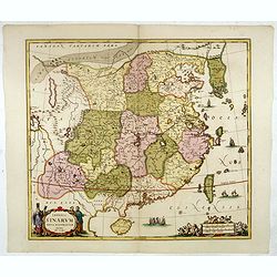
Chinae, olim Sinarum Regionis, nova descriptio. Auctore Ludovico Georgio.
The first map of China ever to appear in a Western atlas, west to the top. The first state without "las Philiooinas" somewhere in 1587 added to the plate. When ...
Date: Antwerp, 1584
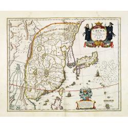
Chinae, olim Sinarum Regionis, nova descriptio. Auctore Ludovico Georgio.
The first map of China ever to appear in a Western atlas, west to the top. The second state with "Las Philipinas" somewhere in 1587 added to the plate. When thi...
- $6000 / ≈ €5265
Date: Antwerp, 1592
Chinae, olim Sinarum regionis. . .
The first printed map of China. It is signed by Ludovico Georgio, whose real name was Luis Jorge de Barbuda. He was a Portuguese Jesuit cartographer and besides that a sp...
Date: Antwerp, 1598

Chinae, olim Sinarum regionis. . .
The first printed map of China. It is signed by Ludovico Georgio, whose real name was Luis Jorge de Barbuda. He was a Portuguese Jesuit cartographer and besides that a sp...
Date: Antwerp, 1598
![[A Chinese vessel ] Naves Chinensibus usitatae velis arundineis & anchoris ligneis.](/uploads/cache/29498-250x250.jpg)
[A Chinese vessel ] Naves Chinensibus usitatae velis arundineis & anchoris ligneis.
Showing a Chinese vessel, print taken from Linschoten's famous voyages to the East of 1583-92, here published by De Bry the year after they first appeared as a separate b...
Date: Frankfurt, 1599
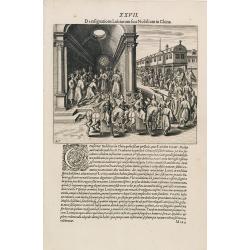
A Parade of Noblemen in China.
This famous and desirable scene from Linschoten's famous voyages to the East of 1583-92 is here published by De Bry the year after they first appeared as a separate book....
Date: Frankfurt, 1599
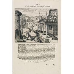
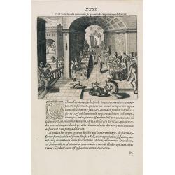
Punishment of China.
The Chinese way of a punishment from Linschoten's famous voyages to the East of 1583-92 here published by De Bry the year after they first appeared as a separate book. Fr...
Date: Frankfurt, 1599
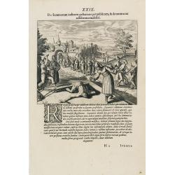
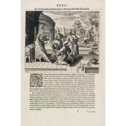
Punishment of a criminal in China.
Punishment of a criminal in China from Linschoten's famous voyages to the East of 1583-92, here published by De Bry the year after they first appeared as a separate book....
Date: Frankfurt, 1599
Feast of China.
A scene of a Chinese dinner feast from Linschoten's famous voyages to the East of 1583-92, here published by De Bry the year after they first appeared as a separate book....
Date: Frankfurt, 1599
Funeral in China.
A scene of a funeral in China from Linschoten's famous voyages to the East of 1583-92, here published by De Bry the year after they first appeared as a separate book. Fro...
Date: Frankfurt, 1599
Chinae, olim Sinarum regionis. . .
The first printed map of China. It is signed by Ludovico Georgio, whose real name was Luis Jorge de Barbuda. He was a Portuguese Jesuit cartographer and besides that a sp...
- $6000 / ≈ €5265
Date: Antwerp, 1608
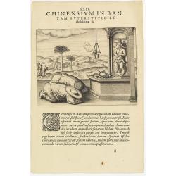
Chinensium in Bantam Superstitio et idololatria. 18. ( How the Chinese worship their idols in Bantam)
How the Chinese worship their idols in Bantam. As can be seen here, the Chinese worship their idol, which takes the form of a devil. They lay offerings of fruit on an alt...
- $100 / ≈ €88
Date: Frankfurt, 1609
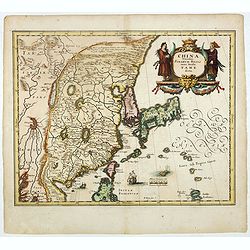
Chinae, olim Sinarum Regionis, nova descriptio. Auctore Ludovico Georgio.
The first map of China ever to appear in a Western atlas, west to the top. When this map appeared, it was by far the most accurate one of China.The map is based on a manu...
- $5500 / ≈ €4826
Date: Antwerp, 1608 /1612
De Christiana expeditione apud Sinas suscepta ab Societate Jesu, ex P. Matthaei Ricci.
Very rare first edition of the most influential Western description of China since the 13th-century account by Marco Polo. Printed in Latin with an engraved title page in...
Date: Augustæ Vind. (Augsburg), C. Mangium, 1615
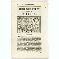
China.
Small map illustrating China with the Great Wall and Korea as an island, surrounded by text in Dutch.Nicolaes de Clerck (de Klerc) was active as engraver and publisher in...
- $200 / ≈ €176
Date: Amsterdam, Cloppenburch, 1621
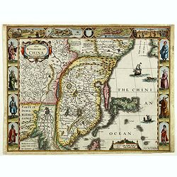
The Kingdome of China.
A most sought-after map of China. Decorative border vignettes including views of the cities of Quinzay and Macao along the top border with the wheeled wind machines and p...
Date: London, G. Humble, 1626

The Kingdome of China.
A most sought-after map of China. Decorative border vignettes including views of the cities of Quinzay and Macao along the top border with the wheeled wind machines and p...
Date: London, G. Humble, 1627
China Veteribus Sinarum Regio nunc Incolis Tame dicta.
Fine map of China, based on the first of Blaeu's maps of China. In the west by the Great Wall is shown, among Taiwan is named Pakan al I. Formosa, although Tayoan is name...
- $950 / ≈ €834
Date: Frankfurt am Main, 1638
Pecheli sive Peking imperii sinarum provincia prima.
The map of the province of Peking from Joan Blaeu's Novus Atlas Sinensis , the first atlas of China with maps by the hand of the Italian Jesuit Martino Martini. A beautif...
Date: Amsterdam, 1640

China Veteribus Sinarum Regio.
Based on Jesuit surveys, the map represents the next major revision in the cartography of China after Ortelius' 1584 map. Korea, however, is still an island, and Japan co...
Date: Amsterdam, 1640
China Veteribus Sinarum Regio.
This was the first of Blaeu's maps of China. In 1655 he was to publish the famous map of Father Martini, with many of the earlier inaccuracies present on this map correct...
- $2200 / ≈ €1931
Date: Amsterdam, 1644
China Veteribus Sinarum Regio.
This was the first of Blaeu's maps of China. In 1655 he was to publish the famous map of Father Martini, with many of the earlier inaccuracies present on this map correct...
Date: Amsterdam, 1653
Royaume de la Chine. . .
Detailed map of China. Engraved by A.Winter. Attractive miniature map, depicting Korea as an island and parts of Japan, i.e. western part of Honshu and Kyushu.
Date: Paris, 1656
La Chine Royaume. . .
An important and attractive French map of the whole of China, northern tip of the Philippines, with a strangely curved Korea and an under-sized Taiwan here called "Y...
Date: Paris, 1656
La Chine Royaume. . .
An important and attractive French map of the whole of China, the northern tip of the Philippines, with a strangely curved Korea and an under-sized Taiwan here called &qu...
- $2600 / ≈ €2282
Date: Paris, 1656
Quantung Imperii Sinarum Provincia duodecima.
A beautifully engraved map of Southern China covers Hainan, the Pearl River Delta, and Greater Hong Kong.A legend at left identifies cities and towns of various sizes, fo...
Date: Amsterdam, 1660

Xantung, sinarum imperii provincia quatra.
A map of the northern province ‘Xantung’ of China after the Jesuit Martino Martini. Shows the Great Wall and is centered on the Bohai Sea, and the Shandong and Liaon...
Date: Amsterdam, ca 1660
Imperii Sinarum nova descriptio.
Schenk and Valk's rare early 18th century issue of Janssonius milestone map of China, Korea and Japan after Martino Martini. Engraved by Johannes van Loon. The overall ba...
- $1600 / ≈ €1404
Date: Amsterdam, ca. 1660

Pecheli, Xansi, Xantung, Honan, Nanking, In plaga Regni Sinensis. . .
A map of the northern provinces of China after the Jesuit Martino Martini, depicting Hebei (Pecheli), Shanxi (Xansi), Shandong (Xantung), Henan (Honan), and Jiangsu (Nank...
Date: Amsterdam, ca 1660

Fokien Imperii Sinarum Provincia undecima.
The province of Fokien lies opposite Taiwan and south of the region described in the above map. The coast is shown from Wen-zhou in the north to Fu-zhou and as far south ...
Date: Amsterdam, 1660

Xantung, sinarum imperii provincia quatra.
A map of the northern province ‘Xantung’ of China after the Jesuit Martino Martini.Shows the Great Wall and is centered on the Bohai Sea, and the Shandong and Liaonin...
Date: Amsterdam, ca 1660

La Chine.
Rare map of China, Korea (as an island) and Japan, published by Jollain in 1667. In upper right corner part of North America. Published in "Trésor Des Cartes Geogra...
- $350 / ≈ €307
Date: Paris, 1667

An embassy from the East-India Company of the United Provinces, to the Grand Tartar Cham, Emperor of China deliver'd by their excellencies, Peter de Goyer and Jacob de Keyzer, at his imperial city of Peking. . .
Very rare first English text edition of this most important and early resource on China and the Chinese. Three parts in one folio by John Macock for the author.Part I: An...
Date: London : Printed by the Author at his house in White-Friers, 1669
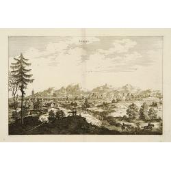
Peking.
Fine panoramic view of Peking. From Olfert Dapper mission to China, 1662-1663. Printed by Jacob van Meurs, title of the book: Gedenckwaerdig bedrijf der Nederlandsche Oos...
- $200 / ≈ €176
Date: Amsterdam, 1670

La Chine d'Athanase Kirchere de la compagnie de Jesus, illustrée de plusieurs monuments tant sacrés que profanes et de quantité de recherches de la nature. . .
Athanasius Kircher, S.J., (1601 or 1602-1680) was a 17th-century German Jesuit scholar who published around 40 works, most notably in the fields of oriental studies, geol...
Date: Amsterdam, 1670

Il regno della China detto presentente Catay e Magnin. . .
A rare and decorative Italian map of China and Japan, with Japan closely modelled on the indented Cardim outline and Hokkaido, called Yuppi , shown as an Asian peninsula....
Date: Rome, 1682
Royaume de la Chine. . .
Detailed map of China. Engraved by A.Winter. Attractive miniature map, depicting Korea as an island and parts of Japan, i.e. western part of Honshu and Kyushu.
- $450 / ≈ €395
Date: Utrecht, 1683
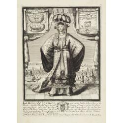
La Reine de la chine.
Very rare and decorative costume plate. In the background : Palais Royal Peking. Beneath the plate a descriptive text about the Queen of China.Bears the address : Se vend...
Date: Paris, ca. 1685

Paradigma XV Provinciarum et CLV Urbium Capitalium Sinensis Imperij Cum Templis quae Cruce X Signatur Et Domiciliis S.I.
First edition of this rare Jesuit map of China, published by Jean Baptiste Nolin in Paris and based on Philippe Couplet's map of 1686. The map shows China's 15 provinces ...
Date: Paris, 1686

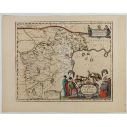
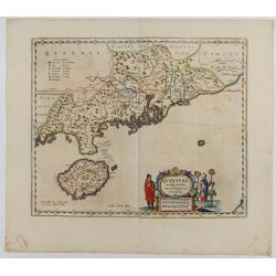
Iunan, Queichev, e Quangsi Provincie della Cina. . .
A beautiful map depicting the area of Beijing with decorative title cartouche and scale cartouche. Information about the area at the top of the map.The remarkable Vincenz...
Date: Venice, 1690

Quantung, e Fokien, Provincie della China...
A beautifully engraved decorative map of Southern China extending from Hainan in the West to Formosa in the East and centered on the Pearl River Delta with Macao and the ...
Date: Venice, 1691

Het gezandtschap der Neerlandtsche Oost-Indische Compagnie, aan den grooten Tartarischen Cham, Den tegenwoordigen Keizer van China. . .
Third edition of this beautifully illustrated work on China. The first edition was published in 1665.Jan Nieuhof was a "Dutch traveler and adventurer" (1618-72)...
Date: Amsterdam, W. Waasberge, 1693

Parte orientale della China.. / Parte occidentale della China. (2 sheets)
The map depicts the eastern part of China with Korea -correctly- as a peninsula. Formosa is included as well. Japan is partly visible i.e. the area of Yamaguchi, strait K...
Date: Venice, 1695
Imperii Sinarum Nova Descriptio.
Interesting map of China, shows the Great Wall, Macao and the Island of Formosa. From Philipp Clüver's famous Introductionis in Universam geographicam, first published i...
- $300 / ≈ €263
Date: Amsterdam, 1697
Xantung, e Peking provincie della china. . .
A beautiful map depicting the area of Beijing with decorative title cartouche and scale cartouche. Information about the area at the top of the map.To the right the west ...
- $350 / ≈ €307
Date: Venice, 1698

Collection of rubbings with portraits and biographies of famous Chinese philosophers, poets and legendary wise old men.
ca. 1701 - Stone rubbings of portraits and biographies of famous Chinese philosophers
- $15000 / ≈ €13163
Date: China or Korea, c. 1701
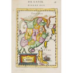
La Chine.
A charming small map of China, Taiwan, the Philippines, Korea, and Kyushu (Japan). By Allain Manesson Mallet (1630-1706), a well-traveled military engineer and geographer...
- $300 / ≈ €263
Date: Paris, 1720

Imperii Sinarum nova descriptio.
Schenk and Valk's rare early 18th century issue of Janssonius milestone map of China, Korea and Japan after Martino Martini. Engraved by Johannes van Loon. The overall ba...
Date: Amsterdam, ca. 1720
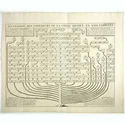
Succession Des Empereurs De la Chine divisée en XXII. Familles.
Showing successions of the Emperors of China divided into 22 families, copper engraved plate from "Atlas Historique". Zacharie Chatelain (d.1723) was the father...
- $100 / ≈ €88
Date: Amsterdam, 1720
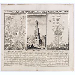
Description d'un des plus fameux temples des Chinois..
This impressive engraving is a wonderful example of Chatelain’s elegant plates.Divided in 3 panels, respectively showing the most important gods in the Chinese deities ...
Date: Amsterdam, ca. 1720

Huquang, Kiangsi, Chekiang ac Fokien.
A reissue of Janssonius' map of south east China, with wash color and uncolored cartouches.The map is based on the maps of Martin Martini, themselves based on Chinese sou...
Date: Amsterdam, 1720
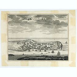
De Stad Macao.
A fine view of the city of Macao from Lappa Island showing the defenses, the forts, churches and convents: including Fort de Baare, Bon Parto, Fort St Paulo (Monte Fort)....
Date: Amsterdam, 1724
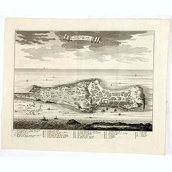
Platte Grond vande Stadt Macao.
A fine view of the city of Macao from Lappa Island showing in schematic blocks the structure of the town. With European vessels and junks in the surrounding water. With n...
Date: Amsterdam, 1724
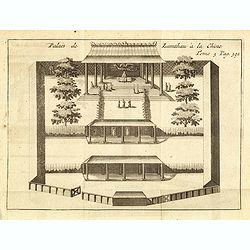
Palais de Lamthau à la Chine.
View of a Mandarin's Palace at Lantau Island, showing the palace wall, 3 gates and guards in the inner palace where the Mandarin meets with the officers.. Tome 3 Page 392...
- $75 / ≈ €66
Date: Amsterdam, J.F. Bernard, 1725
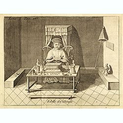
Idolle des Chinois.
Print of a Chinese divinity. Tome 3 Page 377 in upper left corner. From the French reissue of the account of early Dutch voyages first published in 1608 by Commelin. The ...
- $75 / ≈ €66
Date: Amsterdam, J.F. Bernard, 1725
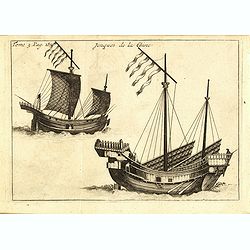
Jonques de la Chine.
A depiction of two Chinese junks. Tome 3 Page 377. From the French reissue of the account of early Dutch voyages first published in 1608 by Commelin. The French translati...
- $75 / ≈ €66
Date: Amsterdam, J.F. Bernard, 1725
La Chine suivant les nouvelles observations...
Uncommon edition of this map of China. From Le Nouveau Theatre du Monde, ou la Geographie Royale.Curious shape of South Korea.
- $1100 / ≈ €965
Date: Amsterdam, 1728

Habillement de l'Empereur de la Chine & des Dames de son Palais..
This impressive engraving is a wonderful example of Chatelain’s elegant plates.Divided in 3 panels, showing examples of costumes of Chinese ladies and those of the king...
Date: Amsterdam, ca. 1728

Hedendaegsche Historie of tegenwoordige staet van alle volkeren 1 deel. (Volume 1 - China, Japan, Phillippines, Moluccas)
This provides an interesting illustrated description of China, Japan, the Phillippines, Moluccas. Including a map of China, Korea, and Japan, with the Sea between Korea a...
Date: Amsterdam, 1734
![Province de Pe-Tche-Li. Pe-tche-li [Beizhili] 北直隶 [= 河北]. province.]](/uploads/cache/39689-250x250.jpg)
Province de Pe-Tche-Li. Pe-tche-li [Beizhili] 北直隶 [= 河北]. province.]
Important map of Pe-tche-li [Beizhili] 北直隶 [= 河北]. With a quite elaborately pictorial cartouche featuring a rococo chinoiserie ornamentation, engraved by Guéla...
- $300 / ≈ €263
Date: Paris, P.G. Le Mercier, 1735
Description geographique, historique, chronologique, politique, et physique de l'empire de la Chine et de la Tartarie chinoise.
First edition of this cornerstone of any collection of books on China, which is also among the rarest and most desirable of important Americana, included in Rare American...
Date: Paris, P. G. Le Mercier, 1735
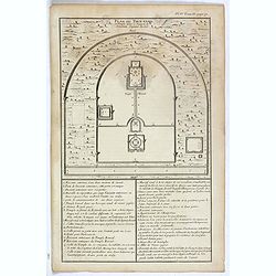
Plan du Tien-tang ou du temple, où l'empereur sacrifie à Chang-ti sous le titre de souverain seigneur de la terre.
Nice example of d'Anville's plan of Tien-tang temple, from "Atlas général de la Chine..."" prepared by Jesuit missionaries and commissioned by Emperor Ka...
Date: Paris, P.G. Le Mercier, 1735
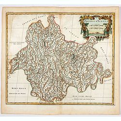
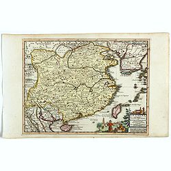
Province d'Yun-Nan.
Important map of Yun-nan 云南 [Yunnan] province. With a quite elaborately pictorial cartouche featuring a rococo chinoiserie ornamentation, engraved by Delahaye. Jean B...
- $100 / ≈ €88
Date: Paris, P.G. Le Mercier, 1735
![Province de Koei-Tcheou. [Koei-tcheou 贵州 [Guizhou] province.]](/uploads/cache/39688-250x250.jpg)
Province de Koei-Tcheou. [Koei-tcheou 贵州 [Guizhou] province.]
Important map of Koei-tcheou 贵州 [Guizhou]. With a quite elaborately pictorial cartouche featuring a rococo chinoiserie ornamentation, engraved by Guélard, the map by...
- $300 / ≈ €263
Date: Paris, P.G. Le Mercier, 1735
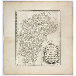
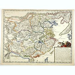
Province de Kiang-Si. Jiangxi 江西 province.
An important map of Jiangxi 江西 province. With a quite elaborately pictorial cartouche featuring a rococo chinoiserie ornamentation, engraved by Guélard. The map itse...
- $200 / ≈ €176
Date: Paris, P.G. Le Mercier, 1735
![Province de Ho-nan. [Honan 河南 (Hénán) province]](/uploads/cache/39696-250x250.jpg)
Province de Ho-nan. [Honan 河南 (Hénán) province]
An important map of Honan 河南 (Hénán) province. With a quite elaborately pictorial cartouche, engraved by F.Baillieul Lainé. Jean Baptiste Bourguignon d' Anville (1...
- $200 / ≈ €176
Date: Paris, P.G. Le Mercier, 1735
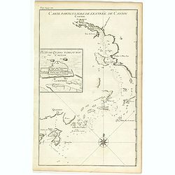
Carte particulière de l'entrée de Canton - Plan de Quang-tcheou-fou vulgo Canton .
Beautiful detailed map of the entrance to the city of Canton, showing also the cities of Macao and Quanghai, as well as the islands of the bay, including the island of Sh...
- $450 / ≈ €395
Date: Paris, P.G. Le Mercier, 1735
Province de Koei-Tcheou.
An important map of Koei-tcheou 贵州 [Guizhou]. With a quite elaborately pictorial cartouche featuring a rococo chinoiserie ornamentation engraved by Guélard, the map ...
- $100 / ≈ €88
Date: Paris, P.G. Le Mercier, 1735
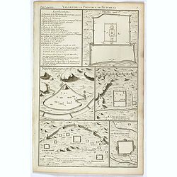
Villes de la province de Petche-li.
Five town plans : Peking (with forbidden town), Yung-ping-fou, Long-men-hien, Yuen-keou/Tching-sse-yu/Si-yang-keou/Hoang-tou-in, Tchin-ting-fou. From "Description ge...
- $150 / ≈ €132
Date: Paris, P.G. Le Mercier, 1735
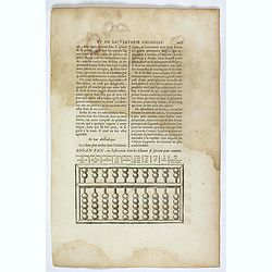
Souan pan, ou instrument dont les chinois se servent pour compter.
Text page with a wood block illustration of a souan-pan [suan-p'an] the calculation table used by the Chinese. Jean Baptiste Bourguignon d' Anville (1697-1782), French c...
Date: Paris, P.G. Le Mercier, 1735
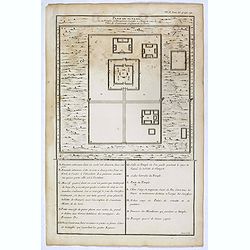
Plan du Ti-tang ou du temple, où l'empereur sacrifie à Chang-ti sous le titre de souverain seigneur de la terre
A plan of the temple of the soil god (社稷壇, Shèjìtán, "Altar of Soil and Grain")—under the name "Titang" (地堂, dìtáng, "Hall of Di...
Date: Paris, P.G. Le Mercier, 1735
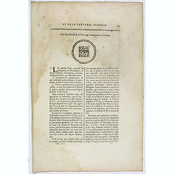
Carte du ciel et de la terre qui commencent à se former / Figure du ciel fluide & pur & de la terre fixe & ferme.
Recto and verso text page with two illustrations of the grounding of the sky and earth according to a Chinese philosopher. Jean Baptiste Bourguignon d' Anville (1697-178...
- $75 / ≈ €66
Date: Paris, P.G. Le Mercier, 1735
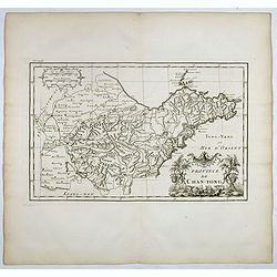
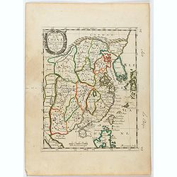
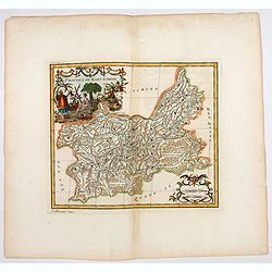
Province de Chan-Tong.
Detailed map of Shandong Province. With a quite elaborately pictorial cartouche, engraved by Guélard, the map by Delahaye, featuring a rabbit and rococo chinoiserie orna...
- $300 / ≈ €263
Date: Paris, P.G. Le Mercier, 1735
![Province de Tche Kiang. [Tche kiang 浙江 [Zhejiang] province]](/uploads/cache/39693-250x250.jpg)
Province de Tche Kiang. [Tche kiang 浙江 [Zhejiang] province]
D'Anville's highly detailed map of Tche kiang 浙江 [Zhejiang] province from du Halde's "Description geographique historique...de l'Empire de la Chine et de la Tart...
- $400 / ≈ €351
Date: Paris, P.G. Le Mercier, 1735
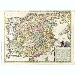
![Province de Hou-Quang. [Hou-quang 湖广 [Huguang] province.]](/uploads/cache/39694-250x250.jpg)
Province de Hou-Quang. [Hou-quang 湖广 [Huguang] province.]
Important map of Hou-quang 湖广 [Huguang] province. With a quite elaborately pictorial cartouche, engraved by Guélard, the map engraved by F.Baillieul Lainé, featurin...
- $250 / ≈ €219
Date: Paris, P.G. Le Mercier, 1735
