Browse Listings in Asia > Arabian Peninsular
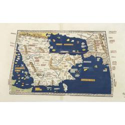
Tabula Sexta Asia (Arabian Peninsula)
This is a very desirable early Ptolemaic woodblock map of the Arabian Peninsula, here called Arabia Felix. The map is presented on a trapezoidal projection with paralle...
- $2200 / ≈ €2059
Place & Date: Strassburg, 1525

Tabula Sexta Asia (Arabian Peninsula)
This is a very desirable early Ptolemaic woodblock map of the Arabian Peninsula, here called Arabia Felix. The map is presented on a trapezoidal projection with par...
Place & Date: Vienna, 1525 -1541
![[Arabian Peninsula]](/uploads/cache/33869-250x250.jpg)
[Arabian Peninsula]
Wood block printed map and one of earliest printed representation of the Arabian Peninsula prepared by Martin Waldseemüller. Based on the slightly larger map from 1513 p...
- $2200 / ≈ €2059
Place & Date: Vienna, Trechsel, G., 1525 -1541

[Lot of 9 leaves with maps and views of Persia and Arabia).
Nineteen text leaves with wood block illustrations relating to Persia and Arabia. From the 1552 Latin text edition of Münster's Cosmographia, which is a short and comple...
- $100 / ≈ €94
Place & Date: Basel, 1552
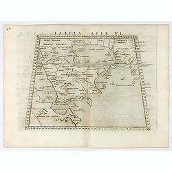
Tabula Asiae VI.
Uncommon first edition of this classical map of the Arabian Peninsular, is an enlarged version of Giacomo Gastaldi's published in 1548Girolamo Ruscelli's edition of Ptole...
- $750 / ≈ €702
Place & Date: Venice, 1561
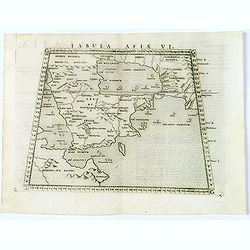
Tabula Asiae VI. (Arabian Peninsular)
Scarce FIRST edition of this classical map depicting the Arabian Peninsula, here called Arabia Foelix, the Persian Gulf and Red Sea. The map is based upon a map published...
- $300 / ≈ €281
Place & Date: Venice, 1561

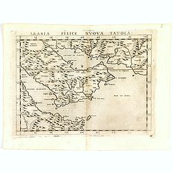
Arabia Felice Nuova Tavola.
Fine early map of Arabian peninsula, being one of the earliest modern maps of the region.Girolamo Ruscelli first published the map in his "La Geographi di Claudio To...
Place & Date: Venice, 1561
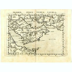
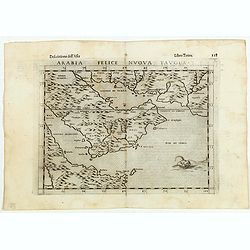
Arabia Felice Nuova Tavola.
Uncommon first edition of this modern map of Saudi Arabia, the Persian Gulf and Red Sea, for the first time it "clearly shows the island of Bahrain and Qatar".T...
Place & Date: Venice, Vincenzo Valgrisi, 1561
![Arabia Felice Nuova Tavola. [Arabian Peninsular]](/uploads/cache/40089-250x250.jpg)
Arabia Felice Nuova Tavola. [Arabian Peninsular]
Fine early map of this modern depiction of the Arabian peninsula, being one of the earliest modern maps of the region. The map extends from the Arabian Desert south as fa...
- $900 / ≈ €842
Place & Date: Venice, Vincenzo Valgrisi, c.1561
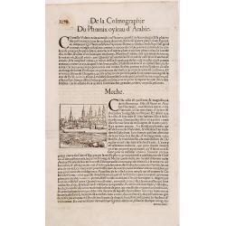
Meche.
Panoramic view of Mecca from Antoine du Pinet's "Plantz, Pourtraitz, Et descriptions De Plusieurs Villes". Woodblock print in text leaf with an interesting desc...
- $150 / ≈ €140
Place & Date: Lyon, 1564
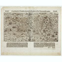
Constantinopel . . .
Early bird's eye view of Constantinople. From a German text edition of S. Münster's Cosmographia, which is a short and complete summary of Renaissance knowledge.Sebasti...
- $300 / ≈ €281
Place & Date: Basle, 1550-1580
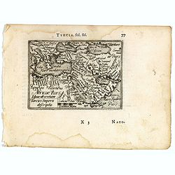
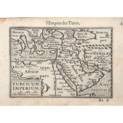
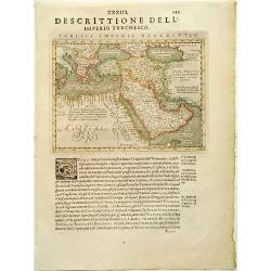
Turcici imperii descriptio.
Fine map of the Middle East, extending from Greece to Arabia and covering the Cradle of Civilisation region.Abraham Ortelius (1527-1598) was a cartographer and publisher ...
- $550 / ≈ €515
Place & Date: Antwerp, 1583
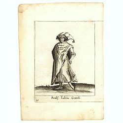
Arabs habitu Gentili.
Costume plate published by Pietro Bertelli in his "Diversarum nationum habitus", a sixteenth-century Italian costume book. The work was published with fold-out ...
- $50 / ≈ €47
Place & Date: Padua, 1589
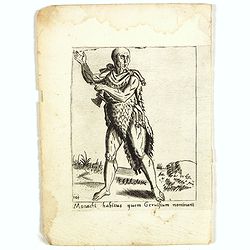
Monachi habitus guem Geruisium nominant.
Costume plate published by Pietro Bertelli in his "Diversarum nationum habitus", a sixteenth-century Italian costume book. The work was published with fold-out ...
- $50 / ≈ €47
Place & Date: Padua, 1589
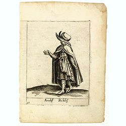
Arabs Nobilis.
Costume plate published by Pietro Bertelli in his "Diversarum nationum habitus", a sixteenth-century Italian costume book. The work was published with fold-out ...
- $70 / ≈ €66
Place & Date: Padua, 1589
Arabia Felice Nuova Tavola.
Fine early map of Arabian peninsula, being one of the earliest modern maps of the region.Girolamo Ruscelli first published the map in his "La Geographi di Claudio To...
- $850 / ≈ €795
Place & Date: Venice, 1598
Arabia Felice Nuova Tavola.
Fine early map of Arabian peninsula, being one of the earliest modern maps of the region.Girolamo Ruscelli first published the map in his "La Geographi di Claudio To...
Place & Date: Venice, 1598
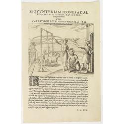
Seqvuntur Iam Icones ad Alteram Huius operis navigationem. . . (Water pump)
Illustration from seventh part of De Bry’s Petits Voyages, including Gasparo Balbi's voyage to Pegu via Syria in 1579-1588. The plate is showing a water pump driven by ...
- $100 / ≈ €94
Place & Date: Frankfurt, 1599
Turcicum Imperium.
A really attractive miniature map of The Turkish Empire, as it was at the beginning of the seventeenth century. Published by Petrus Bertius in Amsterdam. The map stretche...
Place & Date: Amsterdam, 1606

Ormus
A lovely map of miniature map the Kingdom of Ormus, published by Petrus Bertius, and published in Amsterdam at the beginning of the seventeenth century. With an attractiv...
Place & Date: Amsterdam, 1606

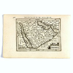
Arabia
A lovely miniature map the Arabian Peninsular, published by Petrus Bertius, and published in Amsterdam at the beginning of the seventeenth century. With an attractive s...
Place & Date: Amsterdam, 1606
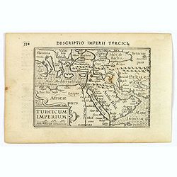
Descriptio Imperii Turcici / Turcicum Imperium.
A rare miniature map of the Arabian Peninsular. Title cartouche on the lower right corner.First published in 1598 in his Caert-Thresoor, the plates were executed by the m...
- $300 / ≈ €281
Place & Date: Amsterdam, Cornelis Claes, 1606

Descriptio Arabie / Arabia.
A rare miniature map of the Arabian Peninsular. The title cartouche on the lower right corner.First published in 1598 in his Caert-Thresoor, the plates were executed by t...
Place & Date: Amsterdam, Cornelis Claes, 1606
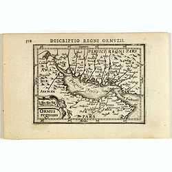
Descriptio Regni Ormuzii / Ormus.
A rare miniature map of the Street of Ormus. Title cartouche on the lower left corner.First published in 1598 in his Caert-Thresoor, the plates were executed by the most ...
- $450 / ≈ €421
Place & Date: Amsterdam, 1606
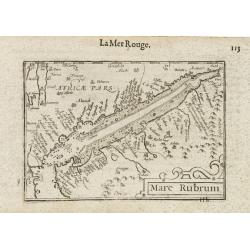
Mare Rubrum / Mer Rouge.
Wonderful miniature map includes the Red Sea, Yemen, and the east coast of the Arabian peninsula. One of the early maps to focus on this area. The title cartouche on the ...
- $300 / ≈ €281
Place & Date: Amsterdam / Frankfurt, 1609
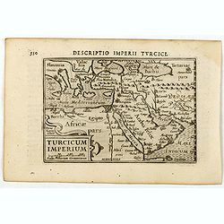
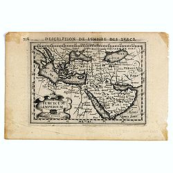
Turcicum Imperium / Empire Turc.
A miniature map of the Arabian peninsula, centered on Jerusalem. Title cartouche on the lower left corner.First published in 1598 in his Caert-Thresoor, the plates were e...
- $300 / ≈ €281
Place & Date: Amsterdam/Frankfurt 1609
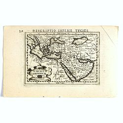
Turcicum Imperium.
FIRST IMPRINT FROM THE NEWLY ENGRAVED PLATES IN 1616. - A rare miniature map of the Arabian Peninsular. Title cartouche on the lower left corner.First published in 1598 i...
- $500 / ≈ €468
Place & Date: Amsterdam, J. Hondius, 1616
Turicum imperium.
FIRST IMPRINT FROM THE NEWLY ENGRAVED PLATES IN 1616. - A rare miniature map of the Ottoman empire with Turkey and the Arabian Peninsular. Title cartouche on the lower le...
- $500 / ≈ €468
Place & Date: Amsterdam, J. Hondius, 1616
Arabia.
FIRST IMPRINT FROM THE NEWLY ENGRAVED PLATES IN 1616. - A rare miniature map of the Arabian Peninsular. Title cartouche on the lower left corner.First published in 1598 i...
- $600 / ≈ €561
Place & Date: Amsterdam, J. Hondius, 1616
Turcici Imperii descriptio.
Finely and early map of the Turkish Empire giving good detail in the Arabian Peninsula. From Isolario, engraved by Girolamo Porro.Read more about Mapping of Arabia and o...
Place & Date: Padua, 1620
Selling price: $300
Sold in 2008
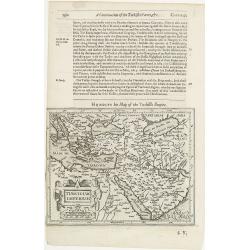
Turcicum Imperium.
The rare Samuel Purchas' edition of the Mercator / Hondius "Atlas Minor" atlas map. Early map of Turkey, the Arabian pen insular and eastern part of the Mediter...
- $300 / ≈ €281
Place & Date: London, 1625

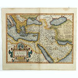
Turcici Imperii Imago.
The map shows the Ottoman Empire with Turkey, Black Sea, Mediterranean Sea, Arabia and North Eastern Africa. The map is decorated with a title cartouche and a portrait of...
Place & Date: Amsterdam, 1629
Turcici Imperii Imago.
A very decorative map. On top of title cartouche the portrait of Sultan Mahumet Turcorum Imperat .More about Mapping of Arabia [+]
- $1000 / ≈ €936
Place & Date: Amsterdam, 1633
Turcicum Imperium.
Early map of Turkey, the Arabian peninsula and eastern part of the Mediterranean.From the English edition of Mercator's Atlas Minor. This edition 1635. English text on ve...
- $400 / ≈ €374
Place & Date: Amsterdam, 1635
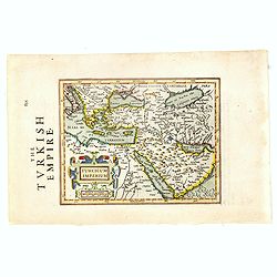
Turcicum Imperium.
A very handsome map with a particularly fine cartouche showing the Turkish Sultan on his throne and allegorical figures at either side brandishing weapons. At the right i...
- $1500 / ≈ €1404
Place & Date: Amsterdam, 1644
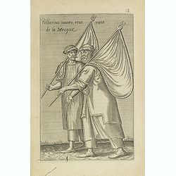
Pellerins mores, reue nuns de la Mecque.
Sought-after copper engraved plate from Laonikos Chalcocondyle’s "L'histoire de la décadence de l'empire grec et establissement de celuy des Turcs." by Thoma...
Place & Date: Paris, Mathieu Guillemot, 1650
![[Rare map centered on the Arabian Peninsular and India reaching till Malysia.]](/uploads/cache/42886-250x250.jpg)
[Rare map centered on the Arabian Peninsular and India reaching till Malysia.]
Early map of the Indian Ocean region, from the Eastern Mediterranean (Alexandria) to Malaysia and Sumatra. Shows The passage of Nimrod and The passage of Ophir en Hauilah...
- $750 / ≈ €702
Place & Date: London, John Saywell in 1652

Carte des Trois Arabies. Tiree en Partie de l'Arabe de Nubie, en Partie de Divers autres Autheurs. . .
Rare map of the Arabian Peninsula, first published in 1654 and one of the first large maps focused specifically on the Arabian Peninsula. Sanson's map of the Arabian Peni...
Place & Date: Paris, 1654
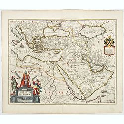
Turcicum Imperium.
A very handsome map with a particularly fine cartouche showing the Turkish Sultan on his throne and allegorical figures at either side brandishing weapons. At right is a ...
- $1100 / ≈ €1029
Place & Date: Amsterdam, 1658
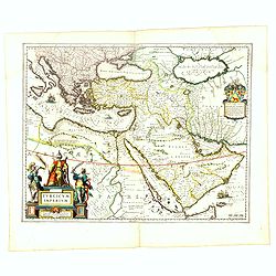
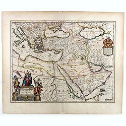
Turcicum Imperium.
A very handsome map with a particularly fine cartouche showing the Turkish Sultan on his throne and allegorical figures at either side brandishing weapons. At right is a ...
- $1500 / ≈ €1404
Place & Date: Amsterdam, 1658