Browse Listings in America > South America
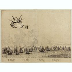
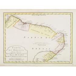
Quartum Praelium Coniovian inter et Fluvium Rio Grande XVII Ian
Decorative engraving of the fourth sea battle with the Portuguese fleet offshore at the Rio Grande, in1640. Engraved by J. van Brosterhuyzen after a design by Frans J. Po...
Date: Joannes Blaeu, Amsterdam 1647
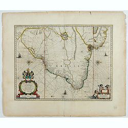
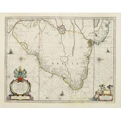
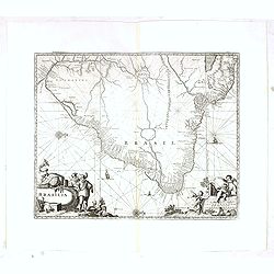
Brasilia.
Fine copy of this map by Krystof Arciszewski, a Polish general who worked for the Dutch West Indian Company. The map perpetuates various myths including the Parime Lago ,...
Date: Amsterdam, 1647

Rerum per octennium in Brasilia Et alibi nuper gestarum, Sub Praefectura Illustrissimi Comitis I. Mauritii, Nassoviae, (...) Historia.
First edition. Commissioned by Johan Maurits van Nassau (governor of Brazil between 1636-1644 and founder of "Mauritsstad" (present-day Recife)) and illustrated...
Date: Amsterdam, J. Blaeu, 1647
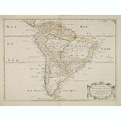
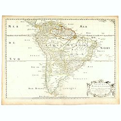
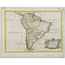
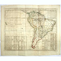
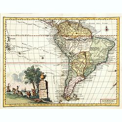
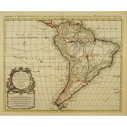
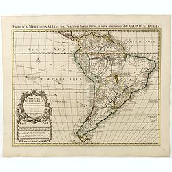
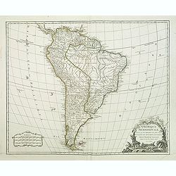
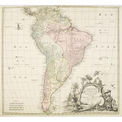
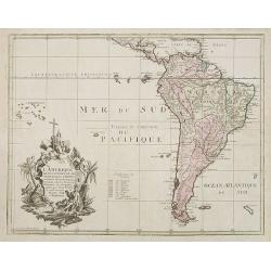
Amerique Meridionale. Par N.Sanson d'Abbeville. . .
The first edition of a cornerstone South America map, the first to show the boundaries of many countries, regions, and provinces. Peru is shown governing a huge tract of ...
- $500 / ≈ €432
Date: Paris, after 1650
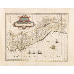
Peru.
Decorated with ships and monsters on the sea. Orientated with east at the top. Shows the Pacific coast of South America from Ecuador (at the left-hand side) as far south ...
- $400 / ≈ €346
Date: Amsterdam, 1658
Brasilia.
A mint example of this map is by Krystof Arciszewski, a Polish general who worked for the Dutch West Indian Company. The map perpetuates various myths including the Parim...
- $1250 / ≈ €1080
Date: Amsterdam, 1658
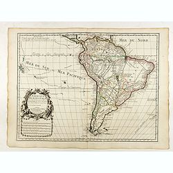
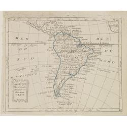
Amerique Meridionale. . . 1650.
First edition. A fine large map of South America, engraved by A.Peyrounin. The relatively unknown Amazon region is left without speculation. However, Sanson includes the ...
- $450 / ≈ €389
Date: Paris, 1650-1659

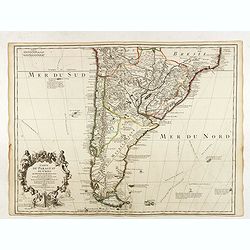
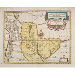
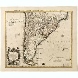
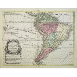
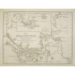
Paraquaria vulgo Paraguay cum adjacentibus.
Rare map only included in Joan Blaeu's Atlas major. Detailed map of Uruguay, Paraguay, Northern part of Argentina and northern part of Chili. Engraved by Gerard Coeck. Tw...
- $800 / ≈ €692
Date: Amsterdam, 1660
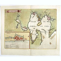
Sinus Omnium Sanctoru. Bahia de Todos os Sanctos.
RARE. First Atlas Major issue: originally issued by Blaeu in Casper van Baarle's 'Rerum per Octennium in Brasilia' (1647) dedicated to the former Governor of the Dutch co...
Date: Amsterdam, 1664
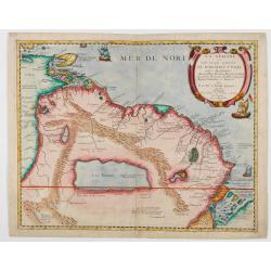
La Guaiane ou Coste Sauvage, autrement El Dorado, et Pais des Amazones…
An extremely rare edition of Du Val's map, separately published by Jollain in 1668, that references the name "El Dorado" in its title. The title translates as f...
Date: Paros, Chez Jollain, 1668
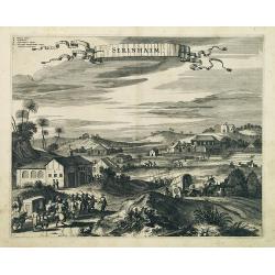
Serinhaim.
Fine view of a fort in Serinhaim, Brazil, with numbered key at the base. A procession of Portuguese or Dutch soldiers advance along the road carrying a litter. To the lef...
Date: London, 1671

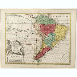
Brasila.
Map of Brazil extending from C. Nasou and Parime Lago to the Mouth of the Rio de la Plata. Oriented with West on top.The cartography of the region is quite primitive. The...
Date: Amsterdam, 1673
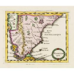
Magellani Que.
Uncommon miniature map of Argentina and Strait of Magellan from Pierre Duval's La Geographie Universeille dated 1676. Following his Cartes de geographie in 1657, Pierre D...
Date: Paris, 1676
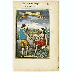
P.les du Chile.
A charming copper engraving depicting a town surrounded by a luxuriant landscape on the background and a couple of indigenous on the foreground.From the French text editi...
- $60 / ≈ €52
Date: Paris, 1683
F. Louys.
A charming bird's-eye view of Fort St Louis at Cayenne. Title in curtain draped at top. French text on verso.The fort is located on Mont Cépérou, with a panoramic view...
Date: Paris, 1683
L'America Meridionale . . .
The second edition of Rossi's map of South America, based upon Sanson's map, but with revised Italian nomenclature. From his 'Mercurio Geografico...'. The engraver was G...
Date: Rome, 1687
L'Amerique Meridionale Dressée sur les Observations de Mrs de l'Academie Royale des Sciences . . .
Rare state of " L’Amerique Meridionale. Chez l’Auteur sur le Quai de l’Horloge a la Courone de Diamans avec Privilege du Roy pour 20 ans, 1700".Fine map o...
Date: Paris, 1700
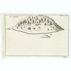
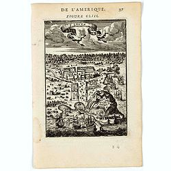
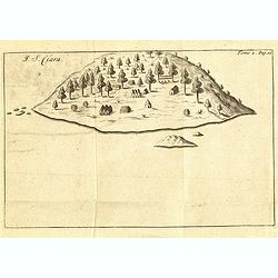
I. S. Clara.
Island "S. Clara" in Brazil just a few degrees north of the Tropic of Capricorn. From volume two of the French reissue of the account of early Dutch voyages. T...
- $150 / ≈ €130
Date: Amsterdam, E. Roger, 1703
Brasilia.
Very fine decorative map od Brazil with west to the top. From the book "A Collection of Voyages and Travels" by Churchill and the map came from the part contain...
- $550 / ≈ €475
Date: London, Printed for A. and J. Churchill, 1703
Carte du Paraguay du Chili.
A finely engraved, detailed map of the southern half of South America. Prepared by de l'Isle with the imprint "Chez l’Auteur sur le Quai de l’Horloge avec Privil...
Date: Paris, L. Renard, 1703
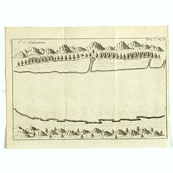
I. S. Sebastien.
Simplified bird's-eye view of Ilha de São Sebastiao, part of an archipelago off the southern coast of Brazil 210 miles from Rio de Janeiro. It was discovered on January ...
- $225 / ≈ €194
Date: Amsterdam, E. Roger, 1703
Paraguay o Prov. De Rio De La Plata cum regionibus adiacentibus Tucuman et Sta. Cruz De la Sierra.
An attractive map centered on Paraguay. Title cartouche on the upper right-hand corner, on the ocean a ship and a sea monster are depicted.
- $300 / ≈ €259
Date: Amsterdam, 1708
Nieuwe kaart van Suriname vertonende de stromen en land-streken van Suriname, Comowini, Cottica en Marawini, gelegen in Zuid America op de kusten van Caribana. . .
Decorative full color example of Ottens' map of Suriname. Detailed map of the northeast part of Suriname between Paramaribo, with fort Zeelandia, and Mana.Along the Surin...
Date: Amsterdam, ca. 1713-1718
Nouvelle carte de geographie de .. Meridionale de l'Amerique
Chatelain's map of South America. The title is in two lines across the map. The tracks of Magellan, de la Maire, de Mendana, etc. are shown.On each side, borders appear a...
- $250 / ≈ €216
Date: Amsterdam, 1719
Isle du Prince.
Simplified bird's-eye view of "Isle du Prince" in present-day Argentina.From volume two of the French reissue of the account of early Dutch voyages. The French ...
- $75 / ≈ €65
Date: Amsterdam, F. Bernard, 1725
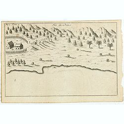
Porto il Desire.
Simplified bird's-eye view of Port Desire or Puerto Deseado in present-day Argentina.From volume two of the French reissue of the account of early Dutch voyages. The Fren...
- $150 / ≈ €130
Date: Amsterdam, F. Bernard, 1725
I. S. Clara.
Island "S. Clara" in Brazil just a few degrees north of the Tropic of Capricorn.From volume two of the French reissue of the account of early Dutch voyages. The...
- $100 / ≈ €86
Date: Amsterdam, F. Bernard, 1725

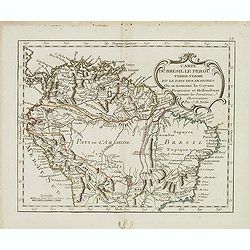
Tabula Americae Specialis Geographica Regni Peru, Brasiliae, Terra Firmae & Reg: Amazonum, Secundum relationes de Herrera, de Laet & PP d Acuña & M. Rodriguez . . .
A good and clean copy of Homann's map of the northern part of South America. The map is on the Valley of the Amazon and delineates the Amazon and its labyrinth of tributa...
Date: Nuremberg, 1728
![[þLot of 2 maps of South America] Carte de la Terre Ferme, du Perou, du Bresil, et du Pays des Amazones. . . [together with] Carte du Paraguai, du Chili...](/uploads/cache/48132-250x250.jpg)
[þLot of 2 maps of South America] Carte de la Terre Ferme, du Perou, du Bresil, et du Pays des Amazones. . . [together with] Carte du Paraguai, du Chili...
SET OF TWO MAPS: A handsome pair of maps that together make up South America. The first map is a northern part of America based on cartography by Guillaume Delisle.Fill...
Date: Amsterdam, 1728
Carta geografica della america meridionale.
Uncommon map of South America based upon Guillaume De L'Isle's map. Includes the routes of early explorers in the Pacific, including Magellan, Drake, Le Maire, Mendana, V...
Date: Venice, 1740

Paraquariae Provinciae Soc. Iesu cum Adjacentibus Novissima...
Between the years of 1609 and 1780, the Jesuits (the Roman Catholic Society of Jesus) established in South America, an autonomous Christian state, on the lands of present...
Date: Augsburg, 1740
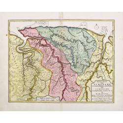
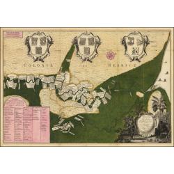
Algemeene kaart van de Colonie of Provintie van Suriname : met de rivieren, districten, ontdekkingen door militaire togten. . .
Uncommon large scale map of Suriname, indicating the different plantations and their owners. Consists of two glued-together sheets. Completed with funding by the Directeu...
Date: Amsterdam, 1740
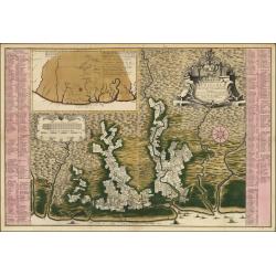
Naaukeurige Platte Grond van den Staat en den Loop van Rio de Berbice Met derzelver Plantagien in de Geoctrojeerde Colonie de Berbice Gelegen. . .
Uncommon large-scale map of Berbice with Rio de Berbice and Rio de Canje, with at the bottom left a list of plantation owners. In the top 3 x 3 coats of arms in cartouche...
Date: Amsterdam, 1740
L'Amerique Meridionale Dressée sur les Observations..
Detailed map of South America prepared by De L'Isle, with fine title cartouche.The map is from a Dutch edition of De L'Isle's work entitled, Atlas Nouveau, Contenant Tout...
- $500 / ≈ €432
Date: Amsterdam c. 1745
Carte du Paraguay, du Chili, du Detroit de Magellan &c.
Large handsome map of the southern part of the continent with good interior detail for the period. The route of 18th century explorations are shown along with notations c...
Date: Amsterdam c. 1745
L'Amerique Meridionale Dressée sur les Observations . . .
Detailed map of South America prepared by De L'Isle, with fine title cartouche.
Date: Amsterdam, ca. 1745
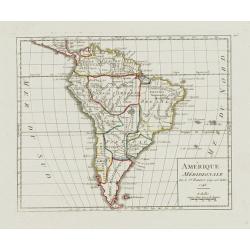
Amérique Méridionale.
Nice small map of South America. Dated 1748. From Atlas Portatif Universel, by Robert de Vaugondy.Page 105 outside border top right. Mary Sponberg Pedley does not mention...
- $75 / ≈ €65
Date: Paris, later than 1748
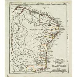
Terre de Sainte Croix, nommée à présent Bresil.
Detailed small map showing most part of the Brazilian seacoasts, from the mouth of the Amazon River as far as the island of Sao Sebastiao.From Atlas Portatif Universel, b...
- $75 / ≈ €65
Date: Paris, later than 1749
Amerique méridionale. . .
Detailled map of South America from his "Atlas Universel".Gilles Robert de Vaugondy (1688–1766), also known as Le Sieur or Monsieur Robert, and his son, Didie...
- $150 / ≈ €130
Date: Paris, 1750

Typus Geographicus Chili Paraguay Freti Magellanici &c.
Detailed map covering the southern part of the continent based on the cartography of Delisle and the information gleaned from the voyages of Brouwer, Narbouroug and Beauc...
Date: Nuremberg, 1750
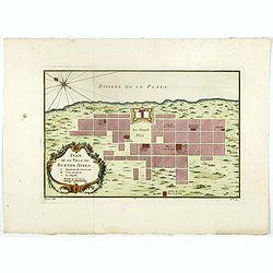
Plan de la ville de Buenos-Ayres.
Early plan of Buenos-Ayres city. Across the top is an extensive list of 22 important sites and locations keyed to the plan with tiny letters and numbers.Jacques Nicolaas ...
- $300 / ≈ €259
Date: Paris, 1750
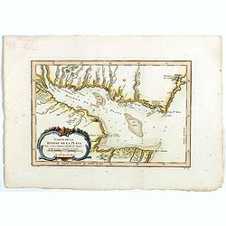
Carte de La Riviere de la Plata . . .
Map of La Plata Riviera. Across the top is an extensive list of 22 important sites and locations keyed to the plan with tiny letters and numbers.Jacques Nicolas Bellin (1...
- $350 / ≈ €303
Date: Paris, 1750
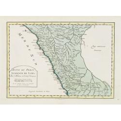
Suite de Perou Audience de Lima.
Uncommon edition of this accurate map showing the southern Peruvian coast, the ranges and villages of numerous Indian tribes are shown.FromAtlas Portatif pour servir a l'...
Date: Amsterdam, 1756
L'amerique meridionale dressee sur les memoires le plus recens. . .
Rare and decorative map of South America with good detail and interesting notations concerning the explorations of the interior. With in the lower right corner a title ca...
- $550 / ≈ €475
Date: Amsterdam, 1757
America Meridionalis.
This is the more scarce edition with the title cartouche lower left surrounded by Neptune and a native Indian.A rather accurate depiction and descriptions of South Americ...
- $550 / ≈ €475
Date: Augsburg, c. 1760
America Meridionalis.
The title cartouche lower left surrounded by native Indians and an Elephant.A rather accurate depiction and descriptions of South America. Brazil is slightly enlarged and...
Date: Augsburg, c. 1760

Nader prolongatie van het Octroy voor de Westindische Compagnie voor den tyd van nog dertig jaaren. . .
A proclamation by the Dutch States General, dated 1761, extending the charter of the Dutch West India Company for another thirty years. Like the 1730 proclamation, it has...
Date: Amsterdam, 1761
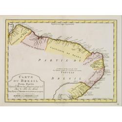
Carte du Bresil Prem.Partie...
Uncommon edition of this accurate map of the eastern part of Brazil.From Atlas Portatif pour servir a l'intelligence de l'Histoire Philosophique et Politique des etabliss...
- $100 / ≈ €86
Date: Amsterdam, 1773
Carte du Bresil Prem. Partie..
Uncommon edition of this accurate map of eastern part of Brazil. In lower right engraved 29a.From Atlas Portatif pour servir a l''''intelligence de l''''Histoire Philosop...
Date: Amsterdam, 1773
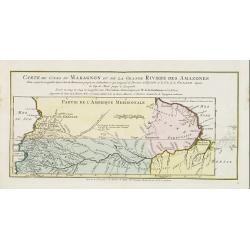
Carte du Cours du Maragnon ou .. Amazones..
Uncommon edition of this map of the river Amazon. In lower right engraved "30."From Atlas Portatif pour servir a l'intelligence de l'Histoire Philosophique et P...
Date: Amsterdam, 1773
L'America meridionale divisa nei suoi principali stati.
Rare map of south America, from "Atlante Novissimo ad uso Dei Giovani Studiosi Contenuto In Carte XXVII.", published by Giovanni Zempel in Rome, ca. 1780.The ma...
- $100 / ≈ €86
Date: Rome, 1780
Carte du Bresil le Perou. . .
Scarce map of Northern part of South America with Venezuela, Colombia, Brazil and Peru, prepared by Nolin and published by L.J. Mondhare for his Atlas Général a l'usage...
- $125 / ≈ €108
Date: Paris, 1781
Karte der Magellanischen-Strasse. . .
Very detailed map of Strait of Magellan, with in top inset map of Southern tip of South America with the Falklands. Prepared by Don Juan de La Cruz of Spain.Engraved by J...
- $600 / ≈ €519
Date: Vienna, 1789
L'Amerique selon l'Etendue de Ses Principales Parties et don't les Points Principaux. . .
Uncommon map of South America, decorated with an elaborate cartouche referring to the conversion of the natives to Christianity, with natives bowing to a figure holding a...
Date: Augsburg, ca. 1790
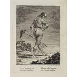
Uomo del Paraguai nell' America Meridionalle. / Homme du Paraguai dans l'Amerique Meridionalle.
Full portrait of a person from Paraguay. From "Raccolta di stampe." a series of historically significant eighteenth-century copper plate engravings by Venetia...
Date: Venice, Antonio Zatta, c.1790
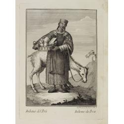
Indiana del Perù. / Indienne du Perou.
Portrait of a Peruvian Indian woman holding a fruit basket and a lama in the background. From "Raccolta di stampe." a series of historically significant eight...
Date: Venice, Antonio Zatta, c.1790
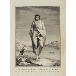
Uomo del Canale di Noël della terra del Fuoco, nel Mar Australe. / Homme du Canal de Noël de la terre de Feu dans la Mer Australe.
Full portrait of a man from Christmas Sound, in Tierra del Fuego This engraved print on laid paper is from "Raccolta di stampe," a series of historically sign...
Date: Venice, Antonio Zatta, c.1790
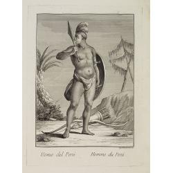
Uomo del Perù. / Homme du Perou.
Full portrait of a Peruvian warrior. From “Raccolta di … stampe.” a series of historically significant eighteenth-century copper plate engravings by Venetian engrav...
Date: Venice, Antonio Zatta, c.1790

Géographie des Plantes Equinoxiales - Tableau physique des Andes et pays voisins. . .
Physical Portrait of the Andes and adjacent lands", organized around the Chimborazo and Cotopaxi volcanoes in Ecuador.With local vegetation is illustrated pictoriall...
Date: Paris, 1805

Paraguay, Chili, Terre Magellan ?
Map of Paraguay, Chili, and Argentina . By C. F. Delamarche, successor of Robert de Vaugondy, Geographer.
Date: Paris, 1794 -1806
L'Amérique Méridionale, Divisée en ses Principaux Etats.
Map of South America, from Atlas de la Géographie de toutes les parties du monde .. Ouvrage destiné pour l'education, et nécessaire aux négocians, aux voyageurs, aux ...
Date: Paris, Prudhomme, Levrault, Debray, 1806

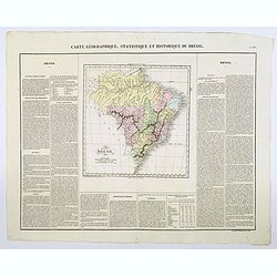
Carte Geographique, Statistique et Historique de l'Amerique Meridionale.
A nice detailed map of South America from Buchon's Atlas Gégraphique Statistique, historique et chronologique des deux Ameriques et des isles adjacentes traduit de l'atl...
Date: Paris, 1825

Carte Geographique, Statistique et Historique du Perou.
A nice detailed map of Peru from Buchon's Atlas Gégraphique Statistique, historique et chronologique des deux Ameriques et des isles adjacentes traduit de l'atlas exécu...
Date: Paris, 1825

Carte Geographique, Statistique et Historique de Buenos-Ayres.
A nice detailed map of what is today northern Argentina (Rep. of Buenos Ayres or the United Provinces of South America) from Buchon's Atlas Gégraphique Statistique, hist...
Date: Paris, 1825
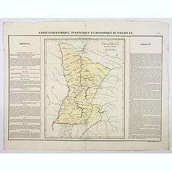
Carte Geographique, Statistique et Historique du Paraguay.
A nice detailed map of Paraguay from Buchon's Atlas Gégraphique Statistique, historique et chronologique des deux Ameriques et des isles adjacentes traduit de l'atlas ex...
Date: Paris, 1825
Carte Geographique, Statistique et Historique du Bresil.
A nice detailed map of Brazil from Buchon's Atlas Gégraphique Statistique, historique et chronologique des deux Ameriques et des isles adjacentes traduit de l'atlas exé...
Date: Paris, 1825
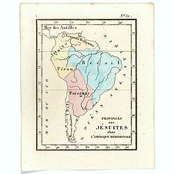
Prvinces des Jésuites dans l'Amerique méridionale.
Rare map of South America from "Atlas Universel indiquant les établissemens des Jésuites: avec la manière dont ils divisent la terre, suivi desévénemens remarqu...
- $200 / ≈ €173
Date: Paris, Ambroise Dupont , 1826
![[The Callo Palace ].](/uploads/cache/27288-250x250.jpg)
[The Callo Palace ].
Aquatint depicting Peruvian Inca Palace called Callo.Engraved by Fumagalli.From Giulio Ferrario's work Le Costume Ancien et Moderne ou Histoire du gouvernement, de la mil...
- $80 / ≈ €69
Date: Milan, 1827
![[The Callo Palace.]](/uploads/cache/27289-250x250.jpg)
[The Callo Palace.]
Aquatint depicting upper portion of print an Inca Palace near Cannar in the province of Quito in Peru. Bottom portion a plan of the palace (70 x 160).Engraved by Fumagall...
- $80 / ≈ €69
Date: Milan, 1827
![[Spanish Sheppard's in Paraguay ].](/uploads/cache/27290-250x250.jpg)
[Spanish Sheppard's in Paraguay ].
Aquatint depicting Spanish Sheppard's in Paraguay.Engraved by Gallina.From Giulio Ferrario's work Le Costume Ancien et Moderne ou Histoire du gouvernement, de la milice, ...
- $50 / ≈ €43
Date: Milan, 1827
![[ The circular fortress of Cannar, Peru. ]](/uploads/cache/27292-250x250.jpg)
[ The circular fortress of Cannar, Peru. ]
Aquatint depicting the circular fortress of Cannar, Peru.Engraved by Fumagalli.From Giulio Ferrario's work Le Costume Ancien et Moderne ou Histoire du gouvernement, de la...
- $80 / ≈ €69
Date: Milan, 1827
![[ Fortresss of Cannar in Quito Peru ].](/uploads/cache/27293-250x250.jpg)
[ Fortresss of Cannar in Quito Peru ].
Aquatint depicting the fortress of Cannar in Quito Peru inspired by a print from atlas by Alexander Von Humboldt.Engraved by E. F.From Giulio Ferrario's work Le Costume A...
- $80 / ≈ €69
Date: Milan, 1827
![[ Santiago inhabitants in their local dress. ]](/uploads/cache/27294-250x250.jpg)
[ Santiago inhabitants in their local dress. ]
Aquatint depicting inhabitants of Santiago in local dress.Engraved by Gallina.From Giulio Ferrario's work Le Costume Ancien et Moderne ou Histoire du gouvernement, de la ...
- $50 / ≈ €43
Date: Milan, 1827
![[ Guayanas inhabitants Paraguay ].](/uploads/cache/27295-250x250.jpg)
[ Guayanas inhabitants Paraguay ].
Aquatint depicting some relexing Guayanas Indians of Paraguay, who occupy the rivers flowing to the right bank of the Parana.The Charruas Indians were the first inhabitan...
- $50 / ≈ €43
Date: Milan, 1827
![[ Charruas Indians from Paraguay ].](/uploads/cache/27296-250x250.jpg)
[ Charruas Indians from Paraguay ].
Aquatint depicting the Charruas Indians cooking. The charruas Indians were the first inhabitants who hunted and fished in the area now known as Uruguay. They have probabl...
- $60 / ≈ €52
Date: Milan, 1827
![[ Indians playing Queciu (top) and Porotos (bottom) ].](/uploads/cache/27298-250x250.jpg)
[ Indians playing Queciu (top) and Porotos (bottom) ].
Aquatint depicting Indians playing Queciu (top) and Porotos (bottom).Engraved by Fumagalli.From Giulio Ferrario's work Le Costume Ancien et Moderne ou Histoire du gouvern...
- $50 / ≈ €43
Date: Milan, 1827
![[ Chilean indians playing ciueca ].](/uploads/cache/27299-250x250.jpg)
[ Chilean indians playing ciueca ].
Aquatint depicting Chilean indians playing "ciueca", a native hockey-like game.Engraved by Fumagalli.From Giulio Ferrario's work Le Costume Ancien et Moderne ou...
- $75 / ≈ €65
Date: Milan, 1827
![[Jesuitical Indians at work at their 'Reducciones' ]](/uploads/cache/27300-250x250.jpg)
[Jesuitical Indians at work at their 'Reducciones' ]
Aquatint depicting Jesuitical Indians in Paraguay. The Jesuit Missions or "Reducciones" functioned like small independent "republics" and lived in com...
- $80 / ≈ €69
Date: Milan, 1827
![[Araucani chief and his entourage from Chile ].](/uploads/cache/27302-250x250.jpg)
[Araucani chief and his entourage from Chile ].
Aquatint depicting an Araucani chief and his entourage. They were known as the toughest indigenous people of South America. The Araucans are Amerindian tribes habiting th...
- $85 / ≈ €73
Date: Milan, 1827
![[Indians of Patagonia, Chile, greeting a European traveller, probably Louis Antoine de Bougainville. ]](/uploads/cache/27303-250x250.jpg)
[Indians of Patagonia, Chile, greeting a European traveller, probably Louis Antoine de Bougainville. ]
Aquatint depicting Indians of Patagonia, Chile, greeting a European traveller, probably Louis Antoine de Bougainville. Comte de Bougainville was a French admiral and expl...
- $75 / ≈ €65
Date: Milan, 1827
